After a searing June, a more comfortable July…so far.
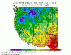
Truly scorching heat baked the Southwest during June–with inland desert regions in southern California, Arizona and Nevada shattering monthly high temperature records and approaching all-time heat records.

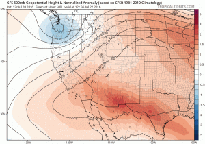
Northern California was largely spared SoCal’s relentlessly high temperatures, courtesy of a Pacific Northwest trough that ended up being more persistent than expected. The first half of July, on the other hand, has been rather quiescent across California. Temperatures over the past couple of weeks have actually be somewhat below average across much of the state in recent days (an increasingly rare occurrence in recent years). Unfortunately, these relatively mild temperatures will shortly give way to building heat once again as high pressure over the Southwest regains strength in the coming days.
Late July heatwave to bake California once again
It is admittedly the middle of summer, and occasional July heatwaves are not that unusual in California. And the upcoming heat does is not likely to be as intense as June’s record-breaking values, at least in SoCal. But what the upcoming heat event may lack in absolute intensity it may make up for with longevity–after a slow build into the weekend, hot temperatures are likely to persist for the foreseeable future (10+ days) across almost the entire state. And the parts of NorCal that missed out on the June heat will probably be quite a bit warmer this time around–meaning that wildfire risk, which has been relatively modest in recent days, will rise considerably.

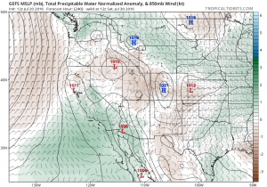
Also of interest this time of year is whether a building ridge over the Southwest might induce some moisture-laden monsoonal flow from the southeast. In this case, it appears that at least initially the answer is no–flow trajectory over the next week does not look particularly favorable for the advection of significant amounts of monsoonal moisture into California.

This may change by the following weekend, though, as the enhanced ridge axis shifts from slightly offshore to a more easterly position near the 4-Corners. The GFS ensemble suggests that a significant moisture surge may indeed occur over California in the 7-10 day period as southeasterly flow persists for a long duration–although the global models are notoriously unreliable when it comes to timing westward incursions of the North American Monsoon (just last week, they suggested that there would be one such moisture surge this week!).
An update on the tropical Pacific
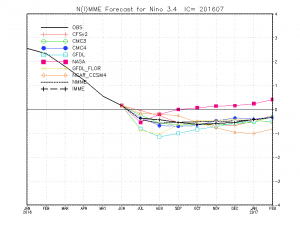
There’s been much discussion regarding La Niña in recent months as the California drought persisted through one of the most powerful El Niño events on record. A couple of months ago, dynamical models suggested a very strong possibility of La Niña conditions of at least modest magnitude developing by autumn 2016. More recent simulations, however, paint a somewhat different picture–suggesting only marginally cool conditions in the eastern tropical Pacific Ocean over the coming 6 months.

This is a fairly marked departure from earlier forecasts–and even more remarkable is that this forecast shift appears to be occurring across a wide range of models run by various international scientific institutions. At this point, it’s hard to say what this change means for California next winter–and time will tell whether it’s just a blip on the radar or the start of a sustained trend away from La Niña. The vast majority of significant El Niño events in history have been immediately followed by La Niña–so this could be an interesting development from a global climate perspective if it ultimately comes to pass. I’ll continue to follow in the coming months!