Drought update: how did California fare during 2015-2016 winter?
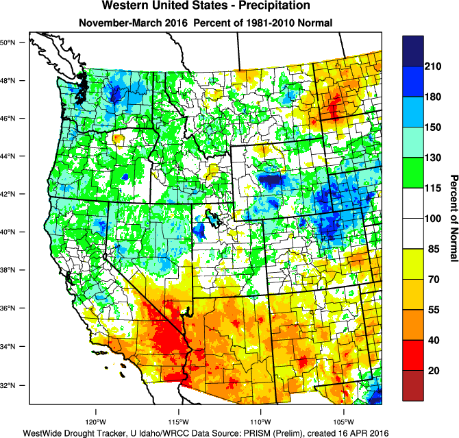
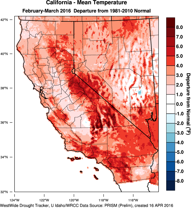
With the formerly powerful El Niño event now fading in the tropical Pacific and most of California’s traditional rainy season now behind us, it’s a good time to consider the modest drought relief that occurred in California this past winter. First, the good news: the northern half of California fared pretty well precipitation wise, with virtually all of the state from the Bay Area northward experiencing near or above average season-to-date precipitation. The northernmost portion of the state–where much of California’s water storage infrastructure resides–did particularly well, with many areas seeing more than 130-150% of the long term average. Sierra Nevada snowpack was a bit of a mixed bag, ranging from near average in the north to significantly below average in the south (though still far above last year’s record-low levels virtually everywhere). Statewide, snowpack ended up below the long-term average and is now melting rapidly–largely due to warm mountain temperatures which (yet again) persisted through the winter. Many short-term drought indicators have improved considerably in response to this precipitation, and many of California’s major reservoirs are actually in better shape than they have been in years.
But while NorCal precipitation this winter was enough to stabilize the long-term accumulated precipitation deficit, it didn’t really even make a dent in the still tremendous multi-year shortfall that has developed since 2012.
Further south, this past winter was even more disappointing. Outside of a few brief (but intense) bouts of storminess, the storm track largely stayed north of Los Angeles–bringing yet another very dry winter to the southern third of the state. To add insult to injury, very warm coastal temperatures have persisted through much of the winter. In fact, residents of coastal Southern California have now endured their third consecutive winter with temperatures higher than those during any other winter in living memory prior to 2014. Multi-year precipitation deficits actually increased during 2015-2016 in the Los Angeles area–a frustrating conclusion to a year that initially appeared quite likely to be wetter than average.
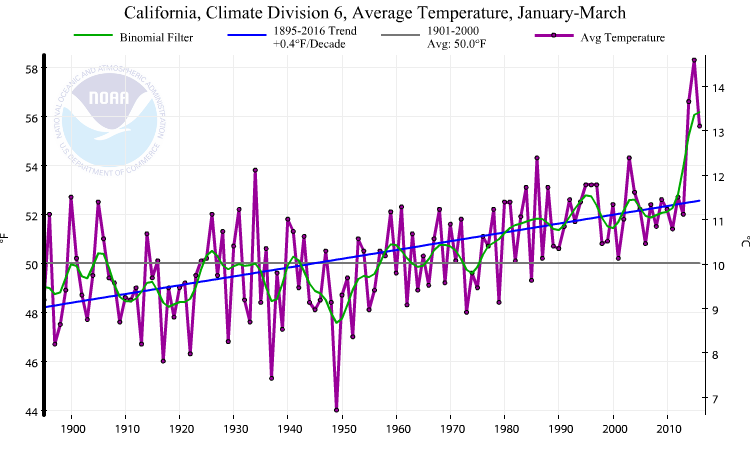
As I’ve previously discussed (and as Bob Henson recently explored in this piece), this year’s unusual precipitation pattern along the West Coast was almost exactly the opposite of what would have been expected based upon theoretical and empirical models for ENSO teleconnections–2015-2016 was very wet indeed in the Pacific Northwest, but very dry throughout the Desert Southwest. Interestingly, temperatures this winter were above average across virtually all of North America–which probably shouldn’t be too surprising, given the record-shattering global warmth in recent months. I’ll have another post in the future more closely considering the causes and implications of this unexpected ENSO evolution.
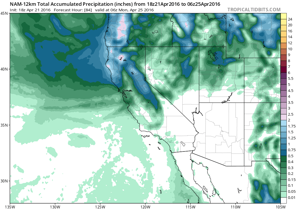
April showers in NorCal on Friday; more widespread next week
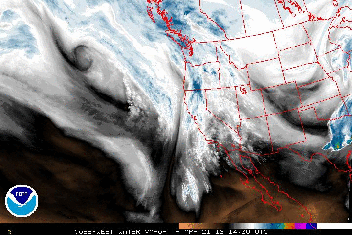
A fairly typical April pattern will take hold over the next 10 days across California, with occasional bouts of light to moderate precipitation. Tomorrow’s system will be aimed primarily at NorCal (generally from the Bay Area northward), but could drop a respectable amount of rain and mountain snow over the northern portion of the state. With the increasingly strong April sun, some thunderstorms will likely occur tomorrow–particularly in the Sacramento Valley, where a couple of isolated severe thunderstorms would not be out of the question. As is typical for the highly changeable conditions in spring, the medium range models suggest a continued potential for additional showery periods over the next 10 days or so. A system later next week stands a better chance at bringing precipitation to SoCal, though cut-off lows and inside slider-type systems are notoriously fickle and that forecast will likely bounce around quite a bit in the coming days. At a bare minimum, it does appear that all of California will likely see a reprieve from the record heat of recent days.
La Niña increasingly likely for 2016-2017 winter
I’ll start with the usual caveat that we’re still on the wrong side of the “Spring Predictability Barrier,” and that it’s hard to say anything with high confidence specifically regarding next winter at this early date. But at the moment, virtually all of the American and international dynamical models suggest a rather rapid transition toward La Niña conditions in the tropical Pacific Ocean by late summer, with cool tropical anomalies likely persisting or intensifying through the autumn. Interestingly, however, these models are also in agreement that conditions outside of the tropical Pacific may remain remarkably warm though at least next autumn–particularly over the Northern Hemisphere continents and the Arctic.
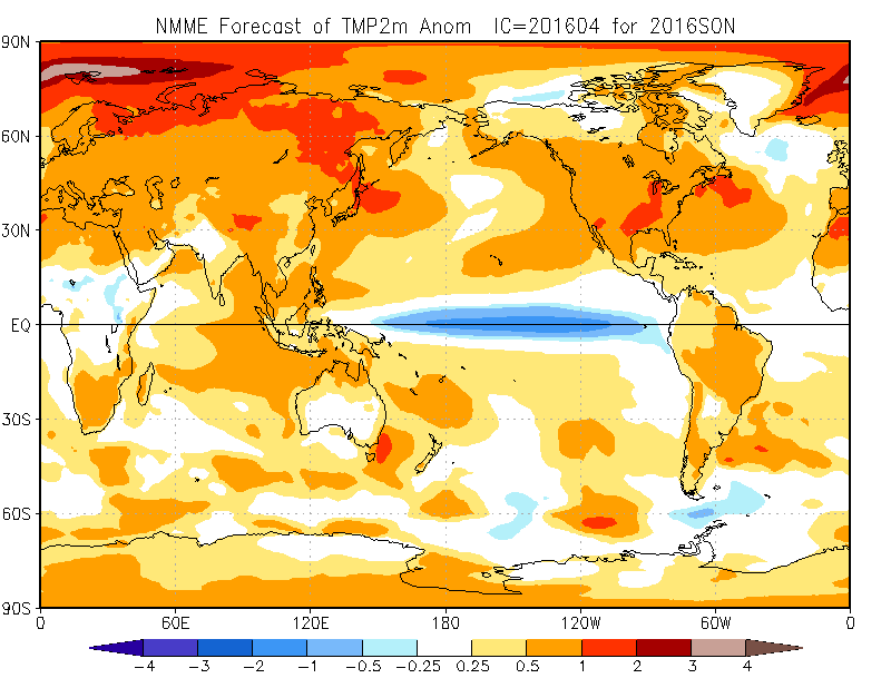
What might this mean for California next winter? Well, La Niña in general is associated with an even wider range of outcomes than El Niño along the West Coast of North America. The strongest connection is to dry winters in Southern California (yes, yes, I know). Northern California has has historically experienced both very dry and very wet winters during La Niña, though the balance tips toward dry conditions on average. It’s worth noting that the atmospheric pattern most commonly with La Niña is a persistent ridge somewhere over the Pacific west of California–meaning that whether California sees a dry winter or not will likely depend on precisely how far east this ridge extends. The North American Multi-Model Ensemble is currently forecasting surprisingly warm ocean temperatures once again along the West Coast of North America despite cool tropical Pacific temperatures–which may suggest an increased likelihood of West Coast ridging next winter. We’ll know more in a few months, but preliminary indications do not favor drought relief during the 2016-2017 winter in California.
Discover more from Weather West
Subscribe to get the latest posts sent to your email.