Cool NorCal coast; warm SoCal and inland
Just how warm this summer has felt in California depends largely upon who you ask. Residents of immediate coastal Northern California–including most of the Bay Area–have benefited from nature’s air conditioning so far this season.
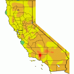
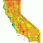
Relatively cool ocean temperatures just offshore (a product of increased coastal upwelling this year) have resulted in a robust marine layer, and the traditional “June Gloom” associated with California’s marine stratus has persisted into August in some spots.
Meanwhile, across all of Southern California and even more inland parts of Northern California, this summer has been yet another hot one–and several heatwaves have occurred since June. Unusually warm ocean conditions have persisted along the SoCal coastline, keeping the marine influence in check and allowing for very hot conditions at times just a few miles inland from the immediate coastline.
A remarkably inactive summer monsoon
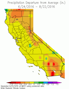
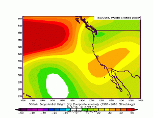
In stark contrast to last year’s hyperactive summer weather conditions across Southern California–which was characterized by a number of very unusual, out-of-season heavy convective precipitation events–conditions so far this season have been notably quiescent across California. This is true even in parts of the state (primarily the mountains and deserts of Southern California and the Sierra Nevada range) which do see meaningful precipitation during the North American Monsoon. The proximal cause of these monsoonal doldrums across California appears to be the westward extension (or displacement) of the “4-Corners High,” which is typically an anchoring feature of the Monsoon. During a typical summer, pulses of moist and relatively unstable air can move from east to west across the Desert Southwest in the clockwise flow around the 4-Corners High–sometimes triggering mountain and desert thunderstorms during the warm season. So far during summer 2016, though, this high pressure area has been centered almost directly over California. As a result, there have been remarkably few convectively active periods so far this season (although a handful of locations did fare a bit better over the past week).
Destructive, dangerous California wildfires rage despite lack of wind events
Summer 2016 has also featured a series of particularly destructive wildfires across a wide swath of California–several of which have separately destroyed hundreds of homes and caused widespread evacuations. Truly extreme fire behavior has occurred on virtually all of California’s major fires this summer, with fast-moving flame fronts, large and visually spectacular pyrocumulus clouds, and at least a handful of fire-induced vortices.
https://twitter.com/sl8ty/status/765730822376726528
Interestingly (and somewhat disconcertingly), many of these fires have occurred despite the absence of strong and dry offshore wind events that often drive California’s most destructive fires. Instead, most of the current fires in California appear to be preferentially favoring those regions hardest hit in California’s ongoing, multi-year drought. Vegetation fuel moistures and “energy release components” (measures of flammability and potential combustion intensity, respectively) in these regions have reached or exceed record values this summer. While there is an increasing amount of evidence that California’s astonishing drought-related recent tree mortality may not directly increase wildfire intensity in the long run, it’s pretty clear that California’s severe drought has been exerting a strong influence upon fire risk and behavior across California over the past couple of years in other ways.
Fuel moistures near all-time minimums for this time of year in the #SanBernardino mountains. #BlueCutFire #cawx pic.twitter.com/te8c8YGQF2
— NWS San Diego (@NWSSanDiego) August 18, 2016
Early indications not encouraging for CA drought relief this winter
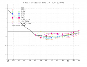
A substantial La Niña event no longer appears to be in the cards for the coming winter. Model simulations agree with recent observations showing a leveling-off of cool ocean temperature anomalies in the tropical eastern Pacific Ocean. Instead of intensifying through the coming winter, the best evidence now suggests these weak cool anomalies are likely to persist for a few more months before gradually warming towards neutral during mid-winter.
This latest development suggests that La Niña probably won’t be a big player during the coming California winter. If it’s present at all, it will probably be quite weak–and there really aren’t any reliable conclusions that can be drawn regarding the influence of weak La Niña events upon California wintertime precipitation.
Is the probable lack of a moderate or strong La Niña during 2016-2017 good news for California? Well, it’s certainly true that a strong La Niña would probably be bad news for Southern California–which fared quite poorly precipitation-wise even during one of the strongest El Niño events on record last year. But as Californians have become painfully aware in recent years, La Niña is not the only possible cause of dry conditions and drought in California. The latest seasonal predictions–which are based upon simulations of an ensemble of ocean-atmosphere models that take into account the present state of the atmosphere, global oceans, and sea ice–do not inspire a great deal of hope that the coming winter will bring widespread drought relief. At the moment, these simulations depict a pattern characterized by persistent West Coast winter ridging. This setup looks a fair bit like the Ridiculously Resilient Ridge, and is similar to the kind of atmospheric ridge patterns we’ve started to see more frequently in recent decades.
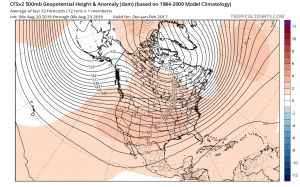
Does all of this mean that we’re in for another dry winter in California? Not necessarily. We need look no further than last year for an example of how subtle shifts in the large-scale atmospheric pattern can lead to large differences in the outcome here in the climatologically unusual Golden State. But it is probably worth reiterating that the drought certainly continues here in California–and the possibility of its persistence or re-intensification is certainly on the table. Stay tuned.
Discover more from Weather West
Subscribe to get the latest posts sent to your email.