Quite some whiplash: from record heat to record wet (and yet one more damaging wildfire before that happens)
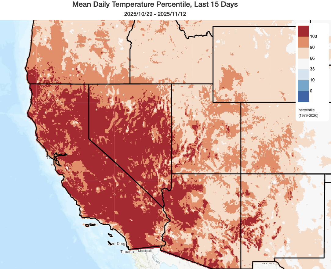
Well, the weather this year sure is doing its best to keep us on our toes! The last 2-3 weeks featured record (or near-record) warmth across most of California and Nevada, as well as a good portion of other Western U.S. states. That follows a spring and first half of summer that defied expectations are ended up very much on the cool side of things. Had this record Oct-Nov warmth coincided with exceptionally dry vegetation conditions and/or major offshore wind events, it could have yielded a major fire weather event. But it did not (and, notably, was also correctly *predicted* not to!)–largely thanks to anomalous early fall rainfall nearly statewide, which kept things moister than usual for the time of year. (It also helped that north/east wind events during this period were pretty tame.)
In fact, we nearly escaped seeing any substantially destructive wildfires after early September in California…until yesterday, that is. Despite recent rainfall, 3 dry and near-record warm weeks did dry out vegetation enough to allow a fast-moving and wind-driven wildfire to spread amid strong downslope pre-frontal winds (gusting over 70 mph) on the Sierra Nevada lee (east) side yesterday. Despite its modest ~3,000 acre footprint, mainly in grass and shrubs, the fire initially outpaced the ability of fire crews to stem its spread under very strong wind conditions (which also prevented aircraft from conducting retardant drops). The Pack Fire, which ultimately jumped Highway 395 and burned through the McGee Creek area, damaged or destroyed an unknown number of structures (through the latest informal intel suggests ~15-20) even as rain and snow fell on the mountain peaks just a few miles to the west. Sierra lee side fires can occur, and have a number of times historically, immediately in advance of major winter storms that would otherwise extinguish them as the downslope flow (here, west to east) induced by the “rain shadow” from the high Sierra peaks creates a localized environment conducive to rapid fire spread.
Major Southern California storm looks much more impressive vs. a few days ago; considerable flood threat centered on LA Basin, with some severe thunderstorms also possible
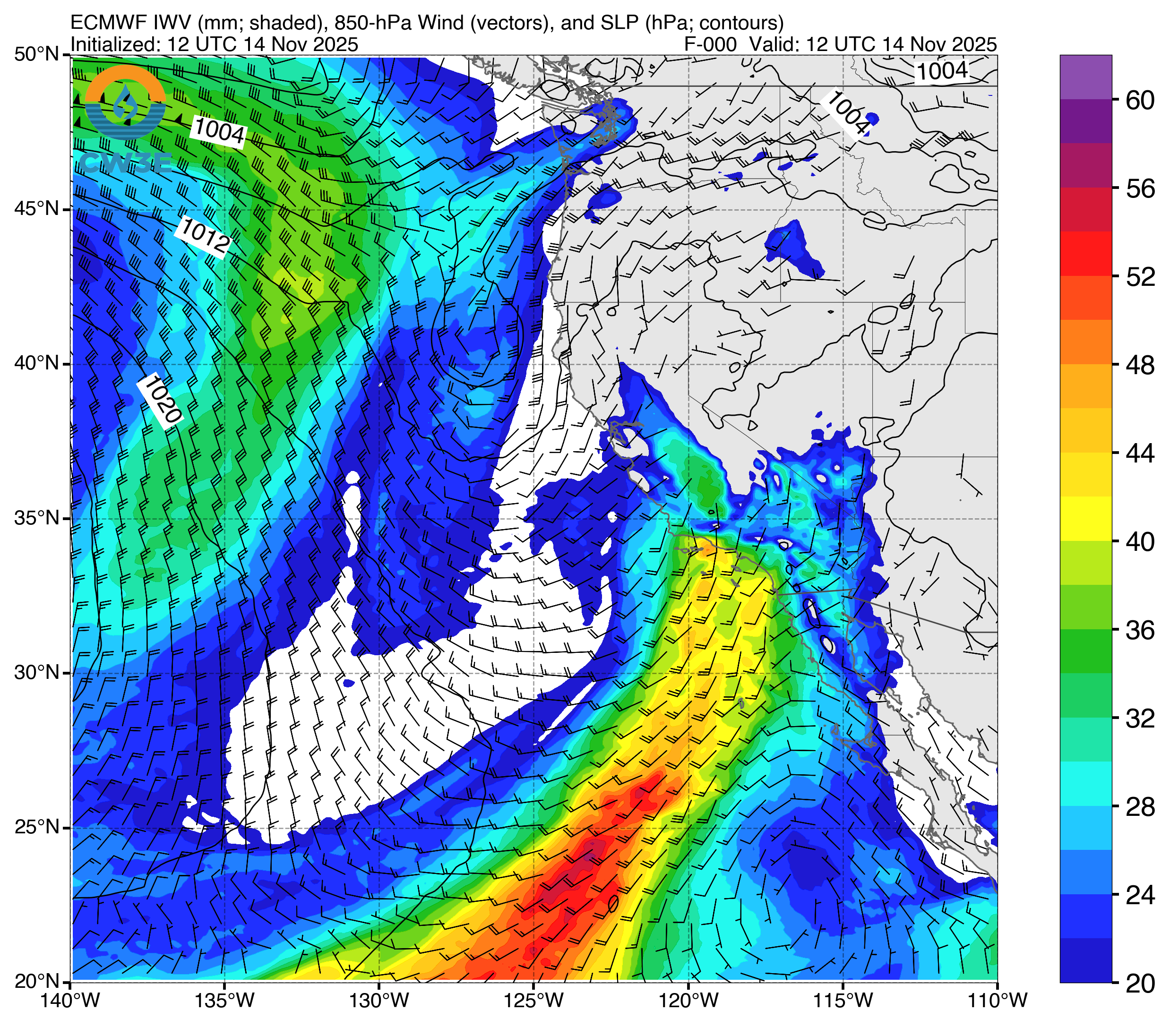
I had not planned to update the blog this week, but the imminent storm slated to affect Southern California tonight into the weekend now appears to be considerably stronger and more potentially threatening (from a flood risk perspective) than it did even a few days ago (hence, this last-minute post!). This system is not originating in the Gulf of Alaska but is instead largely developing “in situ” from the confluence of a very slow-moving low pressure system sitting well to the southwest of the SoCal Coast and a very moist plume of subtropical (partially even deep tropical) moisture that it has entrained. This extremely warm and moist atmospheric river will contain a near-record amount of atmospheric water vapor for November, and will also feature record-breaking integrated vapor transport on its southern flanks west of Baja CA and far southern CA. The exceptional amount of moisture contained in the atmosphere is being boosted by the continued persistence of much warmer-than-average surface ocean temperatures along the coast and well offshore, in addition to the unusual atmospheric wind advection pattern currently in place.
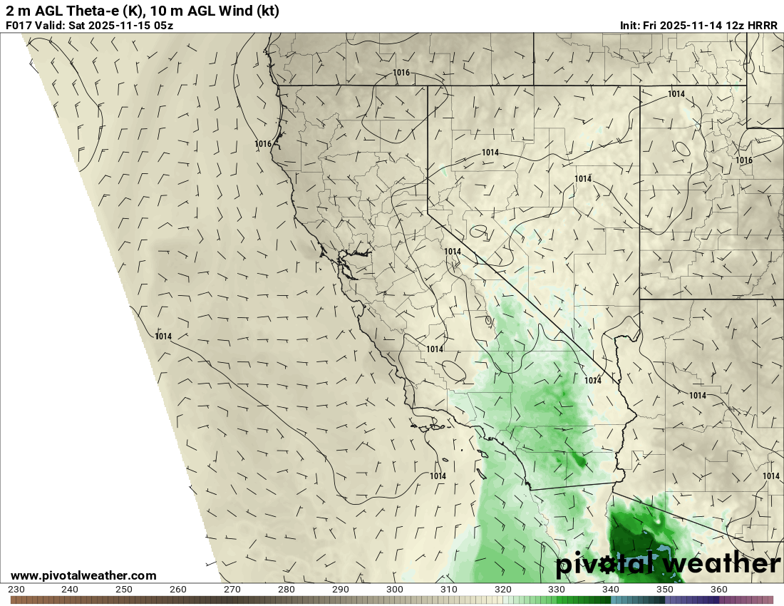
In addition to being extremely moist, the airmass over SoCal will become increasingly convectively unstable in the coming hours, peaking sometime tomorrow. Although CAPE is not particularly notable (generally 200-500 J/kg), the extreme moisture content of this airmass, the presence of multiple surface convergence boundaries, and some decent upper-level support suggest this is a storm that could punch somewhat “above its weight” in the heavy downpour and thunderstorm department. As depicted below in a plot that (to my recollection) I’ve never shared on Weather West before, a distinct region of elevated equivalent potential temperature (and a strong boundary thereof) will be present tomorrow across SoCal–indicative of an unusually energetic airmass thanks to the combination of tropical-like warmth and humidity. In fact, as is discussed at length in the most recent Area Forecast Discussion from the National Weather Service in Oxnard, there is a fairly high potential for isolated to scattered thunderstorms to develop–first in isolated linear swaths overnight, and then embedded within a broader rain shield tomorrow. A few severe thunderstorms are also possible, mainly in the form of low-topped “mini supercells” that aren’t usually well-represented by traditional weather models or convective indices. The main risk would be locally torrential downpours and associated flash flood/debris flow risk (see below), but there could also be some isolated strong convective wind gusts to 60+ mph or even a waterspout/tornadic spin-up or two.
Notably, the airmass in place over SoCal from tonight into tomorrow will be among the “moistest” on record for this time of year, with both column water vapor and integrated vapor transport (i.e., the combination of moisture and low-level wind) at or near record values for mid-November. The fact that these key variables will be so extremely elevated, at or near their historic seasonal maxima, in an environment conducive to both orographic uplift in the foothills and mountains as well as at least isolated deep convective activity–suggests the ceiling on hourly to 6-hourly rainfall accumulations is at least locally very high. Not everyone will see extreme downpours, but at least a few locations probably will, and the highest likelihood during this event does appear to be the very highly populated portion of SoCal from eastern Los Angeles County westward across Ventura County. This region also includes the major 2024/2025 burn areas; the Palisades and Franklin fire footprints in particular will be vulnerable to debris flows this weekend. But fairly widespread urban/street flooding is also possible in these areas, as well as more significant flash flood/debris flow issues in susceptible canyons. Accordingly, Flood Watches are in effect for virtually all of SoCal–and also parts of the southern Sierra and eastern deserts. In fact, some high-res convection-resolving models are depicting a line of torrential rainfall and locally strong/severe thunderstorms lifting northward later on Saturday from the coastal region over the mountains and into the desert regions to the east; I would not be surprised to see yet another major flash flood in Death Valley or in other usually arid settings this weekend.
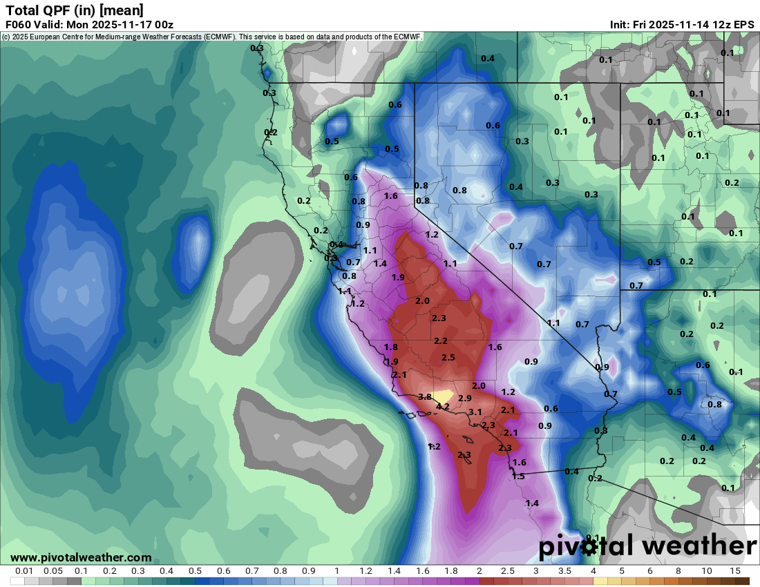
It is worth noting that there has been some online chatter regarding some especially extreme rainfall projections arising from individual model runs (like several consecutive update cycles from the ECMWF yesterday) depicting nearly double the amount of rain near LA (i.e., as much as 8-10 inches just this weekend in LA City proper). That would be a record-breaking amount, and result in substantially greater flood risk than currently indicated. However, this was (and remains) an extreme outlier solution even within the very same model’s broader ensemble. There is certainly strong consensus on a very wet weekend in LA, perhaps problematically so, but the very extreme amounts that were depicted by those individual models runs remain quite unlikely. That said, while the SoCal lowlands will mostly see 2-4 inches of accumulation (with possibly double that in favored orographic areas), there will be some pockets that could be a bit above that range and that’s where urban/flash flooding would be most likely. But in this case, the greater concern is less the total volume but instead how quickly it will fall; in an extremely moist and at least somewhat unstable airmass, local downpours could rapidly overwhelm faster-responding stormwater/drainage systems as well as smaller creeks/streams.
Also, it’s now looking quite likely that Los Angeles will already be guaranteed a top-5 wettest November on record after this weekend’s precipitation; it may climb even farther up the rankings depending on what happens next week.
A wet pattern continues next week, with major uncertainty thereafter due to polar vortex disruption
Well, next week is looking pretty wet as well across all of California! There is considerable uncertainty surrounding the details, and another heavy rain event cannot be ruled out in Southern California (at least light to moderate additional rain is quite likely). It currently looks like two distinct systems (both faster-moving than this weekend’s sluggish low) will swing through, bringing quick bursts of rain/wind and some isolated thunderstorms. Both of these do look somewhat colder than the present storm–which, as mentioned, is quite warm with high snow levels and accumulations only on the highest mountain peaks–and so I would expect better mountain snow accumulations at lower elevations with these subsequent systems later in the week (better news for Sierra snow lovers).
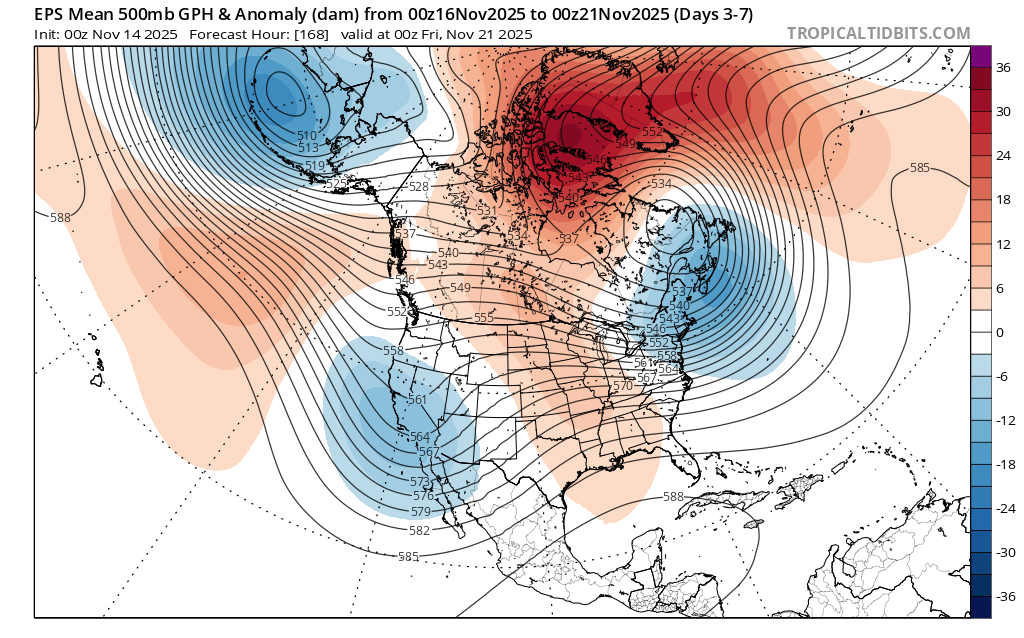
After that, the overall pattern across the Northern Hemisphere will be dominated by strongly blocked in the Arctic and a very wavy midlatitude jet stream–leading to a “stuck” ridge-trough sequence over the Pacific, North America, and Atlantic. One might think this would mean the wet pattern in California would continue, but the models are actually suggesting otherwise at the moment. That’s because they indicate a gradual but critical eastward shift in the entire quasi-stationary wave pattern, and that the upstream Gulf of Alaska ridge will shift just close enough to the CA coast to prevent storms from taking an overwater track and bringing rain/snow to the state. Instead, these systems would dive southward just east of California, keeping the state mostly dry (but cooler) and offering a much-needed opportunity for some Rocky Mountain snowfall (right now, snowpack is near record-low levels in parts of Rockies due to exceptional warmth and dryness in recent days). Whether this is truly the case, or whether a wetter CA pattern continues, depends strongly on this “razor’s edge” prediction regarding the exact latitude of the upstream ridge over the East Pacific.
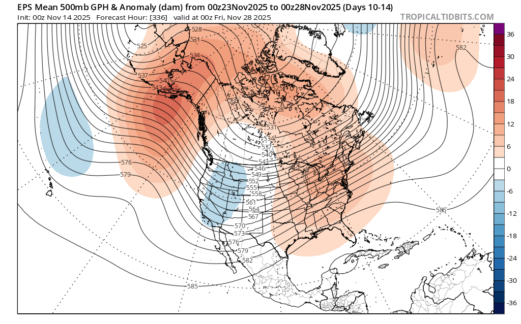
Further complicating the outlook for the rest of November and much of December is that a major polar vortex disruption may occur during this period following a strong “sudden stratospheric warming” event. Such episodes can result in high-latitude blocking (perhaps prolonging what we’re already seeing near Greenland) and reinforce stuck/wavy jet patterns in the midlatitudes. They are often consequential for mid-latitude weather, including in California, but it’s often hard to ascertain the impacts well in advance other than that high-amplitude ridges and troughs are both likely–somewhere over the eastern Pacific–in the weeks to come. The million dollar question is exactly where those will end up. Stay tuned!
My message during COP30: Now is not the time to scale back climate mitigation efforts (quite the opposite!)
I recorded a short video op-ed to help cut through the noise surrounding the ongoing COP30 climate conference. In short: now is not the time to scale back our efforts to address climate change–quite the opposite, as the intensifying consequences have never been clearer. This video arose from a very brief written op-ed piece that was published today, in even more succinct edited form, in Semafor.
YouTube livestream TODAY (Friday, Nov 14 at 4pm PT); possibly another pop-up session tomorrow (Saturday, Nov 15)
I’ll discuss the weekend storm and associated flood threat in Southern California today (Friday) at 4pm PT. See you there!
Discover more from Weather West
Subscribe to get the latest posts sent to your email.