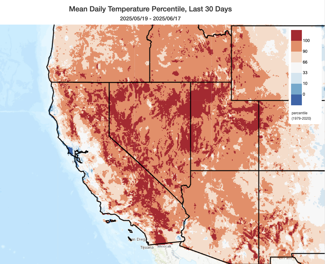
Remarkable contrast, once again, between near-record warmth inland & mountains but near or cooler than average coast in May-June
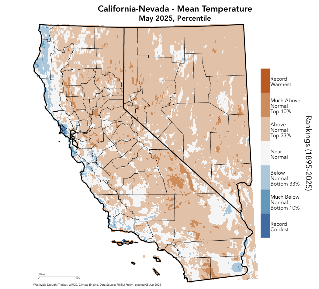
Well, it has happened again: California has experienced yet another late spring period that was exceptionally warm across nearly the entire interior and mountain portion of the state–yet simultaneously unremarkable, or even (locally) notably cooler than average, along the coast. This pattern has arisen this time of year on more than a few occasions over the past decade, and seems to have thrown some folks for a loop (based on the messages in my inbox recently!). And it has been notable in that it has meant that the conditions experienced by the majority of California’s population (which is, largely, within 20-30 miles of the Pacific coast) and conditions occurring across the majority of California’s land area (i.e., inland and at higher elevations) has been markedly different.
To be clear, this is different than the usual/ordinary/(in)famous reality that the California coast is nearly always (except during unusual offshore wind events, usually in autumn) dramatically cooler than regions just 5 or 10 miles inland for most of the summer. That, simply, is due to the presence of a nearby chilly ocean and stable atmosphere above, allowing the cold waters offshore to strongly influence near-shore climate but the heat from (sometimes relentless) summer sun to predominate further inland. That “cool coast, hot valley” pattern is normal, and expected. But this year, and in recent years, the contrast between the coast and inland areas has been even more extreme than was historically typical, with highly anomalous to record-breaking inland warmth opposing near or even below average temperatures along the coast.
Aside from skewing public perception regarding the broader state of California’s climate from the perspective of its coastal denizens, this dipole temperature pattern also has major implications for ecosystems and wildfire conditions. In May and June of this year, exceptional sustained warmth has pervaded most of the more remote and heavily vegetated parts of the state (including the upper slopes of the Coast Ranges, the Sierra Nevada (and its foothills), Klamath, and Shasta Mountains, as well as the mountains and deserts of southern California. Spring was also quite dry in many of these same locations. That combination led to a very early melt-out of high elevation snowpack, and has caused vegetation drying to run 1-2 months ahead of schedule in some locations. Given the expectation of even more intense and widespread heat later this summer (see below), that extra month or two of vegetation drying will heavily factor into burning conditions later this season, especially from August through October (or beyond, depending on when the seasonal rains arrive).
A chilly and windy summer solstice statewide, plus elevated fire weather risk at lower elevations
Despite the recent inland heat, however, and the projection for more to come later this summer–the summer solstice this weekend will actually be notably chilly throughout California and the rest of the West Coast region. An unseasonably deep trough will dive southward, once again, over the Great Basin this weekend, driving another “inside slider”-type low pressure system southeastward east of the Sierra Crest. This system won’t generate any precipitation in California aside from perhaps a *slight* chance of a few showers along the North Coast and northern Sierra, but it will bring drastically cooler and also much windier conditions along with low relative humidity.
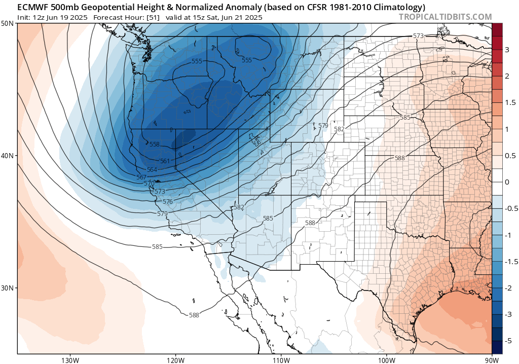
Due to recent anomalous heat inland and the upcoming wind/low RH conditions this weekend across much of California, wildfire risk will be on the increase and Fire Weather Watches have already been posted by the NWS for some areas. Generally, vegetation is not anywhere near peak seasonal dryness, especially at higher elevations, so that should be a major mitigating factor. But inland, and at higher elevations, it is nonetheless drier than usual for mid-June and in places where seasonal grasses have cured (generally up to 2,000 – 4,000 elevation, depending on location), there will be an increase risk of wind-driven fires over the next few days. (There will be little risk of major fires at higher elevations as it’s not dry enough yet). But in the Central Valley, surrounding foothills, and parts of inland SoCal, fire risk will be pretty high over the next few days. In fact, as of this writing, PG&E has already declared some public safety power outages (a few of which may already have been implemented), though I would not expect these to affect a huge number of people as the affected regions are somewhat narrow. All in all, this looks like a pattern with elevated but not extreme fire risk, and it probably won’t affect either higher mountain or coastal zones (mainly the spots in between). It’s worth noting, though, that fire weather risk will be more extreme east of the Sierra Crest, across most of the Great Basin, and eastward into the Central Rockies–where quite a lot of new fire activity will be possible.
A progressive pattern to continue for rest of June; inland areas remain warmer than average most of the time
Following this weekend’s cool trough and wind event, a weak low may linger near California for a few more days keeping things cool into the middle of next week. But thereafter, there are already some signs of another significant heatwave centered on the Pacific Northwest and northern Rockies, with unusually hot temperatures extending across much of the California interior once again (mainly at higher elevations plus the far norther Sacramento/southern San Joaquin valleys, with the coast possibly remaining chilly. Yes, again.) So it does appear that the progressive (i.e., ridge-trough alternating) pattern will continue for at least the next 7-10 days, but warmer than average conditions will continue to win out overall everywhere except for the immediate California coast.
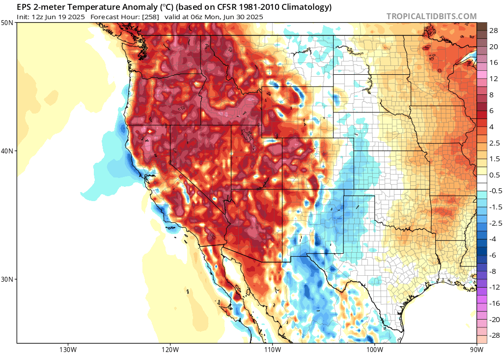
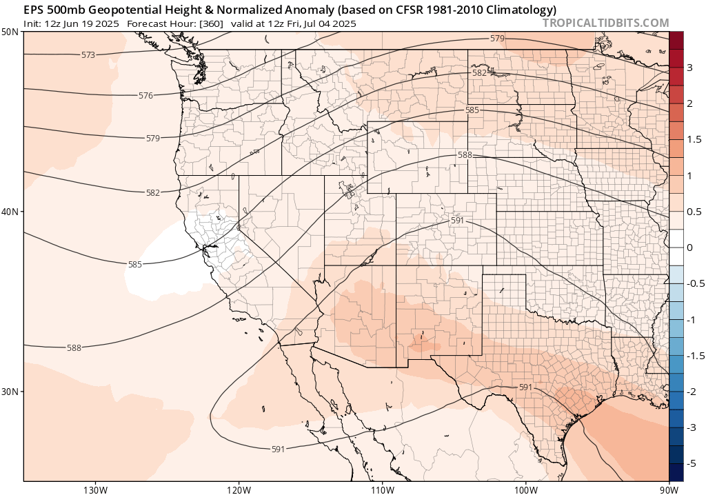
By early July, there aren’t any particularly extreme outcomes currently prominent in the broader ensemble. But diffuse anomalous ridging–across essentially the entire western U.S. domain, as portrayed below, will continue to keep the majority of the West considerably warmer than average. It’s not yet clear when, exactly, the CA coast will start to see anomalously warm weather (and it might take much of July to get there). But in the meantime, it’s likely that much of interior and higher elevation California will end up with a top-3 warmest May-June period on record (once again) while the coast remains, comparatively, quite chill(y).
Summer and autumn update: All signs continue to point toward remarkably hot summer across essentially entire U.S. West
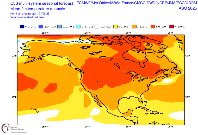
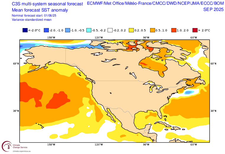
As previously noted, all signs point to (very?) hot this summer beginning in July and progressively expanding closer to the coast by Aug-Oct. There is near-unanimity across large seasonal predictive ensembles of an exceptionally hot summer across most of the interior of North America, including the U.S. and Canada, and that this heat will expand westward later this summer to encompass the entire West Coast (including coastal California, and even offshore waters). In fact, current ocean model projections suggest that by September the entire northeastern Pacific Ocean itself will be much warmer than average–even including the immediate offshore waters of California. This would be pretty different than recent summers where unusually warm water has stayed well west of the immediate coast, keeping near-shore communities comparatively cooler. That protective effect seems likely to fade later this summer, potentially setting up a pattern that is much warmer at the coast than recent summers and weakening the present dipole pattern.
All of this adds to an already fairly ominous wildfire outlook for the Western U.S. and Canada this summer and fall due to a combination of antecedent drought (in some places), rapid mountain snow meltout this spring (widespread across the West), exceptional projected heat from Jul-Oct, and drier than average conditions across much of the northern tier of the U.S. West and western Canada later this summer. One potentially brighter spot may be signs of a near to (maybe even wetter than average) monsoon later this summer in Arizona or New Mexico, but that’s unlikely to provide much relief further west and north at the peak of fire season. But there is also the extenuating circumstance of chaos in the federal government agencies, departments, and entities that prepare for and respond to disasters–including wildfires–that may come at an especially inopportune time. We’re not there yet, at least in the U.S. (fire season in Canada is already tracking to be the 2nd worst on record), but there is growing concern
For your consideration: My recent commentary on dams in the American West and their future in a warming climate
In this 8-minute monologue recorded for the University of Southern California (USC) 20th Anniversary Conference on Dams in May 2025, I reflect on how dams have been both a blessing and a curse in the American West–successfully buffering against the extremes of drought and flood and facilitating reliable water supplies for cities and agriculture, but also causing environmental harm and even posing new hazards unto themselves. I share my view that observed and projected shifts in Western hydroclimate will likely further accentuate that duality in a warming world.
New livestream to discuss recent/upcoming weather & updated summer outlook: Friday, Jun 20, 1pm PT
I’ll discuss the recent pattern of exceptional inland warmth but notable coastal coolness, and the broader implications of this “anomalous temperature dipole.” Also, I’ll take a look at the (relatively chilly and windy!) summer solstice forecast, elevated fire weather conditions this weekend, and the (very hot and potentially fiery!) updated outlook for the rest of summer and autumn. See you then.
Discover more from Weather West
Subscribe to get the latest posts sent to your email.