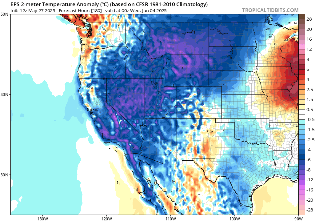
Rapid warm-up Thu-Sat, with daily to monthly records possible across interior NorCal
Well, here comes the roller coaster! The next 2 weeks will feature a wide array of active, unusual, and highly changeable weather conditions across California and the broader West. It would, I think, be fair to call the upcoming pattern one characterized by rather dramatic weather whiplash–from record hot in NorCal on Fri-Sat to windy, cool, and even showery by Tuesday (on top of some isolated SoCal thunderstorms this weekend?) only to be followed, immediately, by another episode of potentially widespread anomalous heat. Something for everyone, I suppose, but certainly not typical June weather in this part of the world!
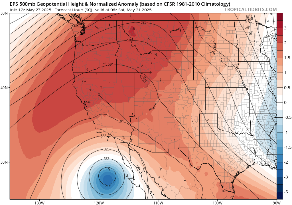
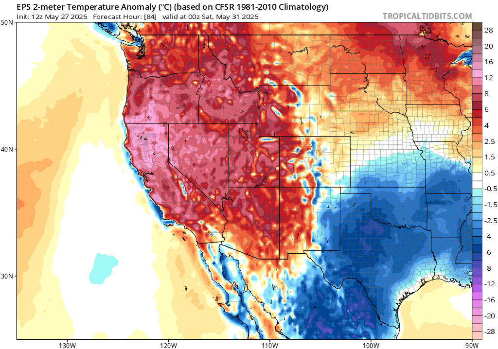
A very strong ridge will build rapidly by Thursday along the West Coast from central California northward into the Pacific Northwest interior, peaking at record strength (for late May) on Fri/Sat. Meanwhile, a notable low pressure system will develop directly south of California–forming what is known as a “Rex Block” pattern. As it does so, Northern CA will experience rapid warming to well above average and in some cases record-breaking levels by Friday. Widespread daily record highs will probably be set across most of interior northern and central CA on Fri/Sat, with even a handful of all-time monthly records possible in hotter parts of the Sacramento Valley and surrounding foothills (including Redding at ~110F). It’ll be pretty hot in SoCal, too, but probably not record warm, and just how close to the coast the heat will get in NorCal is still somewhat uncertain (although even just a few miles inland, it’ll get very hot indeed). Widespread Heat Advisory products are out from the NWS for much of NorCal during this event.
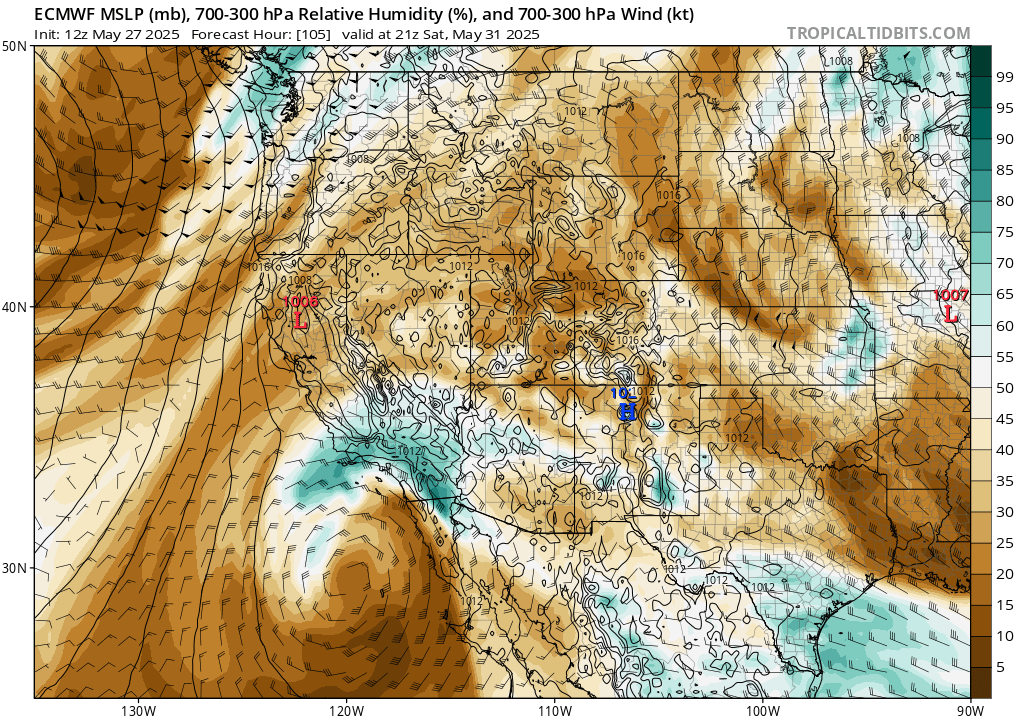
Meanwhile, the incipient low pressure system will drift northward, closer to the coast of SoCal, by Saturday and will entrain some moisture from a soon-to-develop tropical storm off the west coast of Mexico. There is significant uncertainty regarding the exact track of the low and the amount of moisture entrainment/resultant elevated instability that may have pretty big implications for SoCal weather this weekend. But it does appear there’s at least a slight chance of a few showers and thunderstorms across much of SoCal, including coastal areas this weekend (and, less likely, northward across portions of central CA). The range of possible outcomes is from essentially nothing more than some pretty mid-level clouds to a more widespread thunderstorm outbreak. Although we remain nowhere close to peak seasonal vegetation dryness, even in SoCal, if there is any lightning it would probably be associated with relatively sparse precipitation and could spark a few wildfires (mainly in grass and brush, given the earliness of the season). I am not currently overly concerned regarding a more widespread lightning-sparked fire outbreak for a variety of factors related to both the meteorological setup and the state of the background vegetation on Jun 1, but it’s certainly worth watching heading into the weekend. Meanwhile, in NorCal, the pace of grass fire events will probably continue to increase and there may also be some activity in heavier fuels (outside higher elevation forests, which are still too damp) as things further heat up and dry out.
Then…an even more rapid cool-down Sun-Mon as anomalous late season lows bring strong winds & possible showers/thunderstorms
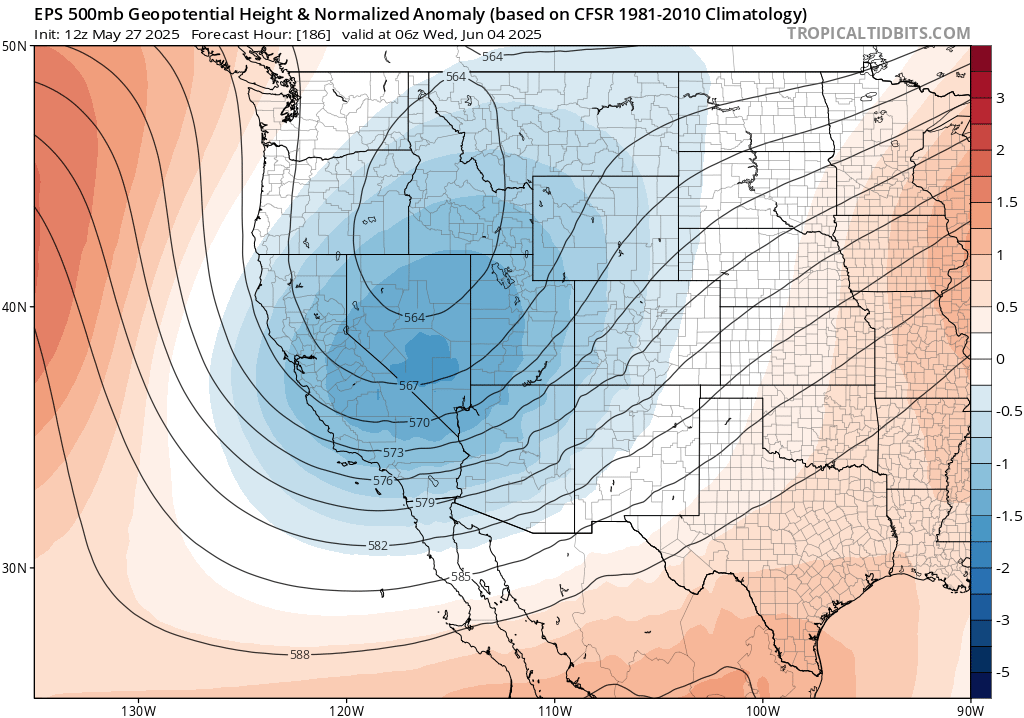
Then, by Sunday or Monday, the record-strength ridge will rapidly be replaced by a pronounced (though transient) trough and associated low pressure system that will likely slide southeastward across NorCal and the Great Basin. Here, too, there is meaningful positional uncertainty that will dictate whether this is a minor or more notable event from a precipitation perspective. But it appears very likely that, at a minimum, temperatures will fall dramatically and it will get windy (perhaps very windy) across most of California during this period with at least a few Sierra Nevada showers. If the low takes a more western track, it’s possible that some more widespread showers and isolated thunderstorms could occur across northern/central CA (even in coastal areas); if it “threads the needle,” there could instead be some localized significant fire weather concerns as strong north winds/very dry air follows the brief but intense heatwave over the weekend in grass/brush-covered regions. Either way, though, the temperature contrast from Fri to Tue (or even Sat to Mon) will be quite dramatic by California June standards.
And then…a return to hot conditions immediately thereafter?
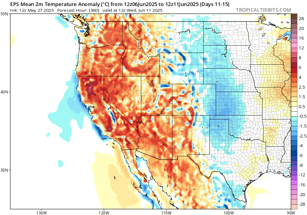
And once we get past the middle of next week? Well, it looks like things will probably heat up again essentially statewide (and beyond) as a broader ridge rebuilds; ensembles suggest a good chance of hotter-than-average temperatures again by Jun 7/8. If this occurs, it would result in yet another dramatic temperature shift (from very hot to quite cool to hot again) over a span of just 10 days. Quite some conditions during a month more typically characterized by a stable marine layer at the coast as its most recognizable feature!
Weather West livestream to discuss the upcoming weather whiplash: Wed, May 28, at 3pm PT
I’ll talk about the upcoming period of weather whiplash, including the record heat-to-cool/windy/showers-and-back-again sequence, during my next YouTube livestream at 3pm PT on Wednesday May 28th. See you then!
Join me live on Saturday evening for a special virtual event: “100 Hours to Save America’s Forecasts”
In addition to the semi-regular livestream on my Weather West YouTube noted above, I’ll also be participating in a special live virtual event that’s beginning this Wednesday (May 28th) and continuing (continuously) through Sunday evening (June 1). The event–which has been organized by scientists around the country in response to the rapid, chaotic, and still-expanding cuts to and upheaval within federal weather and climate science (and operations)–will feature talks and presentations from a veritable litany of weather, climate, and Earth science luminaries over a 5 day period. Current and recently fired NOAA/NASA scientists, multiple former National Weather Service directors, the president of the American Meteorological Society, atmospheric scientists from over 10 American universities, Jeff Masters (of Weather Underground) will all make appearances, and I’ll be hosting a live “Ask Me Anything” session at 6:30pm Pacific Time on Saturday, May 31. The primary aim of the event will be to showcase the critical importance of publicly-funded weather and climate science in the United States, how there presently exists no alternative of comparable scope or scale anywhere else in the world, and the enormous consequences for American life (including the economy) if we continue on a path toward losing much (or most) of it. I hope you’ll join me here as well.
Discover more from Weather West
Subscribe to get the latest posts sent to your email.