It’s official: California’s north-south precipitation dipole persisted the entire wet season
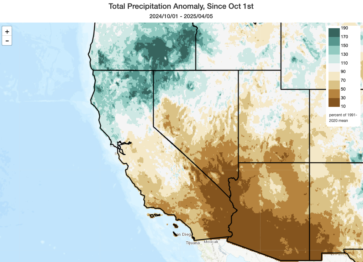
Well, as the dry season approaches, it’s now pretty clear that the much-discussed north-south “precipitation dipole” across California did indeed manage to persist for the entire rainy season (something that had been predicted by seasonal outlooks). It did soften, somewhat, from its very intense iteration that peaked in January (with record wet conditions across portions of NorCal and record dry across nearly all of SoCal) as meaningful rainfall did eventually return to the south later in the season. But the first half of the rainy season was so extremely dry in SoCal, and was not counterbalanced by exceptionally wet second half, that seasonal deficits remain large. In fact, most of Los Angeles, Ventura, and Santa Barbara counties now appear likely to finish the season at less than 50% of average precipitation, and all of SoCal (plus the Central Coast) will likely finish below average.
And this dipole actually extends to beyond California: much of Oregon, especially southern and eastern parts of the state east of the Cascades, are now wrapping up an exceptionally wet season. Meanwhile, much of the interior Southwest–and in particular the lower Colorado basin including Arizona, southern Nevada and Utah, and western New Mexico–experienced (another) exceptionally dry winter (record dry in some cases, with under 30% of average precipitation across a wide region).
Despite all of this, Sierra Nevada snowpack is in pretty good shape. The statewide percent of average snow water equivalent (SWE) is hovering right around 100% of average–a seemingly picture perfect value. The details, however, are a bit more complicated: that statewide number encompasses solidly above average snowpack in the northern end of the mountain chain (~125% of average) to below in the southern (~85% of average), and above average snow at higher elevations but below average snowpack at lower elevations. Overall, though, this solid April SWE (combined with essentially at-capacity reservoirs in most cases, thanks to now 3 consecutive near-to-above average precip years on the Sierra west slope) is good news from a CA water supply perspective (i.e., there are no major concerns for the next year or so even if things subsequently dry out).
Additionally, and as I think has been missed in some of the reporting in recent years on California snowpack, it is worth noting that CA DWR’s snowpack “normals” are themselves a victim of “shifting baseline syndrome” in a warming climate. The average currently used for this purpose was calculated using the 1991-2020 period–a 30 year window in which snowpack overall notably declined in California (by ~15-25%) and which also featured the lowest single snowpack years on record. So in other words: the “average” snowpack ain’t what it used to be, and 100% of an average 1991-2020 snowpack is actually less than 100% of average of, say, a 1900-1990 snowpack. Using a more recent averaging window is not a “problem,” per se, since a lot of the time what folks really care about is how this year’s water year compares to recent experience. But from an ecosystem and water supply perspective especially, using only recent baseline years in a non-stationary and rapidly warming climate may obscure important longer-term trends.
Cool and unsettled pattern as of late is rapidly fading, with persistently warmer and drier conditions to come
A bit of additional rain in Northern California may be the last meaningful precipitation across most of California for quite some time. Mid April is often when precipitation begins to taper off pretty rapidly, especially across central and southern parts of the state, though there is high variability between years (in that late spring can, on occasion, either be quite wet or quite dry). Looking forward, it certainly looks like the spring is going to be much drier and warmer from here on out–not just across California, but probably also the broader Southwest.
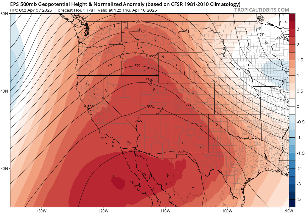
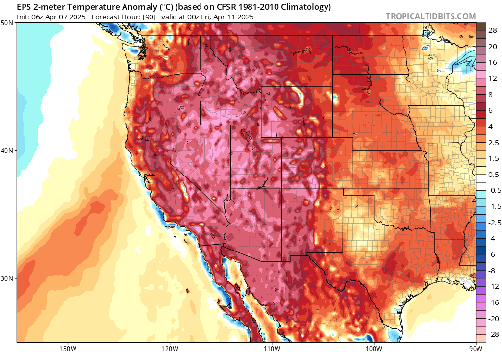
Later this week, a strong but somewhat transient ridge will build over Baja CA and the interior West. This will bring a period of early season heat across nearly the entire West, though it will be most anomalous across the interior (including the mountains and deserts of eastern CA, but especially across the Great Basin and interior SW deserts). Some daily record highs will be possible on Wed/Thu, mainly across the CA interior and points east, but it will feel pretty warm nearly everywhere else as well.
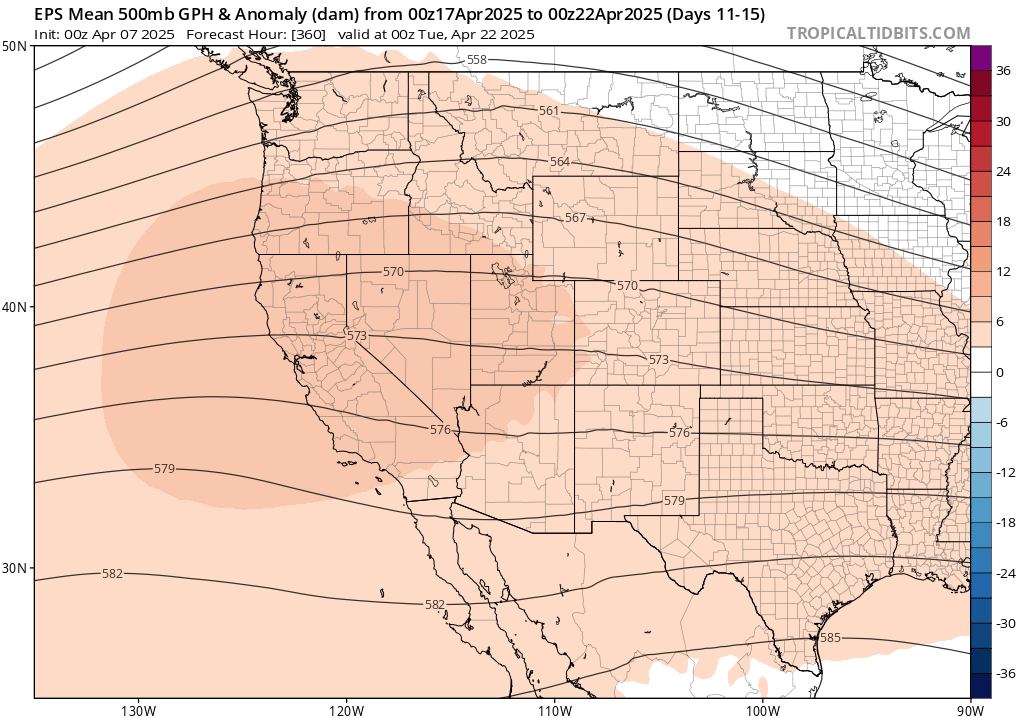
After this week, this brief ridge will probably weaken but not break down entirely (a few breakthrough showers may be possible at that point across far NorCal, but that’s about it). Thereafter, there is decent ensemble agreement that a broader and perhaps more persistent ridge will build back once again, this time centered more along the West Coast, heading into late April. Warmer than average temperatures will probably occur during this window, as well, and may make it closer to the coast vs later this week. Little or no rain is expected across California during this period, especially across central and southern portions of the state.
Strong hints of a notably warm and dry remainder of spring and early summer across CA & broader West
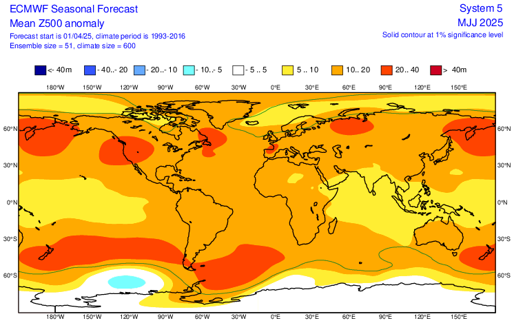
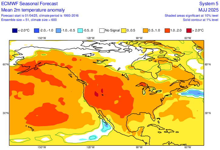
I’ve discussed on recent livestreams the elevated potential for an unusually abrupt transition to much warmer and drier conditions this spring across CA, and that does seem to be playing out this month. The just-released ECMWF seasonal ensemble predictions only underscore this possibility (see images above and below). While the full multi-model ensemble data for the April update cycle won’t be available for a few more days, the ECMWF ensemble paints a striking picture of a very hot end to spring and start to summer (May-Jul) across the entire U.S. West–including California. In fact, this is one of the hottest early season temperature signals I’ve ever seen from the ECMWF at seasonal scales, and it extends all the way to the CA coast (unlike in recent years, when seasonal outlooks clearly offered a “coastal carve out” that did indeed materialize).
All of this is underpinned by an equally striking pattern of anomalous ridging at various longitudes throughout the mid-latitude Northern Hemisphere during May-Jul–including one centered directly over the West Coast and California. Locally, this region is actually the location of a climatologically favored weak trough in early summer, so this strong ridge signal may actually equate to “absence of mean west coast trough” as opposed to an actual ridge most of the time during this period. Nonetheless: this is an eyebrow-raising pattern because it would greatly increase the likelihood and severity of early season heatwaves, and possibly also offer less of a coastal reprieve than is common along the often chilly CA coastline during the “May Gray/June Gloom” period due to weaker coast-parallel (northwesterly) winds and thus reduced cold water upwelling. Will this fairly bold prediction by the ECMWF seasonal model bear out? Well, it’s broadly consistent with what the broader seasonal predictive ensemble was suggesting at last update (in March), so it will be interesting how the next update looks in a few days. But my own expectation is that the rest of spring, and probably also the early summer period, will be notably hot across the West and that anomalous heat may well extend closer to the coast than in recent summers.
All of this, of course, has significant implications for wildfire risk and drought expansion across the Southwest this spring and summer. I’ll have more to say about that in a future blog post (and in my YouTube livestreams), but big picture is this: I expect an early (re)emergence of fire season across SoCal (due to a very dry winter following two wet years with abundant grass growth), a delayed fire season emergence across NorCal (with an extended favorable prescribed burning window!) but with a potential very active year in grassier/brushier settings beginning in Jul or Aug due to another wet winter being followed by a (potentially) exceptionally hot summer; an early and severe start to fire season across the interior Southwest (especially AZ and western NM), and a re-intensification of severe to extreme drought across the Lower Colorado basin heading into monsoon season. More to come, later, on all of that.
In case you missed it: My latest “Ask Me Anything” live session
With slightly quieter weather conditions in California recently, I was able to host another “ask me anything” edition of my recurring weather & climate “virtual office hours” sessions on YouTube last week. In case you missed it, this livestream (like all others!) was recorded and is now available for viewing. I’ll continue to host more of these “ask me anything” sessions periodically during quieter periods, with more topically-focused stream the rest of the time. Join me at the next one!
Discover more from Weather West
Subscribe to get the latest posts sent to your email.