NorCal January dry spell ends on last day of the month; much quieter wildfire conditions have emerged in SoCal
We have, finally, seen a week with minimal wildfire activity in Southern California due to recent rainfall (and mountain snowfall, resulting in some rather dramatic “before and after” images (see below) ). And although the last system did not bring much, if any, precipitation to northern California, a new system today is “delivering the goods,” with more on the way. Hopefully, this gives some many folks a reprieve from what has been a very intense period of highly unusual wildfire risk (both latent and realized) across southern California. On that note: stay tuned for a rapid-response publication on that front in Global Change Biology that my colleagues and I have spun up in the last few weeks; publication date remains TBD, but will likely be in February.
The full toll of the Palisades and Eaton fires in Los Angeles County is, now, more clearly apparent. As of this writing, 29 deaths have been directly attributed to the fires (and estimates are that hundreds, and even thousands more, could eventually result from the smoke, toxic exposures, and physical/emotional stress of the aftermath). Around 19,000 structures were damaged or destroyed–most of them homes, collectively housing tens of thousands of people. Urgent questions are already swirling about how the insurance industry will respond, as well as how (or whether, in some areas) to rebuild. The cause of both fires remains officially undetermined, and may remain that way for some time to come (though there is no evidence of arson, despite widespread claims to the contrary); there is some circumstantial but unconfirmed evidence to suggest that power infrastructure (in this case, high-tension electrical transmission lines) may be implicated in the ignition culminating in the Eaton Fire (yet again).
It is often helpful, in the wake of such exceptional disaster and tragedy, to keep in mind the broad view. Wildfire is an inherently natural process, and its effects vary along a wide spectrum from dangerous and destructive (when they directly intersect, with great speed and/or intensity, with populated areas) to beneficial and restorative across a wide range of ecosystems (and, accordingly, fire frequencies and intensities). Remarkably, in the very same month that such devastating fires enveloped densely populated neighborhoods in LA County amid an exceptional wet-to-dry “hydroclimate whiplash” episode, conditions across much of Northern California (amid a lengthy dry spell but following heavy rain just a month earlier) were highly conducive for (risk-reducing) prescribed burns to take place–and many did! Among other things, this illustrates the importance of nuance in conversations surrounding wildfire in general–and also how embracing that complexity becomes even more important on a warming Earth.
For those interested in listening to a long-form conversation expanding on these wildfire-related reflections, I encourage you to check out my recent interview shared on both the California Sun and WhoWhatWhy podcasts.
Very moist (and initially quite warm) atmospheric river(s) to soak NorCal and bring some (initially limited) flood risk
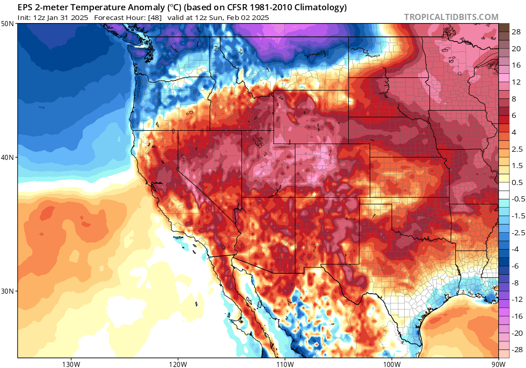
A warm atmospheric river is already draped across Northern California today, bringing widespread (albeit mainly light) rain. Some pockets of snow are still falling to lower elevations in the mountains as cold air remains trapped in pockets, but as the strong warm air advection and subtropical moisture connections strengthen over the next 48 hours, temperatures will rise and snow levels will rise dramatically to well above pass level. Thus, most of the coming precipitation will fall as rain (rather than snow) up to around 7,000 feet in elevation, though temperatures will plummet on the back end of the storm toward the middle of next week and much heavier snowfall will likely accumulate then (and to much lower elevations).
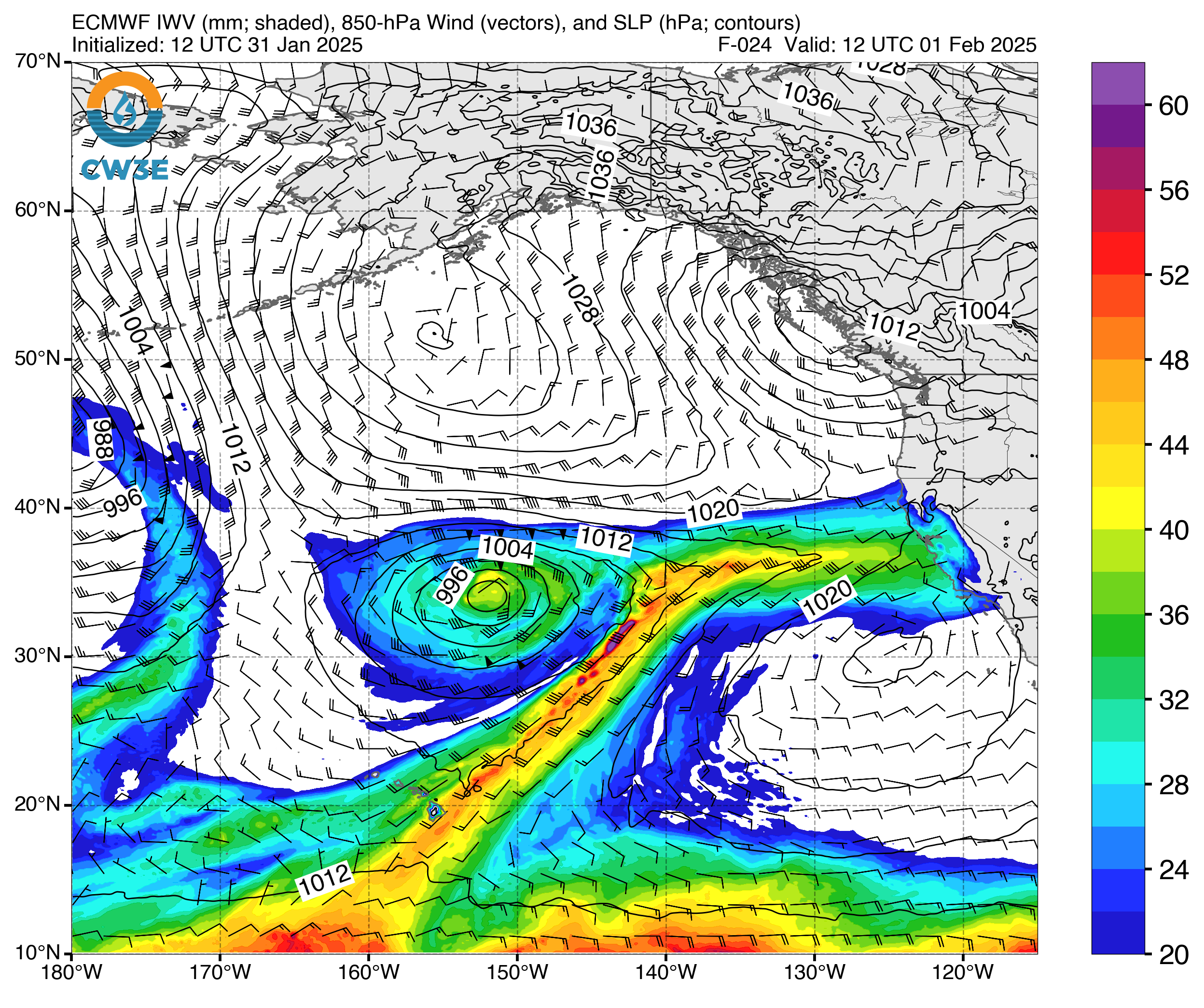
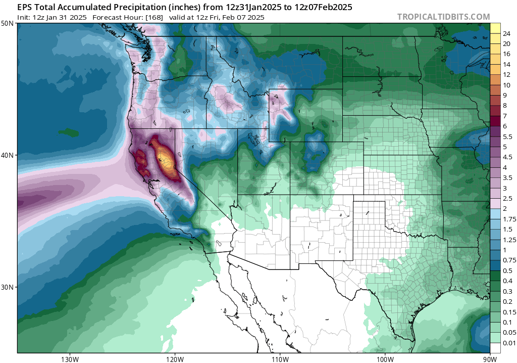
This atmospheric river storm will be of the “Pineapple Express” variety, with a clear connection to a deep subtropical moisture source near Hawaii. In fact, AR Cat-4 conditions are already technically ongoing over NorCal, indicative of a “strong” atmospheric river. Why does it not “feel” like a strong AR at this point, then? Well, there is almost no large-scale forcing (i.e., strong upward vertical motion induced by a low pressure system or a strong front). Instead, a very moist plume is being transported by fairly strong winds aloft in an environment where the majority of precipitation is being generated by “orographic lifting”–upward-motion induced by the Coast Ranges and Sierra Nevada as moist west-to-east blowing air is forced upward on the mountain ranges’ windward slopes (generating enhanced upslope rainfall there). In the Bay Area and Central Valley, precipitation has been pretty gentle and will likely remain so most of the time until a fairly robust cold front arrives on Monday. Until then, light to moderate rain will continue across the NorCal lower elevations almost continuously, with moderate to heavy rain almost continuous on the windward slopes of NorCal mountain ranges. This will allow precipitation to accumulate to impressive levels over the northern and central Sierra–locally upward of 10-15 inches of liquid equivalent (locally higher) over the next 3-5 days (most of which will indeed fall as rain), with about a third of that at lower elevations.
Despite these prodigious precipitation totals, I expect only modest flood risk from this event if it unfolds as currently depicted. There are several reasons for this: 1) The last month has been anomalously dry, leaving soil capable of absorbing at least a couple of inches of precipitation initially, and also meaning that rivers have a lot of room to rise. 2) Precipitation intensities generally do not look super high; this will be more of a “longer and gentler” event versus a “short and sharp” one in most places (except possibly for a brief period around the time of cold frontal passage on Mon/Tue). 3) This is also a strongly orographic precipitation event, meaning that the watersheds which will see the most rainfall are precisely those most accustomed to seeing lots of water. There are, to be clear, Flood Watches out from the NWS across much of NorCal for the next few days–but these are mostly for minor urban street/creek flooding vs mainstem river flooding or more serious urban flash flooding. So, overall, I do not think this is a particularly concerning atmospheric river event in the scheme of things (and compared to many in recent years). There is enough subtropical moisture in the mix that this could become a more serious flood threat, locally, if the AR does stall out longer than expected over a smaller watershed (always a small but nonzero possibility in these scenarios). But right now, that outcome does not appear especially likely.
Some gusty winds will be possible at times during this storm sequence, but here too I am not anticipating anything too dramatic or damaging at the moment.
As noted: continued unstable weather conditions beyond Tuesday will keep showers and lower snow levels (maybe down to 2,000 feet or locally lower in far NorCal) and maybe some isolated thunderstorms around into late week. There are a handful of ensemble members that generate more significant storms toward mid Feb in NorCal, but most indicate a drying trend and a relatively unremarkable pattern during that period (which, given recent events, would be a good thing!).
Some additional rainfall now likely in SoCal, but amount and southward extent highly uncertain
It does now appear that at least some rain will be likely early next week across much of SoCal, especially from LA County northward, as the cold front finally sweeps through. The ECMWF ensemble is notably wetter than the GFS ensemble at the moment, and I would slightly lean toward it. Thus, there is a good chance of another soaking rainfall from at least Los Angeles northward by Tue or Wed, which would be good news from a continued fire risk mitigation perspective. Less rain is likely down toward San Diego. There is a notably wide range of outcomes still plausible, from the nearly dry members of the GFS to a handful of very wet members of the ECMWF. Generally speaking, flood risk will likely remain low from this event in SoCal except possibly in recent wildfire burn areas, and even then only if the wetter outlying members come to fruition. This is likely to be a primarily beneficial rain event for SoCal, as well.
Strong north-south “precipitation dipole” appears likely to persist rest of winter across California
I know anxiety has been running high, particularly in southern California, following January’s historic and catastrophic wildfire events. Even across northern California, folks have been a bit uncomfortable with a nearly month-long dry spell–longer than the “typical” 10-15 day mid-winter dry spell that is common up north, but still far from unprecedented, and also coming on the heels of a very wet Nov-Dec period. Overall, the weather over the next 10 days appears more beneficial than harmful, with a whole lot of rain in NorCal (and maybe some flooding, but likely nothing serious) and at least some additional rain in SoCal (where any precipitation is still desperately needed, since this will only be the second modest precipitation event of the entire season thus far).
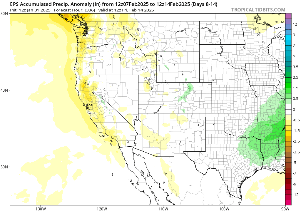
Looking later into February and beyond, there remain pretty strong indications that the north-south “precipitation dipole” that emerged in November and is now making its presence known again this weekend will probably persist (more often than not) for the rest of the California wet season. Odds favor continued near to above average precipitation across the northern third of California and below average precipitation across the southern third (perhaps well below average). Given a pattern that appears favorable for some colder storms later in Feb and Mar, we may see some decent Sierra snowpack accumulation yet to come even if this week’s storms are mainly rain at higher elevations (which seems likely). In fact, I don’t see a particularly warm signal for the next 30-60 days at the moment; California may end up experiencing temperatures close to or even slightly below the recent mid-winter baseline during this period (though it’s important to note that, due to “shifting baseline syndrome” in a warming world, that’s still warmer than it used to be).
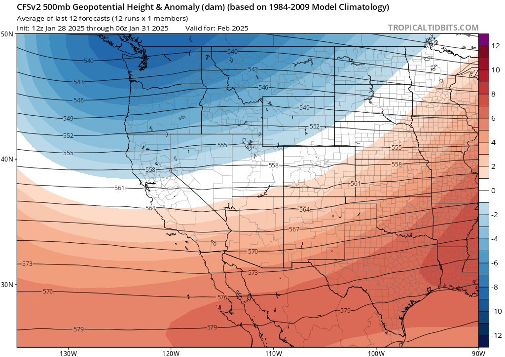
However, there is a broader tilt in the odds toward a potentially much warmer than average late spring and early summer period across most/all of California and the Southwest U.S. This, combined with a continued signal for below average precipitation during this period across southern California and also most of the lower Colorado River basin to the east, suggests that drought will likely emerge, persist, or intensify (depending on current status) from spring into summer across this region. This probably means an early “start” to fire season in SoCal and the Desert Southwest in 2025. Meanwhile, in Northern California and the Pacific Northwest, it’s quite plausible the opposite could be true (i.e., there could be a later start to fire season the farther north one goes along the Pacific Coast, though the warm signal for spring is presently widespread and that might speed things up a bit relative to what might occur otherwise). For what it’s worth, this overall pattern is certainly reminiscent of one that might be expected during a moderate “relative La Nina” year superimposed atop long-term climate trends.
Discover more from Weather West
Subscribe to get the latest posts sent to your email.