After cooler and wetter mid-Aug reprieve (in NorCal & PacNW), hot weather returns
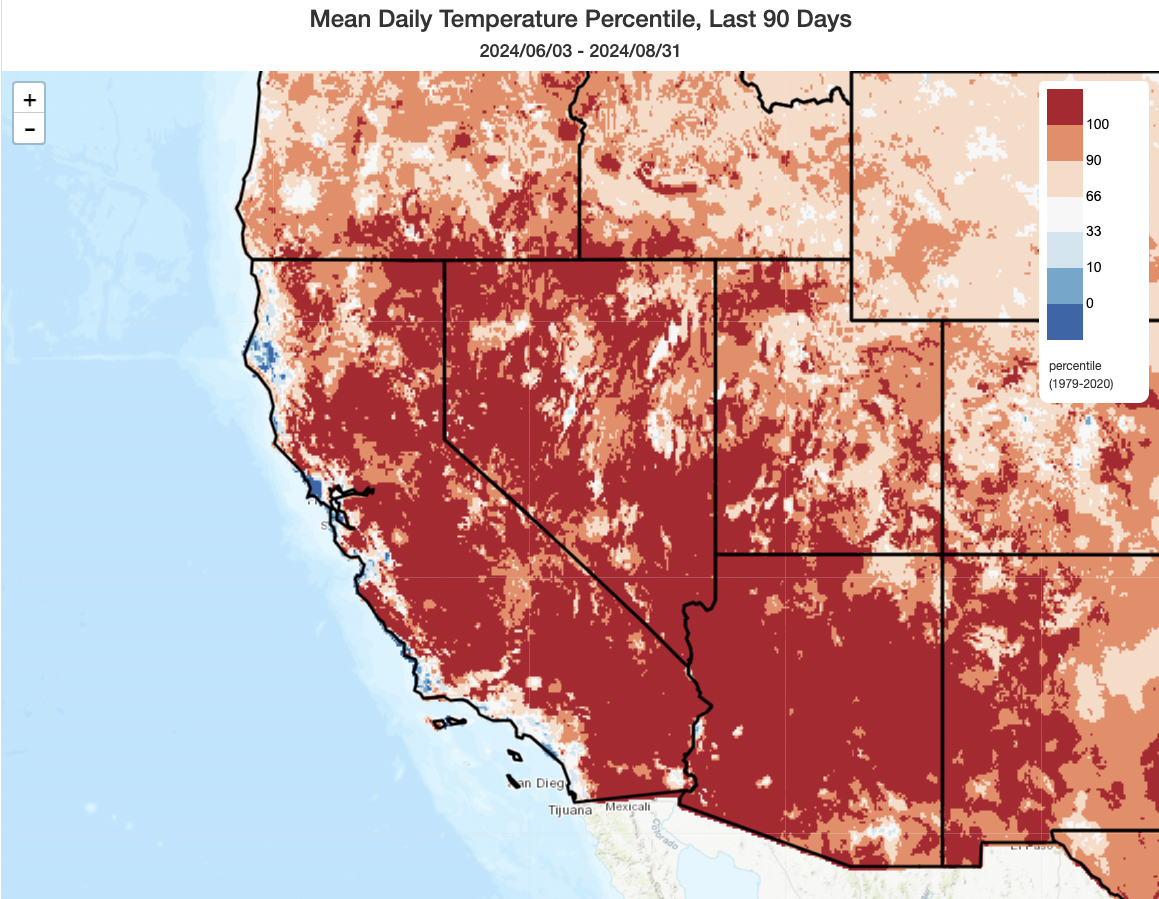
Well, it’s not official yet–but when the formal NOAA statistics come out later this week, it’s quite likely that Summer 2024 will be deemed the hottest on record across much or most of the American Southwest, perhaps including Arizona, Nevada, California, and maybe Utah at a statewide level. Although not official, the regions painted in dark red in the map plot above should give a general sense of how widespread the record-breaking heat was this summer. And it wasn’t universal: In fact, most of California’s immediate coastline missed out on record heat this season (including some of the most densely populated portions of the SoCal megalopolis)–meaning that while a majority of California’s land area did indeed just experience a record-hot summer, the majority of California’s population likely did not (a pattern we’ve seen repeated in several recent years). The millions of folks living in and near Las Vegas and Phoenix, however, were not so lucky.
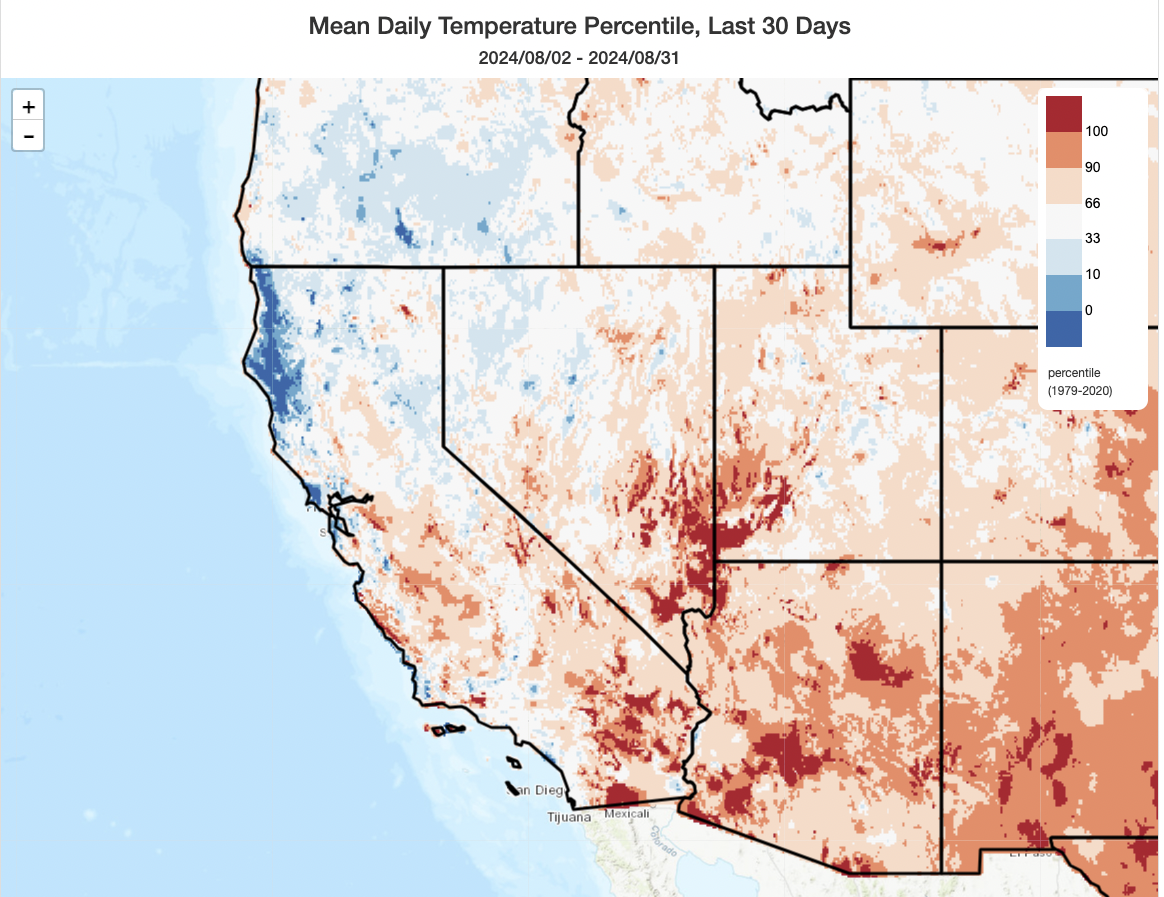
These record warm summer stats are all the more remarkable when one considers the month of August in isolation: generally, it was not an especially hot month across much of California. Conditions were actually much cooler than average in August along the North Coast (where rare bouts of August rain also fell). Conditions were much warmer in SoCal and especially in the SE CA deserts as well as the lower deserts of NV, UT, and AZ–where August too was record-breaking (or nearly so) from a heat perspective. But my point is this: June and July were so persistently and extremely hot across most of California that the summer will likely officially end up as the hottest on record despite an August that featured near to even below average temperatures in many areas. That is genuinely remarkable.
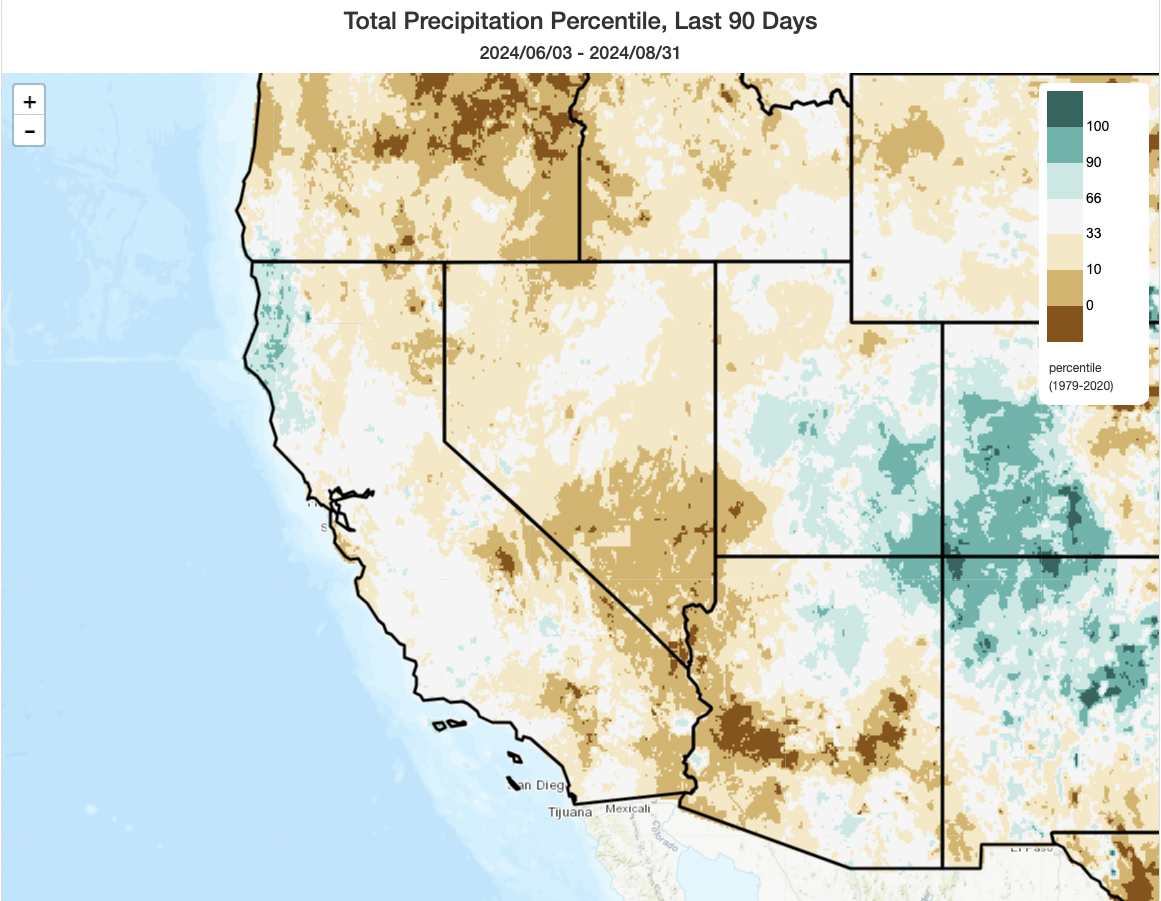
Although August is typically the driest month of the year across much of lower elevation and coastal California, it’s sometimes a rather active month in far eastern CA and in parts of SoCal due to the summer monsoon–which brings occasional but sometimes powerful and very wet thunderstorms to the Mojave Desert and mountains to the West. In 2024, the monsoon was a near no-show on its western flank. Monsoon 2024 summer precipitation was well below average in all California regions that usually see some summer thunderstorms, and also across the entire Great Basin and lower AZ deserts to the east. That’s in great contrast to the Four Corners–which saw exceptional and even locally record-breaking monsoon precipitation this year (including deadly and destructive flash flooding). But overall, SE CA, NV, and southern AZ did quite poorly and saw yet another summer with a combination of record-breaking heat and less than usual relief from summer downpours. Also notable on the summer precipitation anomaly map is the North Coast of CA, which experienced rare significant August precipitation on at least two occasions and therefore ended up with well above average summer precipitation in 2024.
Major West Coast heatwave this week, with some (daily) records possible
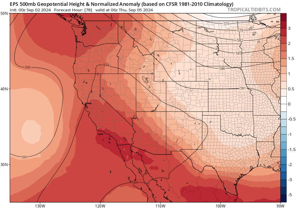
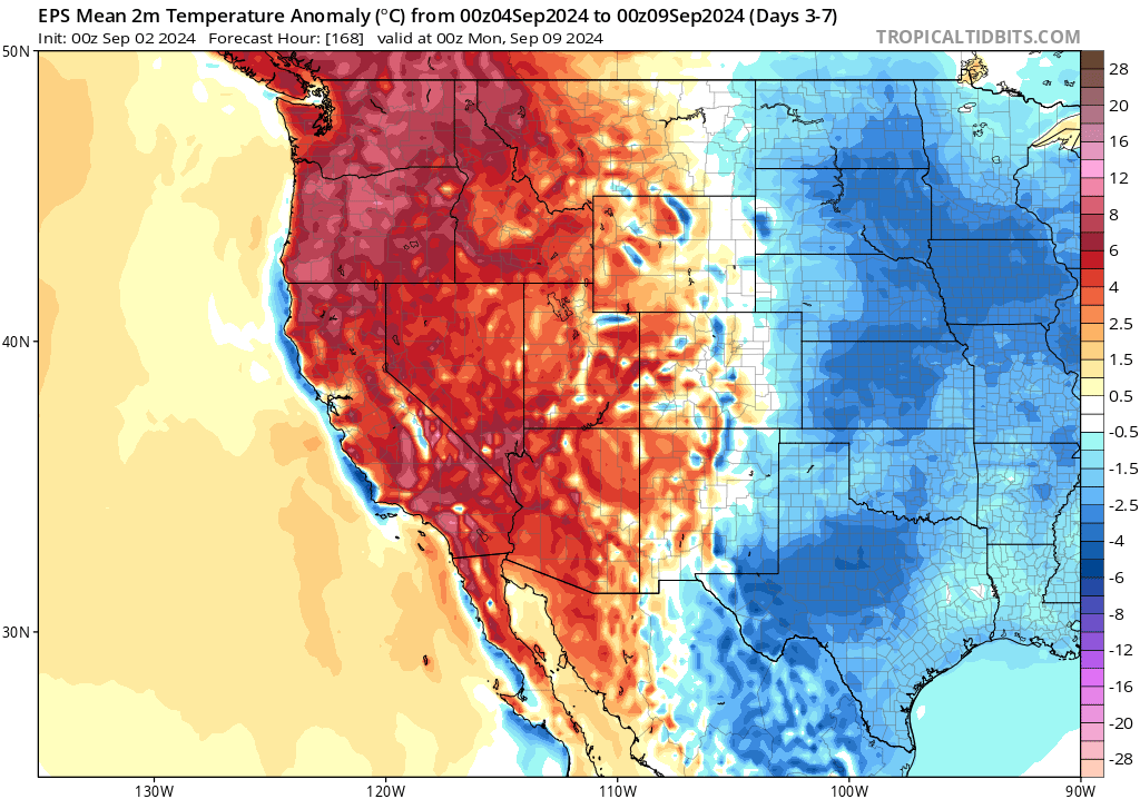
After the cool and locally damp weather in mid-August, quite a few folks were asking: “Is summer over? Is fire season done? Is the rainy season just around the corner?” And as much as I’d like to be able to tell folks that’s the case: it isn’t. This week, the largest heatwave in over a month in many areas will intensify along the entire West Coast of the U.S. and extending northward into British Columbia as a broad/strong anomalous 500mb ridge builds overhead. Temperatures will be at least 5-10 F above average virtually everywhere (even along the immediate coast) and as much as 15-20 degrees above average inland. While I don’t expect any record-shattering heat with this event, unlike back in July, there may be some daily records set (especially with very warm overnight temperatures) and perhaps daytime high temperatures across the interior Pacific Northwest (some spots up there might also break records for cumulative 100/105+ degree days with this event, given what happened earlier this summer). Various heat-related watch/warnings will likely be issued by the National Weather Service this week, and some are already in effect.
This heat event will actually be the most notable of the year so far in coastal SoCal, where temperatures will make it into the upper 90s within just a few miles of the beaches and could locally end up as hot as 110-115F in portions of the San Fernando Valley. Weak sundowner winds will be possible along portions of the Central Coast, which could locally boost heat and fire risk there, but a strong event is not anticipated at this time.
A mix of various local setups will broadly increase wildfire risk across most of West in early Sep
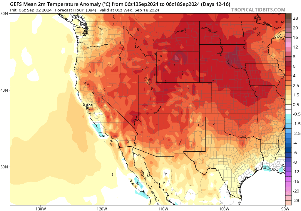
Today (Labor Day), elevated fire weather risk is present across far eastern and interior Northern CA as well as the Great Basin/eastern OR region (including Reno/Tahoe) as a combination of dry/windy conditions, plus isolated dry lightning, increases both the likelihood of new ignitions and potential behavior on fires. Although winds will die down in the coming days, temperatures will rise and humidity will drop–further drying out the landscape at a time when many regions are already nearing peak seasonal dryness. This will be true across a broad region from Southern California northward into central Washington/Oregon and eastward across the Great Basin and Rockies. In fact, it’s probably simpler to list the areas that I think will not see substantially increased wildfire activity in the coming days: the North Coast of CA (too damp and cool this summer!), far western OR/WA (not hot enough during this event and too damp as of late) and perhaps portions of the Four Corners vicinity (where Monsoon 2024 has been very active). Numerous large and active fires are already burning in Idaho, Montana, and western Wyoming, and this activity will likely expand and intensify considerably over the next 1-2 weeks as widespread heat and generally below average precipitation persists.
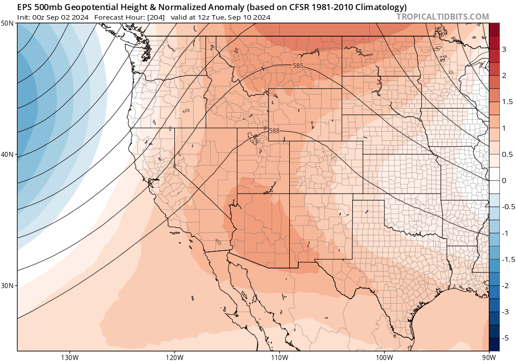
There are a couple of additional wrinkles. A handful of weaker troughs and possibly associated low pressure systems will pass through the upper portion of the ridge over the next 2 weeks. These will bring periods of cooler weather (especially along the coast) as well as occasionally breezy to windy conditions. Because this will occur in the broader context of hotter than average temperatures, and amid generally dry fuel conditions, these periods of occasional onshore winds will likely feature windows of increased wildfire risk across a broad zone.
Also, there are some weak hints that one of two of these modest low pressure systems could generate a few showers or thunderstorms (possibly containing little precipitation) at times from NorCal northward (mainly over mountains), and that could lead to some scattered new lightning ignitions as they would occur immediately following another major heatwave and drying event. For now, I don’t foresee this as a huge risk but collectively it does appear the pieces are coming together in a way that will be favorable for a major surge in wildfire activity across a broad region, with localized episodes of more extreme fire weather possible due to a combination of heat, stronger winds, and lightning. It’s unlikely that most locations will see all three of these, but I think there’s a pretty good chance of a robust “second season” from a wildfire perspective this year (following the initial July surge, there may well be another in Sep into Oct in some regions).
Heat should fade by mid-Sep, but high odds of continued warmer-than-average temps beyond
Right now, it appears likely (by assessing model ensemble trends) that the main anomalous ridge axis will persist but shift substantially inland, bringing a greater risk of highly anomalous heat to the interior West/Rockies/Central U.S. but cooler temperatures along the West Coast by mid September. Still, even with this shift, the battle between offshore troughing and inland ridging will likely yield on balance continued above average temperatures across most of California for the foreseeable future (especially inland). This remains consistent with seasonal predictions, which have consistently indicated a high chance of warmer-than-average temperatures across the West (including California) for most of the autumn. This week’s major heatwave likely will not be the last of the season for coastal California, though for the moment there’s no clear indication that another one will occur in the next two weeks. Given that the hottest temperatures in a typical calendar year usually occur in Sep or Oct across coastal California, however, that should not be too surprising!
Join me live on Wednesday, Sep 4 (2pm PT) on YouTube
My live weather and climate “virtual office hour” this week will focus on the developing Western U.S. heatwave, including implications for the rest of wildfire season 2024 (we aren’t done yet!). For regular visitors to the my still relatively new YouTube channel (~1.5 years old), welcome back! And for those of you who have made it this far in the blog post: I’d encourage you to check it out (if you can’t make it live, these sessions are always recorded, archived, and available shortly after each livestream ends).
Discover more from Weather West
Subscribe to get the latest posts sent to your email.