Extraordinary SoCal heat and wildfire surge in first half of September
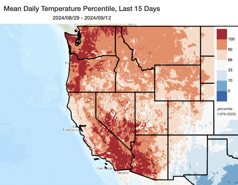
Well, the early September heatwave sure turned out to be a remarkable one–particularly across Southern California (where a number of locations came close to or even tied all-time record highs) and the Pacific Northwest (where a number of locations recorded the hottest temperatures on record for so late in the season). In SoCal, this was not a particularly dry heat–in fact, some locations logged dew points into the 70s F–representing a pretty miserable and unusual (especially for autumn) humid heatwave in which apparent (heat index) temperatures were near or even above actual temperatures.
And the heat was not the only major weather event to occur in SoCal over the past two weeks. A rather remarkable late-season monsoonal surge of moisture and instability allowed for an impressive outbreak of mountain and desert thunderstorms–some of which even extended into the Inland Empire, producing localized but substantial flash flooding in a few cases. But even more noteworthy during this period were the fast-spreading wildfires that broke out in the mountains of Southern California. The most significant of these, the Line, Bridge, and Airport Fires–each went on to cause mass evacuations and burn a varying number of structures (the official stats are still being compiled as the firefight continues, although the structure loss appears to be in the three figures cumulatively). Particularly notable was the startlingly rapid one-day advance of the Bridge Fire, which burned from near Mt. Baldy to past Wrightwood (and into the high desert) in a single “burning period.” This amounted to a 11-12+ mile linear advance, encompassing around 45,000 acres in extremely rough topography and including rapid upslope and downslope runs, in a 12-18 hour period.
Despite the reportedly substantial structure losses, it could have been a lot worse: In fact, I personally believe Wrightwood, Running Springs, and perhaps even the western Big Bear regions all avoided much worse outcomes that were plausible had conditions evolved just slightly differently. Wrightwood was an especially close call, as the Bridge Fire made an unexpectedly rapid and intense 10 mile run directly to the town’s doorstep–leaving little time for evacuations or resource pre-positioning. Had upslope winds been slightly stronger or lasted slightly longer, these fires could well have yielded multiple simultaneous wildland-urban interface disasters in the SoCal mountains given the ambient conditions and resource constraints; similarly, had a significant offshore wind developed after these fires were already established, the fires could have switched direction and wreaked similar havoc downslope in the more heavily populated urban fringe. Fortunately, that did not happen–and through a combination of hard work by a massive contingent of fire crews and a bit of good luck, the remarkable September 2024 SoCal wildfire outbreak did not become a major catastrophe (though considerable losses still did occur).
The record-breaking heatwave immediately preceding this notable wildfire outbreak in SoCal was undoubtedly a major contributor to these fires’ intensity and rapid spread. Additionally, across the highest elevations and easternmost portions of the fire zones, exceptional heat earlier this summer also exerted a cumulative vegetation drying effect (although this latter statement was less true to the west and at lower elevations, especially with respect to the Airport Fire, since conditions in coastal LA county were not exceptionally hot this season until early Sep). This, combined with the previously discussed legacy of heavy grass/brush growth in SoCal following two consecutive very wet winters (which increased fuel loading), resulted in a “1-2” punch: The antecedent climate and weather conditions helped to generate “more fuel for the fire” in grass and brush-dominated settings as well as “kiln-dried” that extra fuel with subsequent record-breaking heat. Some readers may recall this is a similar dynamic that unfolded back in July with the NorCal wildfire outbreak, allowing for exceptionally rapid rates of fire spread in grass and brush-dominated ecosystems.
Additionally, the atmospheric instability associated with the monsoonal surge allowed each of these fires to develop rather dramatic pyroconvective columns, including full-fledged pyrocumulonimbus (aka pyroCb/fire thunderstorm) clouds that at times reached above 40,000 feet in height. These pyroCbs generated numerous lightning strikes, very erratic winds, and even localized downpours–all of which complicated firefighting efforts while offering quite a dramatic view from across much of SoCal.
Fortunately, over the past 48-72 hours or so, much cooler temperatures, lighter winds, and even a bit of marine layer moisture have greatly moderate fire activity. And there’s more of that good stuff to come…
(Much) cooler, damper pattern this weekend into mid-week across CA w/associated wildfire reprieve
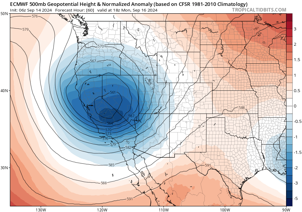
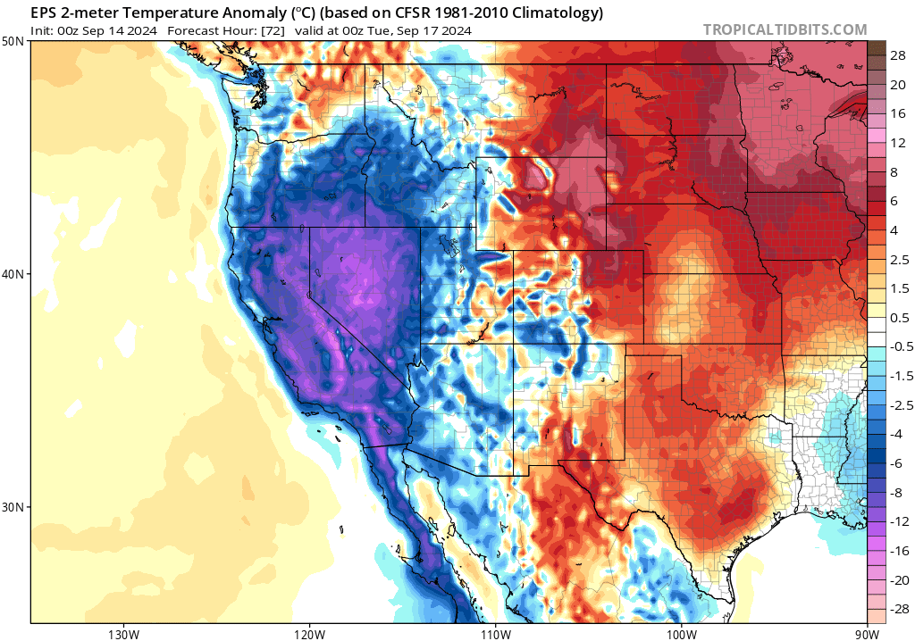
Many folks will be glad to hear that the weather pattern this week in California will be pretty ideal if you are tired of the heat and wildfires as of late, especially in SoCal! An unseasonably deep and cold low pressure system will dive down into Northern California Sunday into Monday before moving eastward, and will be followed by a similar (but weaker) secondary low on Tue-Wed. This pattern shift will bring dramatically cooler temperatures to the entire state, but the contrast will be especially extreme in SoCal where some places experienced temperatures near all-time records not much more than a week ago and may even see a few “record low maximum” temperatures in a few spots!
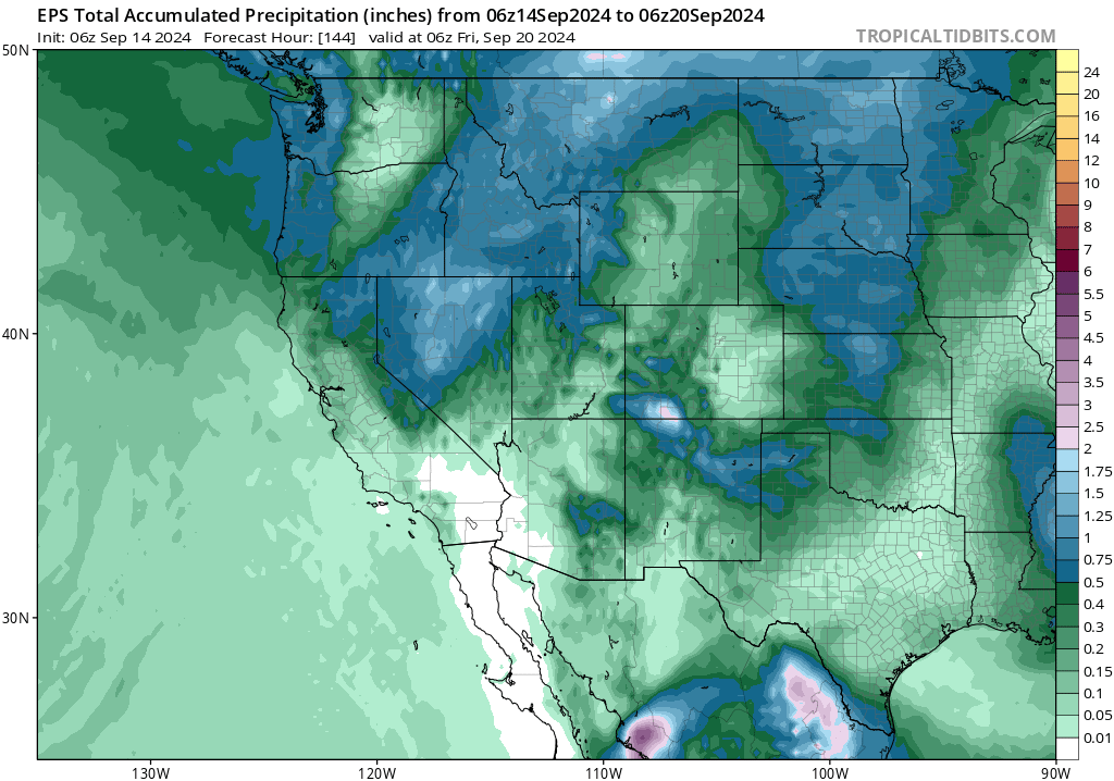
How about rain? Well, there will likely be a decent amount in northeastern California with this pattern, and the chance for some lighter/briefer precipitation elsewhere. Up to a half inch or so–a good soaking–may occur up in far interior NE CA and in the Shasta region; several tenths, still notable for the time of year, could even extend down into the northern Sacramento Valley and the Tahoe region. Elsewhere, some scattered showers will be possible as far south as the SF/Monterey Bay areas and I-80 corridor (anywhere from a trace to a tenth of an inch) and some “enhanced marine layer drizzle” from very deep coastal stratocumulus clouds could occur in coastal SoCal–including some of the mountain fire zones, where again a trace to locally as much as a tenth of an inch may dampen the ground (with perhaps a bit more than that on the coastal slopes under 6,000 ft elev). It’ll also be windy as the lows move through, with local gusts to 30-40+mph, but fire risk will mainly be low due to high humidity and even some precipitation locally. And the high Sierra–above 8,000 feet or so–could even see another early season dusting to couple of inches of snow accumulation. That’s decidedly less unusual in mid-Sep than when it occurred back in Aug, but it’s still nice to see after a long, hot summer. There could even be a few isolated thunderstorms, mainly in interior NorCal, though at this time this does not appear to be a super convectively active event.
If this does not sound like a whole lot of rain in most places…you’d be correct. This will be far from a fire-season ending rain event for California, and many places will see no rain at all. But overall, this pattern will offer a solid 7-10 day fire weather reprieve and allow fire crews to make major progress on existing fires in SoCal (which remain active, though already far less so than in recent days).
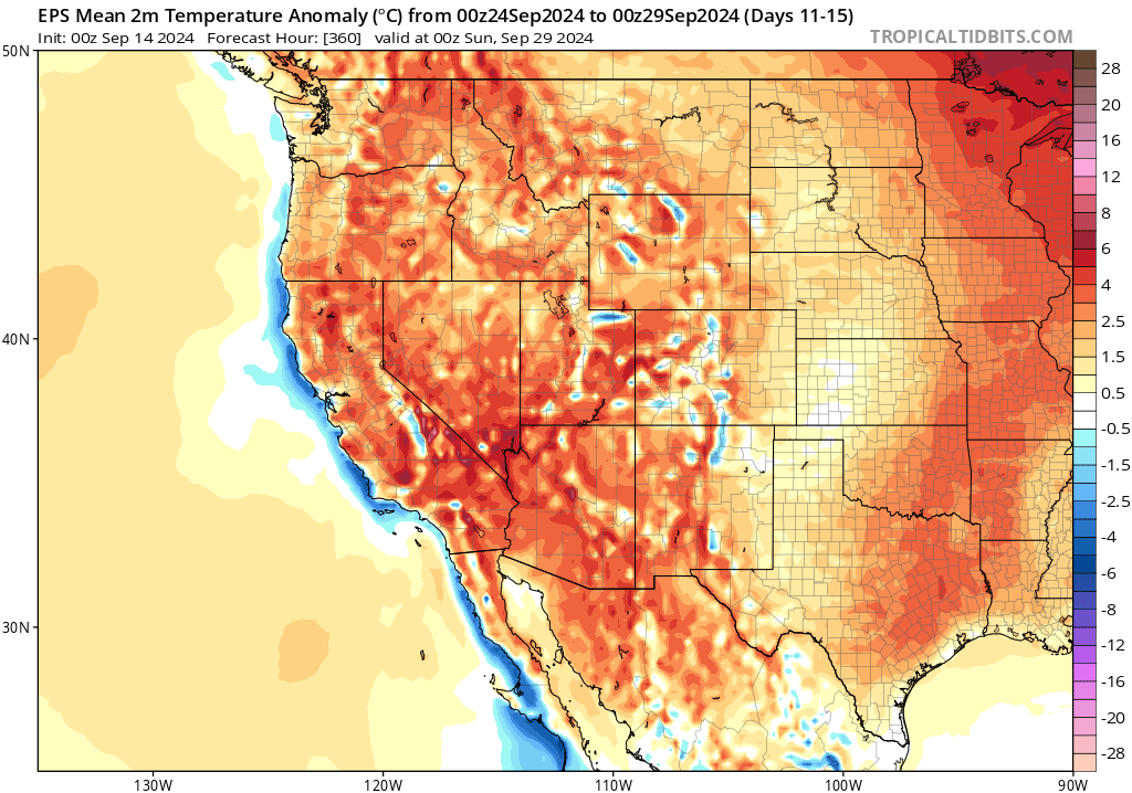
Warming again by the last week in September
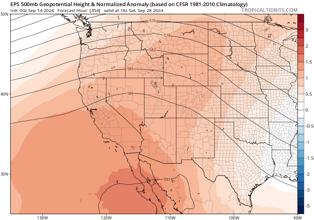
Alas, it is still mid-September–and, absent a highly anomalous widespread heavier rain event (of which there is currently no indication)–we should still expect to see periods of warm and dry weather for at least the next month or so. And one such episode does appear to be on the horizon as soon after cold low/trough moves out of California in about a week or so. From then until the end of the month, a stronger ridge appears likely to once again build back in over California and the adjacent eastern Pacific–bringing a return to warmer than average and dry conditions. With this warmer and drier shift, I would not be surprised to see another uptick in wildfire activity (particularly central and SoCal, though less so in the far north where rain will fall this week). Offshore wind season has yet to begin in earnest, and if/when Santa Ana or Diablo winds occur this fall fire risk will rise accordingly (until it rains substantially). So enjoy the next 7-10 days of low wildfire risk across most of the state; there may yet be a couple of pulses of (especially wind-driven) activity to come later this autumn as the legacy of a very hot (and record hot, in some places) summer and/or early September, combined with the lagged effect of anomalously abundant grass/brush growth from 2 consecutive wet winters in central and SoCal coastal areas, are still apparent on the landscape.
Remainder of autumn continues to look warmer and drier than average across most of CA
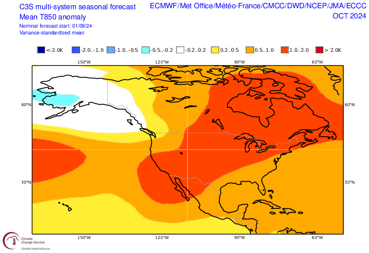
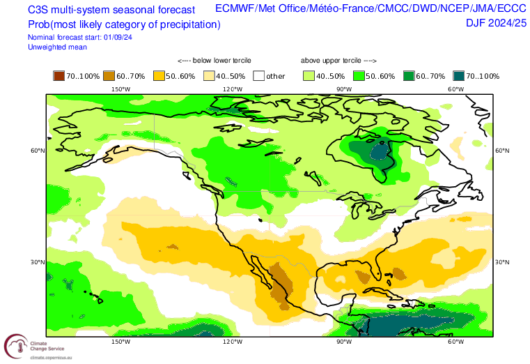
In the most recent (September) seasonal model ensemble update, La Nina is once again looking a bit stronger for this coming winter after fading in the August update. (This behavior is something we’ve seen before, both with ENSO and large-scale pattern predictions during storm season.) At this point, La Niña conditions of some magnitude appear likely this coming winter, and although most models aren’t suggesting it’ll be more than a moderate event at this point (at least using traditional metrics), there are also some indications that the atmospheric response may be a bit more robust than we might usually expect from an event of this magnitude.
The two primary pieces of evidence for this claim? Well, first of all, in a non-stationary climate in which the global oceans are constantly accumulating heat, fixed “sea surface temperature anomaly in a box” ENSO metrics tend to systematically underestimate the effective “strength” (in terms of the spatial ocean temperature anomalies) of La Niña events and overestimate El Niño events due to the background warming. When more flexible ENSO metrics capable of accounting for this long-term warming of the the oceans are used, the projected La Nina event this winter trends closer to a moderate-strong event vs a weak-moderate one. The other evidence? At this point, there is a pretty strong signal in the multi-model ensemble average pointing to a drier-than-average winter across central and southern CA (as well as the broader Southwest)–something that would usually not pop out so prominently for a weaker La Niña event (but would be more consistent with a stronger event). For now, I still think it’s a bit of a wait-and-see situation since there remains quite a bit of uncertainty.
Join me live at 5pm PT on Mon, Sep 16 for my next Weather and Climate Virtual Office Hour!
Topic this week will be the cooler and wetter pattern shift across CA and the broader West, the associated wildfire reprieve, and my evolving thoughts for the rest of autumn (and perhaps also winter) to come. See you then!
Discover more from Weather West
Subscribe to get the latest posts sent to your email.