Following record July heat, August has been cooler (and that will continue for another week or so)

Although the tea leaves were already pretty clear from the preliminary data available when I wrote the last blog post, it’s now official: July 2024 was the hottest July (and, in many places, single month) on record for most of California away from the immediate coast. But, over the past 10 days or more, it has been noticeably less hot nearly everywhere than it was last month–a reprieve welcome by most. The first two weeks in August were still considerably warmer than average across most of California, but not record-breakingly so. And despite some inland heat that has lingered a bit longer than expected so far this week, even cooler temperatures are quite likely by this weekend into early next week as unusually strong autumn trough and associated low pressure system move across the Pacific Northwest.
Wildfire activity, which was dramatically elevated for much of July nearly statewide, has largely calmed down in relative terms in terms of the number of substantial new starts and in the intensity of fire behavior (though both remain elevated relative to seasonal norms in many places). The Park Fire in northeastern California, which has burned around 430,000 acres (the fourth largest in modern CA history) across a huge swath stretching nearly from Chico to Lassen Park, is today looking much better than it was a week ago–there is little visible smoke or hotspots apparent from satellite imagery, and absent an unexpected blow-up I expect the presently burned area will be within 10k acres or so of its final footprint. Others have discussed the mixed ecological effects of this fire in different settings and ecosystems (likely net beneficial in the grasslands on its western side and also likely pretty devastating in many mature forest stands that it made high intensity upslope runs through under extreme burning conditions), and the fire also damaged or destroyed nearly 700 structures while forcing weeks-long displacement of thousands of people. Other fires over the past month or so have also destroyed structures and forced substantial evacuations, but the Park Fire remains, to date, by far the largest and most destructive of the past three fire seasons.
Unseasonably deep PacNW low = widespread PacNW thunderstorm outbreak, with slight spillover in far NorCal

This weekend, a very conspicuous pattern change will occur along the West Coast thanks to the arrival of an unseasonably deep low pressure system centered just off of the southwestern Oregon coast. This late summer system, which will be quite unusual though not unheard of for mid to late August, will bring widespread soaking rainfall to much of the Pacific Northwest from the Cascades westward. Notably, this system will be associated with a rather unstable airmass so fairly widespread thunderstorms will also be likely in this region. Most or all of these storms will be wet (vs dry), so wildfire ignition risk will be on the lower side in Washington and Oregon though it will definitely not be zero; while widespread, precipitation is unlikely to be very heavy in most spots and there is a real possibility of “holdover” fires popping up next week after a few days of drier weather given how hot and dry it has been across the interior PacNW in recent weeks. So while I believe that this event will be net beneficial from a fire weather perspective in the PacNW due to widespread precipitation, the caveat is that there may be some new/remote ignitions that will spring to life down the line as things dry out again.
California will also see some impacts from this pattern shift, although they will be less widespread and dramatic the farther south one goes. Some substantial showers could fall along the far North Coast, and some isolated or scattered precip could potentially fall as far south as Mendocino County and as far east as Shasta County. Although less likely that farther north, some isolated thunderstorms could also occur in this region. While not immediately likely, I can recall several similar late summer/autumn systems like this in the past that manage to develop a line of high-based showers/thunderstorms on the far southern flank of their weak cold front that manages to produce some dry-ish lightning strikes and brief showers 50-100+ miles farther to the south than models are indicating–so that’s something to keep an eye on.
Elsewhere, the most noticeable effect in NorCal will be much cooler and windier conditions. This multi-day period of elevated southwesterly flow and locally stronger/gusty winds, especially at higher elevations, could actually cause a period of increased wildfire risk across portions of the Coast Ranges and Sierra Nevada this weekend despite cooler temperatures given the very dry vegetation that exists now up to around 5-6k feet following July’s record heat and spring 2024’s abundant grass/brush growth (although dryness remains somewhat mitigated at the highest elevations due to antecedent wet winters). It’s possible there could be a few red flag warnings this weekend in areas subject to cooler but windy conditions that do not receive any precipitation. The expanding Boise Fire in Humboldt County, burning in a fairly remote region, may see a mix of conditions including some wind followed by some rainfall (though probably not enough to extinguish the fire).
In SoCal, there will not be much of a discernible pattern change and conditions may even remain slightly warmer than average across inland areas during this period.
Hints of hotter end to August and start to September
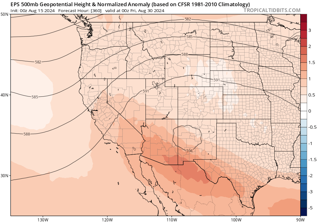
Looking ahead to late August, there are consistent signals from the major global model ensembles that a strong ridge will once again rebuild across the interior Southwest. In fact, this ridge is quite likely to reach record strength for August across New Mexico–portending likely record-breaking late season heat there. Across California, this building SW ridge will have two effects. First, temperatures will gradually and then more rapidly rise from slightly below to near average and then to potentially well above average levels once again by the end of the month, especially across central and southern portions of the state. This late season Four Corners ridge will also be favorable for one or two late-season monsoonal surges into SoCal during this period, though the specific timing of these events won’t be clear until a couple days prior. Overall, though, the pattern going from late Aug into early Sep is one that would once again favor anomalous heat and increased wildfire activity across much of the West.
Seasonal outlook update: high odds of warmer & tilt toward drier than average autumn; wildfire risk looms
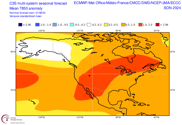
As previously noted, this autumn looks like an especially warm one across the interior Western U.S. and likely extending increasingly toward the coast in CA (especially central and southern CA) Sep through Oct or Nov. The latest batch of seasonal model outlooks came out a few days ago, and they continue to paint a similar picture: very high odds of a broadly much warmer than average airmass over the Southwest for autumn, and also a modest tilt in the odds toward a drier-than-average autumn (especially Sep and Oct and especially in central and southern CA as well as the central/southern Rockies). Unless there is another “saved by the bell” moment (like last year’s tropical soaking from Hilary or a very early season atmospheric river up north), this likely portends a very active autumn fire season across much of CA and the interior West–potentially leading to a second peak in fire activity that could eclipse July’s wildfire surge despite conditions that will likely not be quite as hot.
Why is this the case? Well, vegetation in most of California and across much of the interior West (outside of the core monsoon zone in the deep SW) reaches peak seasonal dryness in September or October following the canonically long and dry summer (which, in many spots, has been record hot to date). That, combined with a spurt of grass and brush growth thanks to milder and wetter growing conditions the past 2 winters and springs, means there’s both more fuel for the (potential) fires at lower elevations as well as the potential for vegetation to be even drier than usual (perhaps approaching record dryness levels again) in precisely those areas most susceptible to autumn heatwaves and offshore (Santa Ana/Diablo) wind events (and therefore wind-driven fires). That could be a volatile combination this year, and updated seasonal outlooks from federal fire agencies mirror this concern.
We don’t have any ability to predict offshore wind events at seasonal scale, nor (beneficial) atypical rain events or (harmful) autumn lightning outbreaks. But we can, to a reasonable degree of certainly, predict how anomalously warm the autumn may be–and we also know with 100% certainty what came before (i.e., a wet winter/spring and record hot July). The stage is therefore set for a potentially fiery autumn–perhaps much more so than “usual”–but we could get lucky (or unlucky) with early rains, offshore wind events, or fall lightning events. That is to say: while the predictable aspects of autumn fire risk are ringing alarm bells, that isn’t always the whole story (based, essentially, on luck in one direction or another). But I do think it’s quite likely that this autumn will feature much more active fire conditions not only in California (where this is not uncommon) but also across portions of the interior West (where it is decidedly less common)–and almost certainly more active conditions than the past couple of (relatively quiet) years. So…enjoy the relative reprieve over the next 10 days or so, and stay tuned!

My 2025 extreme weather and climate Page-A-Day calendar is now available!

My 2025 extreme weather and climate page-a-day calendar is now available! Within, you’ll find 312 bite-sized entries describing atmospheric processes, extreme statistics, weather/climate trivia, and more. This is an update of the 2024 version, including a considerably amount of new and reworked content. Check it out! Use code “CAL25” for a 20% discount from the publisher using the link above.
Live YouTube weather and climate office hour: Friday, August 16, at 10am PT
Discover more from Weather West
Subscribe to get the latest posts sent to your email.