Hottest July (and single month) on record across most of California. Again.
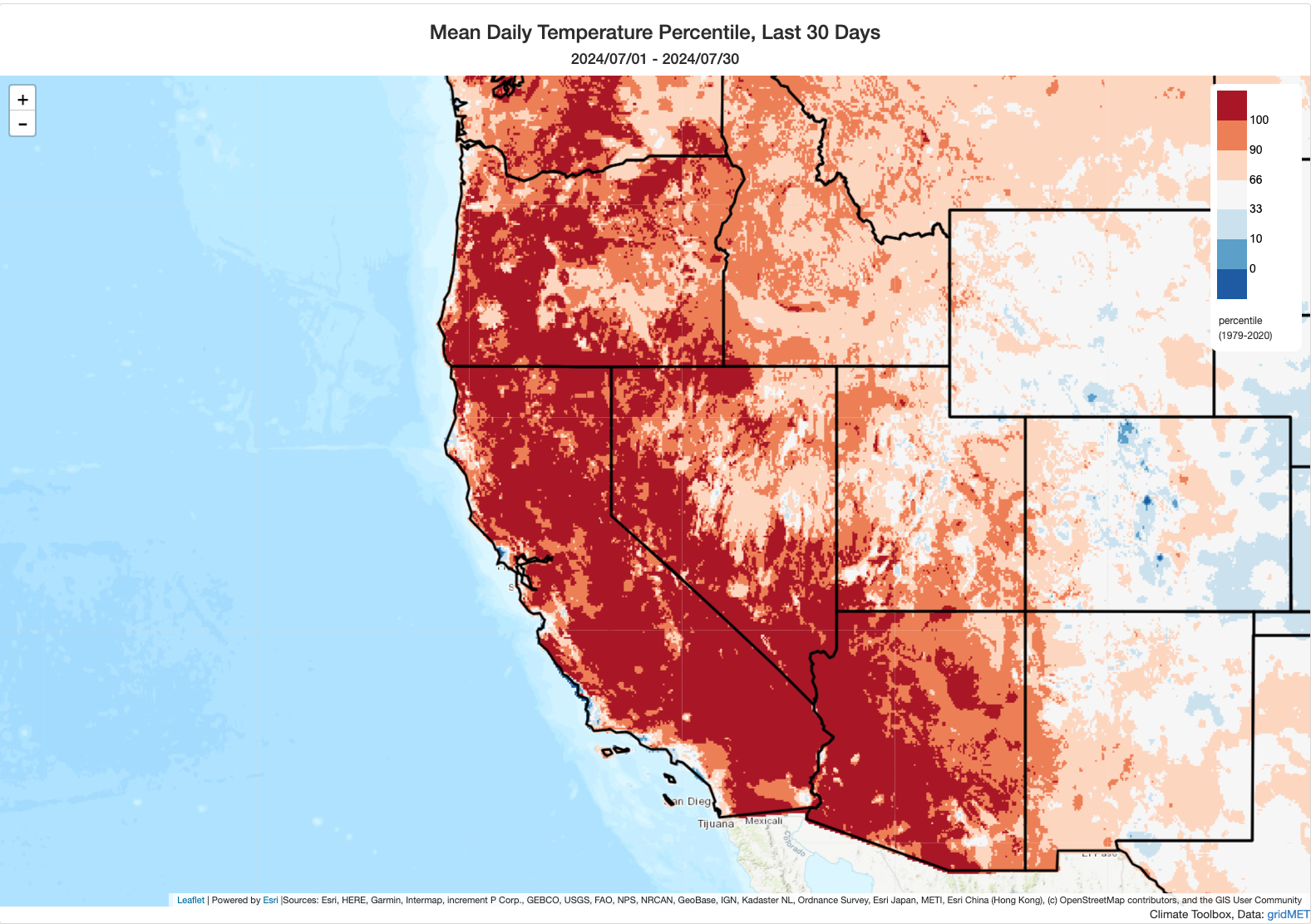
Well, we did it again: for the Nth time in the past decade or so, California experienced its hottest July on record. (This is certainly the case across inland regions, and likely at a statewide level, though not the case in most coastal locations. I don’t know the exact statistics yet since NOAA won’t release the official numbers until next week.) July’s heat was remarkable not only for its sheer intensity (a number of sites saw their single hottest daytime and nighttime temperatures on record during this period) but also for its duration–temperatures remained extremely elevated for weeks on end and did not substantially cool off at night, especially in the foothill thermal belts. This exceptional heat led to a period of similarly remarkable atmospheric “evaporative demand,” which rapidly desiccated vegetation at lower elevations (especially in central and northern California, where winter 2023-4 was not as exceptionally wet as in SoCal) and facilitated a spate of fast-spreading wildfires. Fortunately, the heat moderated considerably in the last few days of the month, though this was not enough to prevent monthly records from being broken.
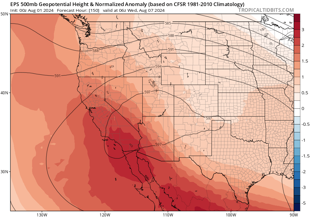
Another double-barreled heatwave inland, but nowhere near as extreme as last one
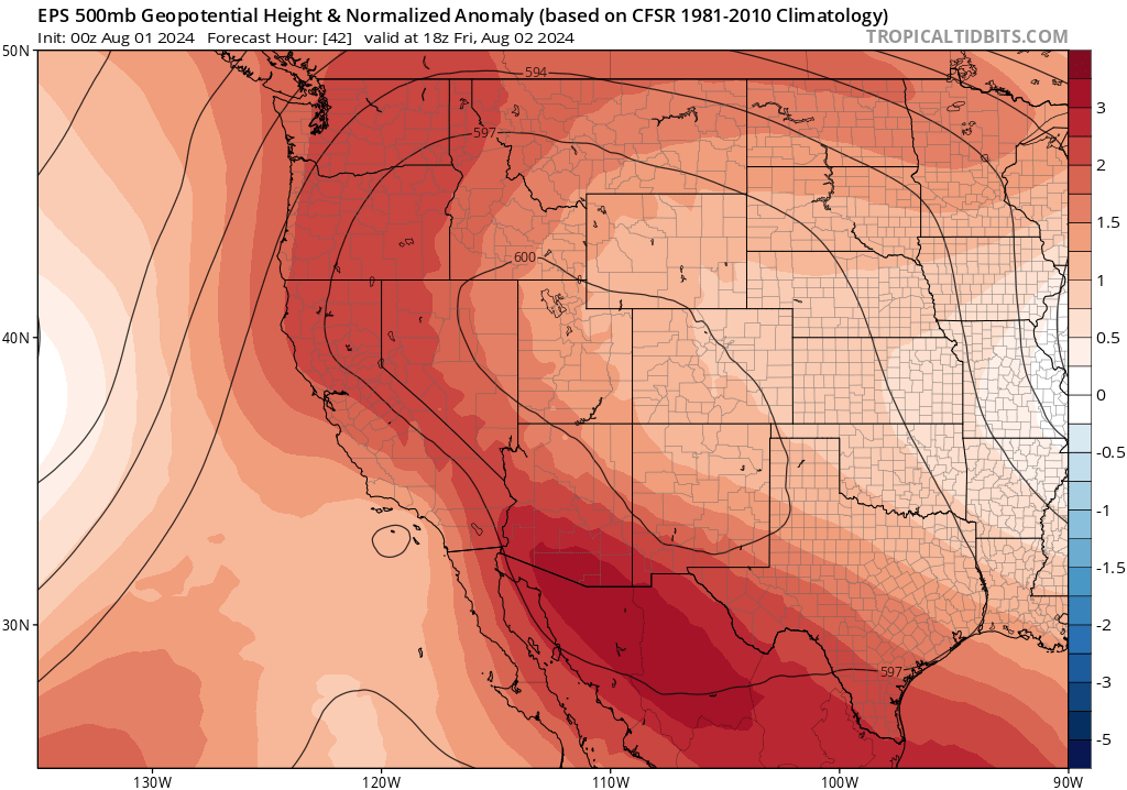
News folks inland probably don’t want to hear: another heatwave is now underway, and it will likely be both prolonged (lasting 7-10 days in total) and double-peaked (one on Friday this week, and another around next Wednesday). However, there is some good news in this: right now, there’s no indication this heatwave will be anywhere near as intense or prolonged as the July event. So while it will be quite hot across inland areas much of the time in the coming days, it will likely feel “not that bad” in comparison to the events of the past 30-40 days. Still, quite a few inland cities will add to their already highly anomalous cumulative number of 100/105+ degree days in 2024–perhaps setting yet more records in the process or setting the stage for that to happen later this season when additional heatwaves inevitably occur.
Monsoonal surge Thu-Sat brings mtn/desert t-storms, and slight risk of (dry?) lightning elsewhere
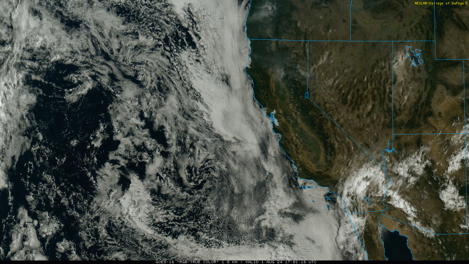
Some other considerable weather of note: a robust surge of monsoonal moisture (moving in a westerly/northwesterly direction) is presently unfolding over SoCal. In fact, a distinct easterly wave is clearly apparent on satellite imagery moving almost due westward–bringing a very moist airmass (especially aloft) from the Desert SW/Sonora into California.
The combination of considerable elevated moisture with a moderately unstable airmass aloft, plus the mechanical forcing from the easterly wave itself, will likely set off a round of fairly widespread thunderstorms over the SoCal interior later today (mountains and deserts especially). There will probably be at least some isolated thunderstorm activity that makes it west of the mountains and out onto the coastal plain, so there will be a slight chance of thunderstorms today in Santa Barbara/LA/San Diego proper and perhaps out even over the coastal waters. This activity will probably not be super widespread west of the mountains, but it could occur just about anywhere.
Although there is quite a bit of moisture present in the ambient monsoonal airmass being advected into the region, most of that moisture is well above the surface. So while most SoCal t-storms over the next 48 hours will feature at least some precipitation (locally heavy in narrow swaths), they may also have a propensity to generate some lightning strikes outside of narrow rain cores and therefore lead to localized dry lightning (a risk highlighted in Red Flag Warnings from the NWS for the Central Coast mountains as well as the Southern Sierra).
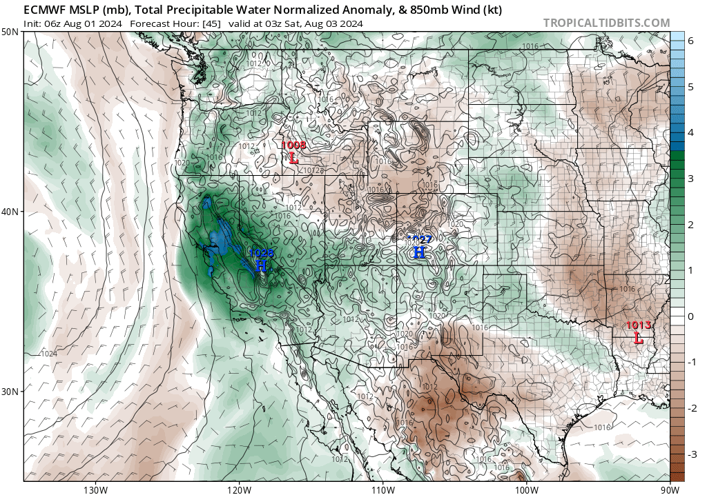
Fri into Sat, this moisture and instability will progress northward across central and northern California. There will be a pretty good chance of thunderstorms over the Sierra Nevada during this period, including western slopes down into the foothills. This may comprise a mix of wet and dry storms, so there will be some risk of new wildfire ignitions (and certainly some risk of enhanced fire activity on existing fires due to plume-dominated/pyroconvective enhancement, as well as strong/gusty/erratic outflow winds from nearby cells). This pattern will also bring considerable mid-level moisture and modest amounts of elevated instability to coastal and valley regions in NorCal. While I don’t currently expect a widespread lightning (or dry lightning) event in these regions, there is probably at least a 5-10% of some dryish thunderstorms over the Central Valley (locally higher east side and north end) as well as the SF Bay Area/Coast Ranges. Not looking like a huge threat right now, but I do want to mention it as a nonzero possibility Fri into Sat. These kinds of patterns are always difficult to discern in advance, since the atmospheric characteristics that differentiate substantial dry lightning outbreaks from simple “pretty sunset” altocumulus displays are not always obvious more than 6-12 hours in advance.
That said, there will likely be at least a few new wildfire ignitions over the next 72 hours due to lightning in California, and these could occur in SoCal, NorCal, or both.
First half of August: Still warmer than average, but less remarkably so
The other good-ish news is that while the first half of August appears likely to be yet another warmer than average period, especially inland, it does NOT appear likely that it will be exceptionally so (so not as hot as July). Coastal areas may actually remain pretty close to average temperatures during this period, as well, with fairly effective “natural air conditioning” via the marine layer.
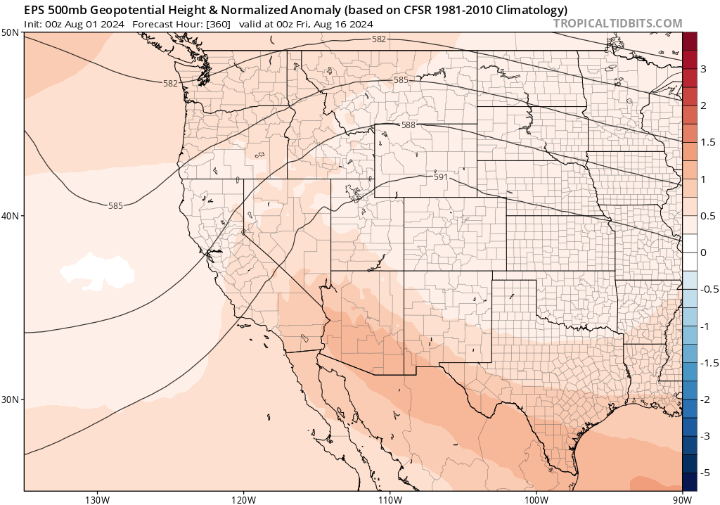
I will note that there are still pretty strong signs that Sep and Oct could once again be very warm months–perhaps even exceptionally so–and given the typical seasonal cycle of coastal upwelling and the marine layer, these likely late season heatwave would be much more likely to reach the coast. I still also have considerable concerns regarding another major spike in wildfire activity during the autumn in California, given a strong tilt toward warmer than average conditions and a modest tilt toward a later than usual start to the rainy season (during canonical dry “offshore wind” season). But I’ll have more to say about that in a couple of weeks.
Wildfire situation update: Elevated risk in coming days, but nothing extreme on horizon (for now)
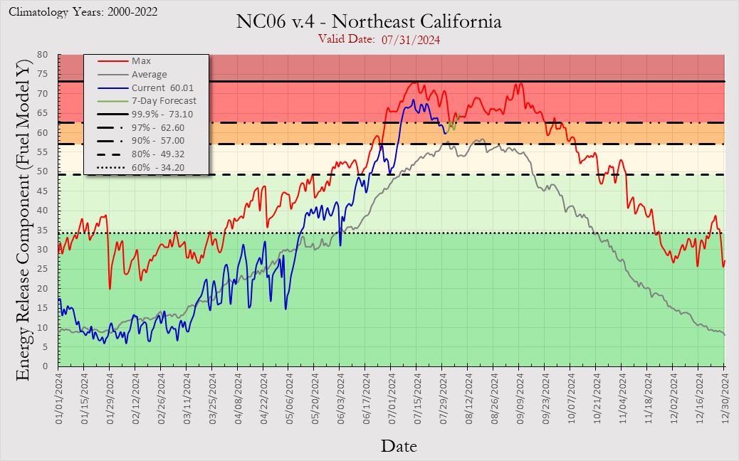
As noted earlier, the extreme/record-breaking July heat and evaporative demand event facilitated a major spike in California wildfire activity, especially at lower to middle elevations. That extreme heat is now over, though more modest heatwaves will result in secondary activity spikes over the next few weeks. Bulk vegetation flammability metrics spiked extremely rapidly and to exceptional (at or near record-breaking for the time of year) levels back in July in many parts of NorCal and Central CA amid the extreme heat, but have since fallen back to merely “above average” levels in most spots (and, along the coast, right back to average for early Aug). In SoCal (and also at the highest elevations in NorCal), the flammability spike was less dramatic–likely muted to a considerable degree by the exceptionally wet winter of 2023-2024 down south. Hence, there is actually a considerable amount of variability in the “degrees of anomalousness” of vegetation moisture levels at present across California. If we do end up seeing an exceptionally hot/dry autumn, as appears plausible, there will probably be more convergence toward greater-than-average flammability across a wider range of landscapes and ecosystems heading into offshore wind season. But for the first half of August, at least, I’d except wildfire activity to be dominated by interactions with convective activity (especially Thu-Sat this week and during any subsequent monsoonal waves), with some new lightning ignitions likely and more active plume-dominated fire behavior on existing fires during such episodes. There will also likely be increases in activity/spread rates after each (modest) heat wave peak as southwesterly prevailing winds occur, especially for fires occurring in NorCal. Outside of these periods of thunderstorm activity–which are always wildcards and can sometimes cause fires to “misbehave” on short order, I would expect overall activity to remain elevated over the next few weeks but to a lesser degree than the frenetic July pace. In Sep-Oct, though, I would expect to see another considerable uptick–so the season is far from over, and may well end up running longer than would be the case under typical historical conditions.
Another way to support the site: Weather West advertising opportunity
As you have likely noticed, I have (for nearly 15 years!) run what I hope are minimally invasive ads on Weather West to support the (growing) costs of running the site and also to augment other weather/climate communication activities. Occasionally, I run hand-selected ads from specific entities that are interested in reaching the fairly unique audience that visits this website on a regular basis. If you might be interested in this kind of opportunity, please reach out to me via the contact form above and we can have a conversation!
Live YouTube “weather and climate office hour” Fri, Aug 2, 1pm Pacific Time
Join me for a live discussion on the monsoonal moisture surge, July heat records, and ongoing wildfire activity!
Discover more from Weather West
Subscribe to get the latest posts sent to your email.