Summary of recent atmospheric river precipitation event (Feb. 7-9)
A significant atmospheric river event affected much of Northern California this past weekend, bringing widespread precipitation and a fairly narrow band of impressively heavy rainfall extending from the coastal mountains north of San Francisco to the northeastern foothills of the Sierra Nevada. In this region of enhanced precipitation, storm-totals exceeded 5 inches and in a few orographically-favored locations even exceeded 10 inches. Sacramento finally received some significant rainfall from this event, and rainfall in the San Francisco Bay Area varied tremendously from north to south (from over 10 inches at Cazadero and Mt. Tamalpais to less than 0.25 inches in parts of the Santa Clara Valley).
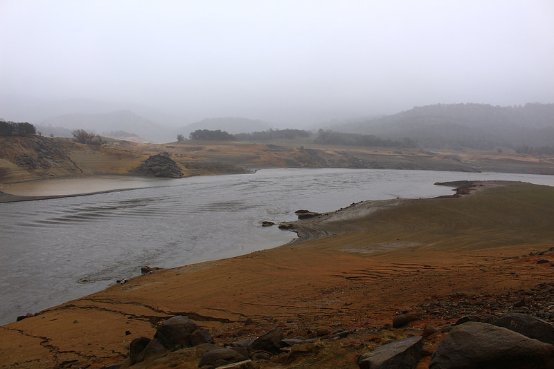
This dramatic local and regional variation in precipitation is not uncommon during wintertime precipitation events that are primarily orographically-driven, as was the case with the extremely moist but relatively weak “Pineapple Express” system this past weekend. There were some local flooding impacts due to the locally excessive rainfall–a situation which may well have been exacerbated by the low infiltration capacity of the record-dry soils throughout California–but overall this was a beneficial rain event. Snow levels in the Sierra were quite high, but most places saw at least some accumulations on the back end of the storm as snow levels dropped (and those relatively few regions above 8000 feet received heavy snowfall for the duration of the event).
Did the recent (locally) heavy rainfall bust the California drought?
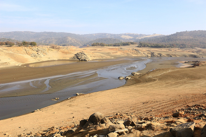
While the recent atmospheric river did bring much-needed precipitation to parts of Northern California, California is unquestionably still in the midst of an extraordinary drought. The most recent update of the Drought Monitor depicts a slight (and likely
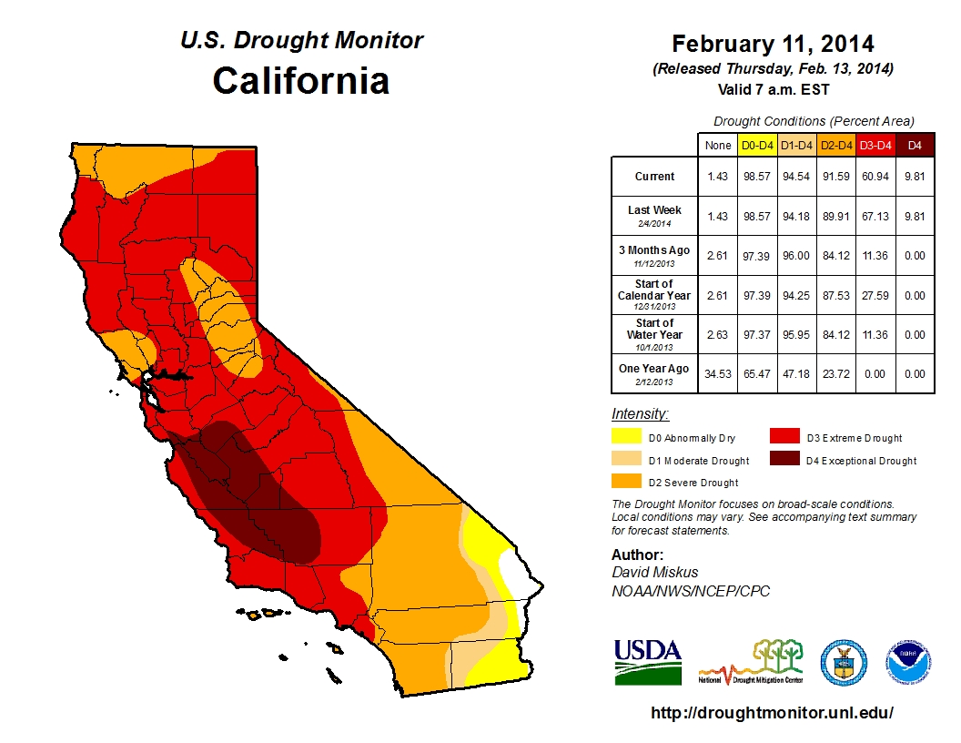
temporary) reduction in the severity of the drought over parts of NorCal that received heavy precipitation from the atmospheric river, but the core of the drought region remains in “exceptional” territory–the most severe categorization. Rainfall intensity was sufficiently high to generate substantial runoff in some regions that were already experiencing critical short-term water shortages–such as the eastern suburbs of Sacramento (i.e. Folsom Reservoir) and communities in Mendocino County (including the Willits area). Inflows to many of NorCal’s major reservoirs spiked over the weekend, and for the first time in many months net storage actually increased statewide.
But what impact did this storm really have in the scheme of things? A quick glance at California’s current precipitation deficits answers that question pretty definitively. The figures below depict the percent-of-average precipitation for the last 30 days and for the “water year” to date (since October 1st). The main point here is that the locally heavy precipitation event this past weekend was barely enough to bring the regions that received the heaviest precipitation up to average–just for the month! Essentially all of California remains below 50% of average for the season to date, and most of the state is still below 25% of average.
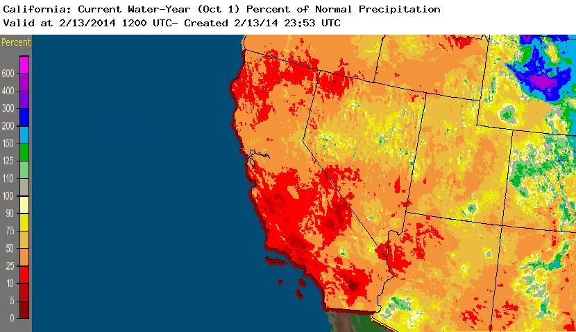
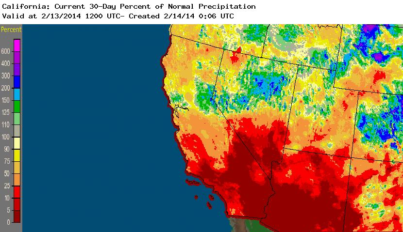
Percent-of-average rainfall; 30 days (left), Water Year 2013-2014 to date (right). (NWS)
Near-term outlook: some NorCal rain, mostly light
The plume of enhanced atmospheric water vapor that brought heavy precipitation to NorCal last weekend has shifted northward, but is actually still bringing significant precipitation to Pacific Northwest and as far south as the North Coast region in California. This rain will likely persist for a few more days and probably spread southward later this weekend, though any precipitation that makes it down as far south as the Sacramento/San Francisco regions is likely to be quite light. This pattern may repeat itself once more later during the coming week as a strong storm system develops over the Eastern Pacific but weakens dramatically as it approaches California. Precipitation this coming week will be much less substantial than what was observed last weekend, and areas south of the Bay Area are (once again) unlikely to see any precipitation whatsoever. Despite recent hopes that the overall pattern would transition towards a more active state for a more extended period of time, recent model solutions are increasingly suggesting that ridging will once again start to build off of the West Coast during week 2, bringing a return to dry and generally stable weather conditions for most of California during the second half of February.
What happened to the Ridiculously Resilient Ridge?
Many readers may be wondering about the fate of the RRR, which has been a frustratingly persistent feature of our weather over the past 14 months. It’s certainly true that the ridge in the northeastern Pacific has weakened considerably over the past two weeks, and the portion over the Gulf of Alaska has essentially disappeared. At the same time, the semi-permanent East Pacific subtropical high has remained unusually strong for this time of year, which is the primary reason that Southern California has remained high and dry even as far northern parts of the state have recently received substantial precipitation.
The RRR, as defined back in December, is not a categorically monolithic feature–it has waxed and waned considerably during its period of relevance, shifting around between the central North Pacific east of the Aleutian Islands in the Gulf of Alaska in the west and the Pacific Coast of North America in the east. In general, though, a region of high-amplitude ridging and associated highly-anomalous wind patterns have been present somewhere within this box more often than not since last January. Despite slight breaks in the ridge’s dominance and longitudinal shifts in its primary axis, this atmospheric pattern has ultimately resulted in the extraordinary persistence of record-dry conditions throughout California. For this reason, I’m reluctant to announce the “death” of the RRR until we’ve experienced at least a month of more typical atmospheric conditions.
Unfortunately, it now appears that the RRR may try to make a comeback during the second half of February. Recent model solutions are bringing considerably drier and more stable conditions back to California after the coming week’s light rainfall, and the ensembles are starting to hint at an all-too-familiar pattern of geopotential height anomalies over the northeastern Pacific. At the moment, the projected magnitude of these anomalies doesn’t look quite as extreme as the record-shattering ones observed in January, but this pattern could lead to much-below-average rainfall in California once again as we head toward March 1st. It’s hard to say at this point how long this new dry pattern might last once it becomes established, but at the moment it does not appear that any sustained period of widespread, significant period of precipitation is on the horizon.
© 2014 WEATHER WEST
Discover more from Weather West
Subscribe to get the latest posts sent to your email.