Recent Weather Summary
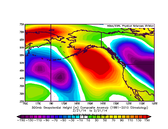
Unusually dry and warm conditions have returned to California over the past week. In the wake of the atmospheric river event two weeks ago, high pressure built back over the far eastern Pacific and has acted to deflect most storm activity to the north of California, which is a pattern very reminiscent of the one that has been seemingly locked in place for many months over the same general geographic region. What differentiates the present atmospheric ridging from the much-maligned “Ridiculously Resilient Ridge,” however, its is lack of persistence. The fairly high-amplitude ridge currently in place will be undercut by an impending surge in strong westerly winds over the coming week, which is something that hasn’t happened to any meaningful extent in over a year.
Drought Update
Despite the locally heavy rainfall brought about by the atmospheric river precipitation event two weeks ago, drought conditions over most of California have actually continued to intensify. The most recent Drought Monitor update suggests that the area of “exceptional” drought conditions expanded substantially throughout in Central California over the past two weeks. Inflows into Northern California reservoirs–which spiked notably in the wake of the precipitation event two weeks ago–have returned to well-below-normal levels.
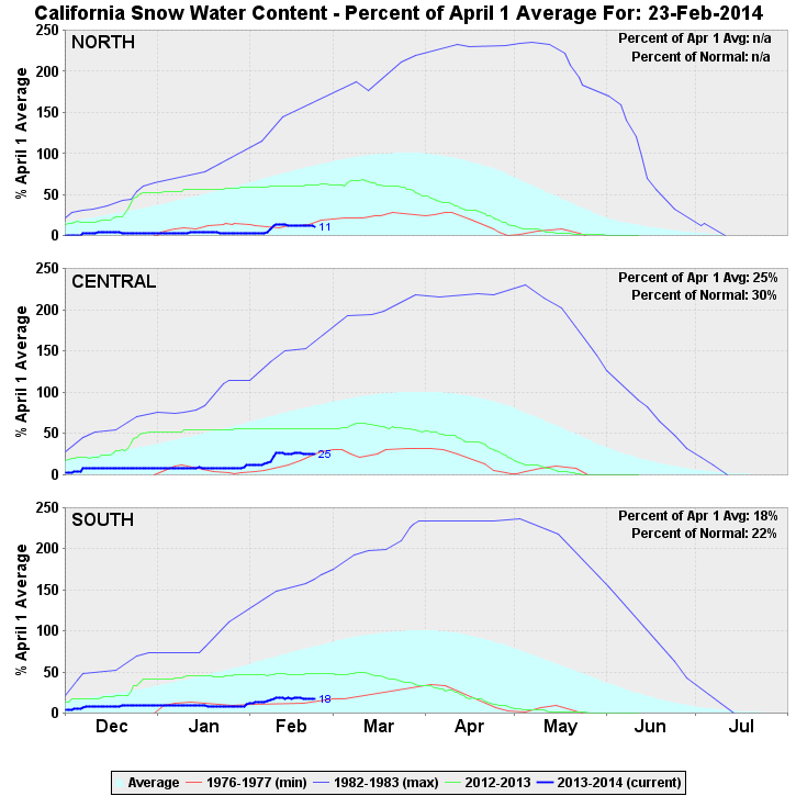
Remarkably, most of the state–which is experiencing one of the driest water years on record following the driest calendar year on record–is actually below average for the month of February to date, despite the observed rainfall. The Sierra snowpack, which did not benefit as much from the warm subtropical precipitation event earlier this month as it would have from a colder system, is once again tracking at all-time record-low levels. By nearly any available metric, truly extreme drought conditions continue throughout California.
Strong storm for all of California on Friday/Saturday
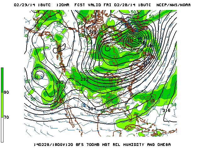
It’s not all doom-and-gloom, however. A drastic, high-impact pattern change is on the way that is likely to affect the entire state of California this week, bringing an excellent chance of soaking rainfall all the way from San Diego to the Oregon border. In fact, it currently appears that two storm systems will move ashore this week, though the first one will bring only light to moderate precipitation to the northern part of the state on Wednesday. All eyes are currently focused on the second storm, scheduled arrive on Friday. For the first time since December 2012, a deep, well-developed trough will arrive just west of the California coast and direct a deepening low pressure center over the Golden State. This trough and associated surface low pressure system will coincide with the appearance of a temporarily enhanced East Pacific jet stream, which together will set the stage for a substantial statewide precipitation event.
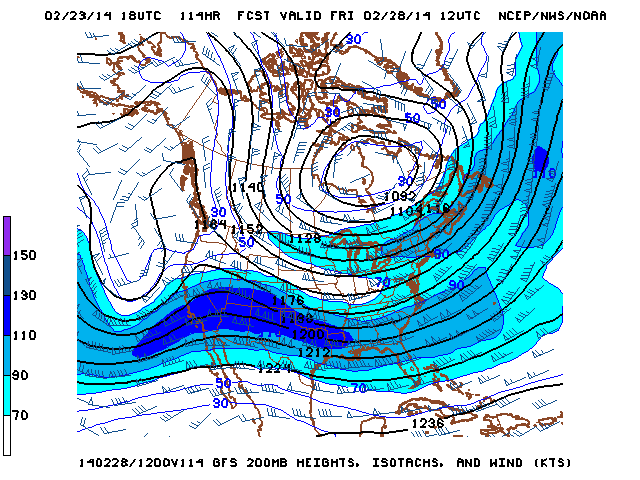
California will be located underneath a region of strong upper-level divergence in the favorable left exit region of a strong jet streak rounding the base of this deep trough, which will allow the surface low to deepen as it approaches the coast on Friday. Given the presence of a sub-1000mb surface low near the NorCal coast, a strong Pacific jet overhead, strong upper-level divergence, and the presence of more than adequate lower tropospheric moisture, most of the necessary ingredients will be in place for a pretty impressive storm event across much of California, especially by the middling standards of the past year or so.
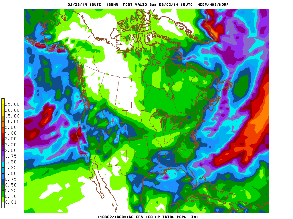
Heavy precipitation can be expected for at least brief period in many locations, especially near the time of cold frontal passage. Strong upward vertical motion and modest near-surface instability suggest the potential for convective activity as well, with possible high rainfall rates and thunderstorms (especially across Southern California). Strong and gusty winds may also be an issue, especially given the proximity of the surface low to the California coast and the potential for convection to mix strong winds aloft down towards the surface. I actually expect precipitation amounts to be surprisingly uniform from north to south, with generally 1-3 inches both along the coast and inland all the way from Eureka to Los Angeles, with areas to the south potentially seeing somewhat less than that but orographically favored regions (especially the Transverse Ranges in SoCal) locally seeing 3-5 inches. While these totals are well under the highly localized extreme 10+ inch values observed in NorCal during the recent atmospheric river event, I expect that this storm will bring more water to California overall given the widespread nature of the precipitation. Brief flooding of vulnerable urban areas and small streams will be possible given the potential for high rain rates. This will be a fairly cold storm system, and beneficial snowfall on the order of 2+ feet can be expected at pass level in the Sierra Nevada.
Regarding the strong wind potential: right now it appears that strong and gusty winds may occur along and near the coast, especially in NorCal. These winds will most likely not be extremely strong, but there is some uncertainty given the proximity of a deepening surface low. It’s not out of the question that some of the windier locations could see gusts in the 50+ mph range, which could result in localized downed trees and power lines given the absence of strong southerly winds in these regions associated with our nearly nonexistent cold frontal passages over the past 14 months.
It’s also worth noting the potential for some fairly strong convective activity along and following the cold front on Friday/Saturday. The above-mentioned dynamics and the eventual progression of the surface low over NorCal on Saturday could lead to scattered thunderstorm activity, some of which could contain some very heavy rainfall and gusty winds. There is a slight possibility of more widespread strong thunderstorm activity if certain elements come together optimally late this week.
In short: widespread, beneficial rain and snow will fall throughout California this week. The upcoming storm system will be strong, but not exceptionally so: it’s of a magnitude we’d expect to see at least a couple of times in a typical winter. But since this winter has been anything but typical, it’ll seem pretty impressive by recent standards and thus has the potential to be a high-impact event.
Unfortunately, this dramatic pattern change does not appear to be a harbinger of sustained precipitation to come. After this coming weekend, there is a fair bit of uncertainty regarding the exact pattern evolution, but there are signs that fairly strong ridging will (yet again) build back in over the eastern Pacific, keeping California mostly dry following this week’s wet weather. Some recent model runs have hinted at the return of RRR-esque high-amplitude ridging during week 2, though right now it’s not clear that this will come to fruition. For now, it’s probably best to focus of the substantial precipitation expected to fall later this week.
Recent developments in the tropical Pacific: El Nino on the way?
I’ve hinted a couple of times since late last year that some of the long-lead forecast models were suggesting that warm conditions in the tropical eastern Pacific Ocean might develop in the coming months. Seasonal forecasting is a tricky business, and despite recent advances the accuracy of predictions beyond 3 months remains rather low (which is not to be confused, however, with the skill of probabilistic projections made by global climate models over much longer timescales).
Despite this “predictability barrier,” there are occasionally instances when increased confidence in long-lead (3-6+ month) predictions may be justified based upon actual, real-time observations of the coupled ocean-atmospheric system. It currently appears that we may have just such a situation developing in the Pacific at the present time.
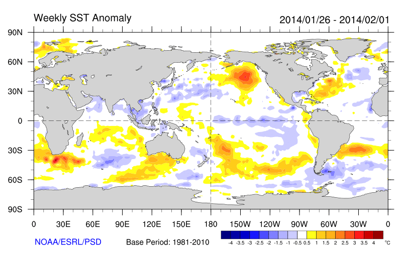
Current sea surface temperature anomalies are not very impressive at first glance. In fact, there are presently negative SST anomalies in the eastern tropical Pacific–which is typically indicative of a La Nina state–and positive SST anomalies in the west. The situation becomes much more interesting, though, when we look (quite literally!) below the surface. There has been a substantial pool of subsurface warm anomalies in the West Pacific for quite some time, but this warm water has remained rather stationary well to the west of the Dateline. Warm subsurface water in the West Pacific is one of several necessary precursors to an El Nino event, but this means very little if there is no eastward progression of the anomaly signal.
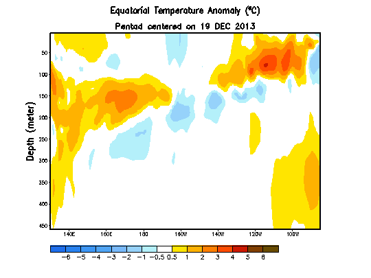
Recently, however, a series of oceanic “Kelvin waves” have been observed propagating across the Pacific. The first (and weakest) of these began all the way back in September 2013, and the most recent (and strongest) first became apparent in January 2014 and is at present moving eastward across the Pacific basin. Kelvin waves–which are described in greater detail here–are low-frequency, eastward-propaging waves in the equatorial ocean that act to flatten the west-to-east temperature variation that typically exists in the Pacific Ocean. As consecutive Kelvin waves (associated with westerly wind bursts and anomalous upwelling/downwelling conditions) act to weaken the Pacific “thermocline,” warm water in the West Pacific “sloshes” toward the east and East Pacific SST anomalies increase–and an El Nino is born. The present Kelvin wave may be the strongest observed in the Pacific since the powerful 1997-1998 El Nino event, so the present situation current bears watching (especially considering that the best numerical models suggest the likely emergence of El Nino conditions by mid-summer).
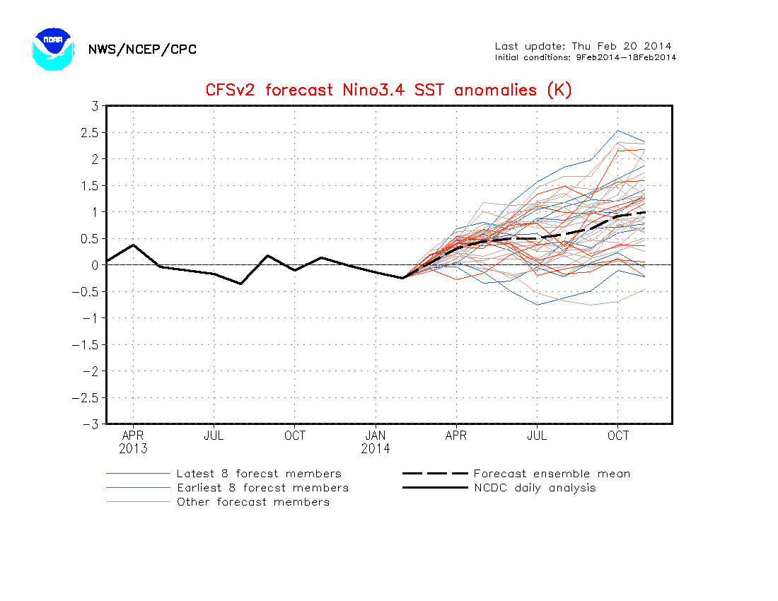
An important caveat is that these westerly wind bursts need to keeping happening over the next few months if the extremely warm subsurface waters currently located in the Central Pacific are to eventually surface in the traditional ENSO region. There’s no guarantee that this will happen, although recent forecasts suggest the emergence of another westerly wind burst over the next week or so. For now, I’m comfortable stating that El Nino conditions are becoming increasingly likely beginning this summer and continuing into next fall/winter. Also, recent subsurface heat anomalies suggest that the potential exists for a strong El Nino event if everything comes together in the coming months.
It’s important to remember that teleconnections between weak to moderate El Ninos and wintertime precipitation in California are not actually all that strong, but top-tier El Nino events almost always bring above-normal precipitation. This has important implications for the interpretation of these forecasts in the context of the California drought: while the development of a strong El Nino event would very likely be good news from a water supply perspective, it’s far too early to make a prediction regarding next winter’s precipitation prospects (even if El Nino conditions are looking increasingly likely). I’ll be following developments in the Pacific closely in the coming months. Stay tuned!
© 2014 WEATHER WEST
Discover more from Weather West
Subscribe to get the latest posts sent to your email.