Special Update: heavy precipitation makes at least a brief return to N. California
Given the ongoing extreme drought conditions and the potential for a high-impact rain event in Northern California over the next 72 hours, I’ve provided the following (brief) update in the interest of keeping up with the rapidly changing weather pattern.
Atmospheric River expected to bring heavy precipitation to Northern California
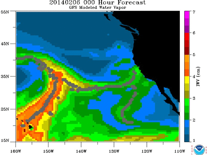
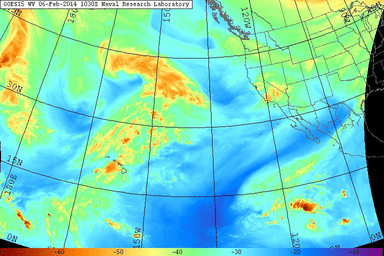
“Heavy” and “rain” are not words that have been used in the same sentence for a long time here in California, but it does appear that–for the first time in 14 months–some truly substantial precipitation is headed for parts of NorCal. I discussed in my last post the seemingly modest potential for an Eastern Pacific atmospheric river to impact California over the upcoming weekend, and in the meantime the numerical forecast models have trended considerably stronger with this event. Current satellite imagery depicts the early stages of what promises to be a significant precipitation event over the weekend.
Atmospheric rivers: a quick overview
“Atmospheric rivers” are long and narrow bands of highly-concentrated water vapor that occur in association with extratropical cylones (i.e. winter storms) throughout the Earth’s middle latitudes, especially over and near ocean basins. These features are often associated with extreme precipitation and flooding, especially along the mountainous western coast of North America (including California). To put the magnitude of these events in context: atmospheric rivers are (in aggregate) responsible for over 90% of global atmospheric water transport between subtropical and mid-latitude regions, and a single strong event is capable of moving an amount of water equivalent to 15 times the flow rate of the Mississippi River!
Those familiar with California weather and climate can attest to the critical role played by atmospheric rivers in driving wintertime precipitation extremes. I’ve noted in the past that California is dependent on just a handful of significant storm events for the majority of its annual precipitation, and this handful is usually associated with atmospheric rivers. California’s great floods in the historical past were almost all associated with atmospheric rivers, including the spectacular event of 1861-1862–which filled much of the Central Valley with floodwaters and inundated the fledgling state capital in Sacramento. Interestingly, scientists recently highlighted the important role atmospheric rivers have played in breaking many of California’s historical droughts.
One subset of atmospheric rivers affecting California are colloquially referred to as “Pineapple Express” storms, so named for their propensity to draw moisture northward from the Pacific Ocean in the vicinity of the Hawaiian Islands. Not all atmospheric rivers have such a trajectory, though most have some degree of connection to the subtropical atmospheric moisture reservoir. This weekend’s storm does actually appear to have a deep subtropical moisture tap clearly extending southward to Hawaii, so the upcoming atmospheric river does indeed meet the common definition of a “Pineapple Express.”
Short-term forecast through the weekend
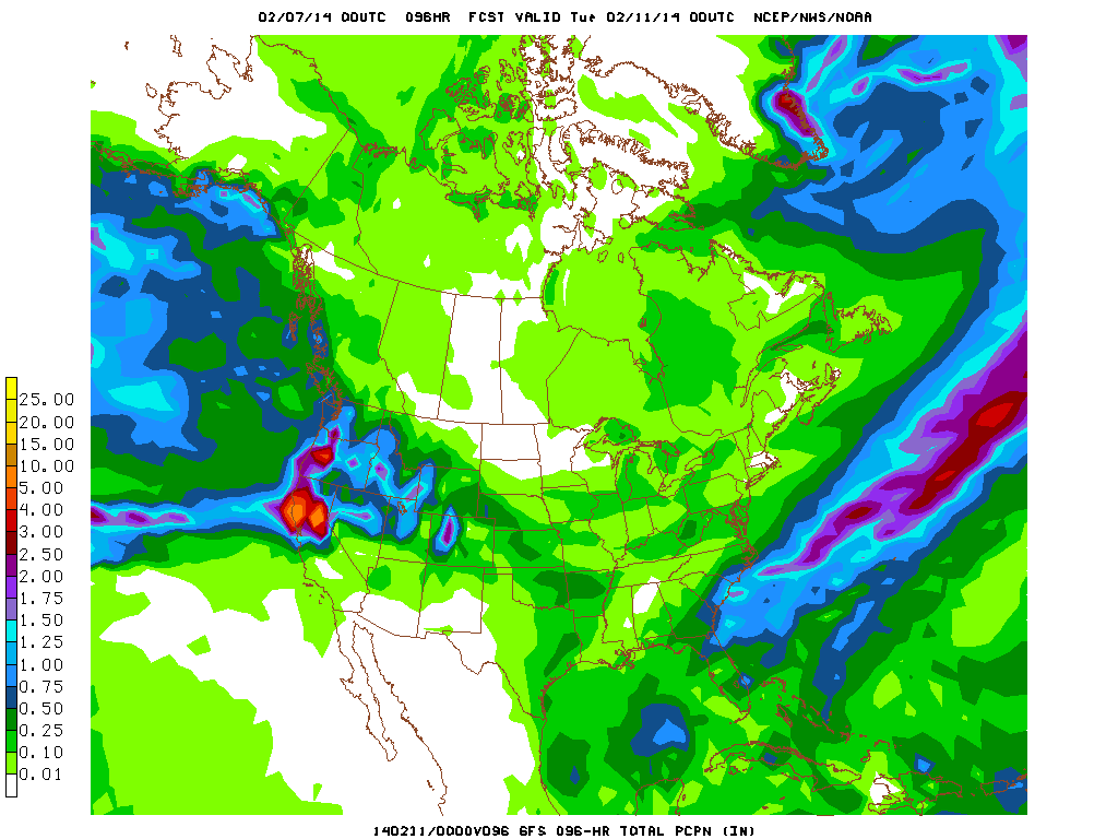
Despite the absence of a strong synoptic-scale storm system near California, the extremely moist air associated with the incoming atmospheric river will likely produce heavy rainfall in orographically favored parts of Northern California. In fact, in the coastal mountains and foothills of the Northern Sierra, rain totals by Monday could approach or even locally exceed 6-7 inches. Rain totals will be considerably less heavy (but still impressive, especially by recent standards) along the North Coast and in the Northern Sacramento Valley. The I-80 corridor between San Francisco and Sacramento will be an approximate dividing line between heavy and more moderate precipitation (though the Santa Cruz Mountains could also see rain totals approach or even exceed 4-5 inches). Rain totals at lower elevations in NorCal may be anywhere from 1-4 inches. Southern California, unfortunately, will probably receive only very light rainfall from this event. As is often the case with subtropical moisture plumes/atmospheric rivers, snow levels will be very high for most of this event–well above 8000 feet in most cases.
Rainfall of this magnitude will be capable of causing some modest hydrological issues in some regions, including the possibility for urban and small stream flooding. Main stem rivers will be very unlikely to experience flooding given the record-dry antecedent conditions, but since this will actually be the first heavy precipitation event of the season in most places the potential for 14 months of accumulated debris to clog smaller watercourses could present some problems if rain rates are high on Saturday. Some locally gusty winds may be possible at times this weekend, but in general the lack of a strong surface low will prevent strong winds from causing significant problems.
By Monday, ridging will start to build back in across the Eastern Pacific, but a secondary atmospheric river may brush the far North Coast (near the Oregon border) will some additional significant precipitation early next week. Current indications are that most of California will trend toward drier conditions once again, but the overall pattern in the Eastern Pacific will likely be more progressive that it has been in months. I’ll have more details on this after the weekend storm passes through.
Will this weekend’s heavy rainfall end the drought?
In a word: no. There will likely be beneficial increases in streamflow and runoff into reservoirs following the most intense period of precipitation this weekend, and this storm should (finally!) put an end to the Northern California fire season, at least for a little while. However, as the National Weather Service in Sacramento has helpfully illustrated, the ratio of the amount of precipitation expected to fall this weekend to the long-term precipitation deficit is roughly the same as the volume ratio of a 10-ounce coffee mug to a 5-gallon bucket. So: while this weekend’s atmospheric river may bring more than the proverbial “drop in the bucket,” we still have a very long way to go before our extraordinary drought conditions are substantially mitigated. Stay tuned.
© 2014 WEATHER WEST
Discover more from Weather West
Subscribe to get the latest posts sent to your email.