Unsettled late spring conditions in NorCal; La Niña Looms
Cold low to bring showers, thunderstorms, and Sierra snow in NorCal this weekend
A relatively cold late-season low pressure system is currently diving southward along the West Coast after bringing some spring downpours in the Pacific Northwest.
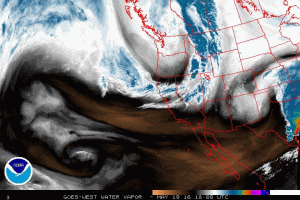
Strong surface pressure gradients associated with this incoming low have already generated strong winds across much of California, including some pretty impressive gusts at San Francisco International Airport.
This cold low will continue to sink southward over the next 48 hours, bringing with it increasingly unsettled weather conditions across the northern half of the state. Showers and thunderstorms will begin tomorrow at higher elevations and possibly spread across the Sacramento Valley by evening. As colder air aloft settles into the region and lapse rates steepen, the atmosphere will continue to destabilize through Saturday. By later Saturday afternoon, showers and thunderstorms may be pretty widespread across Northern California, likely including most of the Central Valley and much of the Bay Area. In fact, some of the same areas that have seen unusually active weather and powerful thunderstorms in recent weeks may see yet more this weekend.
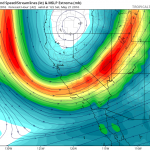
Given that the low pressure center will be directly overhead and that the late-May sun angle will allow for strong surface heating during the late afternoon hours, I would not be surprised to see reports of significant localized hail accumulations or even a few severe thunderstorms, especially in the Central Valley on Saturday.
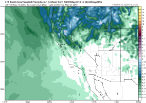
Precipitation will be showery and probably won’t be very heavy in most spots (and will likely avoid Southern California entirely). Some places in the Sierra Nevada and Coastal Ranges could see more significant rainfall totals, however. Late-season snow accumulations are also likely at and above the major passes in the Sierra Nevada, which may cause travel disruptions (especially since some seasonally snow-covered roads have recently been opened for the summer).
California’s long-term precipitation deficit lingers, and La Niña looms
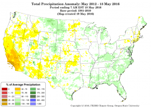
While the reservoirs in California’s wetter, more northern reaches have reached (or are nearing) capacity after a slightly wetter-than-average winter in that part of the state, multi-year water deficits remain enormous. The 2015-2016 winter did bring some drought relief to California, but nearly all long-term drought indicators continue to suggest that California remains in a significant drought. Residents of Southern California–who witnessed a much drier than average winter this year despite the occurrence of one of the strongest El Niño events on record–can certainly attest to this. In fact, nearly all of California is still “missing” at least 1 year’s worth of precipitation over the past 4 years, and in Southern California the numbers suggest closer to 2-3 years’ worth of “missing” rain and snow. These numbers, of course, don’t even begin to account for the effect of consecutive years of record-high temperatures, which have dramatically increased evaporation in our already drought-stressed region.
What does the near future hold? Well, it’s probably no surprise to anyone on this blog that California’s long dry season has nearly arrived, and that there’s little chance of meaningful widespread precipitation before next autumn at the earliest. It’s difficult to impossible to be specific about what next winter may hold precipitation-wise. That said, it does appear to be very likely that strong cooling of the equatorial Pacific associated with a developing La Niña event will be a major player. Historically, La Niña has yielded a wide range of outcomes in terms of California precipitation–including both very wet and very dry years. But historical observations and climate model simulations agree that there is a definite tilt toward dry winters during La Niña–especially in Southern California.
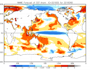
It’s also worth mentioning that the North Pacific is expected to remain very warm this coming winter despite La Niña, and that Arctic sea ice has in recent weeks plummeted to record low levels. At this point, it’s unclear exactly how these striking anomalies might affect California next winter, though this topic is currently forms the basis of considerable, ongoing discussion in the scientific community. Needless to say: another dry winter in California would not be good news, so I’ll be following these conditions closely in the coming months.
Unsettled late spring conditions in NorCal; La Niña Looms Read More »