California descends deeper into drought; “Drought Emergency” declared in NorCal
Well, unfortunately, the overall drought trajectory has not changed since the last post: it’s still getting worse. And pretty rapidly worse, at that, across much of NorCal. There, virtually no precipitation at all has fallen in places that are usually still pretty wet in April/May, and unusually persistent/recurrent north/northeast “blow dryer” winds have resulted in even more evaporation and snowmelt across the landscape.
The statewide Sierra Nevada snowpack is now down to an absolutely abysmal 8% of average for the calendar date–from 15% 5 days ago–and at this rate could be completely gone in just another week or so. Additionally, because soils underneath the snowpack have been so parched, and the air above the snowpack so dry, the majority of the snowpack we *did* have this year has either soaked into the soil (without runoff) or even sublimated directly back into the atmosphere. This means that streamflows are even lower than would otherwise have been expected in this very low precipitation year, and reservoirs will see very little further recharge for the rest of spring and summer.
A formal drought emergency (which is, as I’ve previously mentioned, is at least as much a political designation as a scientific one) was declared for Sonoma and Mendocino Counties a couple of weeks ago, and was apparently dramatically expanded across much of NorCal earlier today. Some smaller water districts are now starting to issue urban conservation mandates. Notably, the Marin Municipal Water District, which lacks broader inter-ties to statewide water systems, is currently discussing placing an emergency pipeline across the Richmond-San Rafael bridge (as last happened in 1976-1977, but not during the 2012-2016 drought) if conditions do not improve by next winter.
Warm with elevated fire weather for a few more days
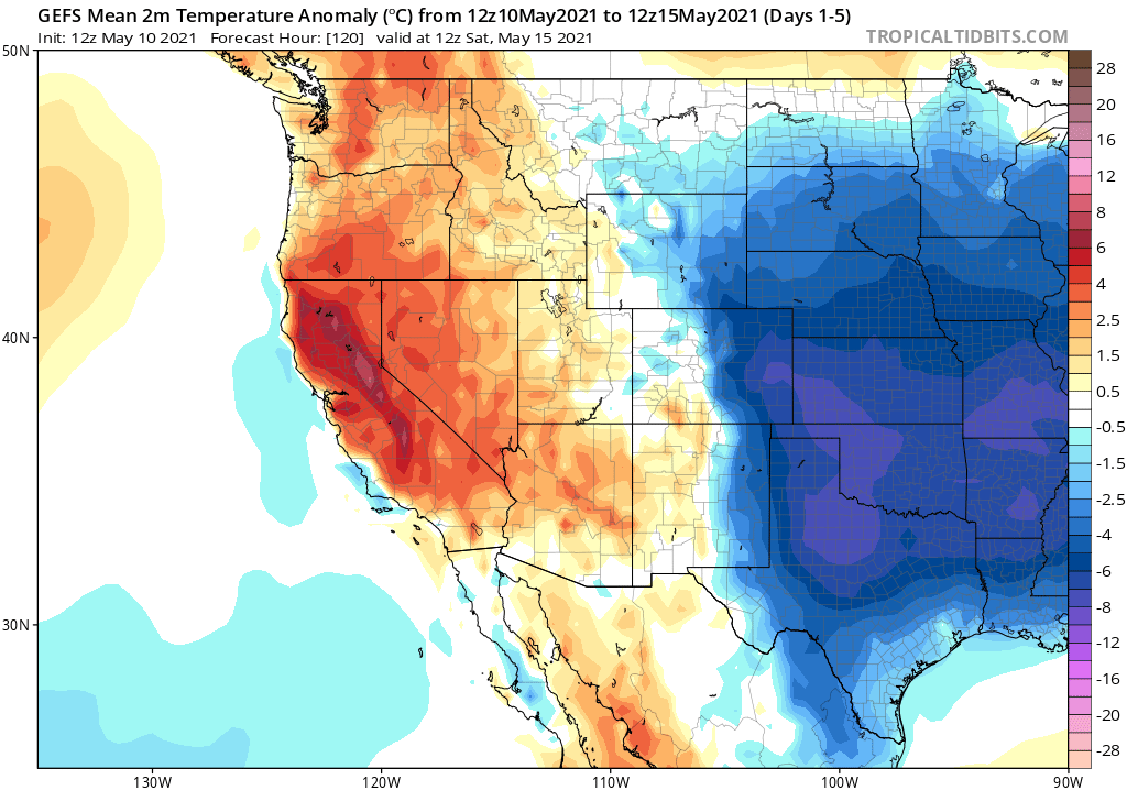
Recent days have brought much warmer than average temperatures to most of CA, and a very early spate of critical fire weather conditions in some areas across the northern portion of the state. These conditions will continue for a few more days, but slowly taper off–and cooler temperatures will likely arrive by the coming weekend (especially near the coast, where a pretty respectable marine layer will return.
Some short-term relief: Cooler weather statewide & robust coastal marine layer
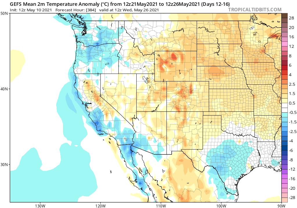
The good news I do have to report at the moment is essentially all in the short term. Once temperatures cool significantly later this week, they will likely remain relatively low for a solid 7-10 day period thereafter as some late season “troughiness” occurs near the West Coast. A couple of weak cut-off lows may even make it as far west as the Sierra Nevada or the Central Valley. Given the time of year and that they will be very moisture-starved, I would not expect much precipitation with these weak lows. But some model solutions are hinting at the possibility of isolated/scattered rain showers/thunderstorms across the CA interior (mainly Sierra Nevada, but perhaps also a few spots in the Central Valley if there is any significant wrap-around convection). This could happen on a couple of occasions over the next ~2 weeks. Most places, however, will probably not see any rain at all–the primary effect will to bring much cooler (and even locally below average) temperatures.
A secondary effect, thanks to the induced persistent northwesterly flow along the coast, will be an increase in the strength and persistence of the marine layer. This means lots of coastal fog and low cloudiness over the next couple of weeks–perhaps occasionally accompanied by accumulating coastal drizzle in both NorCal and SoCal. It won’t help with the drought, but it will very likely (if temporarily) tamp down the very early season wildfire risk in the coastal forests.
Some thoughts on the summer and autumn fire season to come
There’s no sugar coating it: it looks like Fire Season 2021’s gonna be a rough one in California (and throughout much of the West, unfortunately). A combination of factors–including short-term severe to extreme drought, long-term climate change–are in alignment for yet another year of exceptionally high risk across much of California’s potentially flammable landscapes. Vegetation moisture is already at peak summer-like dryness in many places, and is breaking records in some spots (especially in NorCal). There are essentially no mitigating factors foreseeable between now and the end of fire season sometime in the autumn–so I do expect things to ramp up from here.
The period of greatest risk will probably be from August into October when vegetation reaches maximal seasonal dryness and when offshore winds start to ramp up (unless we get really lucky with some early autumn rains–but that has become substantially less likely in recent years). But fire season is already well underway, and large fires of some magnitude will probably start occurring at higher rates within the next couple of weeks. While just about any place with potentially flammable vegetation will be at elevated risk, there are certain kinds of ecosystems that may experience an especially amplified fire season this year. California’s forests–including both normally very moist coastal forests as well as the drier forests of the Sierra Nevada–are incredibly dry already this year, and will only get drier as the season wears on. There has been quite a bit of discussion recently in the fire and ecological communities regarding the potential for elevated forest mortality statewide this year, and greatly elevated fire risk in some coastal NorCal places that have seen very little recent historical fire activity. Contrarily, I would expect to see little to no fire activity this year in the deserts and other areas with already sparse vegetation made even sparser by the drier conditions (so probably no repeat this year of the 2020 Dome Fire in the Mojave National Preserve).
It is important to keep in mind, though, that only some aspects of the potentially very severe fire season to come are predictable. There was no way to know more than a couple of days in advance that NorCal was going to see a historic dry lightning event in August 2020–a catalyst for an incredible surge in fire activity that persisted for months thereafter. The occurrence of back-to-back record-breaking heatwaves last season was also not specifically foreseeable–though we should definitely expect events like that to occur more often (broadly) in a warming climate.
Essentially, the predictable aspects of fire season are: 1) how dry are antecedent climate/vegetation conditions, and 2) what is the overall temperature outlook for the summer to come? Well, since vegetation conditions are currently setting new records for dryness and flammability, and because the seasonal outlook continues to call for a warmer than average summer/autumn across most of CA, it’s easy to see why many folks are concerned.
But with the aspects of fire season that are unpredictable on seasonal scales–including dry lightning outbreaks, successive extreme heatwaves, and autumn offshore wind events–we might get lucky. The known and predictable pre-conditions are already ringing alarm bells, but if we are fortunate with short-term fire weather conditions, and if there are relatively few fire ignitions at the wrong place/wrong time, this year might not be all that bad in retrospect. It’s possible! And I really hope we do get lucky. But leaving it up to luck is, decidedly, not a great feeling–or an effective management/mitigation policy. So this year, like last year, it will be very important for folks to be prepared for what could come in August, September, and October.
Discover more from Weather West
Subscribe to get the latest posts sent to your email.