It’s really, really dry out there
I wish I could be writing that there was a late-season pattern reversal since my last post, with widespread drought-mitigating rains. Unfortunately, the reality has been nearly the opposite of that–the precipitation spigot has remained largely closed since the last blog update, and conditions have been quite warm at times (especially across inland areas). One exception has been along the immediate coast, where *below average* (!) ocean temperatures have allowed a strong marine layer to persist.
But these cool coastal temperatures have not helped mitigate the extraordinary rate of snowpack loss in the Sierra Nevada, which has apparently reached a record fast pace at many observing sites in recent weeks. CA’s DWR reports that snow water equivalent is now down to only 28% of average on a statewide basis–and there is essentially no meaningful snowpack remaining in the southern Sierra. All of this, combined with continued extremely low precipitation in recent weeks, has led to further worsening of already severe drought conditions, particularly across portions of NorCal. In fact, a state of “Drought Emergency” was declared this week for Sonoma and Mendocino Counties, and I would expect that declaration to continue to expand over the coming months as reservoir levels and water supplies already very low in some nearby places. (Marin County, for example, recently announced water use restrictions amidst one of its driest winters in a century.) Illustrating this, the Drought Monitor now indicates that a great majority of California is now experiencing severe to extreme drought conditions, and 100% of the state is at least “abnormally dry.”
April showers this weekend, courtesy of (former) Supertyphoon Surigae
There is a bit of good news in the very short term: precipitation will still likely fall this weekend, especially across northern California. This event will likely amount to a respectable soaking along the North Coast, Mendocino County, and the northern Sierra–all places that definitely need the water. To the south, some light rain is still likely as far south as the SF Bay Area and northern San Joaquin Valley–although totals here are likely to be pretty underwhelming, especially in rain-shadowed areas, and may not be enough to generate runoff. A decent amount of April snowfall–perhaps up to a foot in some high elevation areas–is expected across the northern Sierra as well. The Central Coast south to LA County looks to be in a gap in the expected precipitation, where little/no rain will likely fall, but far southern California (mainly San Diego County) could actually see a decent soaking as well (up to a half inch or so). All in all, welcomed water from the sky–but it will have only a transient effect on the worsening drought. In portions of NorCal that see a half inch or more of liquid, or snow, this event will probably pause fire season for a week or so–but is unlikely to have mitigating effects in the longer term.
Interestingly, this brief wetter/cooler interlude is the result of a cascading chain of events starting with the “recurvature” of former Supertyphoon Surigae in the West Pacific near the Philippines. The upstream “jet streak” over the extratropical western Pacific was strong enough to shake up the Rossby wave train over the rest of the Pacific basin–briefly dislodging the persistent ridge that has taken up residence 1500km or so west of California for much of the winter. This upcoming event won’t be very dramatic, unlike some other historical former typhoon-related storm events, but it does represent a conspicuous departure from what we’ve been seeing recently. Unfortunately, this shift will be short-lived.
Renewed heat heading into May?
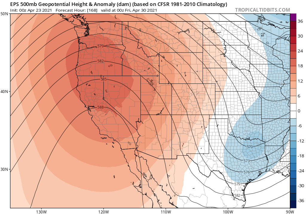
There is multi-model ensemble agreement regarding a shift back toward ridging and above-average temperatures by early May, and perhaps persisting for most of the month. Right now, the ECMWF and GFS ensembles agree that a spring heatwave of some degree may emerge about 6-8 days from now, with hot temperatures inland temperated by a still rather robust marine layer closer to the coast (read: a fairly typical early-season heat event). Longer range outlooks through May suggest a high likelihood of continued below average precipitation and above average temperatures, unfortunately. (Though I will note that, for as long as the unusually cool coastal ocean temperatures persist–which could be a few more weeks at least–places within 30 miles of so of the Pacific Ocean may escape anomalous warmth.)
Discover more from Weather West
Subscribe to get the latest posts sent to your email.