Overview
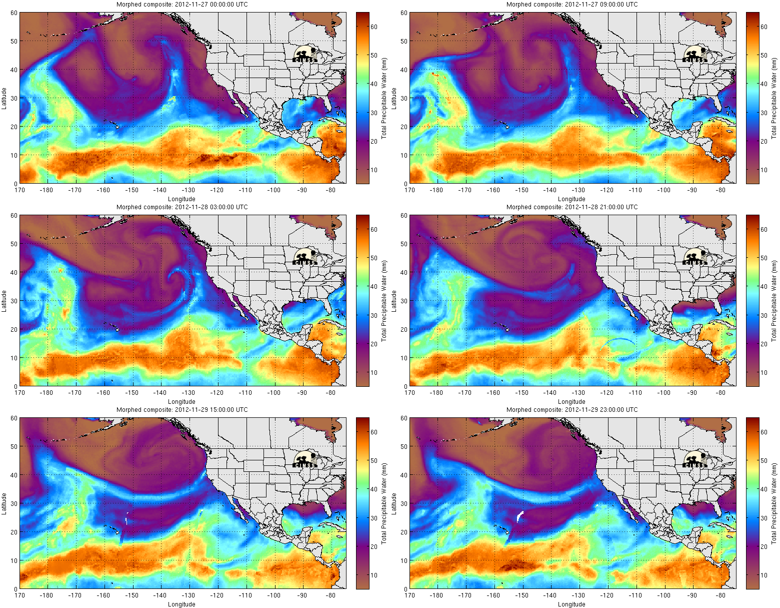
November in California is certainly going to close on a very active note! A very moist and persistent atmospheric river, coupled with two powerful storm systems over the coming weekend, will produce extremely heavy precipitation over a wide swath of Northern California from the Bay Area all the way up to the Oregon border. Flooding is likely in affected areas, initially along small streams tomorrow and then later on the larger rivers by Sunday. Strong winds and thunderstorms will also be possible at times through Sunday afternoon. While rainfall will most likely decrease in intensity next week, a plume of enhanced moisture will continue to stream over the state and produce additional precipitation.
Short Term Discussion
The much-advertised series of increasingly powerful storm systems continues over California at this time. A strong cold front is currently situated across the North Coast region, and is bringing heavy rain, strong winds, and more recently strong thunderstorms to a broad swath of Norcal this evening. Rain from this storm has just reached the Bay Area and will continue to intensify overnight into tomorrow morning. With soils saturated from the quick-hitting but intense rainfall earlier this week, flooding problems will start to crop up overnight on the faster-responding tributaries and in urban areas since the cold front and associated atmospheric river will be slow to move away to the southeast. Winds will not be extremely strong with this storm, but they will potentially be strong enough to start causing minor damage now that soils are completely saturated. Given the recent outbreak of strong thunderstorms along the North Coast and favorable thermodynamic profiles that will persist for much of tomorrow around the Bay Area, I think strong convection is a possibility along and behind the front tomorrow.

The main flooding concern, however, is focused on the Saturday/Sunday system. The models have been very consistent in bringing a very strong and extremely moist storm somewhere into Norcal this weekend and have been generating phenomenal rainfall totals over a broad area (at various points the coarse-resolution GFS has been spitting out aerial averages of 15-20 inches through Sunday). The question has been precisely where the 200-300 mile wide axis of extreme precipitation will set up and cause serious flooding problems. For the past several days, the GFS was targeting the Bay Area with the Saturday/Sunday system; recent runs have shifted the highest precip values slightly north by 50-100 miles into Mendocino County. It’s possible the actual precip maximum could shift another 100 miles in either direction by the time all is said and done; regardless, much of Northern California is slated to receive an amount of rainfall that will certainly cause creeks and streams to overflow and very possibly some of the mainstem rivers as well. I think that event-total precipitation through Sunday afternoon will probably top 20 inches in orographically-favored areas of the Coastal Mountains in Mendocino County and also in the Shasta Drainage region. Snow levels will be quite high through Sunday–generally above 7000 feet–so nearly all of this precipitation will fall as rain and this will contribute to even higher runoff rates than might otherwise occur. And, as with the rest of the systems this week, gusty winds and thunderstorms will once again be possible with the Sunday storm.

Long Term Discussion
There is presently some substantial uncertainty regarding the prognosis for next week. The Sunday storm was initially slated to be the last in the series, with a pronounced drying trend helping the state to dry out during the first week in December. The ECMWF model was the first to suggest that the active pattern might continue into next week, and today the GFS started to trend towards the recent ECMWF forecasts. The 18Z GFS actually brought heavy precipitation back to Norcal by Tuesday, while the most recent 00Z is slightly less bullish. Interestingly, what all the models appear to be keying in on is the continued persistence of our friendly atmospheric river, which by early next week will stretch from just west of the Hawaiian Islands to the coast of Northern California. It’s important to keep in mind that the presence of an atmospheric river does not necessarily mean that extreme precipitation will occur: while the extremely moist atmosphere that characterizes an atmospheric river provides one ingredient necessary for heavy precipitation, a strong synoptic-scale storm system is usually required to generate enough lift to cause significant precipitation (as will occur this weekend). The GFS is not currently indicating the there will be any large-scale storm features to act upon the very moist plume next week, so precipitation forecasts at this time are relatively modest. This is a situation that bears watching, though, since it wouldn’t take much to produce some additional heavy rainfall in the presence of an ongoing atmospheric river event. Stay tuned!
© 2012 WEATHER WEST
Discover more from Weather West
Subscribe to get the latest posts sent to your email.