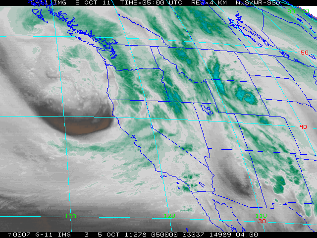
An unusually strong (for October, in any case) Gulf of Alaska storm system is currently moving ashore in Northern California. The associated 500 mb trough is remarkably well-defined for such an early-season storm, and a powerful 130 kt jet is currently rounding the base of the trough off of the NorCal coast this evening. Strong upper-level diffluence, a very moist airmass (PW values approaching 1.5 inches), and an abundance of cold air behind the cold front will lead to a pretty solid soaking across much of the state over the next 24 hours, especially from the Monterey area northward.

Several inches of rain could fall in the favored locations in the mountains and along the coast, while even some low elevation inland areas could see upwards of an inch before all is said and done. Though surface pressure gradients are fairly steep at the moment and 800 mb winds will approach 50 kts near the time of cold frontal passage, I would expect these stronger winds to stay mostly above the surface (except possibly in some stronger convective elements embedded in the frontal precip band). Lapse rates near and behind the cold front are quite steep for early fall in California, and there is indeed already a large post-frontal cumulus field visible on satellite imagery. Isolated to scattered thunderstorms are possible across much of the state by late tomorrow as this unstable airmass slowly moves through the region. Even Southern California will get in on some of the action–it won’t be anything too spectacular, in all likelihood, but it certainly won’t be too bad for the first week in October. After the present storm, though, I expect conditions to clear out and warm up nicely once again by the weekend.
On a related note, the recent and anticipated rainfall in NorCal will probably bring an end to fire season north of about the Monterey Bay Area this week. SoCal is certainly going to get wet, but since we still have the peak of Santa Ana season to get through, it is still too early to call for more than a temporary reduction in fire risk. Enjoy the rain!
© 2011 WEATHER WEST
Discover more from Weather West
Subscribe to get the latest posts sent to your email.