The ocean along the California coast is now record warm, and literally reaching new heights
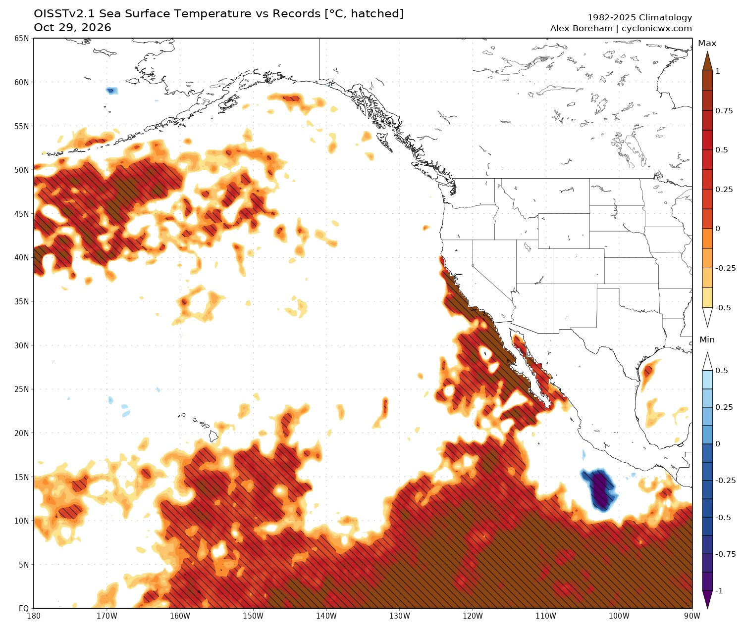
It has been a wild week along the California coast, and not in a good way. Ocean temperatures have now reached record highs along the entire California coast (and on both sides of the Baja California peninsula, for that matter) extending all the way north to Pt. Reyes or even Pt. Arena (in Mendocino County)–a significant expansion from the more SoCal-focused record oceanic warmth in recent months. Significant marine ecosystem disruptions are now being reported along with these balmily warm waters.
Even more dramatic to the casual observer, though, have been the increasingly disruptive and damaging episodes of extreme high tides and coastal flooding/erosion in recent weeks. Over the past few days, southern California ocean water levels reached their highest heights ever recorded in any month–and in parts of northern California, exceeded at least October monthly records (if not more in some locations). Widespread coastal flooding collectively affecting at least hundreds, and perhaps several thousand, structures from the San Francisco Bay Area southward to San Diego has been reported. Widespread inundation of coastal infrastructure, including major roadways and rail lines, has forced their closure; some homes and other structures have been damaged so severely by either battering waves and/or repeated deep inundation that they may be deemed at risk of collapse/total losses. And all of this has been occurring despite sunny skies, light winds, and a lack of king tides: By far, the most important contributor to anomalous and record-breaking coastal water levels right now is the combined effect of thermal expansion of seawater plus a “bulge” in the height of near-shore waters (from the “coastally trapped Kelvin wave”)–themselves the combined result of our extreme El Niño event.
And no–despite numerous and I would argue misleading headlines, this week’s higher-than-average but far-from-extreme astronomical high tides are not traditionally considered “king tides.” There seems to be some conflation between the most common (albeit informal) definition, used by coastal scientists, that reserves “king tide” for the very highest amplitude astronomically-driven tide cycles of the year (which, in California, occur from late November to late January). Lest folks think this is a semantic distinction without a meaningful difference, I would offer this: In California, the true king tides this year–which will occur during three distinct episodes in late Nov, late Dec, and again in late Jan–will be anywhere from 6 inches to 2 feet higher than what we saw this week. That means that actual water levels during the true “king tide” cycles from Nov through Jan could easily be 0.5-1.5+ feet higher than the current record-breaking levels because the effects of thermal expansion and Kelvin waves will persist for months–which is quite concerning, given the substantial impacts we are already seeing. On top of that, if we do manage to get a moderate or strong storm during one of these king tide periods, there could be briefer periods of even greater inundation (with a further 1-2 foot water level increase due to the combined effects of storm surge, freshwater runoff, and etc.). So I promise that I am not nitpicking here–the real reason for the distinction is that present events are not being caused primarily by exceptionally large tidal influence from the sun and moon, but instead by the extreme El Niño event–and even higher water levels are likely in the coming weeks when the sun and moon-driven tides are actually in maximum alignment (i.e, when perigean spring tides occur close to perhelion).
Unusual low-latitude storm will bring Halloween rain across SoCal, and a potentially serious flood threat to the Four Corners region
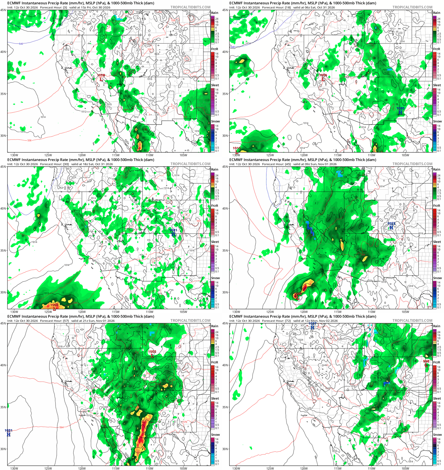
The Halloween weekend forecast has been a tricky one, given the unusual approach from the southwest of an atypical low-latitude low pressure system making a close approach on SoCal. The Pacific jet is not usually strong enough to drive such a robust low pressure system so steadily eastward at this latitude at this time of year, but the odds do increase during strong El Niño autumns (given the increased phasing between true subtropical jet and subtropical branch of polar jet, as we have seen recently).
In addition, record-warm ocean temperatures are adding additional sensible and latent heat into the atmosphere in this region. This means that this unusual low also has some unusual energy sources to tap into in the form of notable convective energy (CAPE), which can facilitate the rapid development of thunderstorms containing heavy rainfall and also (though condensational heating) up the ante on low pressure rates of strengthening beyond what they’d typically be here. (It’s also a data-sparse region, with minimal or no meteorological instrumentation offshore). For these reasons, the models have (understandably) struggled. But they do now seem to be converging on a relatively clearer picture (though it’s still not totally clear how far north the surface low will go, which will have implications for whether SoCal sees mainly light-moderate showers or a somewhat stronger storm on Halloween).
The much bigger story, however, will not be in California but instead points east–especially along the Mogollon Rim and Four Corners region of CO/UT/AZ/NM. This is the same area hit by record-breaking rainfall and a rare severe thunderstorm/tornado outbreak just a week ago under somewhat similar circumstances to what this weekend’s weather will entail. In fact, in some parts of the region (especially far southwest Colorado, southeastern Utah, and the greater Navajo Nation), this rainfall was so severe that it produced major to record-breaking flooding–and many small communities are still actively in emergency response mode.
The concern: This weekend’s storm could once again bring very heavy precipitation to many of the same areas hit hard last week, compounding or even worsening flood impacts. And the NOAA WPC/local NWS offices are raising the alarm–Sunday already has a “moderate” (level 3 of 4) flood risk designation, which is rare to see in this region that far in advance. Last week’s storm was both dynamically impressive and contained record-breaking amounts of atmospheric water vapor–thanks in part to its trajectory over record warm ocean waters west of Baja California more than 10F above average (!). This storm will entrain moisture from exactly the same source region (despite being somewhat less dynamically intense), which may be more than enough to cause additional and/or worsening flood problems in the Four Corners Sun-Mon.
The fact that this pair of back-to-back extreme-to-record shattering rain events across the interior Southwest have occurred during the autumn during (one of the) strongest El Niño events on record is not a coincidence! Such events are known to be amplifed by 1) unusually warm ocean waters in the eastern subtropical Pacific, 2) increased East Pacific tropical cyclone activity, and 3) a strengthened early-season subtropical jet in this region–all of which are much more likely to occur under strong El Niño conditions. We also know that climate change has warmed both the atmosphere and oceans–raising the ceiling on how much moisture can be in the air when it is saturated, as in a storm cloud, and thus also the ceiling on extreme precipitation intensity. When natural climate cycles (e.g., El Niño) align with the effects of long-term human-caused warming (i.e., climate change), this is precisely when we should expect to see an increased possibility of historically unprecedented hydroclimate extremes. There is a real risk we will see something similar unfold, later this winter, in parts of California.
NorCal sees only light precipitation over next week, but more widespread/heavier rainfall is now on horizon by mid-Nov
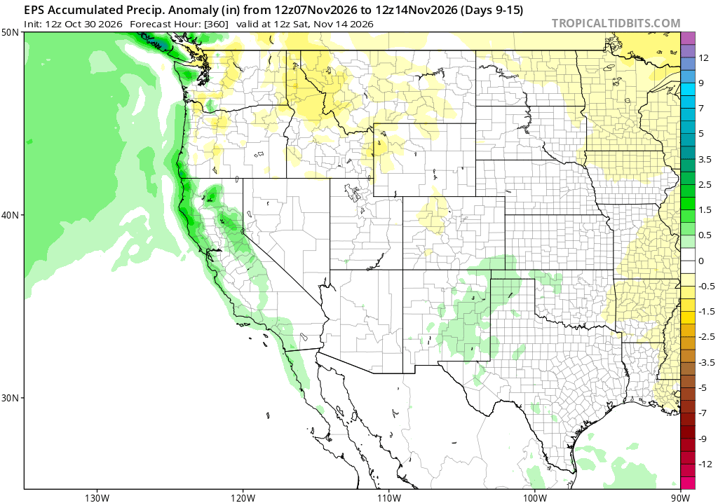
Despite only modest showers (and a bit of high Sierra snowfall) this weekend in NorCal, precipitation over the 10-12 days or so will remain fairly unremarkable. However, there are growing signs that an active Pacific storm track will develop by mid-November–likely driving a series of winter-like storms across the northern part of the state and in some cases bringing the first significant rainfall of the season.
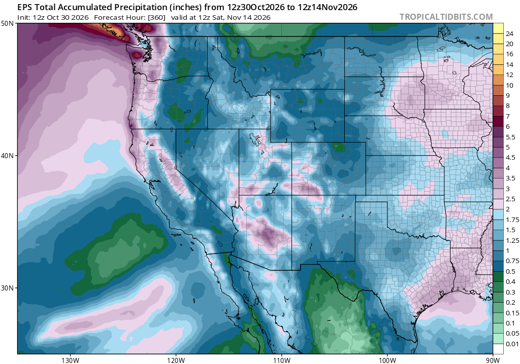
Over the next ~ 2 weeks, all of California (and, indeed, nearly the entire West) will see widespread and at-least soaking (if not heavier) rainfall. I’d expect that fire season is mainly over west of the Continental Divide, and substantial drought relief will continue across much of the interior West (albeit at the cost of severe surface water overabundance and flooding in the short term).
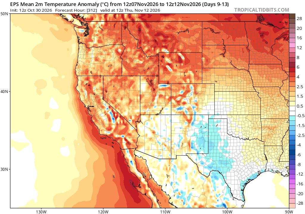
Notably, during this period, temperatures are expected to remain above average nearly statewide despite the increasing potential for precipitation and an active jet stream. That is especially true along the California coast, where the strong influence of now-record warm ocean temperatures will persist and probably even expand farther northward along the coast in the coming weeks.
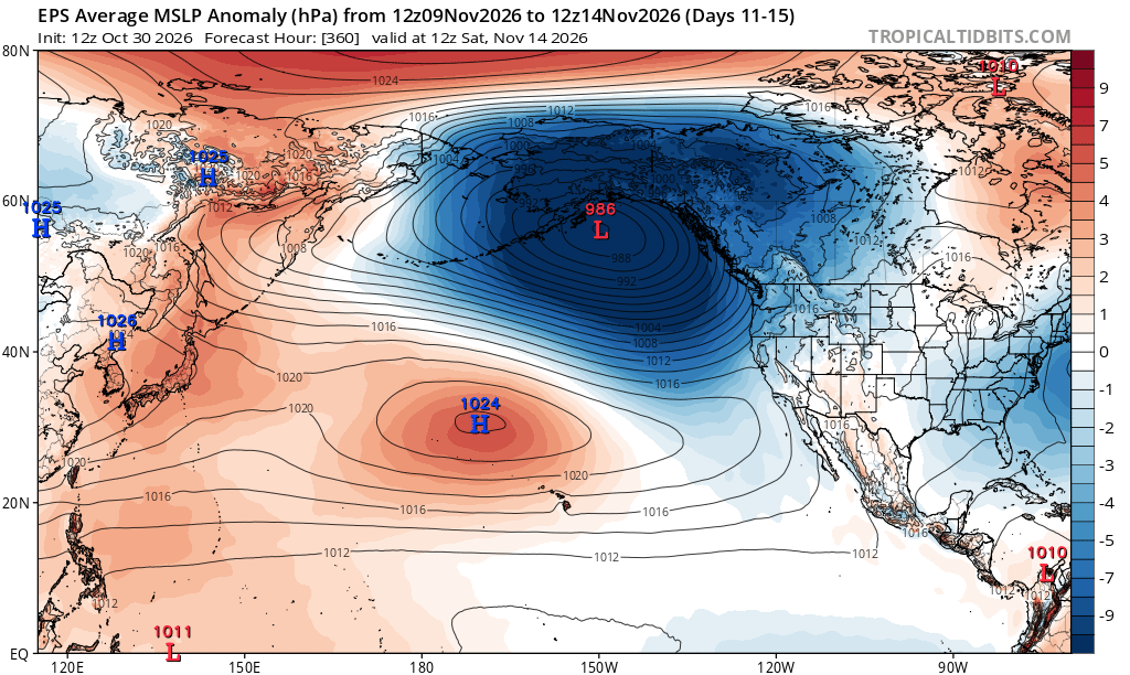
In fact, by mid-month, a distinctly El Niño-like North Pacific pattern is starting to emerge across multi-model ensembles, with an anomalously deep Gulf of Alaska low and anomalously strong subtropical high northwest of Hawaii acting to accelerate and flatten (i.e., make “zonal”) upper level winds and thus the jet stream across the North Pacific. This is a pattern that will eventually favor active California weather, and I think the increasing prospects for NorCal rainfall around Nov 10 are an early indicator of this. There is a modest tilt in the odds toward a wetter than average November due to the extreme El Niño event, but the main El Niño teleconnections don’t really get underway until later–usually December or even January–so this is actually a pretty early start for a classically El Niño-like pattern to be showing up in the medium term forecast.
El Niño, already extremely strong, will probably intensity even further into Nov-Dec; CA impacts will increasingly emerge
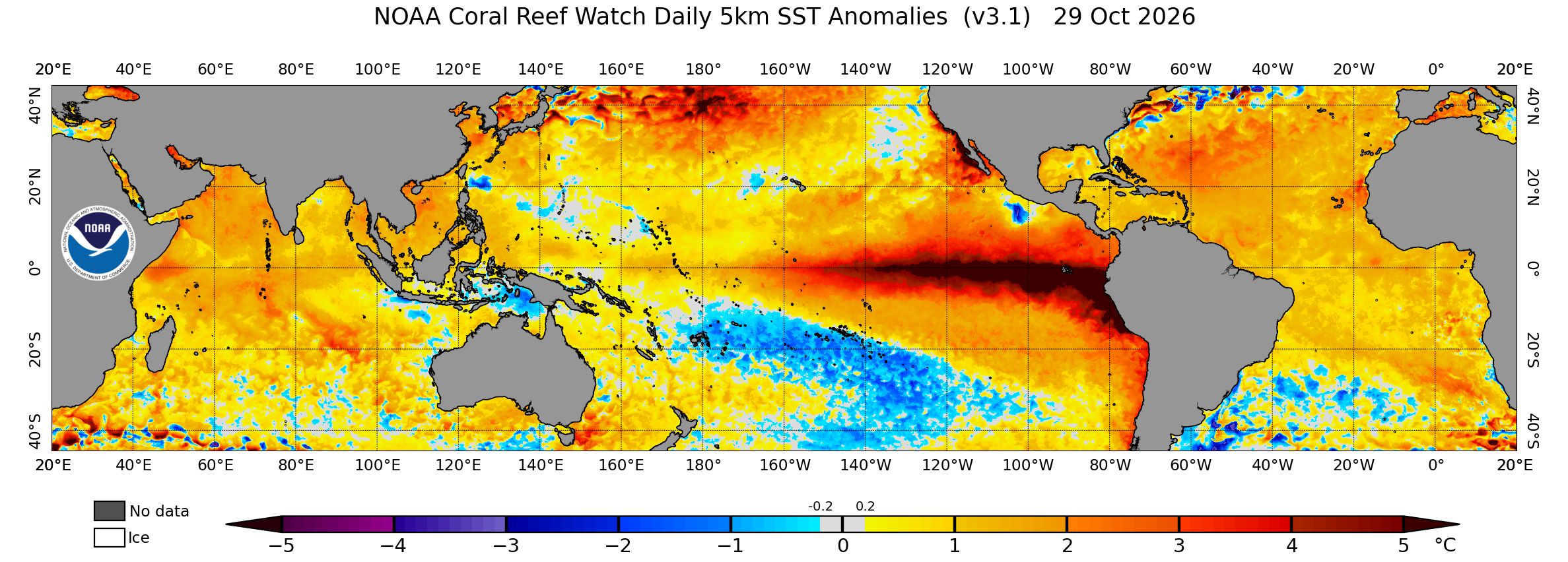
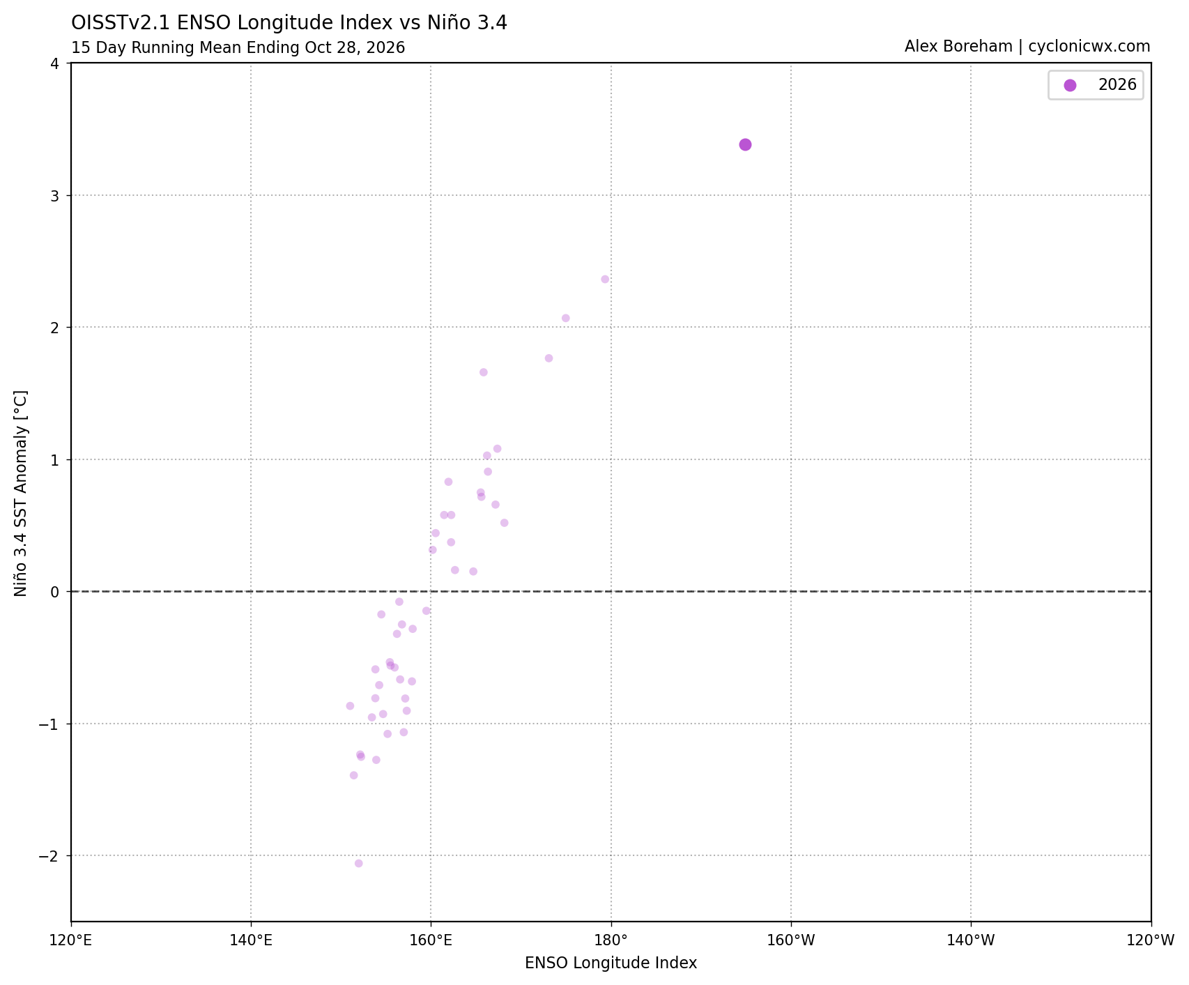
El Niño is, of course, already present and already very strong by almost any measure. In fact, depending on the exact measure, it’s already approaching or exceeding historical records for both traditional intensity perspective (as defined from a surface ocean warmth perspective) and from a “North Pacific hydroclimate impacts-specific” perspective (as defined by the ENSO Longitude Index, which emphasizes the position of the most anomalously warm waters). As of this writing in late October, we have never measured an El Niño event with tropical eastern Pacific waters as warm as they are today this late in the season–nor have we ever measured an eastward shift in the tropical Pacific warm pool as dramatic as we are currently witnessing. By these metrics, this El Niño is already off-the-charts.
And all indications are that it still hasn’t peaked–we likely have at least a few weeks, and perhaps as many as a couple of months, of strengthening left to go. And as discussed previously, El Niño’s peak impacts in California will lag El Niño peak intensity even further–with greatest coastal flood risk from late November through late January and greatest inland flood risk from December through March. I’ll continue to provide regular updates on El Niño as we begin to experience more direct impacts through the coming weeks and months, but at this juncture I doubt the big picture forecast will change much as the extreme El Niño event itself is essentially “locked in” at this point. There is a high risk of increasingly disruptive and damaging coastal inundation, and also a growing likelihood of increased inland flood/landslide risk from heavy precipitation later this season. Once the November seasonal model update cycle has completed in about a week, I’ll have another dedicated social media thread and YouTube livestream to discuss. Stay tuned!
Finally: If you’re interested in a longer-form conversation to listen to this weekend, I joined the LA Times Studio’s California Politics Podcast to talk about our extreme El Niño event and its broader implications for the Golden State.
Discover more from Weather West
Subscribe to get the latest posts sent to your email.