June was mostly warmer than average in California, but without exceptional heat and with robust coastal marine layer; large and destructive wildfires explode across Southern Rockies amid strong winds and extreme drought
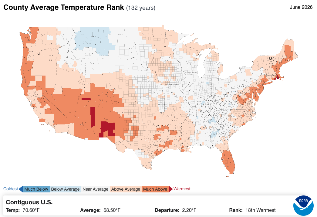
June was a relatively warm month across much of the western U.S. compared to long-term averages, though record warmth was limited to the Four Corners region. Much of the California coast, despite some warm and sunny days, was relatively cool under a persistent marine layer–though, notably, temperatures even here were *much* warmer than during recent “June Gloom” events between 2023-2025 despite the fog and stratus as near-shore ocean temperatures warmed. Early July has actually been cooler than much of June in some parts of the West, though that trend will reverse (quite dramatically in some places) in the coming days.
Far more notable than June temperatures was the high degree and severity of wildfire activity across the interior West, including Washington and Oregon east of the Cascades and especially Utah and Colorado. Numerous fast-moving and in many cases high-intensity fires burned amid unusually windy and dry (but not necessarily warm conditions)–which unfortunately overlapped almost precisely with the same higher elevation regions that saw record-warm winter conditions along with record-low spring snowpack this year as well as worsening long-term drought. Some fires, many of which are still active, have approached or surpassed 100,000 acres; over 1,000 structures have been lost cumulatively, with the largest losses in Colorado and Utah; three firefighters were also killed in a tragic burnover event along the Utah/Colorado border at the peak of the wind event.
The North American Monsoon (which, as a reminder for folks, refers to a seasonal reversal in wind patterns that often brings an increase in humidity and/or precipitation–but is not, in itself, a singular precipitation event) is late this year, but onset is now on the horizon, and late starts do not necessarily portend poor outcomes. And it can’t come soon enough, given the current wildfire situation across the Great Basin and Southern Rockies/Four Corners region, as well as the severe ongoing multi-year Colorado Basin drought.
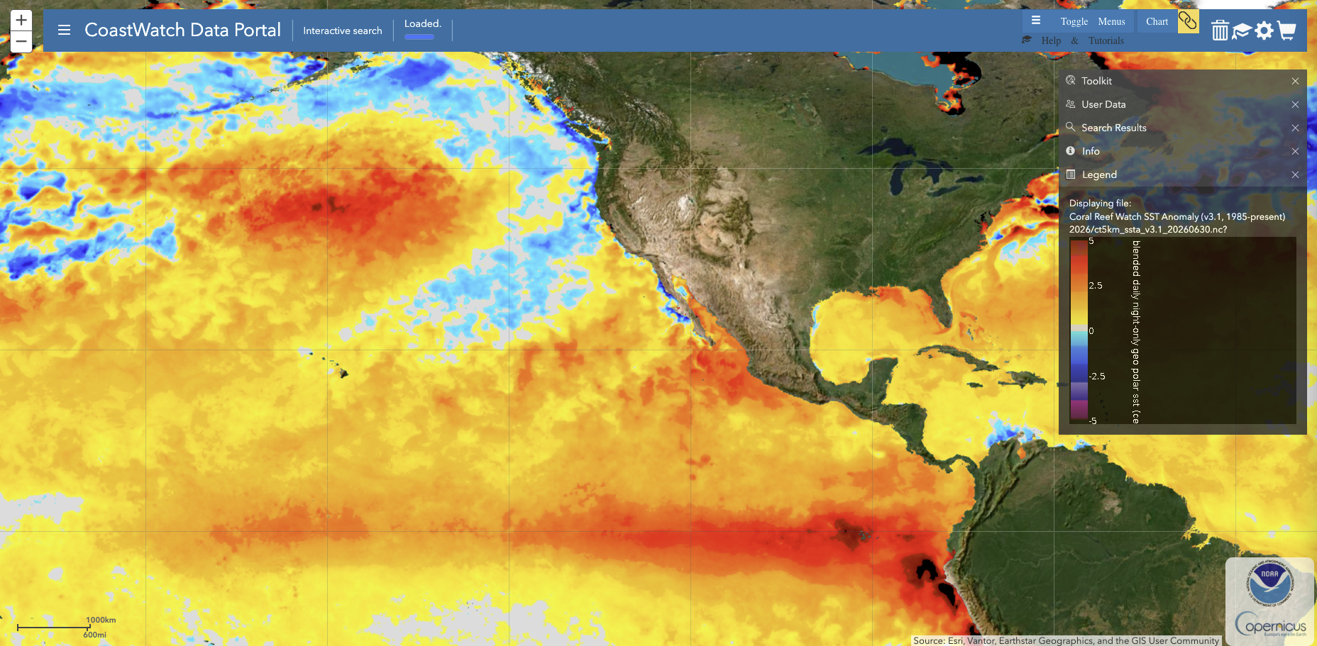
An extreme to record-breaking marine heatwave, meanwhile, continues across much of the subtropical northeastern Pacific Ocean despite a region of persist cool water right along and just offshore of the Pacific Coast from about Mendocino County northward into British Columbia.
A massive “heat dome” will build from Pacific SW eastward to Ohio River Valley
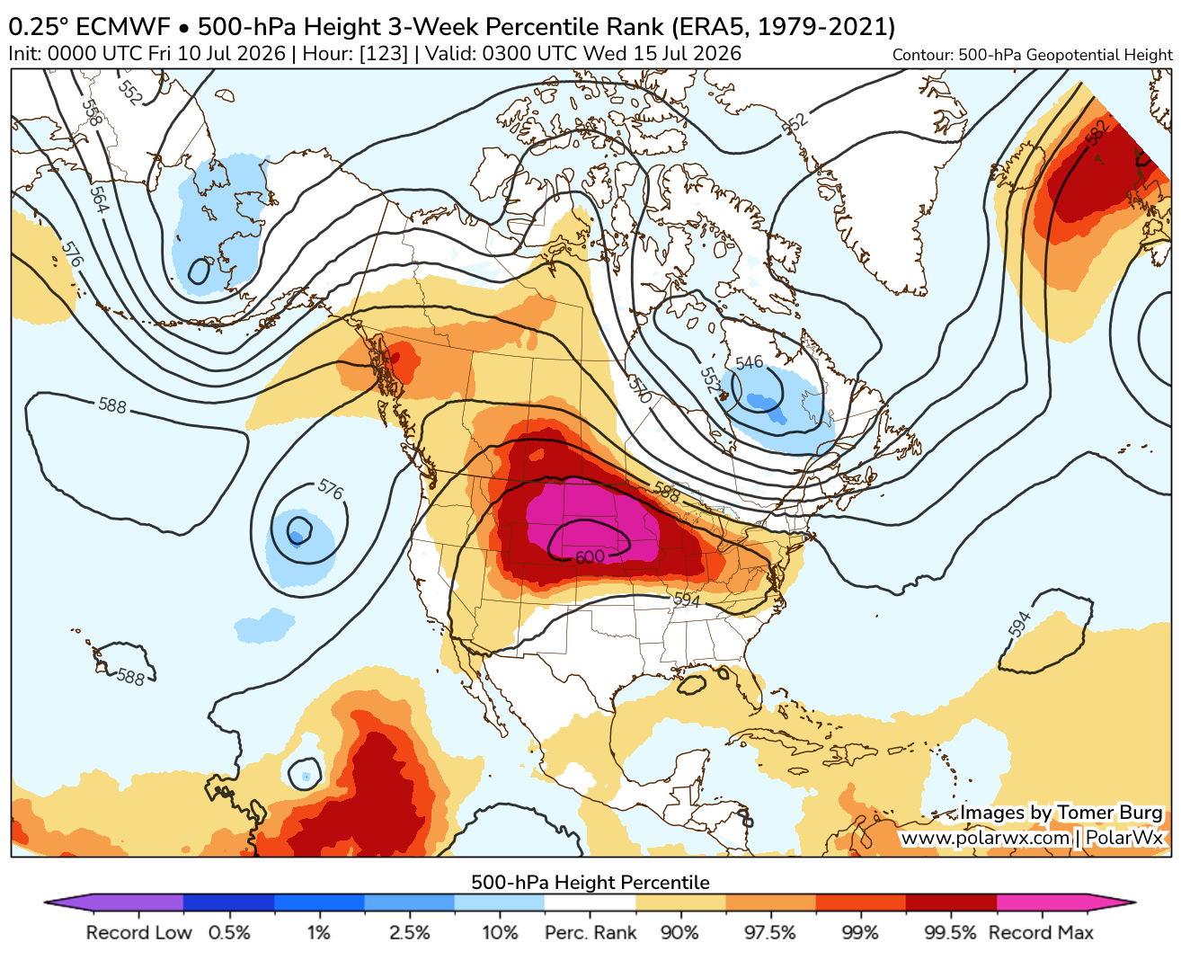
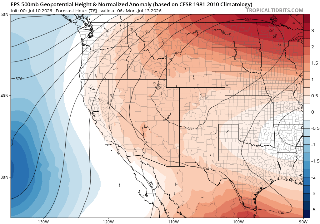
An extreme, and likely record-breaking, blocking ridge will develop over the Central U.S. by Sunday and persist for most of next week. This will bring record heat (see below) to some parts of the country (though probably not CA), and will also (in conjunction with an offshore low pressure system) bring increased humidity, as well as a chance of thunderstorms, to much of California. While just as extreme as initially indicated, the ridge axis is now expected to align about 500-1000 miles east of its originally predicted location–so the most extreme heat will, accordingly, be shifted eastward as well. It’s quite rare to see a ridge this broad centered in the north-central U.S. this time of year–this position allows it to affect the weather, albeit in different ways, across nearly the entire continental United States.
Record heat likely from interior West to Upper Midwest, with more moderate (but increasingly muggy and persistent) heat across CA and the SW
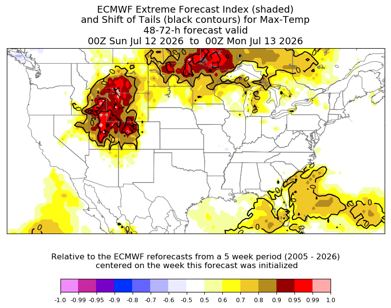
This extremely large, persistent, and intense “heat dome” associated with the blocking ridge will likely bring record-breaking temperatures across a wide region extending from the eastern Great Basin eastward to the Upper Midwest (so from Utah to Minnesota). Countless daily records will be set, but quite a few July monthly records will also be at risk and even a few all-time, any month records. Part of the reason for this is that the most extremely anomalous warm air temperatures during this event will be several thousand feet up in the atmosphere versus near sea level, so higher elevation locations could see some exceptional warmth (Salt Lake City and Grand Junction, for instance both could tie or exceed their all-time records). Overnight minimum temperatures in some high-mountain locations in the Southern Rockies will not drop below 70F for several days, which in some ways is even more extraordinary.
This ridge position, though, is somewhat farther east than originally anticipated (Dakotas vs Utah/Colorado). This means that California and the West Coast won’t see extreme heat during the initial stages of this event, which would have been possible if the ridge center was closer. Still, it will be much warmer than it has been recently and most of California away from the immediate NorCal coast will see an extended period of above-average hot temperatures. More significant, however, will be the far more anomalous elevation of overnight temperatures during this period. In fact: it is possible that few, if any, daytime temperature records are set in California during this event–but I would expect quite a few nighttime record warm minimums to be set, especially by later next week. Some parts of the San Joaquin Valley might not drop below 75-80F, even at night, for many consecutive days; much of SoCal, even close to the coast, will struggle to drop below 70F beginning early next week. This, combined with increasing humidity (see below), will probably be the most substantive heat-related aspect of the event (though the North Coast may still escape it completely). And it will probably also be persistent: despite a lack of record highs, it’s possible that many places could see a long (10-14 day) unbroken stretch of above average temperatures, including triple digit heat inland–so it’ll drag on.
Monsoon moisture surge on west side of ridge across California & SW, with potential for dry-to-wet thunderstorm activity
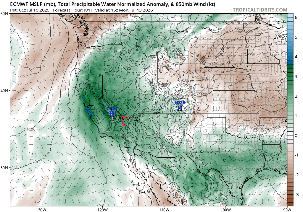
Sandwiched between a fairly deep offshore low and a very strong well-inland ridge, California will see deep southerly or southeasterly flow in the coming days. This is a classic pattern for monsoonal moisture advection in the region, and that’s exactly what’s going to happen over the weekend. A very moist plume (with moisture concentrated at mid-levels of the atmosphere, versus at the surface) will move across the state from south to north. Sat and Sun, it may bring some mountain/desert thunderstorms, a few of which could make it west of the mountains/to the coast in SoCal. Then, later on Sunday into Monday, the slug of moisture moves into central and northern California. As it does so, it will move into a slightly more favorable position relative to the offshore low (in terms of vertical stability and slight upper diffluence) to potentially generate some elevated convection. This means that there is at least a low risk of some mostly-dry thunderstorms Sun-Mon from the Monterey Bay Area northward–and they could occur in coastal areas as well as (more likely) over the NorCal mountains.
Uncertainty with this setup is high, which is not uncommon based on historical experience. There’s high confidence that mid-level moisture will be more than adequate for mid-upper level cloud formation, including altocumulus with lots of virga (i.e., evaporating rain). But the real questions are a) how much atmospheric instability there will actually be (not a lot, but sometimes it doesn’t take much for shallow yet lightning-generating mid-level convective clouds in California), and b) will this instability overlap with maximum moisture levels and/or some external “trigger” (like an as-yet unresolved vorticity maximum or other subtle mesoscale feature). In these kinds of patterns historically, the global and even high-resolution/convection-resolving models usually don’t have a good handle on situations like these, so their explicit precipitation/lightning depictions are not always reliable indicators. The overall pattern looks moderately favorable for some elevated convection/dry lightning across central/northern CA Sun-Mon; beyond that, it’s difficult to say more and I’m not sure we’ll really know until things start showing up on satellite/radar 6-12 hours in advance. It is worth noting that the ECMWF does explicitly develop some very light convective precip over and near the SF Bay Area, which is bit of a positive indicator that something might pop up.
What is my overall assessment? There’s a pretty good chance of some thunderstorms over the SoCal mountains Sat-Sun and the NorCal mountains Sun-Tue, and there’s a good chance that some dry lightning and subsequent wildfire ignitions will occur here. These may not be widespread, but they probably will materialize. In coastal SoCal, there’s probably a ~20% chance of some (mostly dry) thunderstorms or brief gusty sprinkles over the weekend. In NorCal, including SF/Monterey Bay Area and northward, there’s probably about a 20-30% chance of mostly dry thunderstorms Sun-Mon that would probably yield at least a few wildfire ignitions if they occur. But vegetation dryness is not especially elevated right now in the Bay Area or in the Coast Ranges, so that would substantially mitigate subsequent fire behavior even if there are some lightning fires. In the far NorCal mountains and northern Sierra, the situation is a bit different given much warmer/drier recent conditions and a record-early snow meltout this year, so the risk of larger/more consequential lightning fires will be greater in this part of the state (and the lightning might also be preceded and followed by hot and breezy conditions up there, too). Greater concern might arise in the interior Pacific Northwest Mon-Wed if dry lightning can occur in the Cascades and eastward, since this is a region currently experiencing much more severe antecedent drought than anywhere in California.
Late July pattern looks warm-to-hot and unusually humid across California; subtropical/tropical moisture incursions possible but hard to time in advance
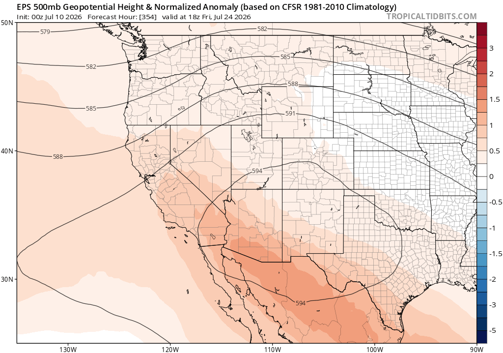
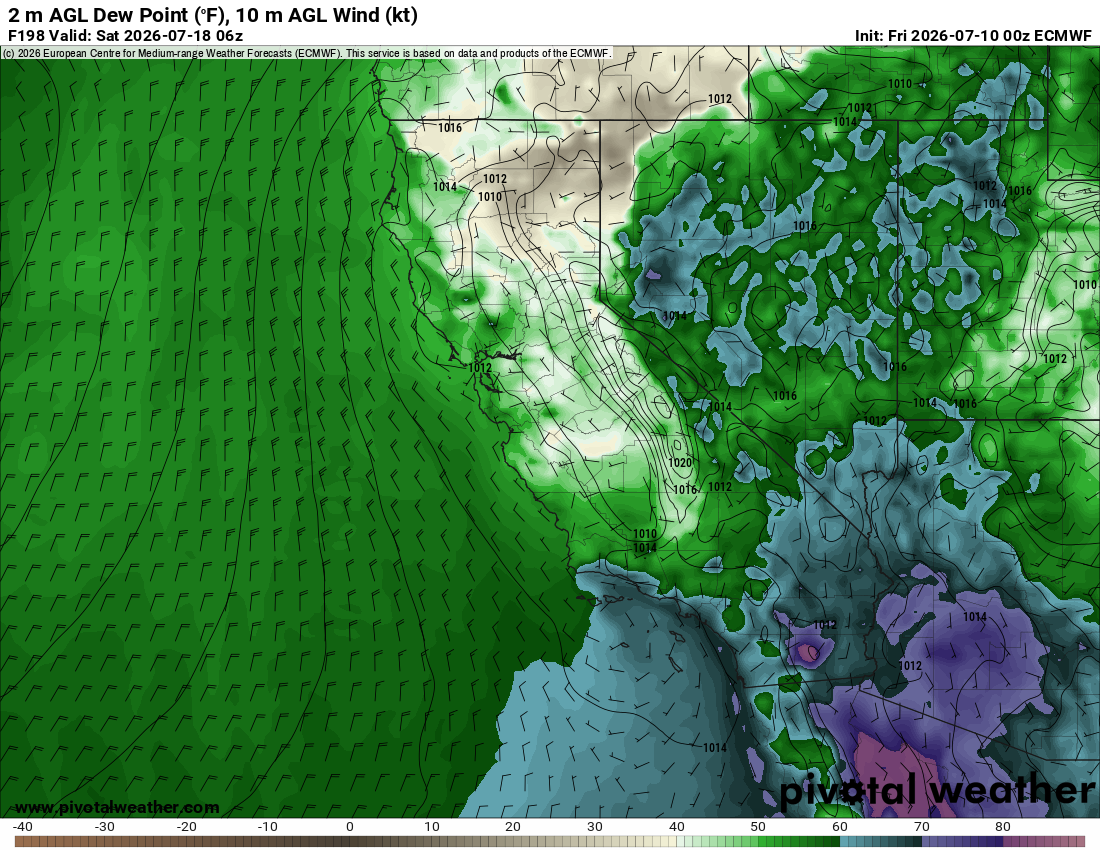
After the giant “heat dome” weakens on its eastward flank, its central axis will likely return to a position, near the Four Corners, that is more typical for mid-summer. This is a classic “monsoon high” pattern, and will finally allow the monsoon to kick into higher gear across the interior West (bringing, hopefully, some much needed rain to the Colorado Basin and Southern Rockies). It will, however, remain both broader and stronger than usual–and especially so on its western flank. This includes the portion extending over California and northern Mexico. The result? Warm-to-hot temperatures in general, with well above average heatwave conditions possible across inland areas. But even more notably, perhaps, will be the persistent and at-time humid southeasterly flow that will be present across California. This will make conditions at ground level increasingly muggy over time, and will likely bring at least 1-2 additional opportunities for at least mountain/desert thunderstorms (which could, at times and at TBD intervals, spill west of the mountains in SoCal and/or make it to NorCal and beyond). As the month goes on, convection will likely shift from being mainly dry (this week, with considerably fire ignition risk) to mostly wet (with some, but reduced, fire ignition risk) because surface moisture will be on the increase. In fact, the lastest predictions suggest that surface dewpoints in SoCal could become downright oppressive by mid-month, with 65-70F+ dewpoints bringing tropical-like humidity and nighttime temperatures that rarely drop below 70F–even along the beaches (could even see some 70 degree fog at times!).
During this period, it also appears that the East Pacific hurricane season will be heating up considerably, and a handful of model ensemble members currently bring tropical storm remnants fairly close or over California. While the odds remain low for now, it’s something to keep an eye on as it could be a bit of a “wildcard” source for enhanced showers/thunderstorms in CA if it occurs.
In a timely coincidence, recent peer-reviewed research has highlighted the growing possibility of consequential hydrologic impacts from landfalling tropical cyclones (TCs, aka tropical storms/hurricanes) in California due to climate change. In the past, I’ve informally mentioned the plausibility that warming ocean temperatures would increase the frequency and potential magnitude of “tropical remnant event” weather set-ups in California, and even the more distant but real possibility of actual intact tropical storm (or weak hurricane) landfalls in southern California. This new research is the first that I’m aware of that considers this question directly, and the answer is pretty clear: warming oceans will, most likely, increase the likelihood of such events bringing heavy precipitation to southern California during the late summer and autumn months. The main risk here would be from flash floods and debris flows in mountain/desert regions, but such events can also bring other major impacts to the much more heavily populated coastal SoCal metro areas (and also, on the beneficial side of things, substantial fire season mitigation). The most dramatic recent example of an event like this is Tropical Storm Hilary in August 2023–which triggered the first-ever Tropical Storm Warnings for California–and although it did not ultimately make landfall as an intact TC, it did bring widespread heavy and in many cases record-breaking summer rainfall (including in Los Angeles) as well as widespread flash flooding across CA’s SE deserts, and also an early end to fire season.
Why is this new research so timely? Well, as I noted in my last blog post, the odds of tropical remnant events (or even an intact TC landfall) are notably higher during a strong or very strong El Niño event due to the combination of warmer oceans, higher lower tropospheric humidity, and less-unfavorable upper-level wind shear patterns over the tropical NE Pacific Ocean. I still believe the possibility of “interesting” TC-influenced weather is considerably higher in 2026, due to the rapidly developing El Niño event, than it would be relative to the more gradually increasing baseline caused by long-term ocean warming.
El Niño continues full steam ahead; most likely outcome is now a very strong (i.e., “Super El Niño”) event by peak in autumn/winter, with growing CA impacts starting mid-late summer
El Niño is already here, and it’s continuing to strengthen rapidly. Ocean-atmosphere coupling is now clearly underway, and additional strong Westerly Wind Bursts are occurring. All systems, it appears, are “go” for a big event–and all available modeling tools are consistent with this. In fact, since spring, real-world ENSO conditions have consistently tracked near or above the ensemble median–meaning that predictions thus far have been pretty good. And with the July monthly update cycle, the ensembles are coming in even higher with their predicted El Niño peak magnitudes (which will likely occur sometime between Oct and Dec): Regardless of whether one uses the newer Relative Oceanic Niño Index (RONI, intended to account for spatial pattern and partially subtract out global warming effects) or the original ONI, the multi-model median is now suggesting a peak well into record-breaking territory. In fact, even considering the broader range of outcomes across the entire distribution of predicted outcomes, it’s clear that a very strong (aka “Super”) El Niño event is now the single most likely outcome (> 80% odds using RONI, > 90% odds using ONI). That is, unquestionably and by a wide margin, the most dramatic ENSO prediction of the modern era–and it could well end up becoming the strongest El Niño event on record (though that, at least, is far from guaranteed).
In my last post, I discussed in detail what I think all of this means for California beginning mid-late summer and continuing through next winter. Nothing has changed this month, except the odds of a very strong event have further increased and we’re now about a month closer to potential peak impacts. I would expect the El Niño-related ocean warming and local sea level increase to begin to increase by late July or early August, and amplify thereafter (what we’re seeing now is still, primarily, related to the PMM-related marine heatwave that started in the winter–but we may also be starting to see the early effects of El Niño along Baja CA and perhaps the SoCal Bight). It’s important to remember that a strong El Niño event does not, in fact, portend a higher likelihood of extreme daytime temperatures in California during summer or autumn; instead, it greatly elevates baseline temperature and humidity (especially along and near the coast)–making for warmer nights and much more humid heatwaves when they do occur. That increased mugginess will become much more prominent, especially in central and southern CA, in the coming days and weeks–and will probably extend into at least portions of Northern California by August.
Please consider filling out a brief survey regarding my weather and climate communication activities!
As part of my unique role at University of California Agriculture and Natural Resources (UC ANR), I’m collecting information from folks who have interacted with my (ever-expanding) portfolio of weather, climate, wildfire, and natural hazard-related communication activities. The primary goal of this sampling is to ensure I’m reaching the widest possible audience of people across California (and beyond). This short survey runs annually, on a recurring October-September cycle. If you haven’t filled out this year’s survey yet (since October 2025), I’d greatly appreciate it if you could take a few minutes to do so–here’s a direct link. Thank you!
Discover more from Weather West
Subscribe to get the latest posts sent to your email.