Continued ocean warming brings increasingly warm and humid conditions to coastal SoCal
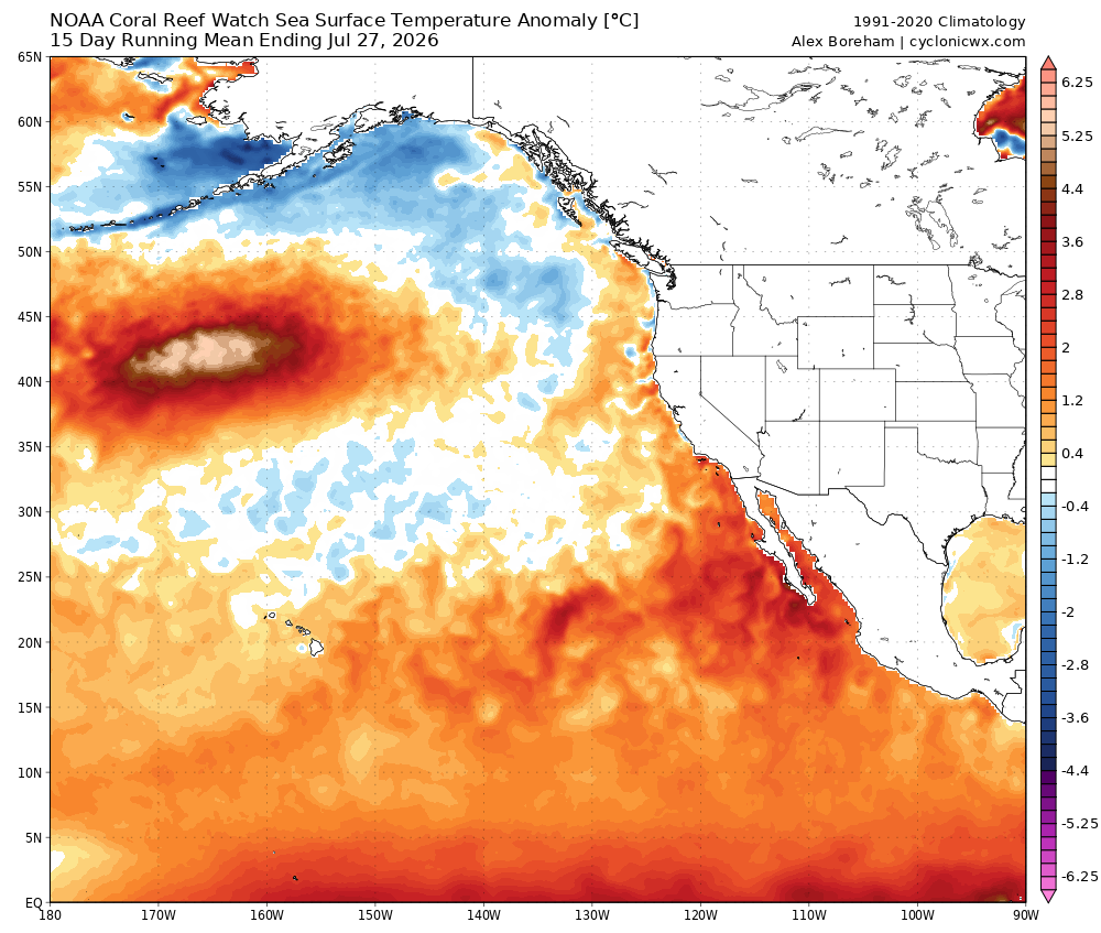
In recent weeks, the Pacific Ocean along the immediate Pacific Coast has continued to warm. Earlier this year, I mentioned that this was not yet due to El Niño because…well, El Niño had not developed yet (and was, instead, related to other patterns of Pacific variability). But now, El Niño has developed–and is already well into “strong” territory by almost any metric even though it won’t be officially declared as such until it sustains this intensity for several months. And accordingly, El Niño is now and for the rest of the calendar year going to be an increasingly significant driver of elevated near-shore sea surface temperatures (SST) along the California coast. This is especially true in SoCal, but will also become increasingly prominent along the central and northern CA coast by later summer into autumn. In fact, at present, near-shore ocean temperatures in some portions of the SoCal bight are near or at record-warm levels–and may rise yet further in the weeks to come.
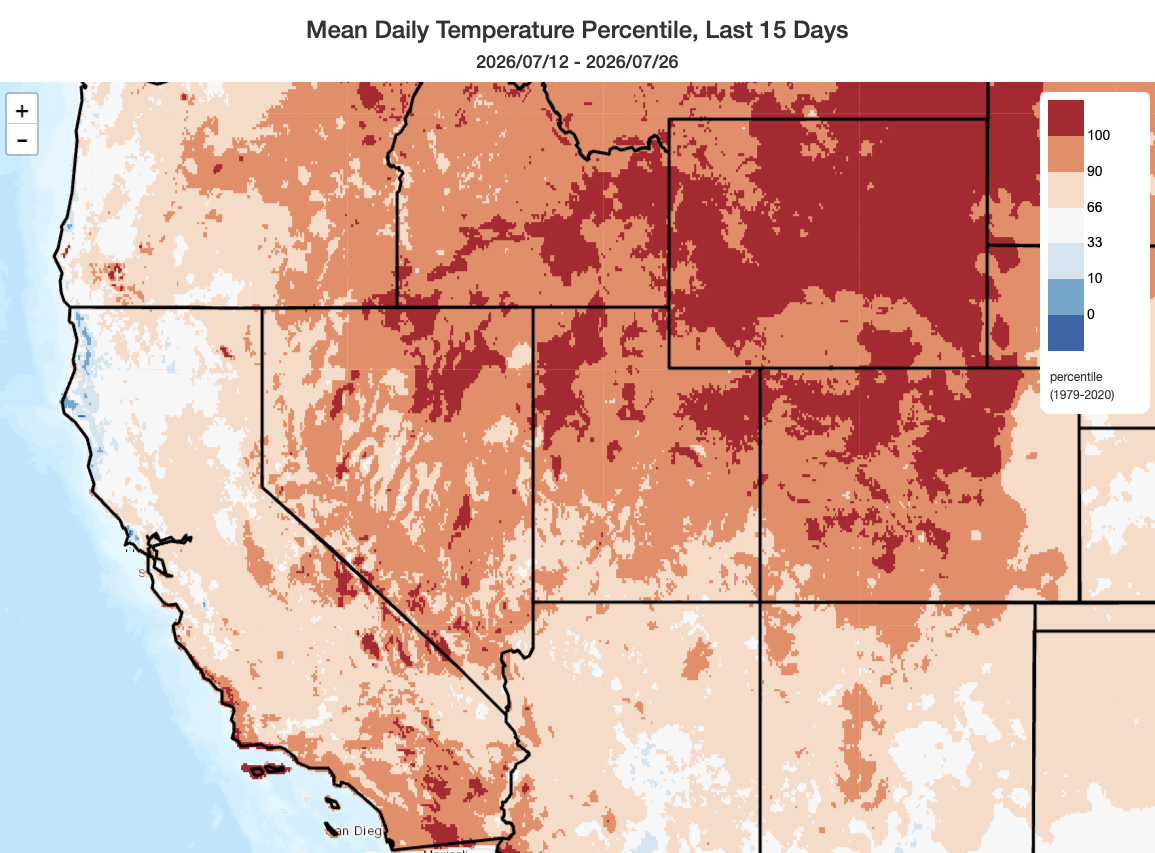
Accordingly, temperatures along the SoCal coast have now been consistently above average in recent weeks. This warmth has not been apparently along the North Coast, though it may eventually arise there too as SSTs warm in a northward fashion. Meantime, the last two weeks have been record-warm across much of the interior West, including parts of the Great Basin as well as the central Rockies
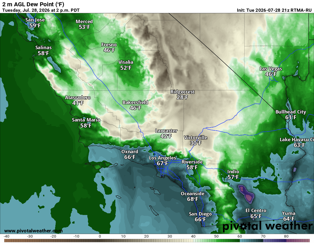
Also, as anyone living, working, or simply breathing in any of the SoCal major metros can attest–it’s very muggy out there. Tropical-like dewpoints near or even locally above 70F have been common across coastal SoCal as ocean temperatures warm, and this is starting to have a significant impact on human health as it greatly amplifies the physiologic burden of heat events that would otherwise be more moderate. This is part of the reason why the National Weather Service in Los Angeles has been issuing various heat advisories and warnings despite far-from-record-breaking temperatures: the humidity really is making it feel hotter than the temperature would suggest, and that’s not typical for California. Far from a dry heat! Farther north, conditions will not be nearly so humid as in SoCal though there may still be episodes of muggier interludes as warmer air makes it northward and inland through coastal gaps, and as occasional monsoonal surges occur (see below).
A double-peaked heatwave is likely across SW US late Jul into Aug, including record-breaking ridge strength and temperatures in some locations
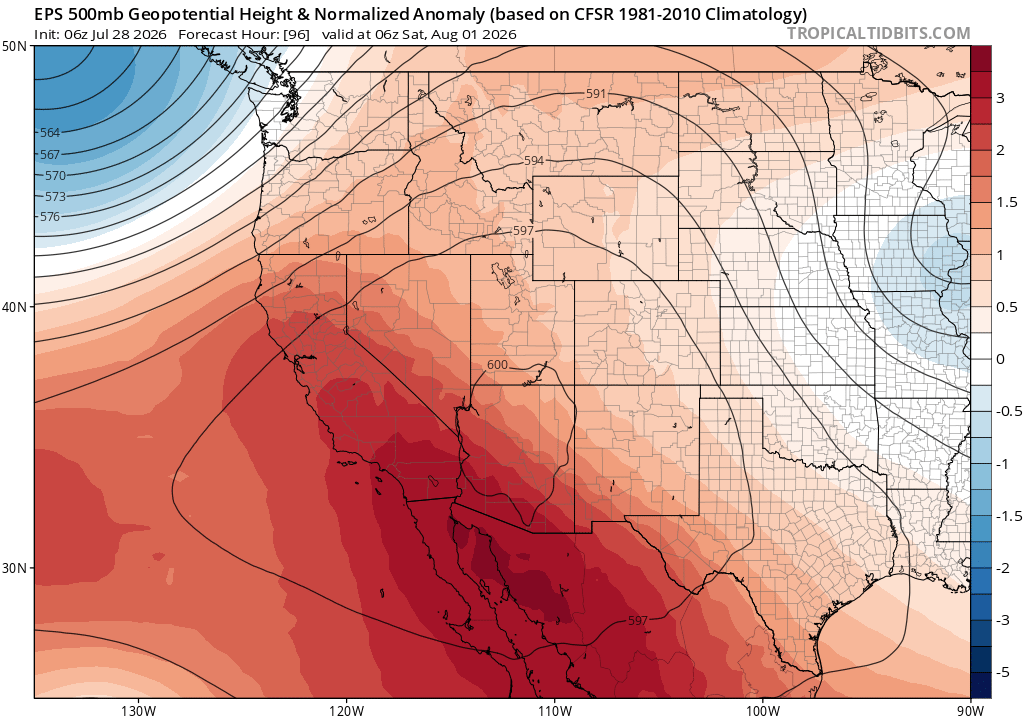
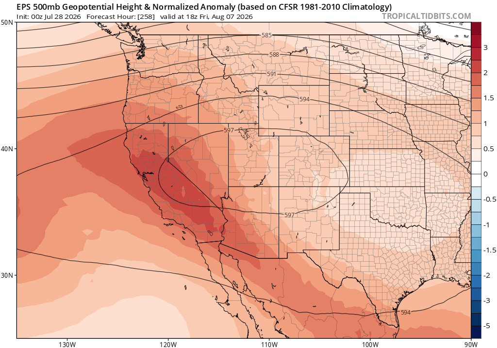
A major, and double-peaked extreme ridging and heatwave event will develop starting later this week across California, adjacent Pacific, and broader Southwest. The peak of the first wave will likely be this weekend before modest cooling early next week; however, a secondary surge in both extreme ridging and in some cases intense heat will likely then begin again around the middle of next week and potentially persist for some time thereafter.
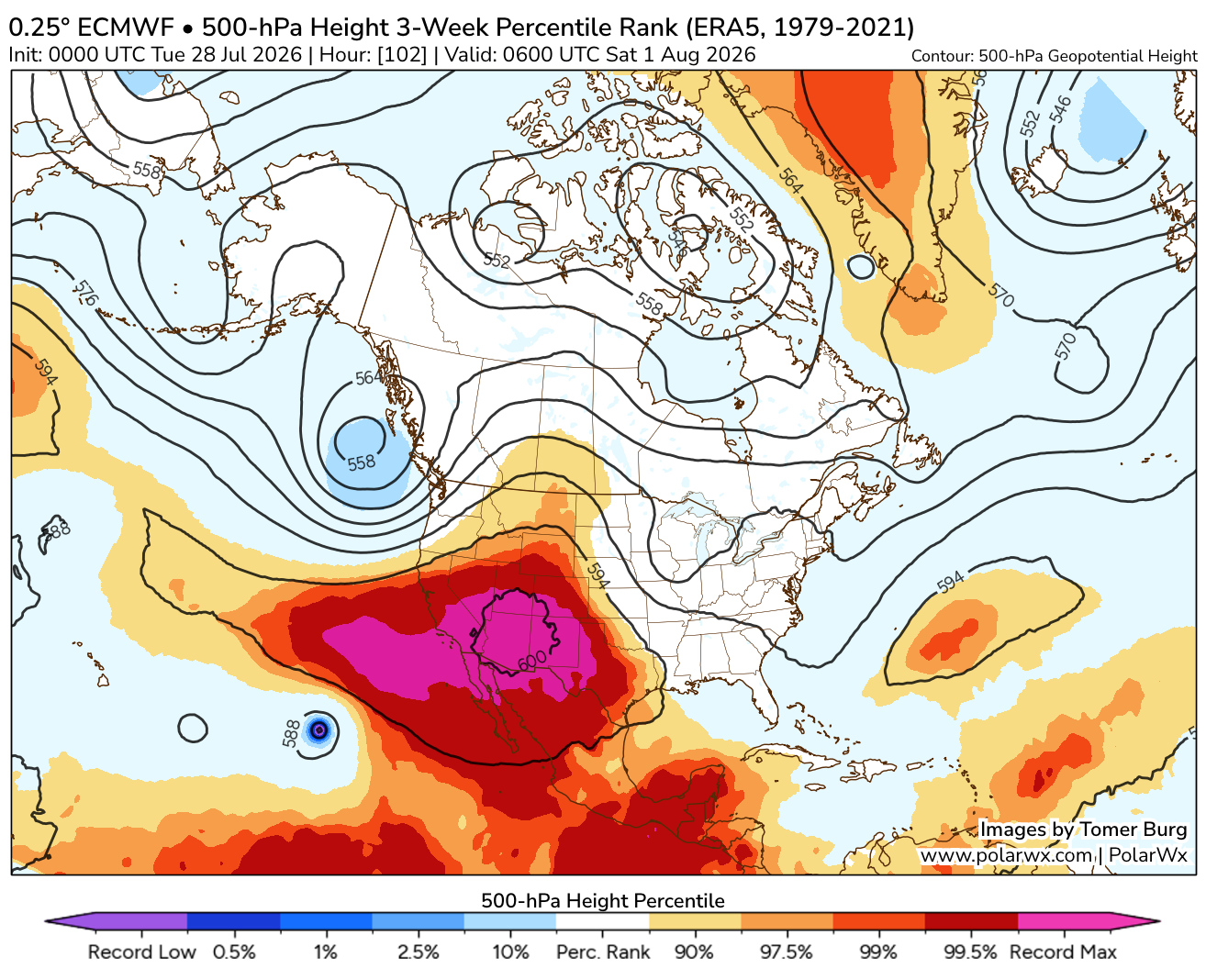
I’ve already had folks ask: What do you mean by an “extreme” ridge? Is it really that big a deal? Well, to answer that question directly, I’ve added a couple of data visualization plots below to tackle the question. In short: the ridge this weekend, which will be centered directly over southern California and Arizona, will likely have the highest 500mb geopotential heights (GPH) on record for the mid-July to mid-August period. (As a reminder, GPH is a measure of the vertical thickness of the atmosphere, and it’s directly proportional to the mean temperature of that layer–so “record high 500mb GPH” pretty directly means “highest vertically aggregated temperatures in the lower half of the atmosphere ever observed at this time of year.”) That’s especially notable because it’s around the time of year when the most extreme ridges in this part of the world most often occur (so the bar is genuinely high). And, remarkably, model ensembles suggest there is a pretty high likelihood of another record-breaking GPH episode later next week, this time centered a bit farther north.
Record 500mb GPH, notably, does not directly translate to record-breaking temperatures at the surface (i.e., where we live). That’s because anomalously warm temperatures can occur well above the surface, influencing this vertical statistic. Even so, model ensembles suggest a pretty high likelihood of record-breaking surface temperatures across portions of the West this weekend–especially across the Great Basin and Central Rockies (yes, once again) but also across interior portions of southern California and Arizona. So while I don’t expect Earth-shattering daytime temperatures across most of California, some records may be set away from the coast in SoCal (and just about everyone, except for a few near-coastal reprieves, will get quite hot). As with the last heat event, overnight warmth will be more anomalous than daytime heat across much of California–and quite a few locations in coastal SoCal could actually set record “warm minimum” overnight temperatures next week as the airmass struggles to cool below 70-75 degrees, even at night. There’s also a chance that Death Valley could make another run at a new record for reliably-measured hottest temperature on record globally (130F), though that’s uncertain and will be subject to microclimate details within the Valley itself this weekend.
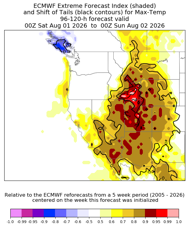
As earlier noted, this will be a long-duration heat event for the Southwest and also for most of California. In fact, in central and northern California, it now appears that the hottest individual days might not even occur until over a week from now. The exact magnitude of this second peak remains TBD, but since the ridge will begin to expand further offshore and into the Pacific NW during this period I would not be surprised to see some “overperformance” (i.e., temperatures ending up somewhat higher than the already high but not yet record-breaking values currently in the forecast).
Also: Except for SoCal, where very warm ocean water temperatures are starting to limit how much cooling can occur even at night, the immediate coast of NorCal might escape notable heat during at least the first wave of this event. But during the second wave, there will probably be a greater likelihood of at least weak offshore flow that brings hot temperatures much closer to, and possibly all the way to, the coast. During long-duration and broad ridge-driven heat events like this, there are often a couple of days that end up much hotter than predicted along the coast due to quite subtle pattern variations that allow very hot air inland to spill westward. These often aren’t easy to predict more than a couple of days in advance, so I’d keep an eye out for this happening in SoCal this weekend (first wave) and anywhere statewide later next week (second wave).
Hurricane Genevieve may “amp up” ridge and heatwave this weekend, and will bring high coastal surf, but little moisture
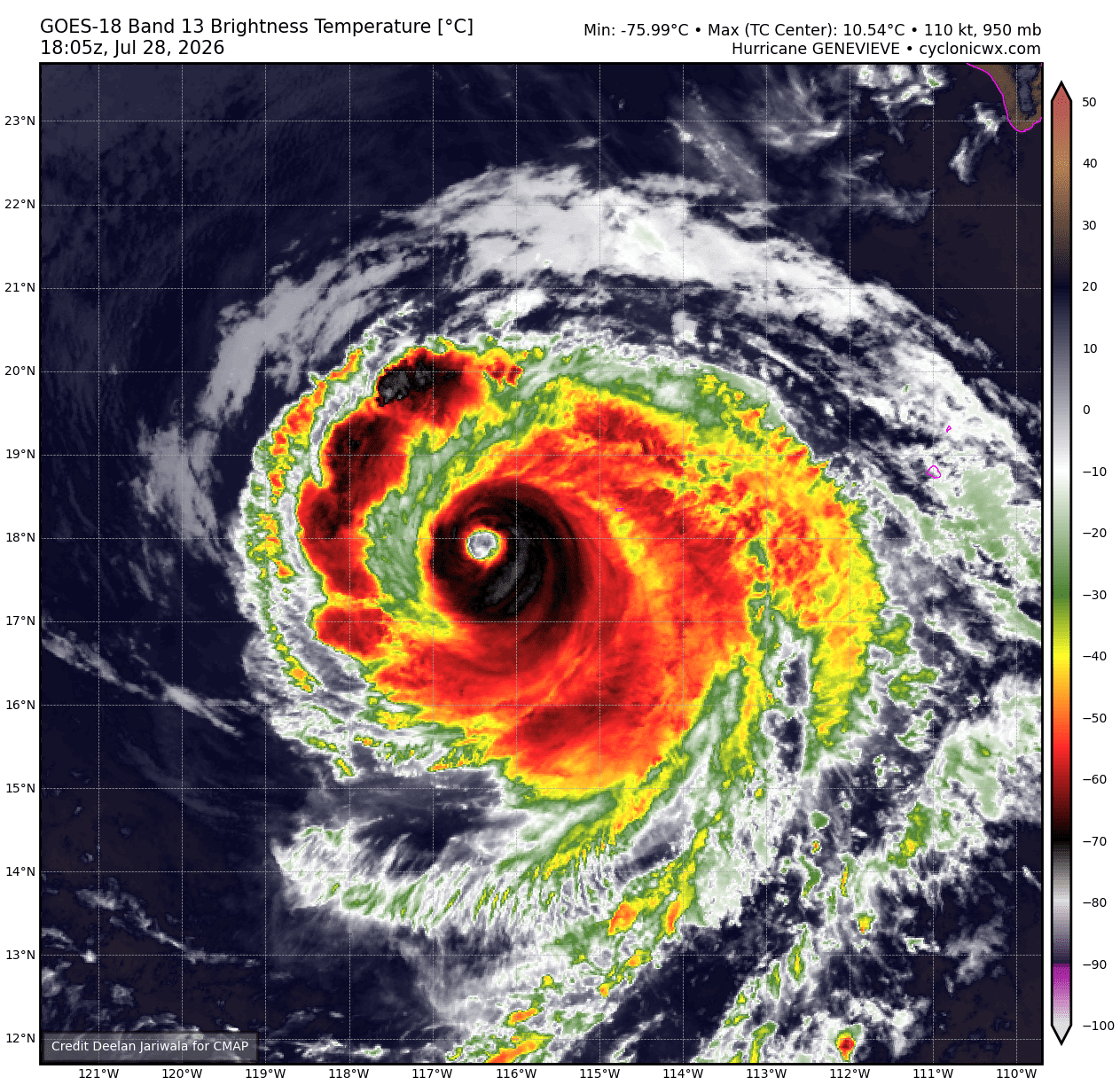
It may seem counterintuitive that a powerful hurricane can amplify a heatwave in California–but that’s exact what’s likely going to happen later this week. Hurricane Genevieve, which rapidly intensified to Category 5 strength amid record or near-record ocean warmth in the eastern tropical Pacific Ocean, will slowly weaken as it “spins down” over much cooler waters on its west-northwestward path. As it does so, however, it will indirectly amplify the Pacific Southwest ridge (to record levels) by serving as a unusual source of atmospheric heat.
How does this work, exactly? Well, strong hurricanes are associated with extremely intense updrafts in tall convective clouds that surround their inner core. These powerful, thunderstorm clouds are associated with continuous, very heavy rainfall–the sustained condensation required to sustain which causes an enormous amount of latent heat release as water vapor turns into liquid. (Hurricanes are, in essence, meteorological “heat engines” that extract latent energy from warm, tropical oceans through evaporation and dissipate it into the atmosphere) That massive latent heat release results in sensible heating–literally an increase in the actual air temperature. The strong updrafts within the storm, in turn, transport that heated air to great atmospheric heights, where it can persist for some time thereafter influence weather patterns hundreds or even thousands of miles downwind.
In this case, it appears that outflow of such particularly “energetic” air on Genevieve’s northern flank will coincide with an already-building ridge across the Pacific Southwest. This boost of extra mid-upper atmospheric energy can directly build the hot airmass itself, when advected downwind by prevailing westerlies, but it can also help reinforce the dynamic ridge pattern as well by contributing a bit of extra anticyclonic (high pressure-like) “spin tendency” (technically anticyclonic potential vorticity advection, for the meteorologists in the room).
Long story short: It does appear, in this case, that the record-breaking 500mb heights anticipated this weekend over the SW US will be at least partially attributable to Genevieve, and it’s also possible that some of the models are slightly underestimating the potential magnitude of this weekend’s ridge (because many coarser-resolution global weather models, in turn, underestimate the underlying latent heat release in such scenarios due to their limited representation of precipitation).
Stronger-than-average Western ridge, plus increasingly warm near-shore ocean, will keep CA warm into Aug (with possible monsoonal moisture incursions at times), with rising CA wildfire risk
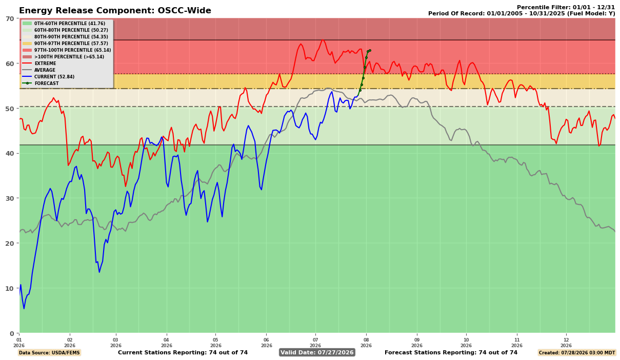
It won’t be extremely hot for two weeks straight across most of the southwest; there will likely be a couple of relative reprieves in there somewhere (the first early next week, and another toward mid-month). But overall, signs continue to point to a prolonged period of hotter-than-the-usual August heat for the foreseeable future. While the most intense afternoon temperatures will be across inland valleys and deserts, coastal warmth (especially in SoCal) will be greatly elevated due to increasingly warm, and possibly record warm, near-shore ocean temperatures. Nighttime temperatures will often to fail to drop below 70F across much of the SoCal metros, and humidity will be extremely high by regional standards. It will be persistently “muggy,” and during briefer periods of elevated heat along the coast and near-coastal valleys, dangerously hot conditions could occur as the combination of unusually high humidity, elevated temperatures, and failure of the natural nighttime “air conditioning” due to the lack of a cool marine layer takes a progressively larger cumulative tool on physiologic resilience. In other words: The pattern predicted several months ago is now coming to pass, and will likely remain for most of the rest of summer and autumn.
This prolonged period of sustained above-average daytime (and nighttime) heat across both northern and southern California will accelerate vegetation curing and drying. In fact, landscape-wide vegetation flammability may approach period-of-record August maxima starting next week–portending a potentially significant uptick in statewide fire activity. In northern California, the interior and northern mountains (which saw very low to record low snowpack this spring despite near-average precipitation) will see a greater risk than the coastal mountains. In southern California, most areas will see a sharp uptick in fire risk and in particular of plume-dominated fires. This is actually a case where rapidly drying fuels, yet a hot and relatively moist boundary layer (thanks to the combination of a strong ridge overhead and very warm near-shore ocean temperatures) could become favorable for some pyroconvection on any major fires that become established. At this time, large-scale strong wind events are not expected in California that would result in extreme fire risk on a widespread basis, but I still expect increased activity and the potential for some more threatening fires as fuels dry and the atmosphere becomes more unstable.
Notably, fire risk across the interior of the Pacific Northwest (from the Cascades crest eastward) into the Northern Rockies will continue to be elevated despite the comparatively mild temperatures. Here, instead, repeated dry frontal passages on the northwestern flank of the big ridge will cause repeated episodes of stronger winds/very dry air–fanning the flames on any existing and new fires in the existing severe drought region (which have already burned over 1.5 million acres in recent days).
During this period, there are some hints that monsoon moisture may once again begin to rotate around the western periphery of the unusually strong SW-centered ridge. That could lead to some mountain/desert thunderstorm activity, increased mid-level clouds and humidity just about everywhere, and (as always) a very slight chance of some thunderstorms closer to the coast. This would be subject to mesoscale details (easterly waves, MCS activity) that’s impossible to predict more than a few days in advance, so stay tuned on that front. But for the moment, it does not appear that any widespread incursions of deep monsoon moisture into California are on the immediate horizon.
Some Weather West updates: Website improvements, a (tentative) move away from ad-supported model, and more!
I have recently made, and will continue to make in the coming months, some changes to this website and my other social communication channels to help ensure the sustainability and accessibility of the Weather West platform moving forward. Most of these changes are “in the background,” and you may not notice them (though hopefully you’ll experience a faster, and slightly less cluttered, experience). But other changes are a bit more consequential–chief among which is the move away from display advertising as a means of offsetting the considerable and growing costs of operation. Weatherwest.com has been around for 20 years now, believe it or not, and the web landscape has changed dramatically over those two decades. My goal, in making this pivot, is to keep Weather West (not only this website, but my entire web presence) as welcoming an environment as possible while ensuring it remains accessible to everyone. I have already removed all advertising from my YouTube livestreams (while live), and am seriously considering removing all ads from this website as well (except, possibly, for some hand-picked ones from specific entities that reach out to me directly). To make this possible, I have expanded the range of options available to support Weather West directly. These now include:
- Recurring support through Weather West directly
- Recurring support via Patreon
- Recurring support via channel membership on YouTube
- One-time and/or recurring support via Buy Me a Coffee
Because I am planning to slowly move away from an ad-supported model, the “ad-free” tier of direct support will no longer be described as such. Instead, I will begin to offer one (decidedly modest, but hopefully desirable!) perk to recurring supporters at all levels and across all platforms: Access to a special, twice annual “Ask Me Anything” livestream on YouTube. These sessions will have a much broader focus than my usual topic-specific sessions (i.e., they won’t be event-driven, and I will instead encourage wide-ranging and tangential questions from the live audience), and is intended to serve primarily as a “thank you” to those who are able to help support Weather West on an ongoing basis.
And to those not able, or inclined, to offer this kind of support–never fear! There will never be any paywall on this website or any of my other channels; all past and future content will remain fully available to everyone, and I’ll continue to have my regular freely-accessible livestream events. Voluntary direct support won’t buy any special access (with the singular exception of those twice annual “thank you” events); it simply helps ensure the continued accessibility of this platform for everyone. Please also remember: Just by reading these posts, watching these livestreams, sharing these pages with others, and engaging in weather and climate-related discussion in your own communities, you are also meaningfully supporting Weather West and the broader mission it represents. So thank you all, once again, for continuing to be here after all these years.
If you’re interested, I’ve offered more details regarding these planned changes and the motivation behind them in this article on Patreon (and, as always, you don’t need to be a member to read it!).
YouTube livestream to discuss heatwave, Hurricane Genevieve, and Northern Hemisphere surge in extreme fire weather
On Wednesday, July 29th at noon Pacific Time, I’ll host a YouTube livestream to discuss the upcoming double-peaked SW US heatwave, its links to Hurricane Genevieve, and also the recent surge in extreme fire weather conditions (and also historic fire activity) across a wide range of geographies and ecosystems (from the Columbia Plateau of the PacNW to the boreal forests of Ontario to the Atlantic coast of France). See you then!
Discover more from Weather West
Subscribe to get the latest posts sent to your email.