As “meteorological summer” draws to a close, a few reflections regarding CA and the broader West
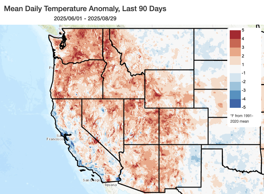
Meteorological summer ends tomorrow (at the end of August), so I thought it would be worth taking a look back the last three months. Now, along the California coast, it’s almost always the case that September (and sometimes October) are warmer than “canonical summer” due to the decrease in near-shore cold water ocean upwelling and coastal low/clouds and fog that dominate the spring and early summer months–and that’s likely to be the case this year, too. In fact, coastal regions in parts of northern and central California are (as I type this post!) currently experiencing some of their warmest temperatures of the year thus far!
It has been a bit of a strange summer across California. July was quite a cool month by the standards of the last 30 years nearly statewide, and both June and August were also pretty cool along the coast (though were much warmer inland and at higher elevations). In fact, in some places in central and northern California, Jul-Aug 2025 will likely end up (despite the present heat, and once the formal numbers are crunched in a few days) among the coolest in the last 30 years! That’s a pretty notable achievement–though it is once again worth re-emphasizing, as I’ve discussed at greater length in recent posts, that is largely due to the long-term shifting baseline in a warming climate. Summer 2025 was indeed notably cool along the California coast relative to the last 30-40 years–“much cooler than the recent climatological average” would be a fair statement. But such a summer would have been fairly ordinary in the first half of the (cooler) 20th century in nearly all such locations.
Meanwhile, across California’s desert and higher foothill/mountain regions, Summer 2025 ended up warmer than even our recent warmer-climate average (despite the cool July). Prolonged elevated heat, including persistently warm nighttime temperatures for long stretches–helped locations above the marine inversion experience a considerably warmer than average summer overall. And in the bigger picture: aside from the California coast, nearly the entire American West did indeed experience, as predicted, a much warmer than average summer (and locally near-record or record warm in some portions of the parched interior Southwest).
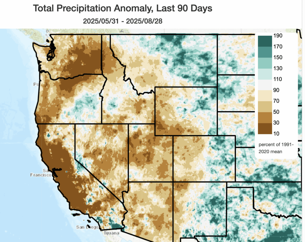
Despite the recent monsoonal surge, it is also been a pretty abysmal summer monsoon across most of the Southwest as well. Recent precipitation has attenuated the monsoon precipitation deficits somewhat, but over the past 3 months conditions have been anomalously dry across most of the West (including the core monsoon region). Near-zero precipitation is normal in coastal California during summer, of course, but the higher mountains and southeastern deserts do usually see some substantive precipitation in July and August in the form of afternoon thunderstorms. These did occur, in some places, but this left a patchwork of (mostly) below but (locally) above average precipitation in California’s mountains and deserts as relatively sparse but occasionally very intense thunderstorm downpours were the rule.
Holiday weekend heat inland (with some wildfire smoke) but brilliant blue and fog-free skies along California coast
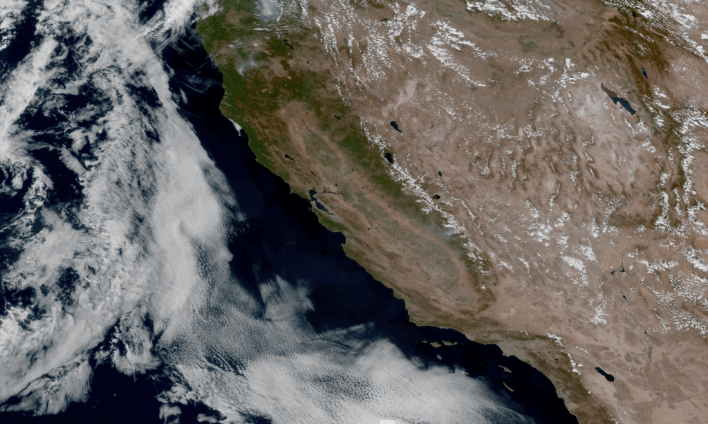
As of this writing on Saturday afternoon, temperatures were substantially warmer than average nearly everywhere in California–including the immediate coastline. In fact, the afternoon satellite imagery indicated a (striking) virtually cloud and fog-free coastline from Oregon to Mexico–indicative of weak offshore flow that has allowed temperatures in some near-coastal regions to warm more than predicted and to their highest levels for the season to date. However, since coastal California has historically seen rather extreme heat aligned with the Labor Day weekend, it’s unlikely that any substantive records will fall as the bar is pretty high this time of year. All in all, this weekend is bring pretty spectacular beach weather and rather hot (but far from record-breaking) warmth inland with mostly clear skies (except for some drift smoke from wildfires up in the Klamath Mountains and southern Sierra Nevada).
Complex omega-to-rex blocking regime to bring very unusual eastern Pacific set-up, including extreme BC/interior PacNW heat & wildfire outbreak potential
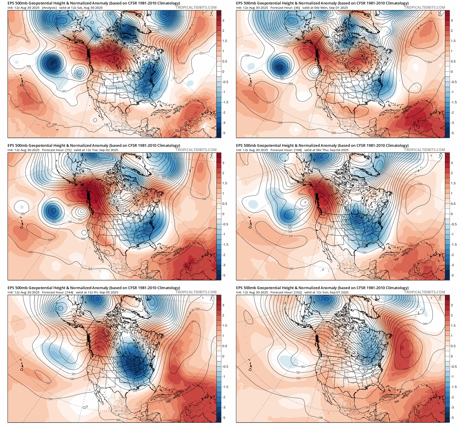
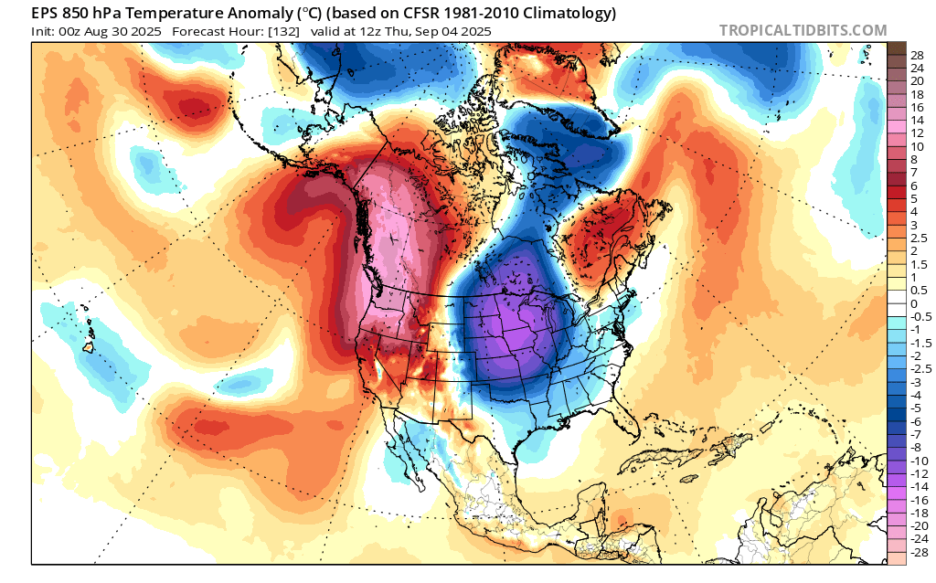
Well, I’ve got to say: the upcoming weather pattern this week across the far northeastern Pacific and west Coast of North America is one of the stranger set-ups I’ve seen in early autumn in quite some time. It will feature a very strong and highly anomalous (likely record-breaking) blocking pattern, centered all the way up in northern British Columbia and Yukon Territories up in Canada, and likely generate some of the hottest September (or perhaps even autumn) temperatures ever observed across much of western Canada and possibly portions of the interior Pacific Northwest (from the Cascades eastward). Accordingly, this will likely be a record-breaking (and possibly even “record-shattering”–meaning it could break all-time records for September or the entire autumn season by a substantial margin) in some areas to the north of California. This overall pattern is actually somewhat reminiscent of, though not quite as extreme as, the astonishing June 2021 heatwave that shattered all-time heat records across a wide region and led to severe societal and ecological impacts. Fortunately, this event is hitting later in the season when days are shorter and the heating potential from a weaker sun angle is less than in June–so peak temperatures will be lower and overnight recoveries might be better.
However, despite some anomalous August rain from an out-of-season atmospheric river, most British Columbia and the Pacific Northwest have been substantially hotter and drier than average for the past few months. So the development of a prolonged and likely record-breaking heatwave there will likely result in the potential for a significant late-season wildfire outbreak. While significant September wildfires are not at all uncommon in California, where peak seasonal heat and the onset of the rainy season tends to be shifted later, they are far more so in the northern Pacific Northwest and western Canada as seasonal rains often begin to arrive there not long after Labor Day. That is doubly true as the process of “ridge breakdown” often leads to substantial wind events–further fanning any fires that might ignite during the very hot and dry period immediately preceding. Additionally, there is the potential for isolated to scattered thunderstorms (especially over the mountains, but possibly elsewhere) across much of the PacNW and BC during this event–possibly catalyzing new fire ignitions in remote areas. In many ways, the most significant impacts from this likely record-breaking ridge and heat event across BC and portions of the interior NW will be wildfire-related. The sequence of “extreme heat to thunderstorms to ridge breakdown (with wind)” is a pattern associated with many substantial wildfire outbreaks in forested regions of the NW US/SW Canada, and that could well play out similarly over the next 7-10 days.
California looks pretty hot next 7-10 days–especially northern interior–but with some possible surprises (including monsoonal and/or tropical moisture incursions)
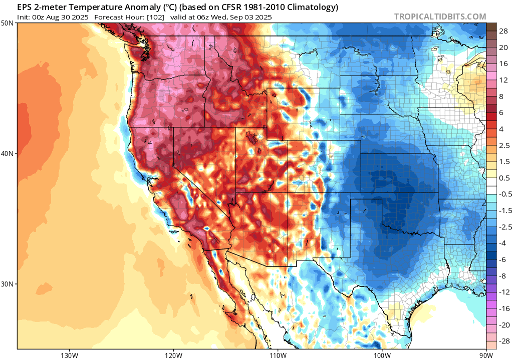
In contrast to the genuinely extreme and record-breaking heat potential in the far NW interior US and British Columbia, California will see substantially elevated but much less extreme heat in the coming days. The base of the ridge axis already extends southward across California and will strengthen further over the next 72 hours, prolonging and intensifying the ongoing heatwave. While I don’t generally expect record-breaking daytime temperatures in California during this event (except possibly across the far northern interior in the NW Mountain/Shasta region, where some notable lightning ignited wildfires are currently burning), nighttime temperatures may be notably warm (including along the coast, where ocean surface temperatures are now notably warmer than average along the entire coastline (see below)). Elevated, but not extreme, fire weather conditions are expected this week across most of California–likely allowing for increased activity and spread on existing fires. Except for localized sea/mountain breezes, no strong large-scale winds are expected–which will prevent fire risk from being higher.
For those looking east: this extreme blocking pattern will also bring notably anomalously cool temperatures to the Central U.S. this week as part of the broader “dipole”–but as has often been the case for similar high-amplitude flow events in a warming climate, the number and magnitude of high temperature records in the Pacific Northwest/western Canada will greatly exceed the number/magnitude of record low temperatures in the Central U.S. (notable though they will still be) for the very same event.
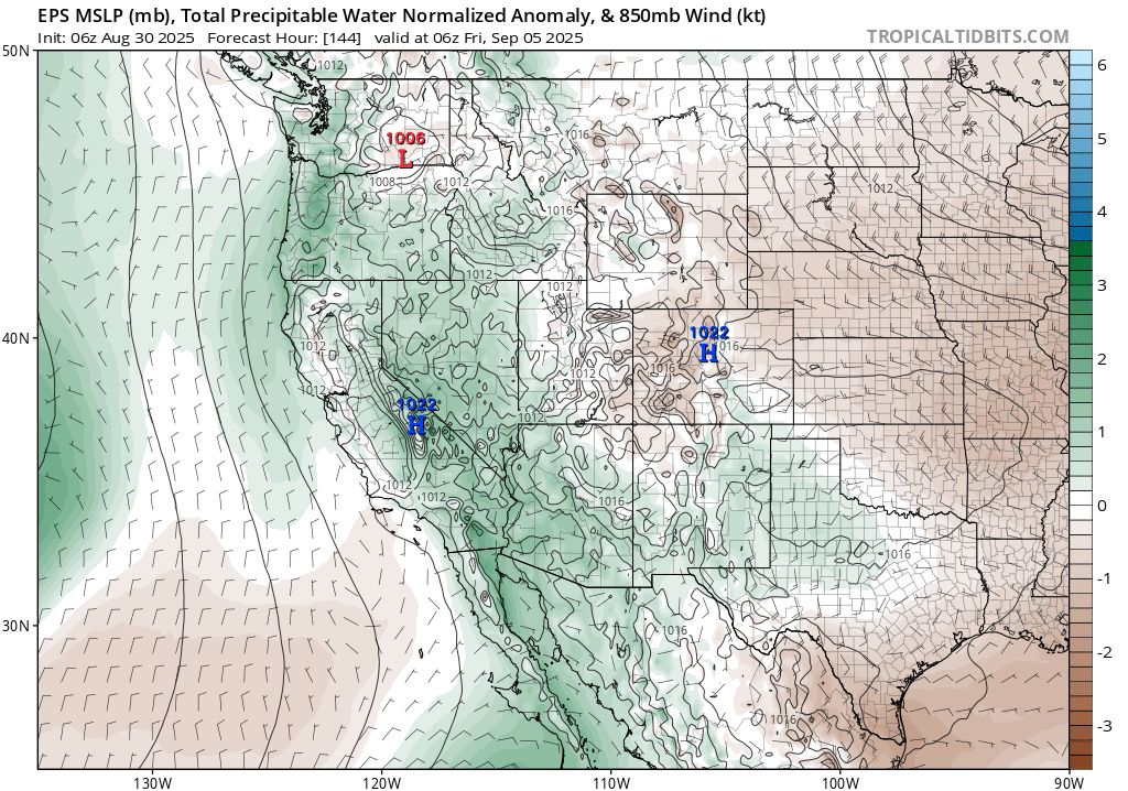
There are a couple of wildcards, however, that may come into play 4-7+ days from now. The first are the two low pressure systems interacting with the record-breaking blocking pattern over the Pacific Northwest/Canada. These will initially become locked “under” the ridge in the form of an “omega block” that will eventually transition toward a more “rex blocking”-type feature–characterized by a strong and persistent ridge with a low pressure system immediately equatorward (to the south). These swirling lows will have slightly erratic trajectories–mostly staying offshore of the West Coast, but making one or two close passes before retrograding offshore again over the next 10 days.
In the meantime, there will be both a “traditional” late monsoonal moisture surge (weaker than last week’s) and also possibly some residual tropical/subtropical moisture offshore from the remnants of a soon-to-be East Pacific tropical system. The monsoonal moisture may bring some isolated/scattered thunderstorms to the central/southern Sierra and SoCal mtn/desert regions later this week, but there is a slight chance that there could be some more widespread (and, yes, possibly dry) thunderstorm activity elsewhere in the state if the offshore low can exert enough forcing near the coast and/or of the tropical/subtropical moisture can become entrained. (A similar situation, with slightly higher likelihood, could play out in OR/WA/BC). The main risk here would be the potential for lightning-ignited wildfires amid unusually warm/hot conditions. Though the risk in California looks low for now, it’s something worth keeping an eye on for now as this is a tricky/complex pattern to model and there is at least some hint of the disparate ingredients needed for “surprises” during such an unusual set-up. I’ll discuss this more in the coming days during on YouTube and elsewhere on social media.
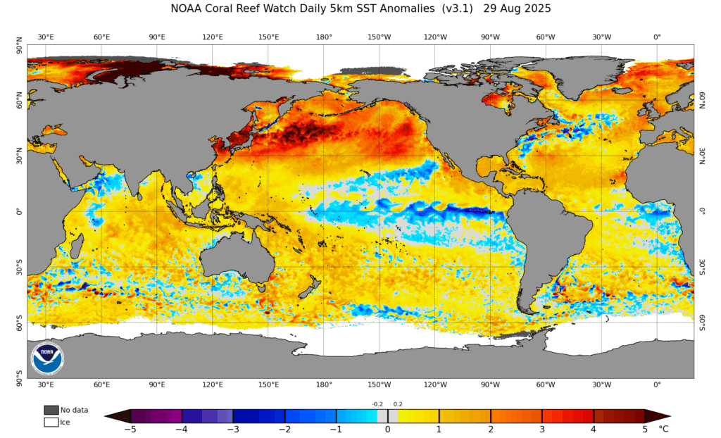
Finally, as noted earlier, near-shore ocean temperatures have finally (and later than expected, though pretty definitively) warmed to notably above-average levels along the entire California coastline as of the weekend. In fact, near-shore SSTs are now above average along the entire Pacific Rim coastline from near Panama to China! The entire North Pacific, as a whole, is now experiencing a still-expanding and already extreme marine heatwave that is breaking all-time records in some areas. I’ll talk a bit more about this in subsequent blog posts and YouTube sessions, but I will say this: such an extremely large region of highly anomalous warm water can have multiple, and sometimes counterintuitive/conflicting effects, on the Pacific storm track and the intensity of autumn/winter storms (as it can add a lot of additional moisture to the atmosphere through increased evaporation–but also disrupt, shift, and weaken the jet stream). More to come, but for now–enjoy the weather this weekend!
Special holiday YouTube livestream to discuss unusual East Pacific pattern, extreme BC heatwave/wildfire threat, and California implications
Join me live at 10am Pacific Time on Monday 9/1!
Please consider completing a short and anonymous survey regarding my weather & climate communication!
As part of my (relatively!) new University of California Agriculture and Natural Resources role, I’m currently collecting basic demographic information (as well as a few other details) from folks who have engaged with my various web, media, and in-person weather & climate communication activities. If you have a moment, please consider filling out this survey (which will probably take most folks 5 minutes or less to complete). Collecting these details will help me and UC ANR ensure that we’re reaching a broad audience that is demographically representative of Californians in all corners of the state. Thanks, as always, for your ongoing engagement and support!
Click here for a direct link to the survey!
Discover more from Weather West
Subscribe to get the latest posts sent to your email.