A remarkably cool start to summer in coastal northern and central California–but unusually hot inland and in mountains!
It has been a very cool start to the summer (from May through mid-July) across the entire coastline of northern and central California, as well as much of the San Francisco/Monterey Bay Areas in general as well as the southern Sacramento and northern San Joaquin Valleys exposed to cooler marine air via the Carquinez Strait. In fact, in some specific locations, the May-mid July 2025 period has been among the coldest in the past 30-40 years (meaning, for some younger folks in the Bay Area, this might be the coolest start to any summer in their living memory). It has been chilly, unusually windy, and often cloudy under a very persistent marine layer in these regions.
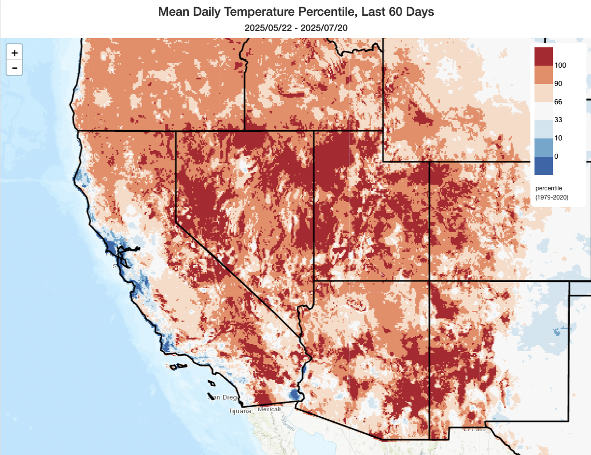
However, well inland and at upper elevations, conditions could not have been more different: days and nights have both been much warmer than average in these areas since May, and a few spots have even approached or tied all-time record high temperatures for this very same period during which the coast has been so chilly that it’s been (literally) newsworthy.
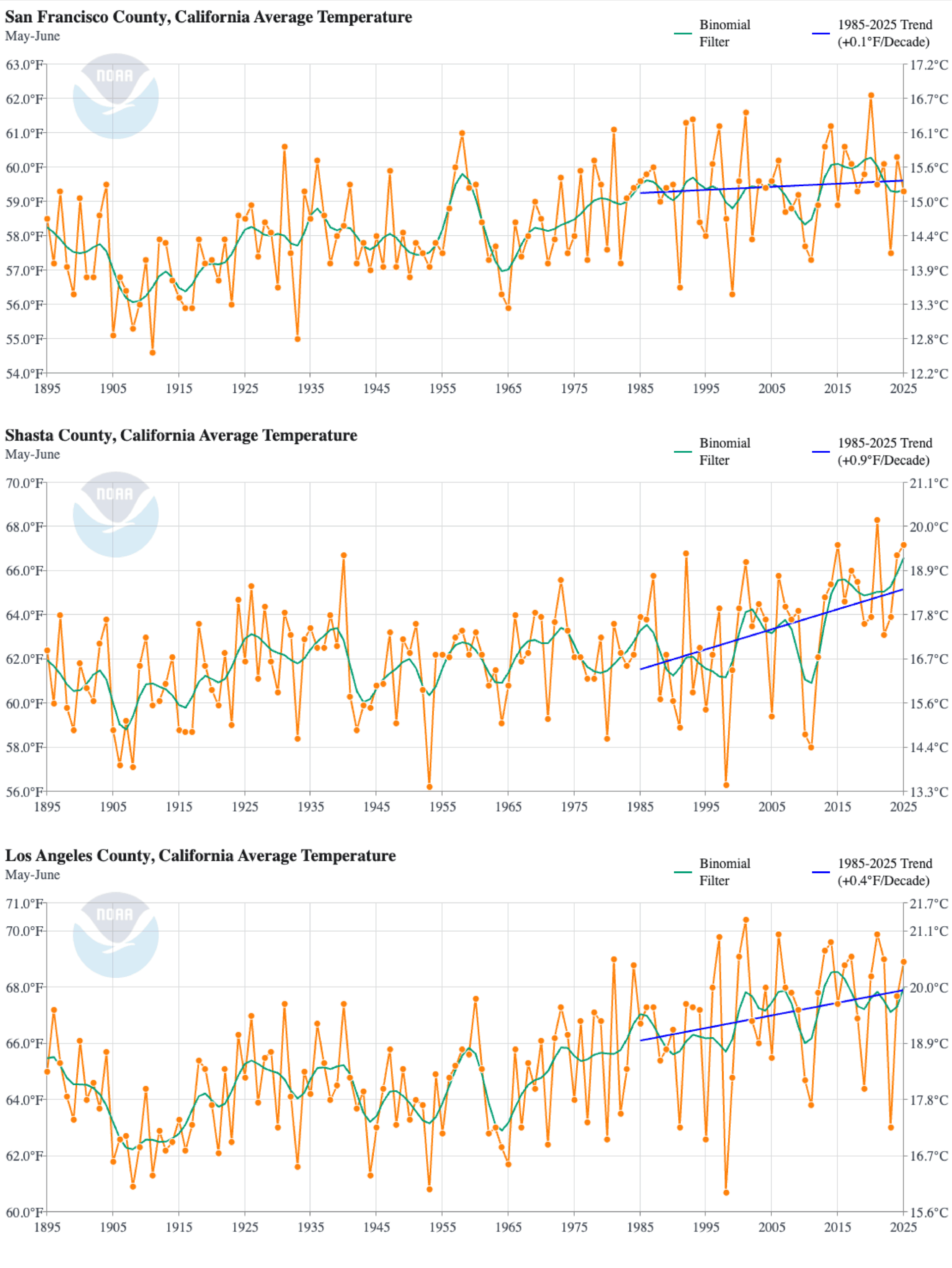
It’s worth noting that even in San Francisco–the California city where the summer-thus-far chill has been most pronounced, temperatures in May-June 2025 would have been quite unremarkable in the early 20th century. It’s only in the context of the last 30-40 years that a start to summer as cool as this one is especially notable–another indication of our “shifting baseline syndrome.” Also notable is the relative lack of warming in the late spring/early summer months along the northern and central California coast compared both to inland counterparts (where May-June warming over the last 40 years has been dramatic) and even these very same locations at other times of year (where warming has been far more rapid than during May-June, months during which average temperatures have been rather flat in recent decades in places like SF).
Anomalous surface high pressure has been driving cold ocean upwelling; California now stands out singularly in global context
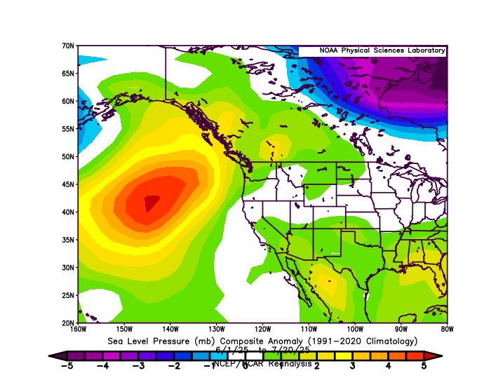
Since May, a region of anomalous mid-atmospheric ridging has persisted across the far northeastern Pacific. But perhaps more relevant to this story is the persistent area of surface high pressure, centered a bit farther to the west of California, that has driven weeks on end of anomalous northerly and northwesterly surface winds along and west of the northern/central California coastline. These persistent coast-parallel winds have generated unusually robust oceanic upwelling–upward vertical movement of cold ocean waters from the deep–just offshore of the SF Bay Area and adjacent portions of North/Central Coast. (For those wondering how this works, physically, or why future projections suggest an increase in early season upwelling (through May-June) and a decrease in late season upwelling (July onward), check out this paper.)
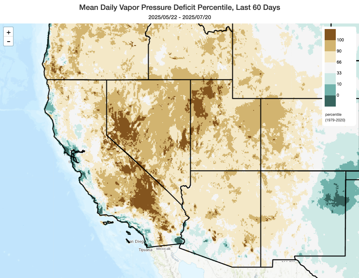
Overall, persistent ridging has actually been the dominant paradigm since May across the northeastern Pacific and across the West. But that pesky surface high, in just the right location offshore, has kept near-coastal regions in northern and central California really cool thanks to that increased upwelling–among the coolest May-June periods, in some locations, in the past 40 years! Yet just 50-100 miles inland, the influence of anomalous ridging has dominated. In fact, May-June were (yet again) among the top 3 hottest on record across much (even most) of the Great Basin, southern and central Rockies, and even portions of mountain and interior California. So the contrast this summer so far has been quite extreme, from “among coldest in 40 years” along the immediate NorCal coast to “among the hottest, if not the hottest, in over 100 years” across some of California’s interior mountains. This has resulted in a summer that has been anomalously moist along and near the coast (with lower than average evaporative demand) and anomalously dry far inland and in the mountains (with very high evaporative demand and VPD).
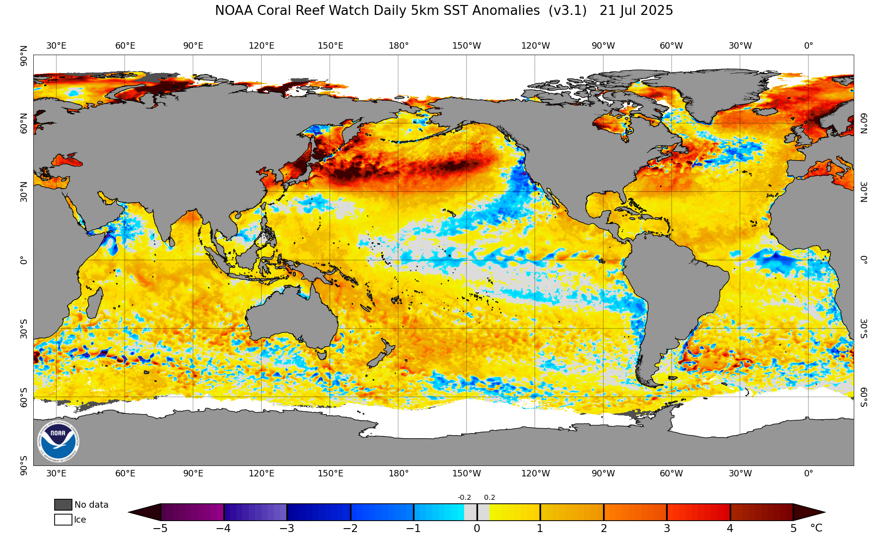
Notably, the cool patch of ocean water immediately offshore of northern California is now, by a wide margin, the most anomalously cool patch of ocean anywhere on Earth at the moment. The North Pacific waters, generally and under the offshore ridge, is exceptionally warm (generally 3-5F and locally as much as 9-10F above average, which is enormous for an ocean basin!). Similarly, the North Atlantic and especially Baltic and Mediterranean Seas have been experiencing exceptional to record-breaking warmth (with record-breaking terrestrial heatwaves in regions upwind of these warm ocean zones). At present, California is lucking out. And if you you want to hear more about my perspective on why that might be, and what the future may hold in this regard, tune into my YouTube session later this afternoon.
Cool weather pervades all of California this week, with some mountain thunderstorms; heat and ridging will probably return Aug
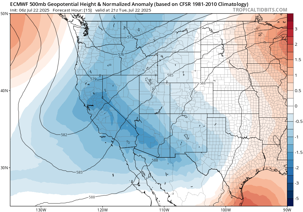
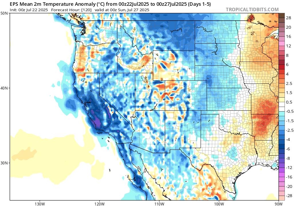
Believe it or not, anomalous coolness will actually be even more widespread this week than it has been almost all summer so far. The coast will continue to be rather chilly, but for much of this week even inland and mountain areas will clock in at below average temperatures most days and most night. This will be thanks to (you guessed it!) another unusually deep trough for mid-July in California. This won’t be associated with any kind of dramatic frontal passage (in fact, that already happened yesterday and was associated with a narrow band of mid and upper-level clouds that brought mostly virga but a few sprinkles/light showers did reach the ground in parts of NorCal), though some coastal drizzle will be possible as well as isolated to scattered showers in the Sierra Nevada and northern mountains. In fact, some dry lightning strikes are possible up north with a handful of additional new wildfire starts possible where conditions have been anomalous warm and dry recently (which is, indeed, across most of the CA interior), aided by relatively dry air and gusty winds during this period. But no extreme fire weather risk is expected, and temperatures will be below average during this period even across the far interior regions.
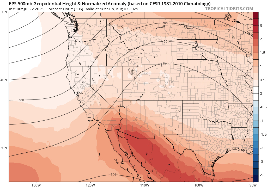
Looking ahead to early August–now only a little over a week away, believe it or not–it does appear that model ensembles are suggesting a relatively high likelihood that the western flank of a (seasonably) strong Four Corners ridge will become (unseasonably) intense over CA/AZ/West Coast. This is a pattern that has been depicted multiple times this summer, but has only actually materialized a couple of times and generally in somewhat muted form. Will this time be different? Well, obviously, I cannot guarantee outcomes (much I’d like to be able to). But I still expect precisely this pattern to, eventually and finally, emerge later this summer and bring much more widespread anomalous heat to CA. It has already done so across the Great Basin and the Western interior, but coastal California keeps missing these heatwaves.
As coastal upwelling seasonally diminishes starting in late July or early August, it becomes easier for such patterns to manifest and bring hot weather all the way to the coast. As the marine layer fades and upwelling diminishes, strong ridges inland have an easier time generating coastal CA heatwaves beginning around mid-August and continuing through September (or, in some years, October). That’s the main reason, BTW, why the hottest temperatures of the year almost always occur in late summer of autumn along the northern and central California coast.
This year may end up featuring a super-charged version of that usual progression from cool/foggy coastal weather in spring and early summer (perhaps through mid-summer this year) and much hotter/clearer conditions from August into Sep/Oct. Seasonal models still depict anomalous warmth all the way to the coast and even offshore by Aug-Oct, though it’s also true that such models still lack the spatial resolution to fully resolve the CA coastline and associated near-shore upwelling effects (though, again, this almost always fades away from Aug-Oct). There is still, therefore, a notably strong heat signal for the rest of summer and autumn across CA and the broader West (especially inland, but also progressively closer to the coast later in the season). That means that wildfire season may yet become a major story a month or so from now across much/most of California; I’ll discuss that more in my YouTube session later today and in future blog posts. But for now, enjoy this remarkably mild mid-summer week in California!
Live YouTube office hour Tuesday, July 22 at 3pm Pacific Time!
I’ll discuss, in greater detail, the remarkably cool start to summer in coastal NorCal and offer some broader context, as well as discuss the rest of summer and the ongoing Western U.S. fire season.
New installment of Climate Extremes: Extreme Weather now available!
The second installment in the Climate Extremes documentary series is now available on YouTube! This one is focused specifically on how long-term warming is increasing the severity and frequency of many types of extreme weather events globally, including what this means for societies and ecosystems and our ability to manage increasing risks in a warming world. I appear extensively in this film, and also acted as scientific and technical advisor to the production team (as was also the case in the film’s first installment, released last fall). Please feel free to watch and share–it’s freely available to all via the link below!
Discover more from Weather West
Subscribe to get the latest posts sent to your email.