A record-breaking north-south precipitation contrast conditions in CA amid warmer-than-average conditions
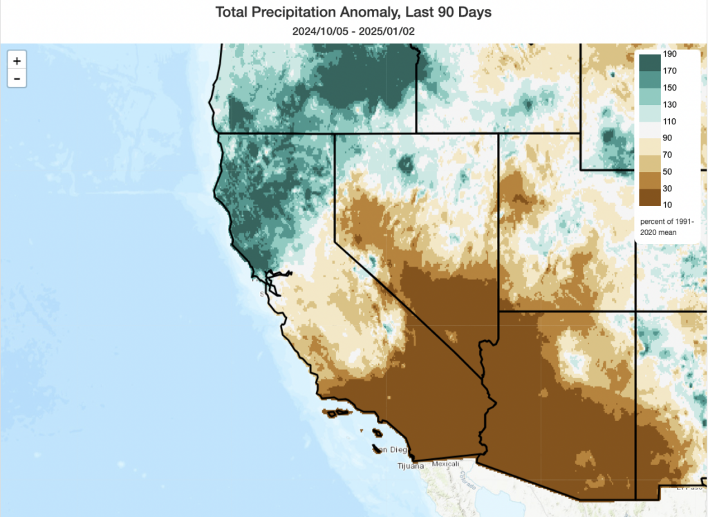
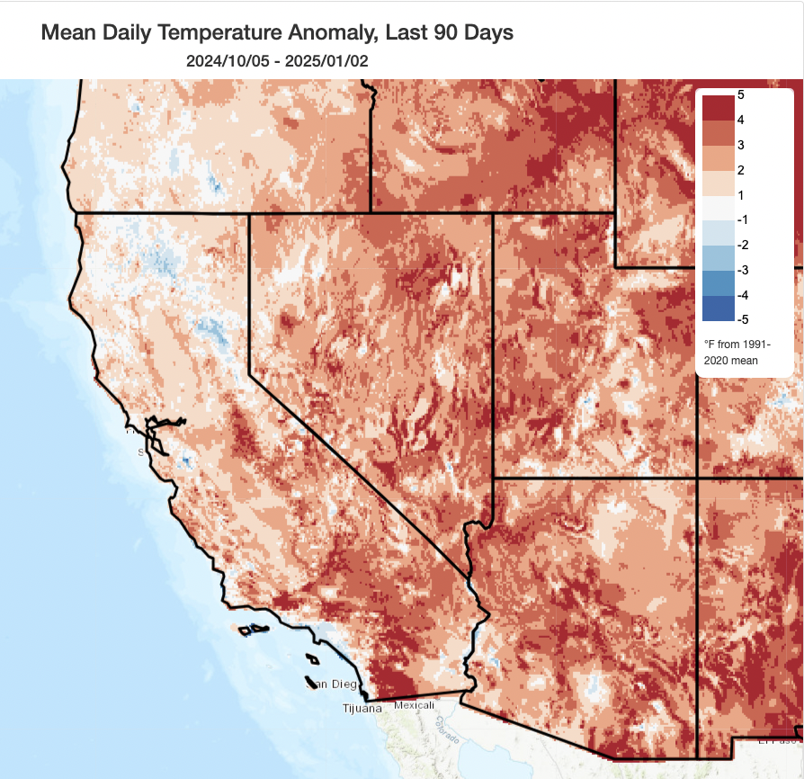
Heading into the new year, from mid-December, it appeared likely that the already extreme precipitation disparity between very wet northern California and bone dry southern California would continue. And…it certainly did, with rather frequent soakings continuing north of the Interstate 80 corridor (which has remained an almost bizarrely sharp dividing line!), occasional rains as far south as the northern Central Coast, and near zero precipitation south of that point. These have been relatively warm storms, too, maintaining overall warmer than average temperatures across nearly all of California in recent weeks (except the far northern mountains and, interestingly, a narrow swath of highly-populated coastal SoCal, which has actually been relatively cool and foggy with poor air quality under a stagnant and subsident airmass).
The remarkable “precipitation dipole” across California has, at this point in early January, now reached essentially historic proportions. Portions of San Diego County have seen their driest start to the season (and 9-month period overall) in over 150 years; the contrast between (anomalously wet) NorCal and (record dry) SoCal is even more anomalous than either the northern wet or southern dry anomalies on their own. It is truly a matter of the precipitation “haves” and “have nots” at the moment–and there is no real prospect for this to change in the short term; even in the long term, it remains possible this overall dipole persists for the rest of the season (though hopefully with less extreme intensity).
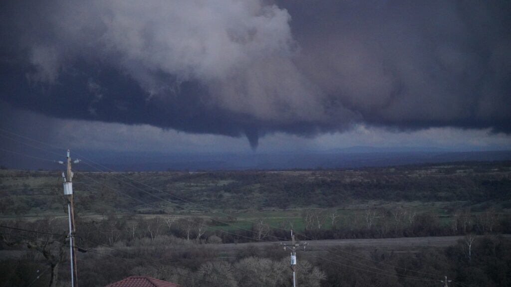
In northern California, and across portions of the Pacific Northwest, many of this season’s storms have been notably convectively active, with lots of thunderstorm activity and (occasionally severe) convective wind gusts. In several instances, unstable airmasses have overlapped with terrain-driven wind convergence to generate notable tornadoes–most prominently back in December in Santa Cruz County and now just yesterday near the Tehama/Shasta county line. (I suspect this likely has to do, at least in part, with unusually warm ocean surface temperatures over which recent West Coast winter storms have traversed–which can increase low-level atmospheric buoyancy and subsequent instability.) Thanks to Craig Heden for sharing the striking photo of this tornado below, which achieved an “EF-U” (unknown intensity) rating from the National Weather Service. Tornado intensity is estimated on a purely damage-based scale, and in this case there was no damage reported as the storm occurred in a rural area (meaning there were no specific indicators of intensity, despite the obvious occurrence of a tornado based on radar data, and video/photographic documentation).
Major, prolonged, and possibly extreme offshore wind and fire weather event to unfold this week across SoCal
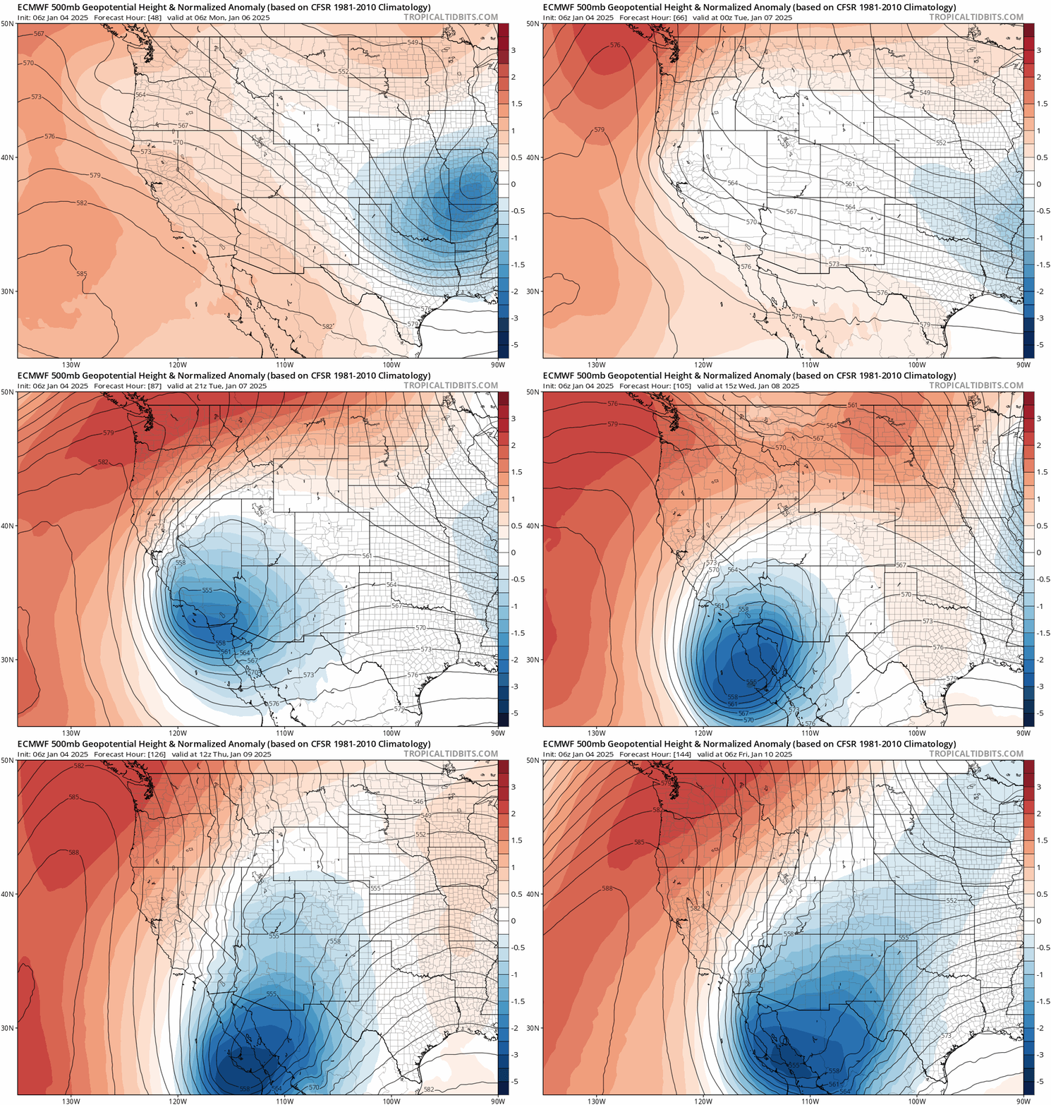
A pattern change of sorts appears imminent–but not the one most folks in SoCal were hoping for. Instead of a continuation of a very strong wet north/dry south precipitation dipole, the entire state will be mostly dry for the next 7-10 days. But this will not be a quiescent continuation of the dry spell in SoCal–far from it. Instead, a quite unusual weather set-up will facilitate a long-duration, moderate-to-strong intensity offshore wind and fire weather event this week across a broad swath of Southern California. This event will not only be especially prolonged and intense, but will likely also occur over a more widespread area than usually sees strong winds during Santa Ana events–including many lower elevation locations (lower foothills and even valley) where locally damaging wind gusts and serious fire weather risk will exist. There is a (modest but nontrivial) chance of an even more extreme downslope wind event, possibly featuring localized mountain wave activity, that could produce smaller swaths of highly damaging wind gusts and extremely critical fire weather risk, but even the median scenario at this point will feature widespread strong winds and very high fire risk. I’ll discuss the details below.
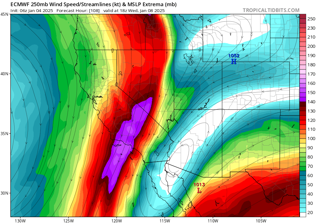
The overall pattern is a fairly unusual one: a retrograding (in this case, southwestward-moving) low pressure system will move across SoCal later this week, setting up shop for several days in a position that will favor a multi-day (3-5 day!) offshore wind event. Due to strong upper-level cold advection and very robust upper jet support (a NE-SW (!)-oriented 150kt jet streak!), winds may be both stronger and more widespread than somewhat unimpressive surface pressure gradients might otherwise suggest. Indeed, many areas that are typically somewhat wind-sheltered during classic Santa Ana events will be exposed to strong gusty and possibly even damaging winds with this one–so the risk of power outages and tree damage will be pretty high (and I also suspect there will likely be pre-emptive “public safety” outages in some regions, as well).
The exact location and magnitude of the strongest winds will depend on mesoscale details of this complex and rare low pressure system trajectory, so it’s still a bit too early to discern the details. But right now, it’s clear there is very high confidence in at least a moderate to strong downslope wind event and fire weather event across much of SoCal later this week that will be fairly long in duration. There is at least a slight (10-30%) chance of an even stronger wind event, which could feature widespread damaging winds extending even into valley areas, caused by the development of mountain waves on the lee side (in this case, highly populated western side) of the SoCal mountains. If that happens, I would expect maximum mountaintop wind gusts of 90-100+ mph in the most exposed areas and widespread gusts to 60-80+ mph elsewhere. The most likely outcome is somewhat weaker but still quite strong and relatively widespread strong winds; I would advise following your local NWS office for more specific details (though I will also be following on social media, including during live YouTube sessions, as the event unfolds).
As is evident from the wind gust graphic below, there will likely be two waves of maximum winds separated by a 12-18 hour period of weaker winds in between. The first wave of winds will likely be the warmest, and perhaps strongest; the second wave, even if somewhat weaker, will likely be characterized by much lower relative humidity and drier fuels (due to the cumulative drying effect “atmospheric blowdryer”-like conditions over multiple days). So the wildfire risk will likely remain extremely high even during the second half of the event, despite slight cooling and perhaps slightly weaker winds. Overall, though, this will be a long-duration event–and in some areas, there will likely be little discernible break between the first and second waves of strong/potentially damaging offshore/downslope winds.
Due to the retrograding (“against mean flow-moving,” i.e. westward-moving) upper low, there is a slight chance of some isolated showers over the highest elevations/eastern slopes of the Transverse Ranges and the mountains of San Diego County during this event if the westernmost model ensemble solutions come to pass. But that remains unlikely, and even if they occur will be very unlikely to mitigate the extreme fire risk elsewhere (as the strongest winds/highest temperatures/driest vegetation will be almost entirely non-overlapping with the region with slight shower chances). In fact, if a few isolated showers to develop over the mountain peaks amid such a high-end downslope wind set-up, that might even increase the risk of localized very strong wind gusts associated with mountain rotors/mountain waves downwind as evaporative cooling and downdrafts from dissipating showers add downward momentum and drag very strong winds aloft closer to the surface.
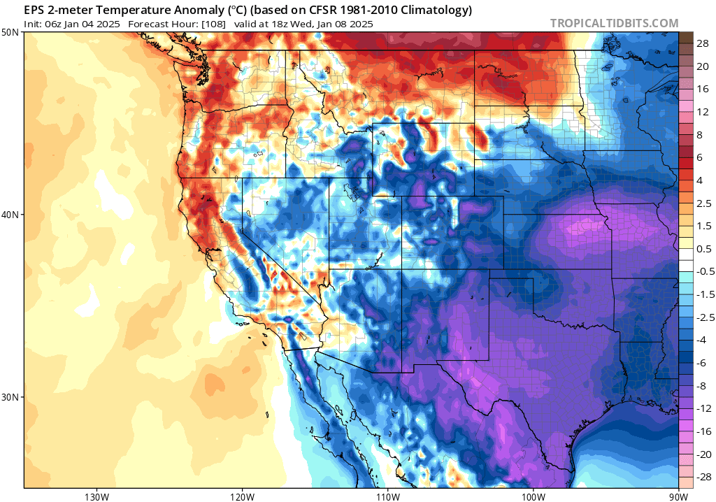
This will very likely be the strongest Santa Ana (or general offshore) wind event of the 2024-2025 season in SoCal, and possibly stronger than anything seen in some years in certain areas (depending on how, exactly, the details evolve; there is still some uncertainty). This high-end offshore wind event is unfortunately coinciding, as previously noted, with a near-record or record dry start to the “rainy season” in Southern California. This means that vegetation moisture in both living and dead plants is already lower than usual, and will plummet further later this week as 3-5 days of moderate to strong offshore flow and very low humidity persists. By Wednesday or Thursday, energy release components/burning index (ERC/BI) values may approach record levels for the early January calendar date. The NWS SPC has already highlighted a broad region of potentially critical to “extremely critical” wildfire risk in SoCal later this week (unusual at this relatively long lead time), and I think it is likely that that the NWS in Oxnard (Los Angeles) will likely issue an elevated/”Particularly Dangerous Situation” Red Flag Warning later this week for at least some areas. High Wind Warnings and Fire Weather Watches are, indeed, already in effect. Fire weather risk of this magnitude will likely entail area/park closures, street parking restrictions, and other pre-emptive actions to reduce the risk of unwanted ignitions and facilitate rapid ingress/egress from high-risk areas if fires develop later this week. This is certainly an event to take seriously if you live in a potentially fire-prone region in SoCal, even in areas that are often sheltered from the strongest offshore winds during typical events.
Thus, the wildfire risk across much of SoCal will be even greater than the sum of its parts (i.e., the strong winds or dry fuels individually). This is an increasingly prominent concern, as has been previously discussed, with increasing overlap between “offshore wind season” and “critically dry vegetation season” in California–and is something that is expected to happen more often with climate change (especially in Southern California).
It is worth noting that there will likely be some gusty northerly winds and low relative humidity across more northern portions of California this week. But due to (very) wet antecedent conditions, the risk of wildfires up north will be negligible to zero (it’s just too damp!). There will, perhaps, be some modestly increased risk along drier portions of the Central Coast and perhaps far southern Sierra, but the big fire weather concern with this mid-winter event is definitely focused squarely on Southern California (from about Ventura/Santa Barbara counties southward).
Multiple live YouTube livestreams this week…stay tuned!
On Monday at 3pm Pacific Time, I’ll discuss a range of topics, focusing on the major-to-extreme offshore wind and fire weather event in SoCal this week, but also touch on the CA precipitation dipole, recent CA tornado activity, and the increasingly pervasive (and demonstrably false) conspiracy theories surrounding…fog in America.
I will likely have at least one additional livestream later in the week to discuss a major scientific paper release on “Global hydroclimate volatility on a warming Earth.” I’ll also likely have another livestream at some point to discuss the by that point ongoing extreme wind/fire weather event in SoCal, depending on how it evolves. Please stay tuned for exact dates/times, which remain TBD at the moment. Consider subscribing to the @WeatherWest Youtube channel and turning on notifications so you don’t miss them!
An announcement regarding my new role as a weather/climate scientist-communicator in California!
I do have some exiting news to announce: I have officially joined University of California Agriculture and Natural Resources (UC ANR)! In this new role, I will continue to engage in weather and climate change research, but with also have a more explicit mandate to continue and expand my longstanding scientist-communicator role. In addition, I will continue my concurrent roles as a climate scientist within UCLA Institute of Environment and Sustainability (IoES) and as a research fellow at the NSF National Center for Atmospheric Research (NSF NCAR), and I will also continue to work with numerous external partners in the public and private sector.
I’m deeply grateful to the many folks within (and beyond) UC ANR for their support and advocacy on my behalf in carving out a decidedly unusual climate scientist-communicator role. I’m also thankful for the Tilia Fund‘s proactive and substantial contribution to this effort. This new role and multi-year support will allow me to maintain a highly visible public presence–so you’ll continue to see me on social and traditional media (and elsewhere). And ultimately, my goal is to help make a similar path more realistic for others to follow for experts and practitioners in the weather/climate change space and beyond!
Discover more from Weather West
Subscribe to get the latest posts sent to your email.