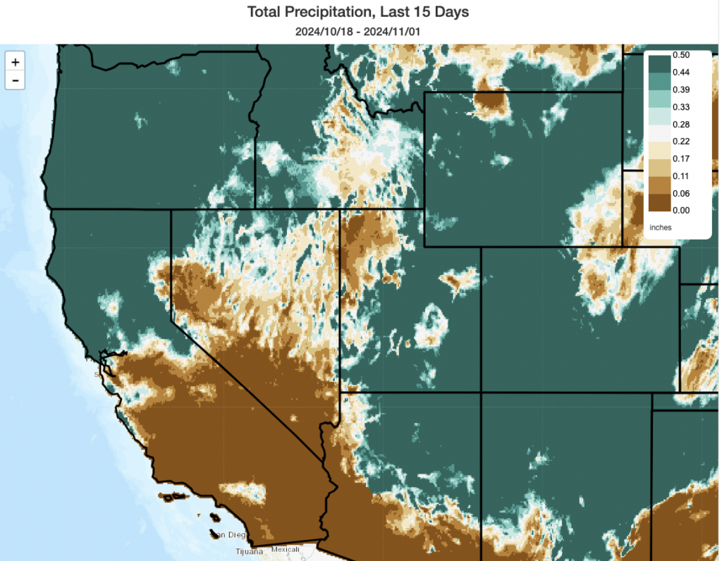
NorCal has seen widespread wetting rain in the past two weeks, but central and southern CA have not

Fortunately, recent conditions in California have not been (quite) as warm or dry as initially suggested by model ensembles (and as noted in the previous blog post) for late Oct and early Nov. Widespread wetting rainfall has now fallen across most or all of northern California, including the SF North Bay region and most other places north of the Interstate 80 corridor. (In the map above, all areas in dark blue-green have seen at least a half inch of precipitation over the past 2 weeks.) Farther south than that, some precipitation has fallen during this period thought it has generally been lighter and patchier–with some places in SoCal and along the Central Coast still having seen little or no rainfall so far this autumn. And temperatures, while they have been somewhat warmer than average in SoCal during this period, have not been nearly as anomalously warm as they could have been during this period.
Mostly dry this week with two offshore wind events (2nd one much stronger?)

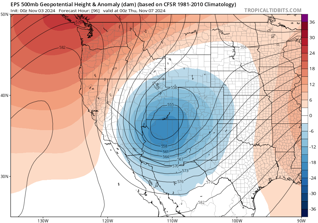
Unfortunately, if you haven’t seen significant rain recently in California, you are also fairly unlikely to see it moving forward for the next 10-14 days. This week, a dry and windy pattern will develop statewide as a pair of “inside slider” low pressure systems dive south and southeastward inland of the California coast and over the Great Basin. In the wake of the passage of these lows, cooler surface temperatures in Nevada will generate surface high pressure there–establishing strong lower-atmospheric pressure gradients and leading to a classic Santa Ana wind setup over Southern California.
There will be two such systems this week: the first Sun-Mon, and the other Wed-Thu. Right now, the second one appears to have higher potential to bring a moderate to strong Santa Ana event to SoCal (with widespread strong and gusty winds extending even well offshore and to the Catalina Islands). It also appears that the second event will have a stronger “offshore” component to wind direction than the first, and therefore will have a more profound land surface/vegetation drying effect versus the more northerly winds from the first event.
Generally speaking, temperatures this week will be near average across California except for cooler than average temperatures in the Sierra eastward as well as in the mountain/deserts of SoCal (so event #2 will be a fairly “cold Santa Ana”).
Despite wind and dry air, relatively low fire risk in NorCal due to recent moisture–but quite high fire risk conditions possible in SoCal

Due to recent precipitation across most of Northern California, wildfire risk is low during this first low RH/wind event and will likely stay below extreme levels during the second event as well from about the SF Bay Area northward (though with some caveats). This is the benefit of early season precipitation: even though most places in NorCal are actually running behind the seasonal-to-date average for Sep-early Nov (a decidedly noisy statistic!), places that have seen half an inch or more of rain recently will be in pretty good shape. Given that there has not yet been a seasonal green-up yet in most places and conditions will still be quite windy with low humidity for an extended period this week, there may still be some fires (especially in grassland settings) up north–but the likelihood of something big or concerning is fairly low up north (event compared to the mid-Oct event). With no further precipitation expected this week, however, and with the cumulative drying effect of several days of windy/low RH conditions expected to be substantial, it’s still a good idea to prevent errant sparks from igniting unplanned/unwanted fires during this period.
Farther to the south, though, it’s a different story. Despite some recent light precipitation across portions of SoCal, the region has generally seen much less than NorCal counterparts in recent weeks. And here the winds this week will be stronger, relative humidity lower, and duration will be longer. Vegetation is starting off drier already in SoCal and will experience rapid further desiccation this week during these two episodes of strong/drying Santa Ana winds. Because the second wind event looks stronger than the first, and because vegetation will become cumulatively drier as the week progresses, wildfire risk in SoCal looks quite high during this second event especially and it’s likely widespread Red Flag Warnings will be raised given the potential for 70-80+ mph wind gusts along ridges and 40-60mph gusts elsewhere during this period as fuel moistures plummet. Fire season is greatly attenuated or over in far NorCal–but we’re now in the peak of “offshore wind-driven fire season” in SoCal and this is going to be one of those high risk weeks.
Ensembles show very “inside slidery” pattern for foreseeable future

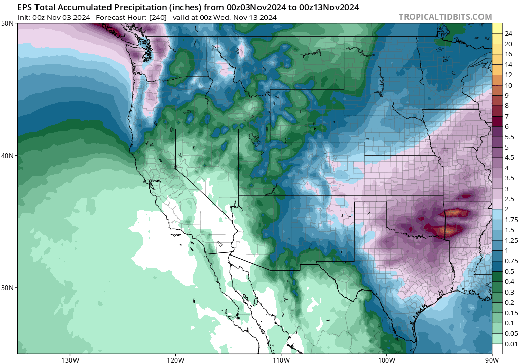
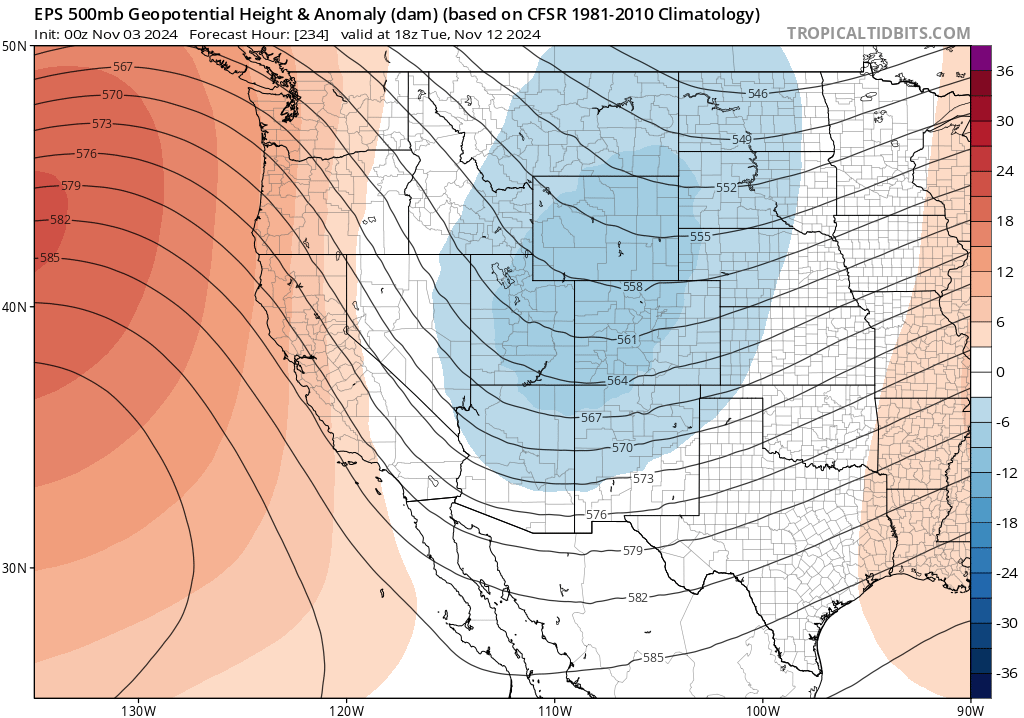
Right now, it looks like the sequence of “inside slider” systems will keep on going for the foreseeable future. The ECMWF and GFS ensembles both have a pretty classic “inside slider” signature present on a repeated basis going into mid-Nov. But there are some differences: the GFS ensemble suggests these will be more “marginal sliders” and some may drop southward far enough west to bring some occasional mountain/eastern CA showers and cool temps, but the ECMWF ensemble suggests these will be “deep sliders” with a strong offshore ridge–likely meaning warmer than average conditions and completely dry conditions across CA with repeated bouts of dry north/offshore winds. These days, my money usually goes on the ECMWF ensemble when there are differences (though that’s hardly a guarantee)–so at the moment it looks like dry, windy, and perhaps even warmer conditions are the most likely outcome. But that doesn’t mean that one or two of these systems won’t sneak farther westward and bring a brief interlude of showery/colder conditions (’tis the season, in any case). Either way, I’d expect continued bouts of Santa Ana winds in SoCal with periods of elevated wildfire risk for at least the next two weeks.
Check out my next YouTube live office hour on Monday, Nov 4!
Since there’s, uh, nothing at all newsworthy happening this week in the United States, I figured tomorrow afternoon might be a good time to talk weather and climate! Join me for a live virtual “Office Hour” on YouTube, during which I’ll discuss the inside slider/offshore wind pattern in California (along with why some areas will see low fire risk but others high risk). I’ll also talk about the recent catastrophic flood event in and near Valencia, Spain–and the broader significance of seeing so many “shockingly extreme” rain and flood events in recent months and years.
For your consideration: Our new free documentary film “Climate Extremes: At the Abyss?”
If you are a long-time reader of this blog, I suspect you’ll be interested in our new film on Earth system dynamics and extreme events in a warming world–featuring discussion of everything from the “Expanding Atmospheric Sponge Effect” to the potential for reaching critical tipping points in settings like the Amazon Rainforest or the Atlantic Meridional Overturning Circulation (AMOC). The entire film is now streaming on YouTube (I both appear in it and was the primary science advisor). Check it out today!
(And in case you missed it, you can also view a recording of my live conversation with the director here!)
Discover more from Weather West
Subscribe to get the latest posts sent to your email.