A very warm (and dry, for most) autumn this far in CA and the interior West
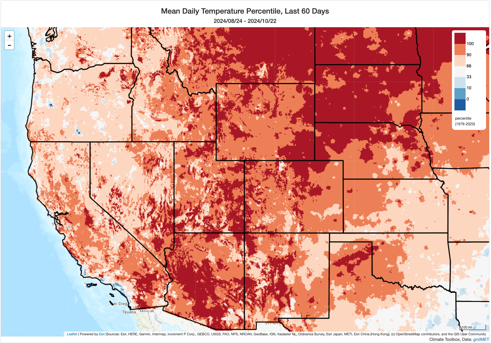
Record-breaking heat did indeed occur across much of California and the Southwest in early October, as predicted. And the heatwave that occurred was ultimately both more intense and more prolonged than even the rather severe event that was originally anticipated. But even California’s hot autumn to date doesn’t compare to what unfolded in Arizona during the same period: Phoenix experienced what was arguably one of the most extreme heatwaves on record (in terms of duration and magnitude of deviation from seasonal norms) in North America–experiencing three consecutive weeks during which *every single day* brought record high temperatures. And, despite false commentary to the contrary, this is not due to the presence of jet engine blasts on the tarmac at Sky Harbor airport or primarily caused by the “urban heat island effect” (which is quite real in big, sprawling cities like Phoenix–but simply not the cause of sustained and widespread record-breaking heat like this). Indeed: records fell by similarly huge margins elsewhere in the lower deserts of AZ and in rural areas in more mountainous, northern parts of the state. In short: it represents just the latest in a very long series of increasingly extreme heat events in the southwestern United States.
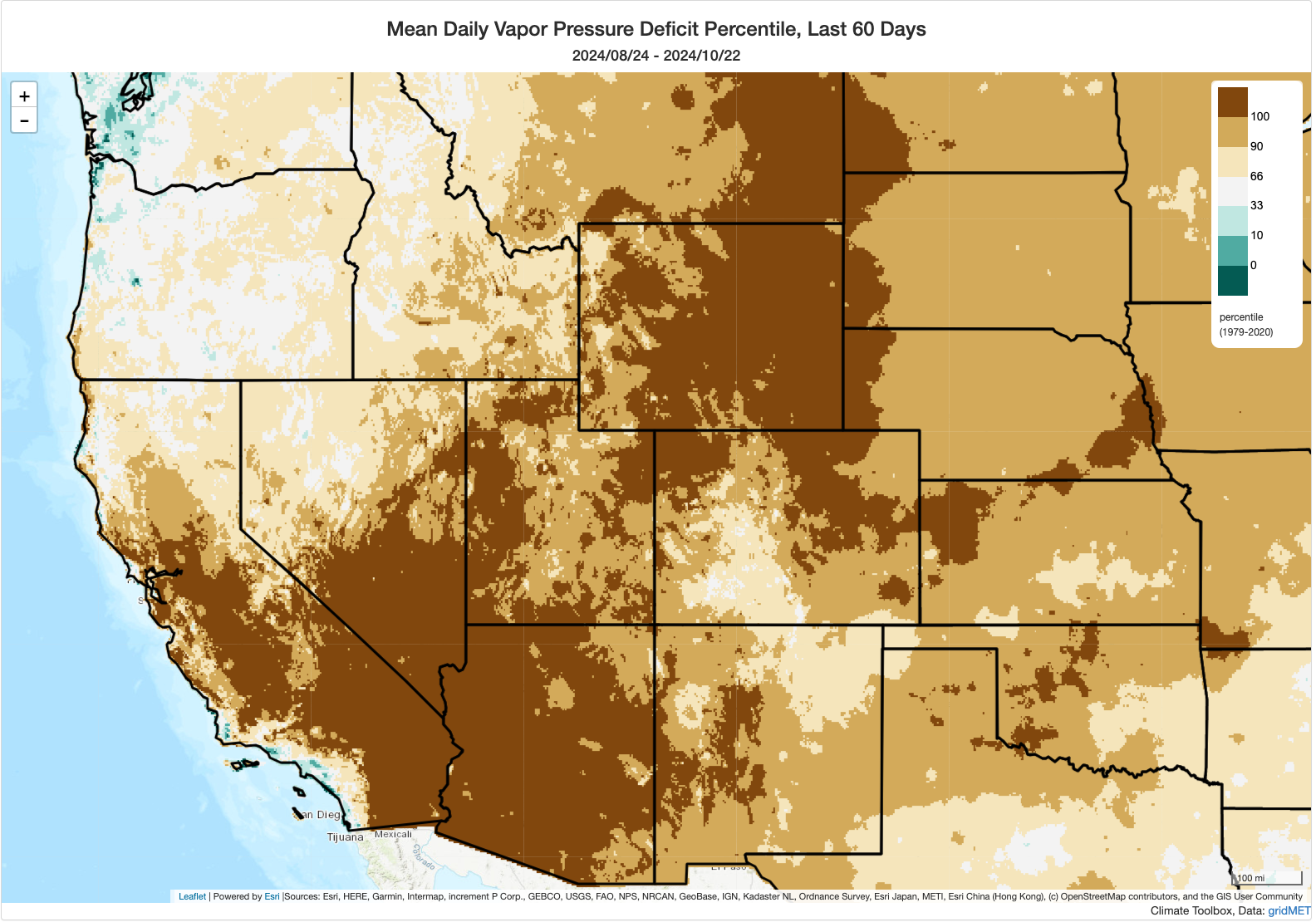
Notably, most of the West has been much drier than average during this period (with the exception of pockets near the Great Basin and near the Four Corners). Some spots have actually seen their driest Sep-Oct to date period on record, and in fact the contiguous United States is currently on track to experience its driest October (and perhaps any month) on record overall (a rather dubious statistic, given the already widespread drought across an unusually broad swath of the country at the moment).
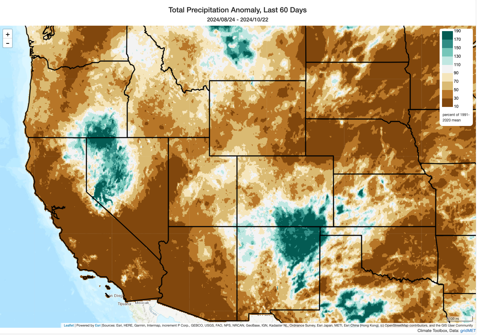
An active fire season continued during this period–considerably later than usual in many parts of the Rockies, stretching already dwindling seasonal fire crews thin. In California, while fire activity has again picked up relative to the comparative August lull, no highly destructive fires have occurred over the past month despite vegetation moisture levels approaching or exceeding record dryness levels for October at times (though there have been a few near misses). And a fair number of risk-reducing prescribed burns have been able to go forward on the less windy days–always encouraging to see. Meanwhile, the Bridge and Line fires in the SoCal mountains (which originally ignited in early September) have continued to flare up on occasion, but generally these have been interior pockets of vegetation burning and have not burned any further structures.
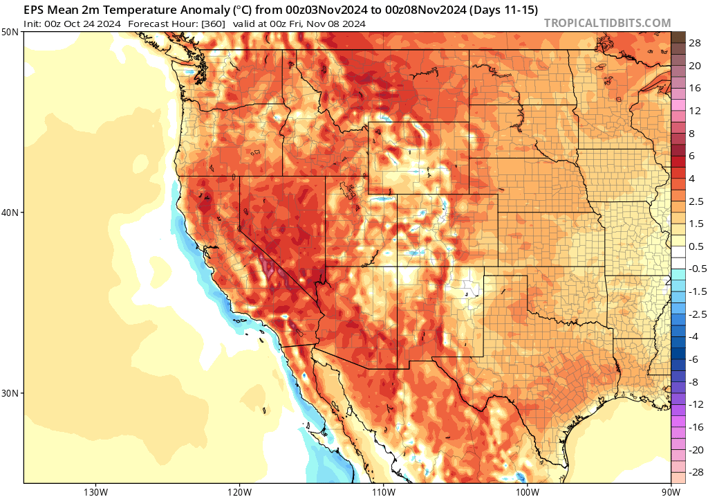
Despite some rain in portions of NorCal, mostly drier and warmer than average fall to continue into early Nov
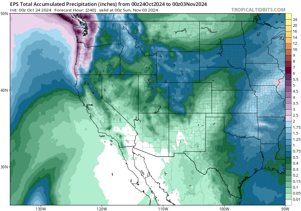
There will be some rain in California later this weekend and early next week–but it will be mainly confined to areas north of the Interstate 80 corridor and more substantial soaking rainfall will likely be limited (once again) to the North Coast and far northern mountains/Sierra. Some light showers will be possible as far south as about the northern San Francisco Bay Area, and some scattered showers could also occur in and near the Transverse Ranges in SoCal as the “inside slider” low pressure system makes its closest approach. But otherwise, most folks should stay dry during this period–and everyone will likely dry out again as we head toward early November with renewed anomalous ridging building back in along the West Coast. With the (mostly dry in central and SoCal) passage of this weather system, gusty offshore winds will be possible again (especially in SoCal).
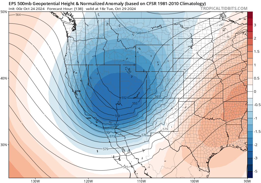
Right now, it appears there will be a somewhat cooler than average period again across most of CA and the West Coast at the end of October, possibly featuring (once again some NorCal and Sierra (snow?) showers) and mostly dry but breezy to windy conditions elsewhere. But by early November, there is decent inter-model ensemble consensus that ridging and above-average temperatures/below average precipitation will likely return to most of the West–perhaps continuing toward mid-November. There are even some ensemble members hinting at the potential for some fairly notable November (yes, November) heat in portions of the Southwest during this period, though it’s a bit too early to speculate further.
Fire season continues across central and southern CA; risk will continue to spike during offshore wind events
Although we have not seen a major autumn wildfire outbreak yet in California, we also haven’t seen widespread season-mitigating (let alone season-ending) rainfall south of about the I-80 corridor. In fact, vegetation moisture levels in parts of SoCal are now approaching record levels again following the early October heat and more recent dry winds–and even in the Bay Area conditions remain drier than average for the time of year. So fire season continues from about the SF Bay Area southward (less so to the north, where more widespread rain has fallen on a couple of occasions now and more will fall over the next week). That means that critical fire weather conditions can and probably will arise a couple of times over the next 10-14+ days, especially in the SoCal mountains and coastal plain where dry offshore Santa Ana winds (and relatively warm conditions) are expected periodically. Right now, none of the Santa Ana events in the forecast appear to be particularly extreme–but the magnitude of these events can be tricky to predict very far in advance as they are quite sensitive to the exact placement and depth of “inside slider” low pressure systems over the Great Basin (of which there will be at least a couple). So until widespread soaking rains arrive–and that is not looking likely south of about San Francisco for the next 2+ weeks–fire season will remain active and be punctuated by occasional higher-risk periods.
A special live events: Discussion on Earth system dynamics and “tipping points” with director of new documentary
On Friday, October 25 at 10am Pacific Time, I’ll host a special live event on YouTube. This will be different than my typical live office hours: I’ll be having a live conversation with the director (David Wallerstein) of a new short documentary focused on Earth system dynamics and potential “tipping points” on a warming planet. I’ll discuss some of the complexities involved in understanding how close we may be getting (or not) to pushing some critical Earth systems–like the Amazon rainforest and the Atlantic Meridional Overturning Circulation (AMOC)–into dangerous territory. How can we manage deep uncertainty, especially when it involves relatively low probability of extremely high consequence global phenomena? And how can folks make sense of the dizzying and often misleading array of news headlines and “scientific paper whiplash” as global interest and concern surrounding these topics accelerate? We’ll discuss this, and more–including the making of the film itself. (I both appear in it and was also a scientific advisor to the production team.) I’ll also be selecting some questions via the audience live chat to answer live–so please join us on Friday morning!
The film itself is now available on YouTube and other platforms–and can be viewed here!
Discover more from Weather West
Subscribe to get the latest posts sent to your email.