Wild Northern Hemisphere flow pattern throws predictions for a loop
An especially extreme hemispheric flow pattern over the past 10 days brought dramatic winter weather and widespread travel chaos across much of North America. One of the coldest airmasses in 30 years along the Rocky Mountain Front Range and Great Plains, paired with a rather dramatic cold frontal passage and associated low pressure development downstream, stranded tens of thousands of holiday travelers across the U.S. and unfortunately led to a blizzard in Buffalo, NY that killed many people (a somewhat startling event given that Buffalo hardly a stranger to very heavy snowfalls–this event, which combined very strong winds and heavy snowfall over a very prolonged duration, was historically severe) as well as yet another weather-related humanitarian crisis on the Rosebud Reservation in South Dakota.
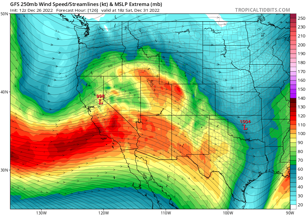
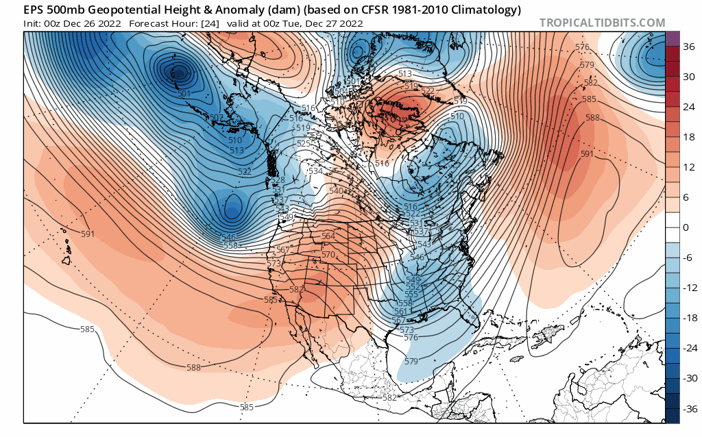
The numerical weather models really struggled with this extremely amplified pattern (where the jet stream ran more meridionally (north-south) than zonally (west-east, as is typical). As a result, weather predictions for most of December were more unstable than usual as even ensembles tended to be “underdispersed” (i.e., insufficiently wide ranging in their predictions to encompass the full range of plausible outcomes). As a result, the California December outlook oscillated from “pretty wet” to “quite dry” and has now swung all the way back to “quite wet” (as described in detail below).
Major (warm) NorCal storm tonight into tomorrow; further storms to follow (though probably weaker)
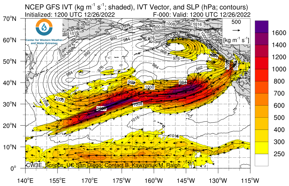
Long story short: a pretty strong storm will affect NorCal tonight, then weaken somewhat as it slides southward across central and southern California tomorrow. It’ll be a fairly classic strong winter storm associated with a robust atmospheric river, bringing widespread rain (heavy at times) to lower elevations along with strong and gusty winds, as well as heavy snow across higher elevations. Dynamics will be reasonably strong with this event, so even lower elevation areas could see some higher rain rates and gusty winds around the time of cold frontal passage. It will also be a notably warm storm, at least during the period of peak precipitation, with snow level potentially rising to 8,000 feet or higher during the peak of the event before dropping to more typical level after cold frontal passage. This is due to the subtropical origins of this particular atmospheric river–with some partial contribution from moisture near Hawaii (i.e., the Pineapple Express) as well as the West Pacific (aka the “Mango Express”).
Key impacts from this event: widespread heavy rainfall in NorCal, even up to 6,500/7,000 feet elevation initially. Local flooding due to heavy downpours and perhaps some amount of snowmelt at lower to middle mountain elevations (ponding of water on top of existing snowpack in places like South Lake Tahoe may actually be the most substantive flood risk with this event). Flood risk is mainly minor and restricted to urban areas/smaller streams, but some rivers will probably approach monitor or flood stage (though are unlikely to exceed flood stage by more than a trivial amount). Accordingly, some Flood Watches have been issued by local NWS offices in NorCal.
Winds will be strong and gusty, including at lower elevations, across most of NorCal. While this does not appear to be an especially extreme wind event, winds will likely be strong enough to cause some localized tree damage/power outages (probably the strongest frontal winds so far this season in many areas–always does a bit of “natural tree thinning.”)
Impacts will be lower in SoCal as the storm will weaken somewhat before reaching that far south, but some rain/wind will probably make it all the way down to the San Diego area.
I did want to note that, despite some claims currently circulating online, the storm due in tonight (while certainly strong and probably the strongest so far this season) is far from being historically severe (it’s no “ARkStorm,” that’s for sure). It will indeed be associated with very high integrated vapor transport (IVT) in NorCal–a measure of atmospheric river strength–that could put it among the top 10 or even top 5 such events in the past few decades. But IVT does not tell the whole story when it comes to the actual amount of precipitation received, and especially not when it comes to impacts. This AR, despite having very high IVT, will probably not realize its full precipitation potential due to relative lack of ideal dynamics (they will be decent, but not great). Also, antecedent conditions are not especially wet–we’re in the middle of a severe long-term drought, with rivers running low and dams well under capacity, and immediately following a fairly dry week. Although some minor and/or urban flooding is likely with this system, the flood-related impacts will likely be limited to the kind we see every season at least once. In fact, I’d even wager that the net impacts of this first storm will still be net beneficial given the drought–though the balance will be tighter than with storms earlier this season (since there will be some disruption and probably minor local flooding).
Active pattern could stick around for a while, including potential for “atmospheric river family”
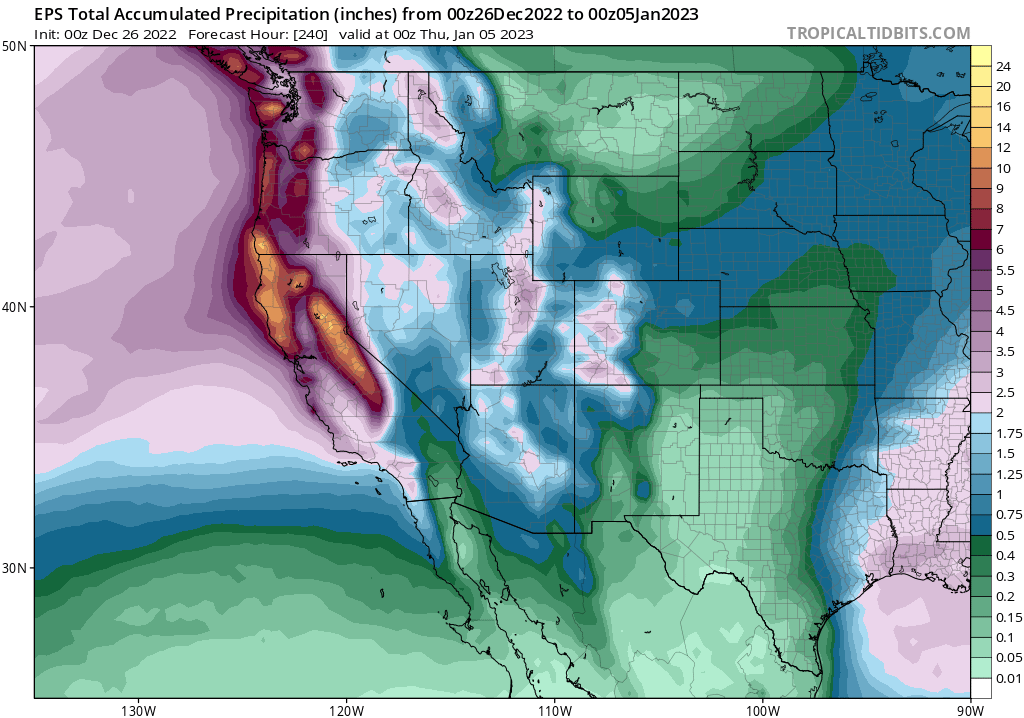
At the moment, it looks like this active pattern may stick around for a while. Details more than a week out are always a bit fuzzy, but in general the overall flow pattern over the North Pacific appears favorable for the “storm train” to continue at least into the first few days of the new year.
The next potential for a rather substantial storm is probably on New Year’s Eve. The details surrounding this event are pretty uncertain, since the latest model predictions suggest a rapidly developing low-pressure system amid a favorable dynamical environment over NorCal (upper-level divergence within left exit region of the jet, etc.). There’s a fair bit of boom or bust potential with this one–it could either be pretty strong (if the low pressure develops sufficiently) or rather unimpressive (if things don’t align quite right). Right now, it’s looking like it might be a moderately strong storm aimed directly at the Central Sierra, with the potential for some localized heavy rainfall and strong winds. Perhaps more impressve may be the heavy snowfall that could occur along and east of the Sierra Crest–this low pressure system may wrap some much colder air around the backside, potentially leading to much lower snow levels and much greater mountain snow accumulations than the warm and snow-melting storm due in tonight. Still a bit speculative, but this one has some potential.
After that, there are no specific indications of strong storms, but that doesn’t mean that one won’t pop up since the overall pattern is fairly favorable. At this time, I don’t foresee a high risk of flooding during this storm cycle since storms will still be fairly spaced out and appear to become progressively less strong/wet following the first one. But there’s at least a slight chance, if further storms come in a bit stronger or more closely spaced than currently indicated, the risk of more widespread flooding could rise somewhat (since soils will indeed be saturated and rivers running relatively high following this week’s activity). All in all, I don’t foresee anything all that out of the ordinary at this time–but I think this generous storm cycle will come as something of a relief for a lot of drought-anxious folks out there.
Does present active pattern change expectations re: Jan-Mar/May? No. But…
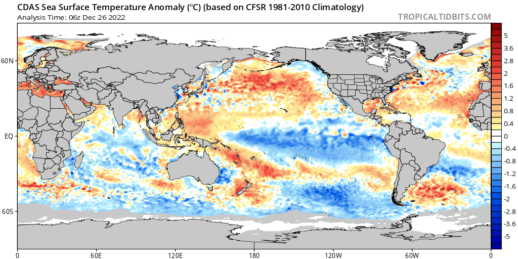
There has been a lot of speculation online regarding the upcoming active pattern–which does, indeed, in many ways resemble an “El Nino”-like sequence. In the short term, that’s a reasonable assertion–persistent low pressure in the Gulf of Alaska plus an extended East Asian jet slinging repeated winter storms toward California does resemble the canonical warm ENSO setup. But the problem with the claim that “El Nino has arrived early” is…well, it simply hasn’t! The tropical eastern Pacific is still much cooler than average, and although a pool of warm water continues to build in the tropical West Pacific–and shows some initial signs of slowly sloshing eastward–it hasn’t actually done so yet. The atmospheric teleconnections associated with El Nino simply can’t develop until anomalous warm conditions have been present in the east Pacific for a month or two–and that likely won’t happen at least until this coming spring or summer. For the Jan-Mar period (and likely the Jan-May period), moderate La Nina-like atmospheric patterns are still the most likely outcome. (I say “most likely” for a reason: it’s not the only possible outcome.) What we’re seeing at the moment, which over the next 10 days or so will decidedly not resemble a La Nina pattern, is likely due to a combination of transient subseasonal tropical forcing (brief El Nino-like atmospheric conditions in the tropics) and the aftereffects of very amplified atmospheric wind patterns in the wake of the recent extreme Arctic blocking pattern. That will likely be long gone by early January, and I still think it’s more likely than not that the second half of winter/spring will be drier than average across most of California and the Lower Colorado basin.
All of that said, what the upcoming very wet period does buy us is a decent amount of insurance: there will be quite a lot of water in the Sierra snowpack and soon in NorCal soil/rivers/lakes streams from the upcoming storm sequence. Even if things are indeed much drier than usual Jan-Mar, we have a pretty substantial buffer from our Nov-Dec activity in California. So I would expect continued partial drought amelioration in the short term (next 2 weeks). Although drought could worsen again with a dry second half of winter and spring, we will obviously be in better shape than what is turning out to be a pretty stellar December hadn’t transpired. Given that it now appears quite likely we’re headed for El Nino in the second half of 2023–and perhaps a strong one at that–I’d say that’s fairly good news heading into the new year.
Discover more from Weather West
Subscribe to get the latest posts sent to your email.