Extraordinary (and ongoing) heatwave brings all-time record heat to NorCal; Western wildfires surge
Let me just start by saying that this is perhaps the singularly most unusual and extreme weather week in quite some time in California–and that is saying something. Whew.
The (ongoing) extreme heatwave across California, the focus of my last blog post, has produced any number of benchmark-setting temperature records in recent days. Places in NorCal, including Sacramento, Livermore, Santa Rosa, and Ukiah, set new all-time high temperature records in the 115-117F range. Some places have shattered all-time September temperature records–and a few spots have re-broken all-time Sep monthly records consecutively for 2-3 days. Monthly and all-time overnight minimum temperature records have also been set as temperatures fail to recover much, especially away from the coast. Although the heat has been a dry one in NorCal, that has not been the case in SoCal–where densely populated coastal areas that largely lack air conditioning have been subjected to extraordinary and even Miami-like humidity along with the heat. This has been a heatwave for the record books–and one that, notably, the weather models predicted very well quite far in advance despite its highly anomalous/record-breaking nature. Thanks to aggressive electricity conservation measures by individuals and large industrial facilities, California narrowly avoided widespread rolling blackouts last night amid record-breaking electricity demand (though there were still some regional outages).
And the heat isn’t over yet–the interior of NorCal continues to experience temperatures that would be all-time Sep record-breaking but for the even higher temperatures earlier this week (so they are “merely” daily records now). Sacramento has already blown past its record for greatest number of 110 degree days in any calendar month, and will likely add at least 2 more before the week is over. In fact, the high pressure system responsible will actually re-intensify slightly tomorrow, bringing hotter temperatures again closer to the coast (and across SoCal).
In the meantime, California wildfire season has exploded over the past week, and there are now multiple dangerous and fast-moving fires of concern (as of this writing, the Mosquito Fire in Placer County and the Fairview Fire in Riverside County appear to pose the most imminent threats to life and property). Additional fires are possible over the next few days as extremely hot conditions continue and anomalous patterns/isolated lightning strikes occur ahead of a tropical weather system (which will be the focus of the rest of this post). And the recent heatwave has now pushed vegetation moisture well past record-dry levels in many places, setting the stage for extreme burning conditions given favorable weather conditions in the coming days/weeks. Suffice it to say…a converging record-breaking heatwave and northward-moving Hurricane make for an extremely challenging forecast. I’m going to dig into that now…buckle up.
Hurricane/TS Kay to make a historically significant close approach to SoCal
Hurricane Kay is currently churning off the west coast of Mexico, with sustained winds over 100mph. Kay is anticipated to take a north/northwestward path just west of the Baja California peninsula of Mexico over the next 48 hours–ultimately making a close approach and perhaps even entering the Southern California Bight. Tropical Storm Watches are now in effect all the way northward along the coast to the U.S./Mexico border–the farthest north I can ever recall having occurred. Seeing intact tropical cyclones this far north and east along the Pacific Coast of North America is quite rare–there are only a couple of other examples in living memory in which tropical storm or greater strength storms have gotten this close to SoCal.
I do want to be clear about one thing from the outset: Hurricane Kay is *not* going to make landfall as a hurricane, and it is also extremely unlikely that it does so as a tropical storm (perhaps a ~2% chance right near San Diego). But it is quite possible that portions of Southern California will see heavy rainfall and strong winds (indirectly, at least, from this event). In fact, I fully expect parts of San Diego County to see tropical storm force winds ahead of the tropical storm itself on Friday–but not for the reason you might expect. And even in the very unlikely event of a tropical storm-force landfall, the storm would feel similar in character to a moderate-strength winter storm in some areas (though with a few critical exceptions).
There is still great uncertainty regarding the actual track Kay will take, and this has major implications from an impacts perspective. Global model ensembles have converged on a track that brings Kay offshore of San Diego into the CA Bight as as a rapidly weakening tropical storm/depression, drifting westward away from CA before recurving back southward and dissipating offshore. Some of the high-res models, as well as hurricane-specific numerical tools, however, depict a much more eastward track for Kay–which might increase flash flood risk in the southeastern deserts of CA and AZ but greatly decrease rain potential across coastal SoCal. I do suspect the global models may still be a little under-dispersed with respect to Kay’s track forecast–meaning they were perhaps unrealistically clustered around similar tracks whereas a wider range of outcomes is still possible. At this time, I genuinely don’t know which outcome will occur–but I’m leaning toward the more western/wetter solution for the SoCal coast at this point given the global model ensemble convergence today.
It is also worth noting that has this storm trajectory been slightly different, and had ocean temperatures been slightly warmer than they are this year (say, due to a strong El Niño event…or global warming), it is entirely foreseeable that a storm like Kay actually *could* have made landfall near San Diego as a full-fledged TS-or-greater strength tropical cyclone. Some food for thought as folks ponder the historical context future potential of events like the 1858 Hurricane in San Diego, or the 1939 Long Beach Tropical Storm.
Myriad impacts possible from Kay and its remnants in SoCal: extreme fire weather ahead of storm, then potentially major flash flood risk from tropical downpours but also fire relief

Before any rains arrive, Kay might bring a surprising threat: extreme fire weather conditions may develop across parts of mountain and coastal SoCal amid strong easterly flow ahead of the storm’s northernmost rainbands on Friday. In fact, a pretty significant “tropical cyclone-induced” downslope windstorm and extreme heat event is possible in San Diego County on Friday. Record high temperatures along with strong sustained winds are possible in this environment, and there is even the possibility of a strong mountain wave developing over western San Diego County as precip begins on the eastern slopes of the SD County mountains but evaporates on the western slopes (similar in structure to what occurs along the Colorado Front Range in Denver/Boulder during winter, but with temperatures ~50-60 degrees warmer). This has the potential to produce locally very dangerous fire weather conditions for a 12-18 hour period prior to the onset of rainfall in parts of SoCal, especially San Diego County. There are some ongoing significant fires in SoCal right now, so this poses a potentially significant (if paradoxical risk) at the onset. It’s also why it’s unlikely that the National Hurricane Center will issue tropical storm warnings for coastal SoCal despite the high likelihood of TS-force winds: those winds, though potentially consequential, will actually be caused by a downslope windstorm only indirectly linked to the storm itself.
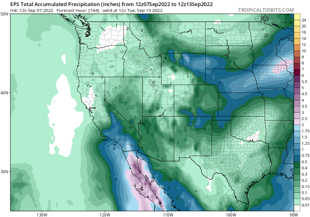
As Kay makes its closest approach, fire weather concerns are likely to fade rapidly as precipitation arrives (first on the eastern mountain slopes and southeastern desert regions, then later across coastal areas). Remember: easterly flow is downslope flow in Los Angeles and San Diego, so the models may be underestimating the degree of rain shadowing that could occur (especially initially). But this is where Kay’s exact track is going to make a huge difference. Precipitation accumulations will almost certainly be highest along the eastern slopes of the the SoCal mountain ranges, as well as perhaps in the Imperial Valley. In these places, very heavy rainfall could potentially occur (perhaps as much as 2 years’ worth in a 48 hour period in the driest spots in Imperial County, including Brawley). The NWS is highlighting a pretty high conditional risk of flash flooding in these regions due to Kay on Saturday, and there would be further enhanced concern in recent wildfire burn areas (there are several from just the past two weeks in this region on both sides of the U.S./Mexico border). Across coastal SoCal, rain will most likely be much lighter–but widespread showers and isolated thunderstorms (with some squally wind gusts) are a pretty good bet. San Diego might even see some effects from the outermost spiral rainbands of rapidly weakening Kay, depending on how much downslope drying/rain shadowing there is.
So, to sum up the possible Southern California impacts: a brief period of potentially very dangerous fire weather conditions prior to precipitation onset (especially San Diego County), then the potential for widespread showers/isolated thunderstorms. Rainfall in coastal areas will mainly be beneficial and a September “novelty” (probably knocking down fire risk down south for a while), but could pose a potential risk of serious flash flooding/debris flows on the eastern mountain slopes and SE desert regions/wildfire burn areas. And I fully expect there to be some pretty amazing satellite imagery of a tropical storm very close to California on Friday/Saturday…
Kay’s impacts in NorCal will be much lower, but potentially still notable: continued anomalous warmth, humidity, and possible dry lightning risk?
At this time, I do not expect Kay or its remnants to pose an especially high risk of high-impact weather conditions in Northern California. However, there is some potential for that to change depending on exactly how Kay’s residual moisture interacts with some weak troughs that may occur over NorCal in the coming days.
First of all, weak easterly flow on the northern flank of Kay’s upper-level outflow will interact with the existing heat dome to prolong the ongoing heatwave for an extra day or so. Extreme heat will finally fade, even inland, by Saturday–although conditions will remain warm, the potential for continued unusually warm overnight temperatures (but near average daytime temperatures). Humidity and mid-upper level cloudiness will likely be on the increase, as well, as Kay’s upper cirrus shield could perhaps reach as far north as the San Francisco Bay Area! But any rainfall is quite unlikely up north through Saturday, and likely beyond. However, there is a concern that any mid-level moisture streaming northeastward from Kay or its remnants could potentially be enough to trigger isolated to scattered elevated convection at some point between Sunday and Tuesday of next week. The models have been all over the places regarding this potential, so right now I’d say the odds of this happening are around 30-40%. Although modest, those would be conditionally very high fire risk days because of the antecedent record warmth and dryness. Fuels are about as receptive to lightning ignitions as they ever have been in NorCal–so even some wetter cells could still pose a risk of new fire ignitions if they occur up north. Currently no indication of anything approaching an August 2020-level event, but I would advice folks to keep a close eye to the forecasts as they may evolve considerably in the coming days.
So, to summarize: wetting rainfall or strong winds are unlikely due to Kay or its remnants in NorCal; most spots will see a cooldown and clouds rather than any rainfall. But there is a chance of some elevated convection developing at some point–which would pose a major fire weather risk *if* it occurs.
I’ll be following this very dynamic situation on Twitter this week as the forecast evolves, so stay tuned for updates!
Discover more from Weather West
Subscribe to get the latest posts sent to your email.