September was a hot month along the coast, especially in the north
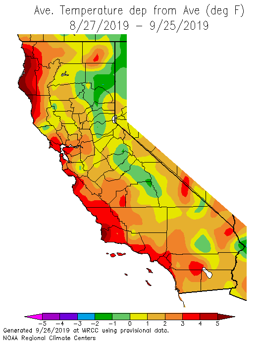
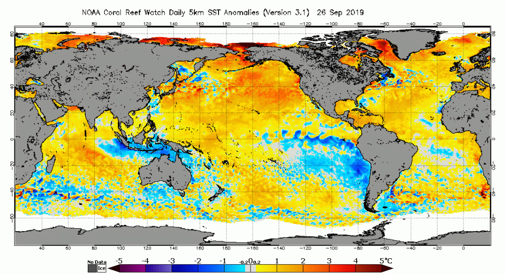
September is characteristically one of the warmest (if not the warmest) month of the year along the relatively narrow but highly populated California coast. The combination of reduced upwelling of cold ocean water and the prevalence of “offshore wind” patterns evolved in classic fashion over the past few weeks–bringing periods of very hot conditions even to the immediate coastline. Bolstered by extreme warm ocean temperatures well offshore, these otherwise typical autumn heatwaves have boosted coastal temperatures to record levels on several occasions, especially from the far North Coast southward toward the Central Coast. (For the record, San Francisco proper has now reached or exceeded 90 degrees on six days so far this year).
Temperatures across the interior of California were progressively less above-average as one moves inland–modestly warmer than typical September values across much of Southern California and the Central Valley, and right around average (or locally even slightly below) across most of the Sierra Nevada. Precipitation over most of the state, outside of a few localized thunderstorm downpours, ranged from unremarkable to zero.
Big cooldown headed for California; bit of early mountain snow likely
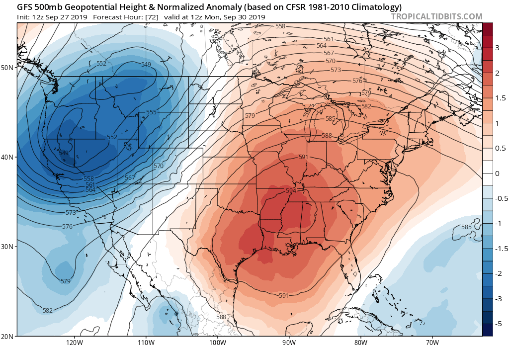
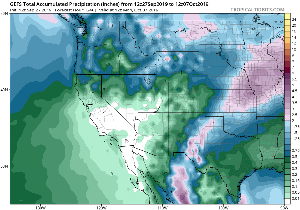
The record NorCal heat of earlier this week will be a distant memory by later this weekend as an unseasonably deep low pressure system carves out a trough across the entire western U.S. This system will bring very cold air aloft for the time of year, which will lead to scattered showers and a few isolated thunderstorms across far northern California. As a partial “Inside Slider” system, there will be little moisture associated with this incoming low and precipitation will be quite light in the far north and non-existent from the Bay Area southward. But in the Sierra Nevada, more widespread (if still light) precipitation is likely–which will be somewhat more notable given that it will all fall as snow above about 5500 feet! Several inches of early-season accumulation is likely across a broad swath of the Sierra Nevada Sat-Mon–which is not a whole lot, but it is falling pretty early in the season.
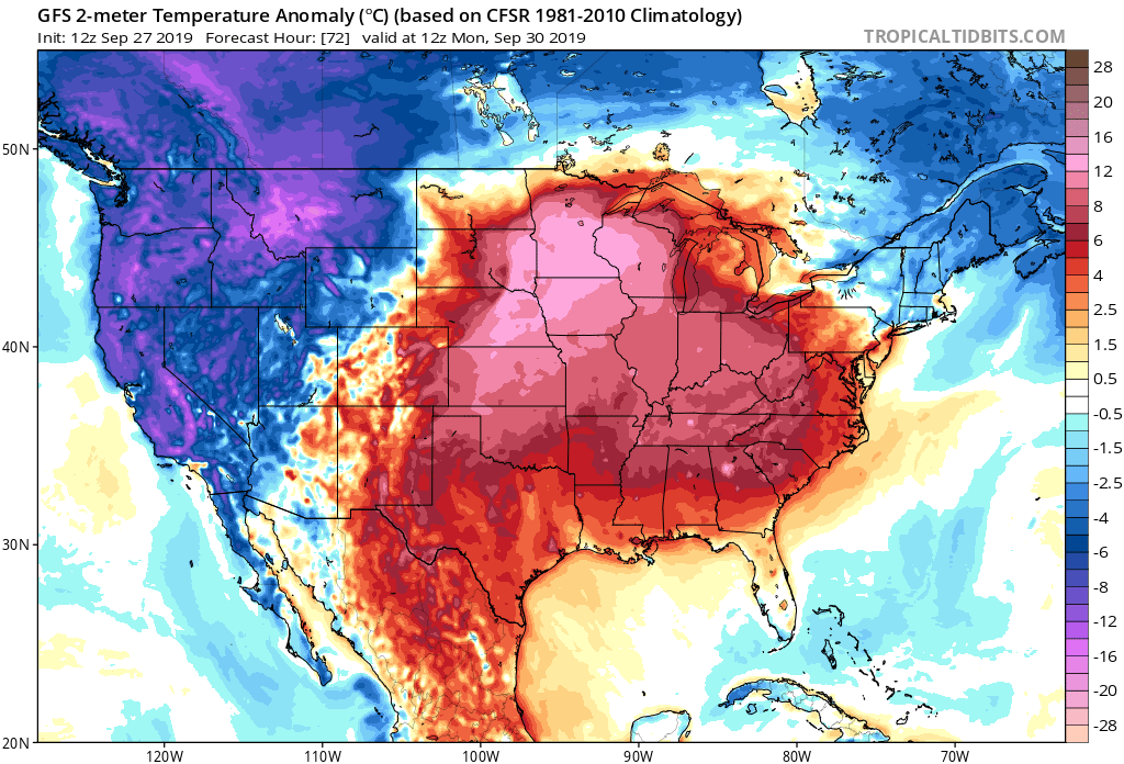
The main impact of this system (outside of the Sierra) will be the dramatic drop in temperatures it will bring. Much cooler than average temperatures can be expected for at least a 3-5 day period beginning this weekend–a welcome reprieve from recent heat in many coastal areas. Breezy to windy and dry conditions can also be expected at times, so there may actually still be some fire weather concerns to contend with over the coming week (although they don’t look especially extreme).
For the meteorologically-inclined (which I am assuming encompasses most of the readers of this blog!), the broader atmospheric pattern over North America this week will be pretty noteworthy. The deep and highly anomalous early-season trough over the West will produce a very heavy snowstorm over the northern Rockies–perhaps generating the largest autumn snowstorm in a generation over the Montana Front Range (where 2-3 feet of snow could fall over the next few days!). Early (and late) season snowstorms along the eastern slopes of the Rocky mountains tend to be the heaviest of the year–as that’s the time of year when summer-like moisture can combine with near winter-like cold (in the heart of winter, it’s often too dry for heavy snowfalls). Meanwhile: a very strong and persistent ridge will reinvigorate itself across the eastern and southeastern U.S.–bringing yet more record heat to a region that been baking almost continuously for the past two months amidst unprecedented late-season warmth.
Gradual warming trend late next week; no significant precip on horizon
After this weekend’s deep and cold Western trough finally departs later next week, temperatures will gradually warm back toward average values for early October. Thereafter, there is a fair bit of ensemble disagreement regarding whether the heat will return or whether milder conditions will dominate. One thing that does appear to be pretty clear is that after this weekend’s scattered NorCal showers and mountain dustings, prospects for further precipitation are very low through mid-October. That means that fire-season ending rains are not on the horizon for any portion of the state–and any heatwaves or offshore wind events during the second half of the month (which would not be especially unusual, from a climatological perspective) would elevate wildfire concerns once again.
Since September was a warmer-than-average month across most of California, but October will start out with a cooler-than-average week, it’ll be interesting to see how the rest of autumn pans out temperature wise. Long range outlooks do suggest that October may not be an especially warm month for most of the state (except perhaps along the immediate coast, due to continuing warm SSTs), but that November will likely be warmer than average again statewide. Seasonal projections for Sep-Nov had suggested a high likelihood for above average temperatures overall–and, to date, that has indeed been the case. Stay tuned!
Discover more from Weather West
Subscribe to get the latest posts sent to your email.