A September Yo-Yo in SoCal; Record hot to cool to hot again
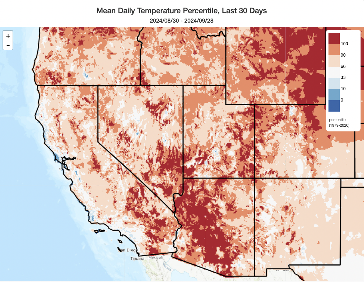
September was a bit of a roller coaster month in California (especially SoCal). In the southern half of the state, a record-breaking early Sep heatwave kickstarted a major wildfire outbreak that coincided with a major late monsoonal surge–leading to a dramatic mix of extreme heat, severe thunderstorms, flash flooding, destructive wildfires, and pyrocumulonimbus plumes. Then, not quite as dramatically but quite consequentially, a remarkably deep and cold early-season trough and associated low pressure system brought much cooler weather and even some localized precipitation in and near the SoCal fire zones (as well as in some other spots). A period of pleasantly near to slightly below average temperatures persisted thereafter–before anomalous heat returned at the very end of the month across most of the state.
Given all that whiplash, the “monthly average” can be pretty misleading in many areas (see much of Los Angeles County above depicted as having had “near average” temperatures for the month, despite that average being composed of record heat early on offset by highly anomalous coolness mid-month). Nevertheless, away from the immediate coast, nearly the entire U.S. West saw yet another much warmer than average month, including most of the land area of California. Parts of Arizona even saw their warmest September on record.
Major heatwave in early October, perhaps extending into mid-October in some places; some record heat possible (yes, again)
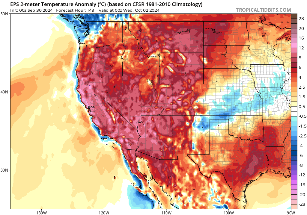
Well, here we go again: another major heatwave has already arrived, but won’t peak until Tue/Wed (along the NorCal coast) and then later this week (further inland across CA and the interior West). There are some indications that weak offshore flow could push temperatures around 100F all the way to the coast even in places like SF, which could make Oct 1 or 2 the hottest day of the year in these places (always a bit of uncertainty with these patterns as even a very weak seabreeze or slightly stronger offshore flow could push things in either direction). There may be some interior portions of the North Coast or SF Bay Region that see temperatures as high as 105-110F this week, and these would either be close to or even exceeding all-time October monthly records. In fact, (at least) daily high temperature records will likely be set somewhere in California each day from Tue through at least Sat, and possibly beyond (though in different parts of the state as the week progresses). Heat advisories and excessive heat warnings from the NWS are in effect for much of CA and the SW during this period.
Meanwhile, in Arizona, the beat goes on…and Phoenix will continue to experience an extraordinary and record-shattering string of mid-summer like temperatures that continues right on into October. I’m not even going to bother listing the specific heat records Phoenix is likely to break in the coming days because…it’s a long list.
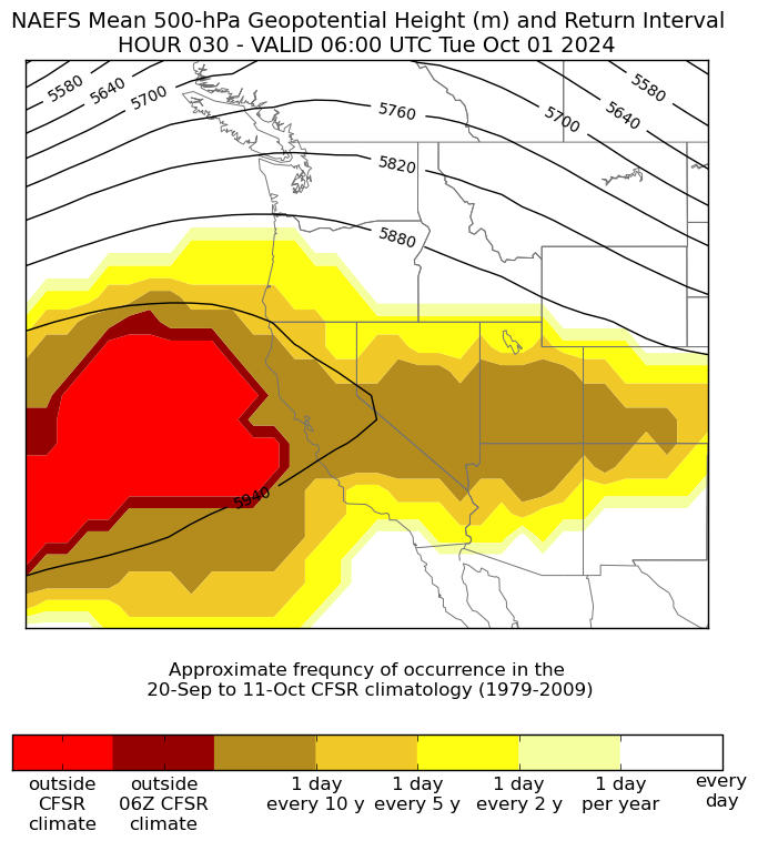
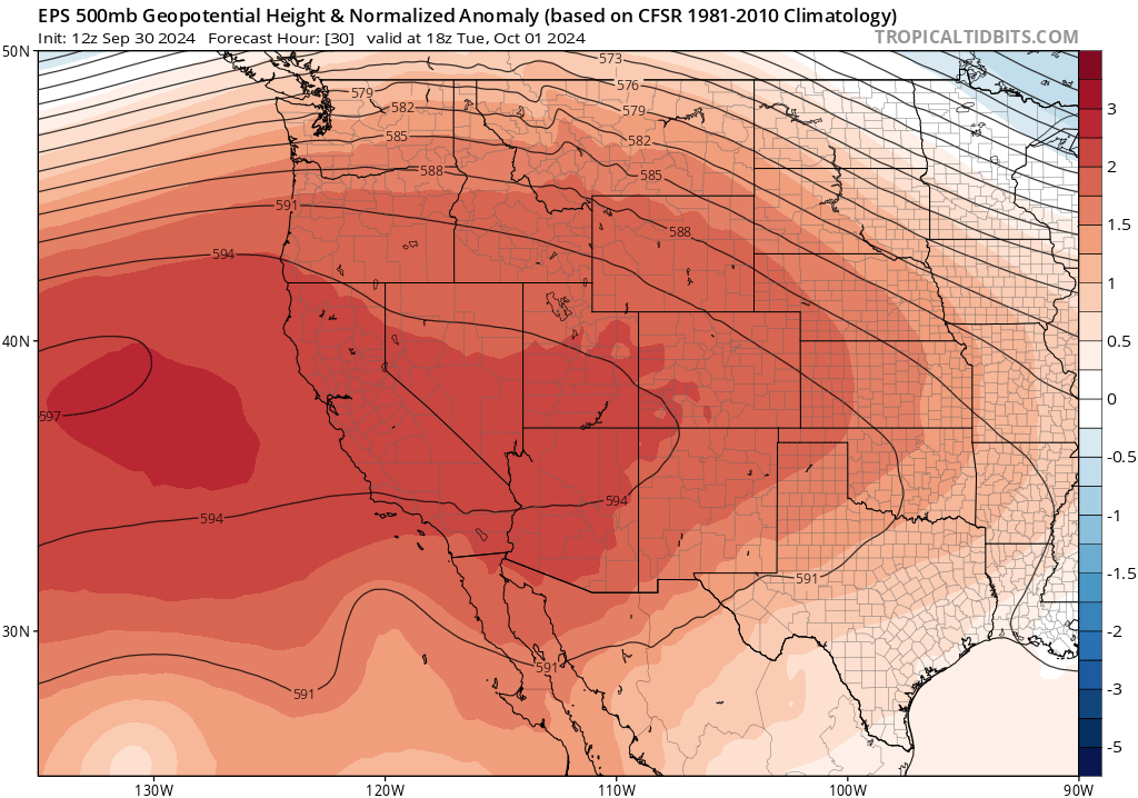
Why is it going to be so hot? Well, there are some familiar culprits–a record-strength ridge of high pressure at mid-levels (~500mb) of the atmosphere will be anchored just west of California this week. This will further adiabatically (compressionally) heat an already warm airmass to record levels for the time of year; this, combined with some weak offshore flow, is why hot temperatures will likely make it all the way to the beaches in NorCal this time around. As the ridge axis shifts inland this weekend, it will weaken below record levels (but remain much stronger than average), and it may re-strengthen closer to record levels again by early next week.
Wildfire risk rising again; no extreme risk periods apparent yet but that could change
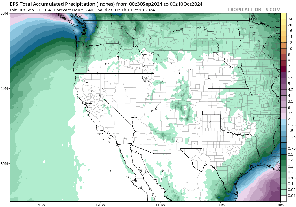
After another temporary reprieve period in mid-Sep, with cool weather and even some (localized) precipitation in patchy areas throughout CA, fire season is back in full swing this week. The Line Fire, which had been pretty inactive in recent days since it started during the record heatwave in SoCal during early Sep, roared back to life yesterday from within containment lines and various evacuation orders and warnings have been reissued. As of this writing, additional new fires are popping up in NorCal amid hot, dry, and breezy conditions. I would expect fire activity to continue to increase through this week as temperatures stay sustainedly high, even closer to the coast, and then also begin to pick up across the interior West again by this weekend as persistently very hot temperatures continue. As earlier noted: I suspect that places in the West that don’t usually see major wildfire activity in Oct or even Nov may do so this year (i.e., not just coastal CA, where such activity is not that unusual even later into fall given the typical seasonal lag in temperature there). There are no strong offshore wind events currently on the immediate horizon, though, which is the one piece of good news at the moment from a fire weather perspective.
Modest relief next weekend, but yet more late-season heat may return after
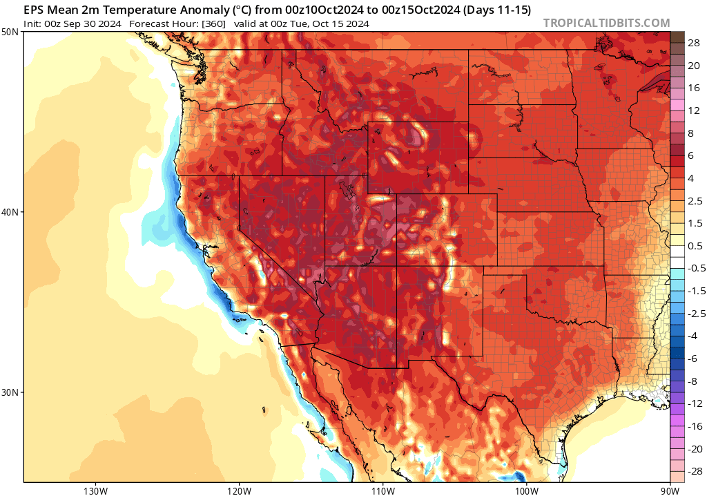
Right now, it sure looks like the early seasonal outlooks–which have been screaming “much warmer than usual” and (hinting) at a tilt toward drier than usual Sep-Oct–are coming to pass. There is multi-model ensemble agreement that a broad ridge will persist across the Western U.S. for at least the next 2 weeks. It will wax and wane in intensity somewhat during this period, and there may even be the potential for brief showers in the PacNW and perhaps making it as far south as the North Coast. But generally speaking, the next 14+ days appear to be an exceptionally hot and dry period across nearly the entire West (except maybe Washington state, where rain is likelier). During this period, there may be additional periods of record warmth (especially across the SW interior, but perhaps also closer to the coast on days where at least offshore winds can develop). At this time, this does not look like a highly conductive pattern for strong offshore wind events (fortunately, from a fire risk perspective), but at least brief/occasional weak to moderate north/east wind events will still be possible during this window and that will lead to persistently elevated (and briefly critical) fire weather conditions across California and much of the rest of the West through mid-Oct. It will also reinvigorate fuel drying, meaning that if any major wind events do develop farther down the line (late Oct or early Nov), extreme fire weather conditions may be possible at that time due to the combination of extremely dry vegetation stemming from the legacy of what was a record hot summer in many regions and what is turning into a record warm fall (or nearly so) in others.
A catastrophic, “ARkStorm-level” flood in Southern Appalachia
Last week, Hurricane Helene made landfall at Category 4 strength along the Big Bend coast of Florida, sending a record-breaking 15-20 foot storm surge ashore (albeit in a region with fortuitously low population density). However, what happened next was far more catastrophic: Helene’s remnant circulation made a beeline for the Southern Appalachian mountains, bringing a round of record-breaking torrential tropical rainfall. This rain event came immediately on the heels of another record-breaking rain event just one day prior, though this one too was indirectly associated with Helene (in the form of a “predecessor rain event,” or PRE). The next result is the worst regional flood catastrophe the United States has seen in some years (and likely the worst this region has experienced in recorded history). 20-35 inches of rain fell in less than three days in steep and mountainous terrain, causing rivers, creeks, and streams to not only spill their banks but literally carve new paths through mountain valleys–regardless of what was in the path. Numerous small towns and substantial portions of larger ones have been decimated; well over 100 are confirmed dead and hundreds remain missing. Large parts of western North Carolina are still cut-off from the outside world, several days later, and news from the hardest-hit areas has yet to emerge (since telecommunications, as well as nearly all roads, powerlines, and water pipes) have been damaged or destroyed.
This event is a disaster of national significance in its own right; it is also relevant from a California perspective because this is essentially an “ARkStorm“-like scenario come to life (albeit in a different region, and resulting from a different type of extreme rain event). California faces a real risk of similarly catastrophic flooding, though perhaps on an ever broader geographic scale–a risk that is rising with each additional fraction of a degree of global warming–but it remains out of sight, and out of mind, for most folks. If you are interested in learning more about the Sep 2024 flood disaster in Southern Appalachia, I’ve included a widely viewed social media thread below (you can find the same thread on all other social media sites on which I have a presence, too). To learn more about ARkStorm and flood risk in California, you can check out my 2022 Weather West post on the topic.
Another double-header live & interactive office hours session on YouTube: CA heat plus SE flood catastrophe
On Tuesday afternoon, I’ll have another YouTube live session focused on two separate topics: a) the unfolding, prolonged, and in some cases record-breaking October heatwave in CA and the SW, and 2) the aftermath of the catastrophic regional flood event stemming from Hurricane Helene in the mountains of western NC/SC and eastern TN. Join me live at 3pm PT Tue (Oct 1); bring your questions.
Discover more from Weather West
Subscribe to get the latest posts sent to your email.