Early Feb NorCal wind and SoCal rain events were historically significant
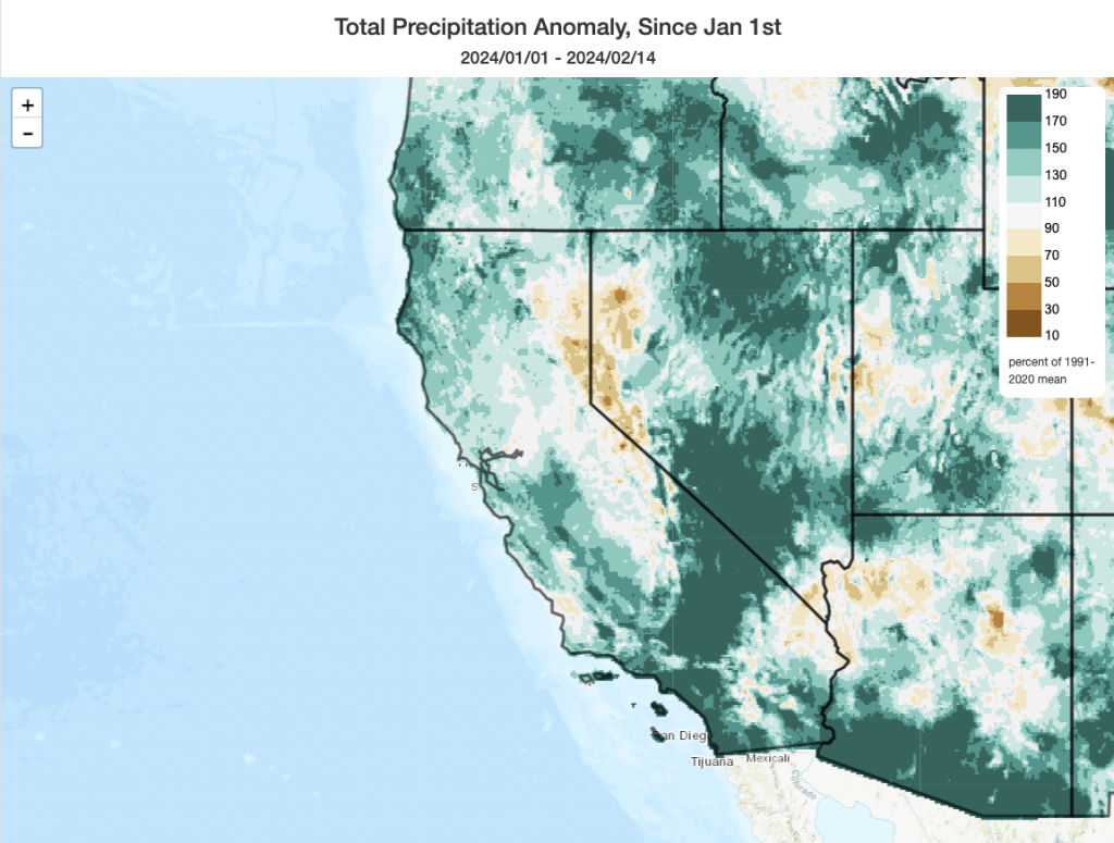
February started out with a remarkable pair of Pineapple Express-type atmospheric river storms, each of which brought substantial impacts, but the second of the pair ultimately generated extreme wind gusts in parts of Northern California and historic rainfall in portions of Southern California.
Wind gusts of 80-100 mph along the coast and ridges resulted from the 978mb “bomb cyclone,” which rapidly strengthened while it was just west of the San Francisco Bay Area, with far more widespread gusts of 50-75mph elsewhere across much of the Central Coast, SF and Monterey Bay Areas, Mendocino coast, and much of the Central Valley. At one point, over 2 million people were likely out of power due to countless downed trees and power lines (some for multiple days). Unfortunately, the severe windstorm was also a deadly one, with at least four deaths reported as a direct result of falling trees.
Meanwhile, across SoCal, a remarkable rain event unfolded across Santa Barbara, Ventura, and Los Angeles counties. LA County, in particular, bore the brunt of these historically heavy falls–with some parts of the city proper (not the mountains above, but right on the coastal plain) logging between 8 and 12 inches of rain over just 48 hours. On UCLA campus, this represents the heaviest 2-day rain event ever recorded by a considerable margin (Feb 4-5 total value of 12.8 inches (!); records there go back to 1933). In fact, if current forecasts for substantial additional rainfall hold, parts of coastal southern California will likely end up experiencing one of their top-3 wettest months on record in February 2024.
Literally hundreds of mudslides and debris flows were recorded in Los Angeles County during this event (with hundreds more elsewhere statewide). Although most were relatively minor, some did damage or destroy structures although thankfully none appear to have resulted in any fatalities. Urban and street flooding was, as you would expect, widespread and significant. But in broader terms, this was NOT “The Big One” when it comes to California flooding, even in a Los Angeles-specific context. It’s certainly good news that more severe flooding was not widespread and that a higher death toll did not occur. But, contrary to some high profile comments prior to and following this historic rain event–“ARkStorm” it was not. (A real-world occurrence of an ARkStorm-like scenario would involve a much longer duration and even greater intensity of storms than what we just observed.) One factor that prevented more severe flooding or debris flows during this event, despite record-breaking 48-hour accumulations, was that hourly and sub-hourly rainfall rates mostly stayed manageable. Had we seen more intense or widespread convective elements embedded within the AR plume, there might well have been more severe/life-threatening flash flooding than was actually observed.
Also worth noting: two damaging and relatively long-tracked (by CA standards!) tornadoes from this event were confirmed along the Central Coast by the NWS in Oxnard.
Another pair of big storms is headed for CA, though not as intense as early Feb
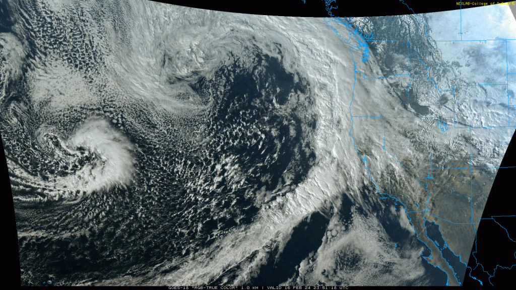
And now: here we go again! Well, not quite. While there is a pair of strong and wet storms headed directly for California once again, they don’t appear to be as strong or as moist as their early February predecessors (fortunately). On the one hand, the significant antecedent wetness raises the stakes from a flood and mudslide perspective: soils are already saturated, and rivers/creeks are already running relatively high. On the other hand, these storms do not appear to be as intense dynamically nor have as robust as a deep subtropical moisture tap as the early Feb storms. So I’d crank the potential flood-related impacts up a notch due to the wet preexisting conditions, but down two notches due to the less extreme nature of the actual storms themselves. (This is especially true from LA County south and eastward, where rainfall from this event will likely be less than half that of the early Feb storm).
There will be some broad structural similarities: the first, weaker storm will come through quickly tonight into tomorrow–bringing a relatively short burst of moderate to locally heavy precipitation in NorCal (tapering off to nothing in SoCal). It will then be followed be a much stronger and slower-moving storm Sunday into Monday–which will bring both heavier rainfall, stronger winds, and perhaps some substantial thunderstorm activity as well. And it will also be riding a strong Pacific jet streak centered (once again, in classic El Nino-like fashion) over Southern California. But one major difference is that while the Sunday storm will deepen significantly due to favorable jet structure amid a baroclinic environment, it will likely do so much farther offshore and will not concentrate that energy into a smaller, compact low pressure center. Instead, this system will peak in strength while it’s well offshore, be weakening slightly as it approaches the coast, and will remain as a fairly broad/diffuse low pressure center.
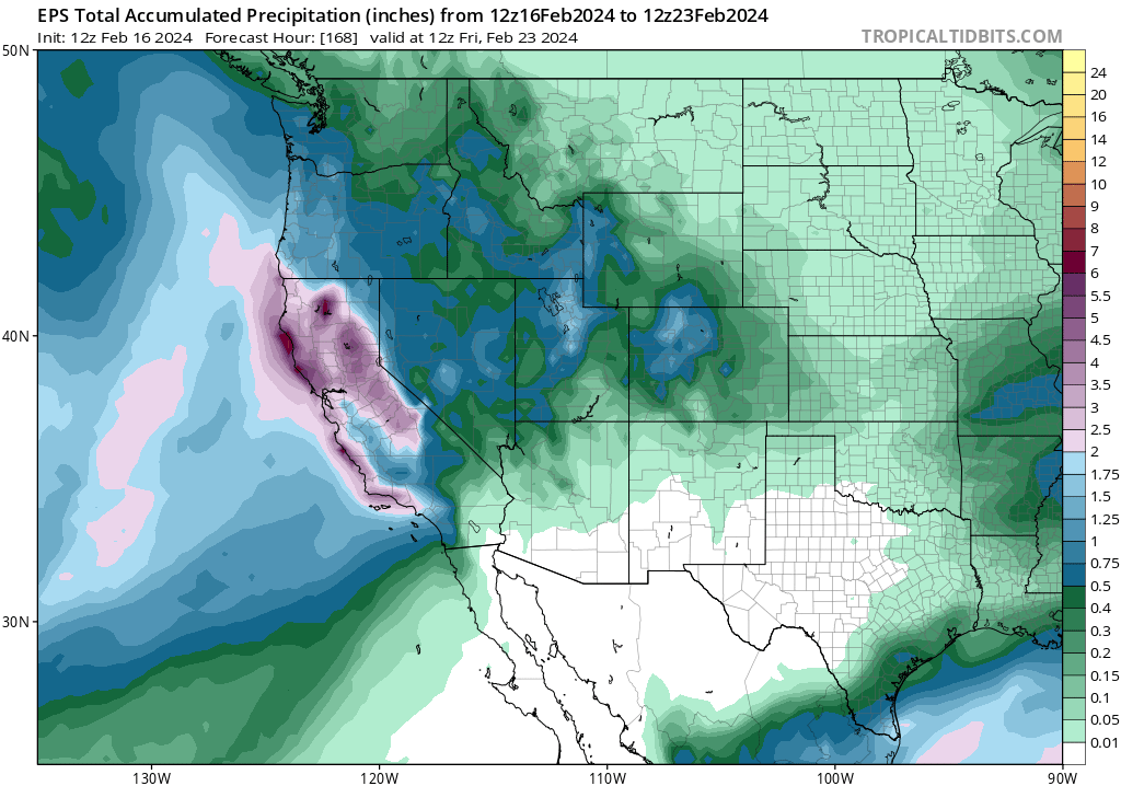
What does this all mean in practical terms? Well, first, although it will be windy in many areas (and some localized power outages will be possible once again), peak winds will be anywhere from 20-40 mph lower in most areas in NorCal than during the early Feb event (so this will most likely be a much lower impact wind event overall). Second, rainfall in SoCal will likely be less heavy than the previous event (although it could be similarly heavy or even a bit more so than the Feb storm in NorCal). That means that the areas likely to see the heaviest rainfall from the upcoming event (northern and “upper” central CA from about Santa Barbara County northward) will not be the areas that saw the heaviest rainfall from the early Feb event (Ventura into Orange County). That likely means the potential flood impacts will be more widespread but less intense than if this system were also focused on the very same areas.
Increasing flood risk across much of NorCal and Central CA
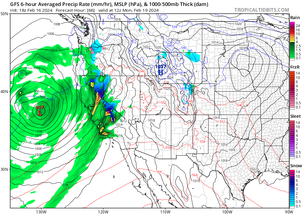
All of that said, most of NorCal and parts of SoCal are now under NWS Flood Watches for this weekend. Substantial urban/small stream flooding, and maybe also some modest smaller river flooding, is possible across much of NorCal (the southern Sacramento Valley, which was especially soaked in early Feb, may see some elevated flood risk in comparative terms since it’s likely to be very wet again with this storm cycle). So fairly widespread flood and local mudslide issues are plausible Sun into Mon, although they are unlikely at this point to be especially severe. One possible exception? If the offshore low “bombs out” closer to the coast than expected, or if the AR plume stalls due to a mesoscale frontal wave somewhere between the SF Bay Area and LA County, or if particularly intense convective downpours develop on Mon, more serious flooding will be possible in a relatively narrow 50-100 mile band somewhere. At this point, that’s not super likely (maybe 10-20%), and would not be widespread, but it’s worth keeping an eye out for as conditions evolve this weekend.
Some stronger thunderstorms on Mon, especially Sacramento Valley?
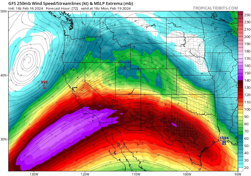
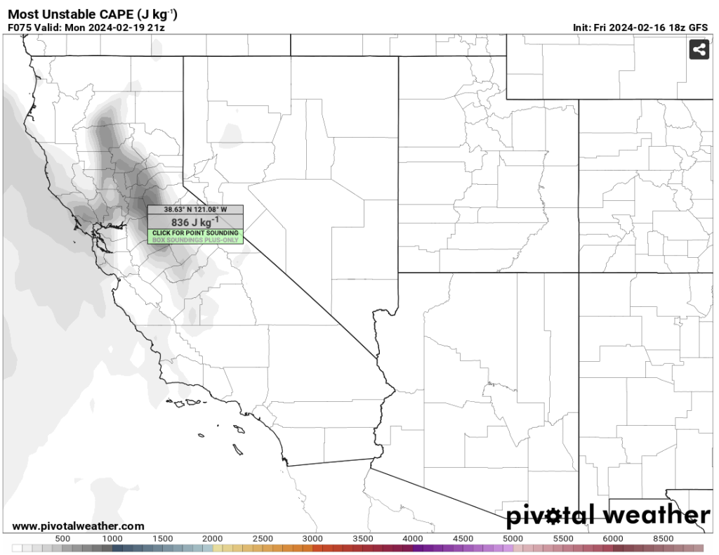
One additional aspect of this storm that looks increasingly interesting is the potential for some strong to severe thunderstorms across portions of CA, especially on Monday. Right now, several models are spitting out fairly high levels of surface-based instability (CAPE of 500-1000+ J/kg, which is high by CA winter standards) across much of the Sacramento Valley and portions of the SF North Bay on Monday late morning and afternoon. Due to the favorable position relative to the SoCal jet streak, which will provide some mesoscale lift and a bit of wind shear, it’s plausible that there could be some hefty thunderstorm activity especially if there are enough breaks in the cloud deck for some differential heating (which appears possible). Scattered thunderstorms with some isolated low-topped supercells are not out of the question in these areas on Mon PM, which could bring some locally substantial hail and even an isolated tornado or two (as we’ve see in prior similar setups). There will also be a notable though smaller chance of some strong to locally severe thunderstorms along the Central CA coast late Sun into Mon, and some locally torrential downpours and a waterspout/brief coastal tornado may be possible once again as a result.
I’ll likely have a live YouTube check-in some time on Sun and/or Mon, depending on how things develop. Stay tuned!
Cooler and unsettled conditions late Feb into early March?
There are some early signs that colder and somewhat unsettled weather pattern may develop across California late in Feb and into early Mar, which would perhaps favor more widespread and substantial Sierra snow accumulations down to lower elevations. But there will likely be a drier interlude in between the current significant storm pair and that potential pattern shift over the Pacific, so we’ll cross that bridge when we come to it!
In case you’re interested: A (candid!) perspective on my work and life these days
Stanford Magazine just published a fairly in-depth story on what it’s like to be Daniel Swain these days. Frankly, the level of public attention in recent months focused on my life and professional role as a climate scientist-communicator has been humbling and a bit overwhelming! But given the audience (you’re all reading my weather and climate blog, after all!), I surmise that some of you may be interested in reading the article (which offers, more than most, a candid view of what my day-to-day looks like). Many thanks to the author, Tracie White, for coming out to visit me and for some great conversations.
Discover more from Weather West
Subscribe to get the latest posts sent to your email.