Brief reality check: a quick look at the season thus far
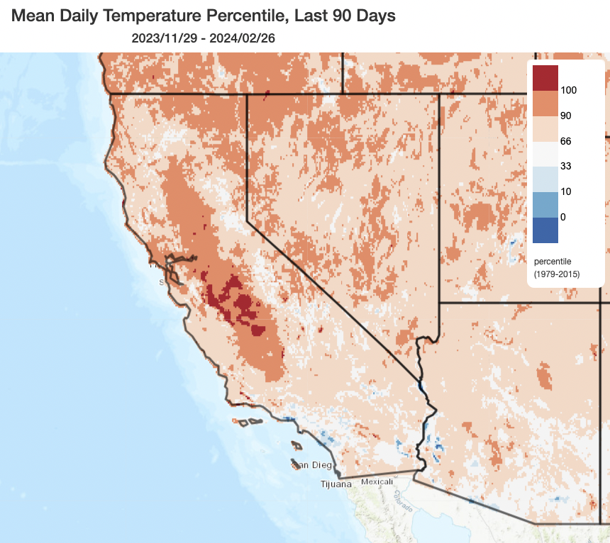
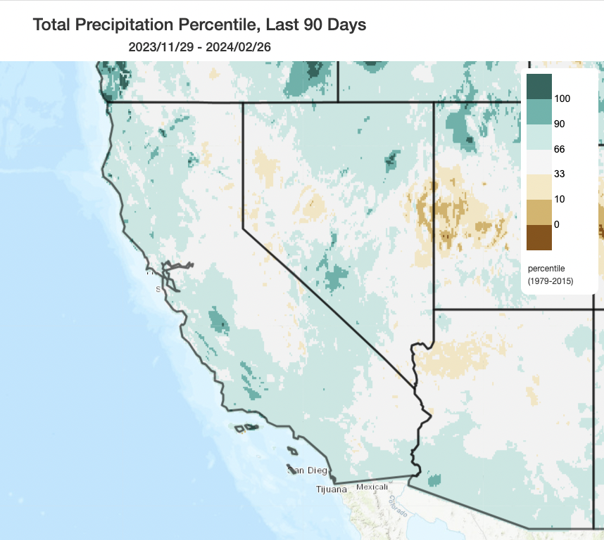
Winter 2023-2024 has turned out to be an eventful one despite a pretty slow start in December. Overall conditions have been substantially warmer than average across essentially all of CA, with some parts of the San Joaquin Valley seeing winter temperatures approaching seasonal records. Precipitation has been a bit more heterogeneous, with December starting out fairly dry in most places but January and February being extremely wet in some places. Overall, precipitation for the past 90 days has been above average essentially everywhere within 100 miles of the CA coast and near to slightly below average inland across the Sierra Nevada (though that’s going to change quickly in the next 72 hours!). Overall, DJF will end up warmer and wetter than average for most of CA’s land area and the vast majority of its population (and JFM precipitation anomalies may yet be even higher on the wet side).
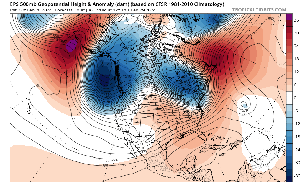
Sequence of much colder storms (than so far this winter) headed for CA
Storms so far this season have primarily favored coastal regions from about the SF Bay Area southward, and have hit portions of the Central Coast and SoCal coastal plain hard with very heavy rain and flooding in recent weeks. Meanwhile, the Sierra Nevada has been left comparatively high and dry (though not extremely so). Well, the upcoming pattern will be a nearly ideal one to “fill in the gaps:” widespread heavy snowfall is likely in the Sierra with widespread moderate rainfall elsewhere in the coming days. Flood risk will be kept to a minimum by the lack of a substantial subtropical moisture tap (unlike Pineapple Express-type storms earlier this season) and by low snow levels, which will allow much of the heaviest precipitation to accumulate as snow rather than immediately becoming runoff. And the good news is that the heaviest precipitation will fall in the places that have been relatively driest so far this season, sparing sodden SoCal but soaking/burying the drier Sierra. (But that will cause its own problems–more below!)
Aside from genuinely extreme snowfall potential in the Sierra (discussed in more detail in the next section), much of the rest of California will see widespread albeit mostly moderate (perhaps briefly heavy) cold rain. There will be some potential for gusty winds in NorCal, though outside of the Sierra these wind gusts will be fairly unremarkable for a winter storm (staying mostly under 50-55 mph and well below that (more like 30-45 mph) in most areas away from hilltops and the immediate coast). This system, like many of its predecessors, may be associated with a fair bit of thunderstorm activity (those warmer than average near-shore ocean temperatures are still playing a role), though this time the risk of severe weather will be fairly low and the bigger issue may be localized accumulations of small hail north of the SF Bay Area and along the North Coast in particular.
Outside of the Sierra Nevada and some select areas along the North Coast/Mendocino region affected by unusually heavy lower elevation snowfall, this will probably not be a notable storm. But at higher elevations, things look a whole lot more dramatic…
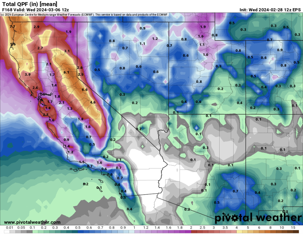
Extremely heavy snowfall in Sierra, with rare widespread blizzard conditions likely late Thu-early Sat
If you’re thinking about heading up to the mountains for a “powder weekend,” I’d strongly encourage you to reconsider. Extreme snowfall rates and strong winds will combine to make road travel essentially impossible (and certainly dangerous) beginning by late Thursday afternoon and continuing through at least early Saturday afternoon–if not longer–across essentially all of northern and central California above 4,000-5,000 feet elevation (and locally as low as 1,500-3,000 feet elevation in northwestern CA, Shasta County, and perhaps parts of Mendocino and Lake counties). It’s likely that all roads, including major highways like I-80 and US 50, will be completely shut down for much of this event. And ski resorts probably won’t be able to run chairlifts amid strong wind conditions, either.
For those who live at higher elevations, including those in the Tahoe Basin: this will be a very heavy and possibly highly disruptive snow event. This might come as a bit of a shock given how anemic this year’s snow season has been thus far at Lake level, but this one looks like the real deal. The range of potential outcomes is from a very heavy but mostly manageable 2-3 feet in places like South Lake Tahoe (in a lower end scenario) to perhaps as much as 4-5+ feet could fall in more heavily populated parts of the Basin over a 2 day period (in a higher-end scenario). At higher elevations (above 6,000 feet or so), 5-10+ feet (clarifying units here!) of snow could fall in less than 96 hours . Thus, above 5-6k feet elevation (and locally below), this is virtually guaranteed to be a dangerous and disruptive snowstorm. Given that strong winds will accompany this extremely heavy snow (which could fall at rates of 2 to even 5 inches per hour at times), formal blizzard conditions will likely occur in many areas. The National Weather Service has accordingly issued an (uncommon) Blizzard Warning for a wide swath of the Sierra, unusually including areas well below Sierra crest/pass level.
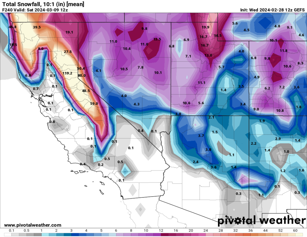
I would not too surprised if some spots on the Sierra western slope or near the crest experienced 1 or 2 day snow accumulations that would rank among the top 5 historical events on record. We’ve actually seen a number of such events in recent years, despite the long-term decline in Sierra snowpack and a number of record low snowpack years over the past decade. In some ways, that actually makes such events even more disruptive than they might be otherwise–the “snow whiplash” incurred by rapidly swinging from unusually low snow conditions to historically intense individual snowstorms can be decidedly difficult to adapt to if you live in affected areas.
Snow levels will be quite low along the North Coast and far NorCal (dropping down to 1,000 – 1,500 feet by the end of the storm), and fairly low in Mendocino and Lake counties as well (perhaps as low as 1,500-2,000 feet). These are not exceptionally low snow levels–and snow will not fall to as low of elevations as it did last winter (in the SF Bay Area and southward, snow is fairly unlikely below the unremarkable elevation of 2,500 feet or so). But these are exceptionally low snow levels in the context of the large amount of frozen precip that may fall at unusually low elevations in certain areas. So, once again, the 1,000-2,000 foot elevation band in NW CA north of the SF Bay Area may experience considerable disruption (to road travel, and possible electrical infrastructure) because of heavy, wet snowfall at elevations that do not generally have infrastructure needed to deal with it.
Why will this storm, specifically, produce so much snow with so much confidence in the Sierra Nevada, unlike so many other storms this winter? Well, the depth of the offshore low pressure system at middle and upper levels of the atmosphere will be highly anomalous for the time of year–and that will give rise to unusually strong middle-altitude winds (at 700mb level or so) that will drive very effective orographic uplift across the Sierra. Then, the frontal system itself is pretty strong from a dynamical perspective, with a well-defined cold front and favorably positioned jet stream moving right across the Central Sierra.
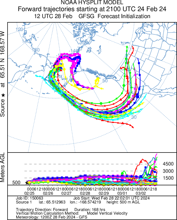
But the other component that has been missing thus far this winter and in many other storms historically is the modified Arctic airmass that will accompany this storm. This will not be an exceptionally cold airmass by historical standards–in fact, the predicted 850 mb temperatures of -2 or -3C around the Bay Area occur essentially every winter at least once, if not more often! But the fact that such cold temperatures will actually coincide with the peak storm intensity over the Sierra makes this event stand out. Instead of a colder airmass arriving after the main precipitation has moved on, it’ll persist for the entire duration of the event. To visualize why this is happening, I plotted a projected trajectory map for an air parcel originating in the Bering Strait between Alaska and Kamchatka (see below) beginning four days ago and continuing 7 days into the future. As you can clearly see, that cold Arctic air is surging southward from western Alaska then immediately eastward–taking a pretty efficient overwater trajectory directly toward northern California. Now, because it’s spending 4-5 days over the Pacific Ocean, this will be what’s known as a “modified” Arctic airmass because it has been substantially warmed and moistened (i.e., “modified”) by this multi-day oceanic influence. But the combination of a modified Arctic airmass with relatively high moisture content with a slow-moving and rather strong low pressure system is highly unusual in California, and this is what will cause such remarkable snowfall rates and total accumulations in the higher mountains (despite not bringing extremely cold surface temperatures or extremely low snow levels). It’s the sweet spot of a “cold enough” and “moist enough” and “uplifty-enough” setup, and those don’t come along too often!
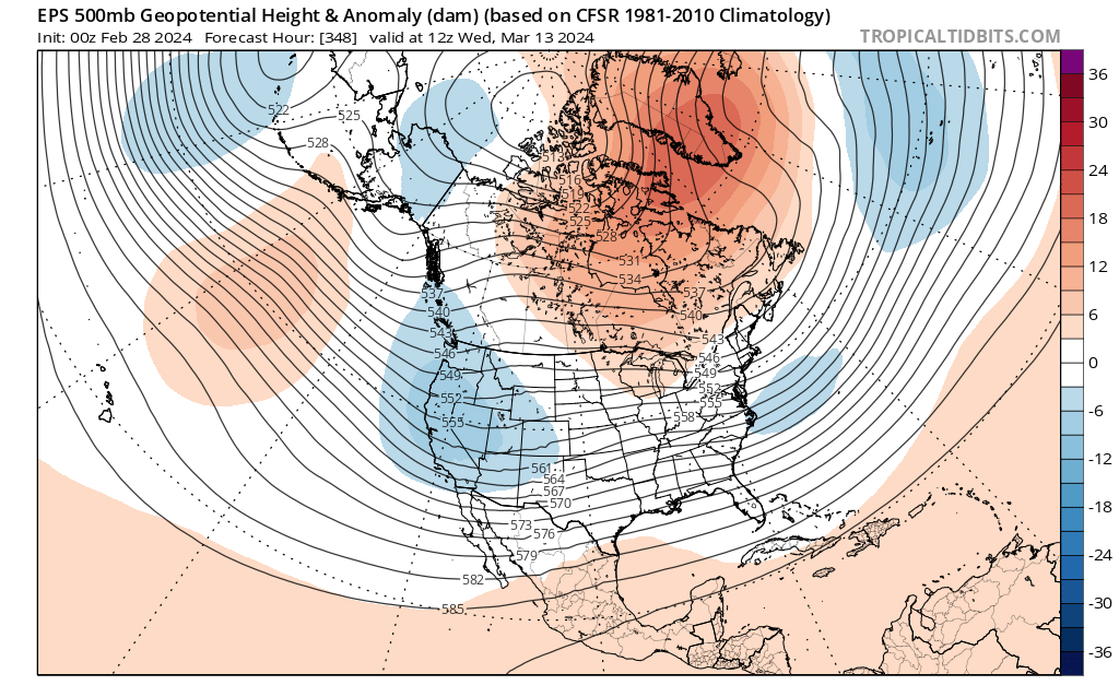
Active, relatively cold pattern to continue toward mid-March
At this moment, the very heavy mountain snow event this weekend appears to be the largest storm imminently on the horizon. But the overall pattern over the Northeastern Pacific will remain potentially quite active, with a continuation of a Gulf of AK ridge/West Coast trough pattern favoring colder though not extremely wet storms during this period. As a result, I’d anticipate a good snowpack-building pattern to continue into mid-March with periods of more widespread (though probably not terribly heavy) rain at lower elevations.
Live YouTube office hour Thu AM to discuss extremely heavy Sierra snow event
Join me live tomorrow (Thursday) at 10am Pacific Time during my latest interactive weather & climate office hours session to discussing the impending Sierra snowstorm!
Discover more from Weather West
Subscribe to get the latest posts sent to your email.