Widespread thunderstorms possible across Southern California Mon/Tues, but considerable uncertainty remains
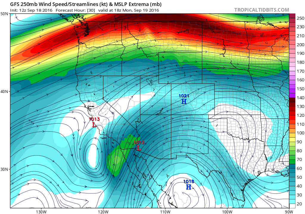
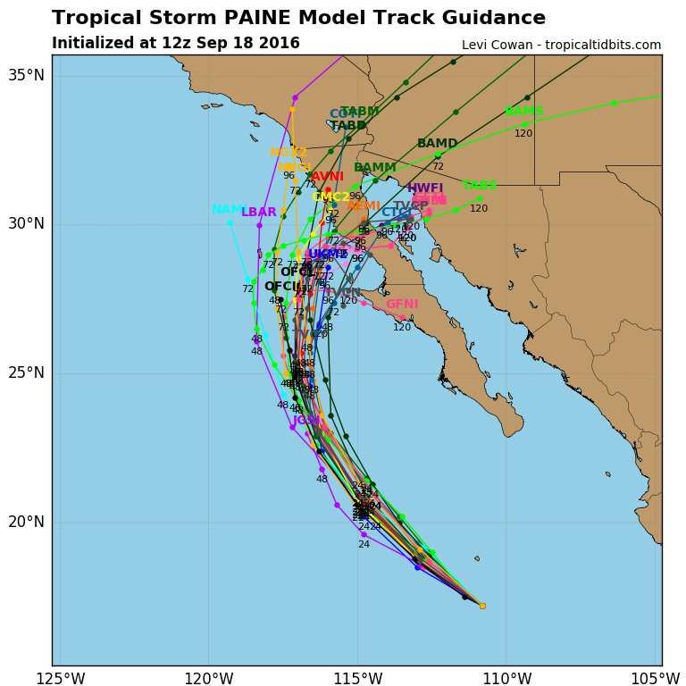
After an unusually quiescent summer across Southern California in 2016 (especially compared to the previous year), a bout of active weather is likely to affect Southern California early this week. A rather complex weather pattern is currently evolving over the far eastern Pacific Ocean south of California, with an upper-level low currently spinning just off the coast and newly-formed Tropical Storm Paine moving northwestward over the ocean parallel to Baja California. Over the next 48 to 72 hours, the upper-level low will approach the the California coastline and entrain tropical moisture emanating from TS Paine–potentially bringing a rather widespread outbreak of thunderstorms to much of Southern California.
A significant amount of uncertainty remains, however. The exact trajectory of the upper low will dictate whether the greatest atmospheric instability–and therefore risk of thunderstorms–remains offshore over the California Bight. The overall dynamical setup still looks pretty favorable for a significant convective event (although perhaps not quite as favorable as it appeared a couple days ago). Strong upper-level diffluence on the east side of the low combined with a modest jet streak, the presence of a few vorticity lobes moving overhead, and increasingly deep tropical moisture, may together be enough to trigger the development of a large mid-level convective cloud deck with embedded thunderstorms. This sort of weather pattern often brings “patchy” thunderstorm activity in this part of the world–meaning that while there’s a good chance that some spots see some significant weather, other places may just see some pretty clouds.
Another important point here is at overall precipitation with this event is actually expected to be rather light–almost universally under a quarter inch and probably less than a tenth of an inch in most places. The potential for widespread lightning without significant precipitation raises the prospect of dry lightning, and attendant fire weather concerns (especially given that this event is occurring following a particularly hot/dry weekend and in the midst of an extreme drought). The National Weather Services offices in Los Angeles and San Diego have issued Fire Weather Watches accordingly. Some risk of dry lightning may extend as far north as the Central Coast and central Sierra Nevada, but the highest risk will likely remain across coastal Southern California.
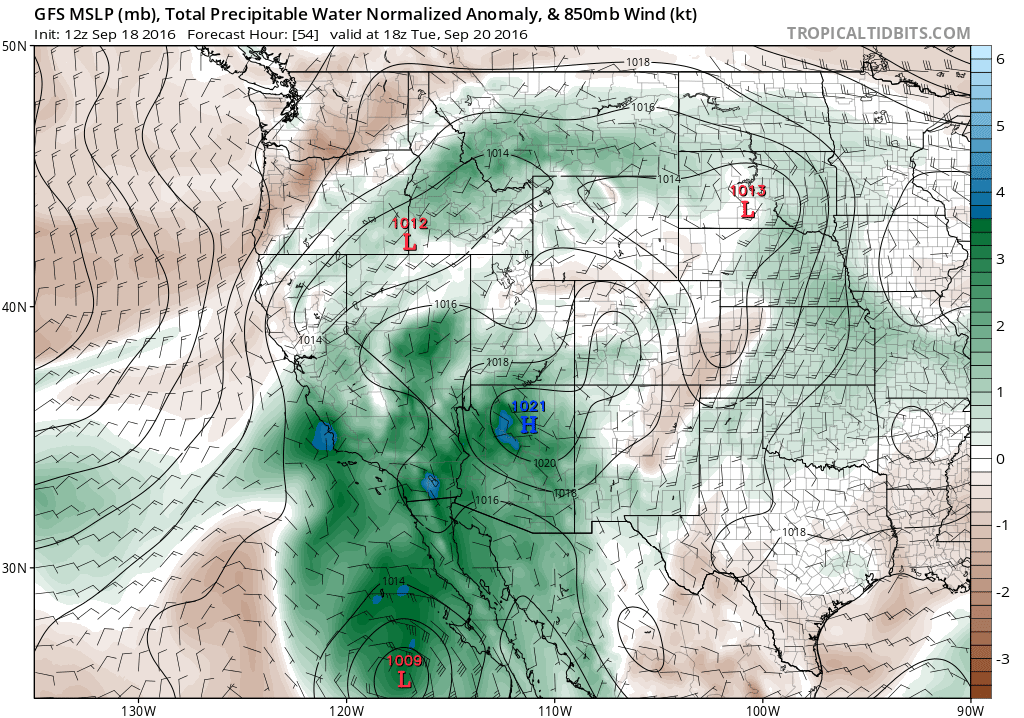
There is some further uncertainty regarding what happens on Wednesday and Thursday, as the remnant circulation center from then-decaying TS Paine lingers. Model forecasts are less aggressive currently than they were a few days ago regarding the progression of remnant moisture/energy into SoCal, so a repeat of the remarkable Hurricane Dolores remnant event last summer is unlikely. Still, there is some potential for a risk of showers and thunderstorms to linger beyond Tuesday across parts of SoCal, especially in the mountains and deserts. It does appear for the moment that the highest likelihood of thunderstorms near the coast will occur with the initial moisture surge on Monday and Tuesday.
“The Blob” returns to the North Pacific, and La Niña is fizzling
There has been much discussion in recent days regarding the return of a broad region of very anomalously warm ocean temperatures to the far northeastern Pacific Ocean. In a spatial sense, this warm anomaly strongly resembles the North Pacific “Blob” which has recurred during several recent winters–often coinciding with anomalously strong and persistent atmospheric high pressure associated with the Ridiculously Resilient Ridge. Indeed, a quick analysis of recent pressure patterns reveals that a region of anomalously high pressure (both at the surface and aloft) is once again present over the North Pacific.
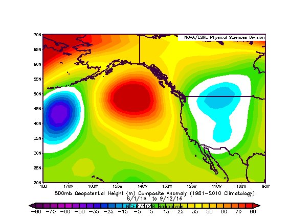
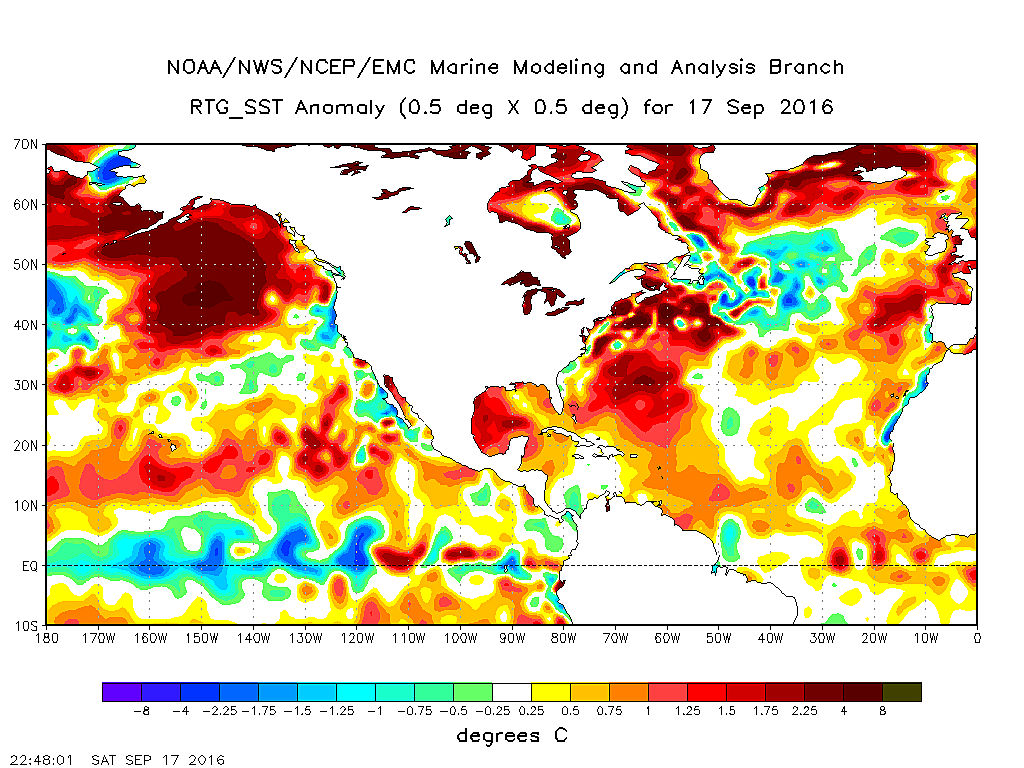
It’s certainly true that the warm ocean “Blob” and the seemingly ever-present “Ridiculously Resilient Ridge” correspond in space and time–and it’s therefore reasonable to hypothesize that they are causally related to one another. But even a strong correlation does not necessarily tell us anything about direction of this relationship–in other words, is the warm ocean causing the atmospheric high pressure, or vice versa?
Disentangling cause and effect can be quite challenging in atmospheric science given the potential for self-reinforcing or self-mitigating “feedbacks” in the Earth system, since in certain situations the ocean can strongly influence the atmosphere above but in others the ocean is primarily responding to atmospheric variations (and sometimes the relationship goes both ways!). In the case of The Blob, there’s a fair bit of evidence that the warm ocean water is actually a secondary consequence of the persistent atmospheric high pressure above it. Since the persistent Triple R suppresses the North Pacific storm track, there are fewer strong wind events to vertically “mix” the warmer upper layers of the ocean with cooler waters from beneath, and the net result is that the surface ocean stays unusually warm. So it does not appear that The Blob is the primary cause of the Ridiculously Resilient Ridge–other Earth system interactions are likely at play (and this remains the subject of ongoing research, including my own). It’s also possible that The Blob, despite not being an initial cause of the Ridge, may indeed be reinforcing the Triple R’s persistence–and if that’s the case there may indeed be implications for the coming winter. But despite a number of media headlines to the contrary, the return of the Blob does not necessarily portend the return of the Triple R.
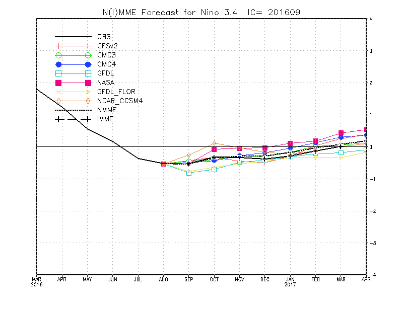
As much as it would be nice to say that the outlook for the coming winter is coming into focus, that’s not yet the case. La Niña appears to be fizzling in the tropical Pacific, and the latest multi-model ensemble forecast suggests that the marginally cool SSTs in the eastern tropical Pacific have already bottomed out. ENSO-neutral conditions are now the most likely outcome for the coming winter–meaning that there’s one less tool in the forecasting toolbox to make predictions regarding California precipitation.
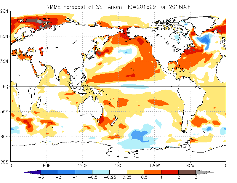
It is interesting to note that the multi-model ensemble does predict the persistence of an unusually warm North Pacific (in somewhat “Blob”-like fashion) through the coming winter months. There has been some suggestion that West Coast ridging may be enhanced once again during the coming winter as well. At the same time, though, these same models have been producing very inconsistent precipitation forecasts for the same period–varying from rather wet over California to quite dry during the first half of the rainy season (forecasts for the latter half of the rainy season, though, have generally been on the dry side–especially in Southern California).
It’s important to realize that multi-month precipitation outlooks are quite challenging in California. This is partly because it only takes a small handful of powerful atmospheric river storms to “make or break” annual precipitation totals across much of the state, and it’s therefore possible to have very dry conditions (and persistent ridging) punctuated by a few brief but intense periods of heavy precipitation that heavily sway the overall average. That’s not a specific prediction for this year, but recent evidence does suggest that increasingly wide swings in California precipitation are likely as the climate warms. For the moment, we’ll just have to wait and see how the Pacific Ocean and model forecasts evolve in the coming months.
Discover more from Weather West
Subscribe to get the latest posts sent to your email.