Remnants of Typhoon Songda to bring powerful Pacific NW storm
Much of the West Coast of North America is about to experience a rather impressive, prolonged period of stormy conditions over the next 7-10 days. Multiple intense and high-impact storms are likely to affect coastal areas from southern British Columbia to the northernmost reaches of California, with more modest rain and wind likely as far south as the Bay Area. As is often the case during autumn storm events, there will be a fairly sharp north-south rainfall gradient across California over the coming week–with the far North Coast potentially seeing upward of a foot of rainfall while the SoCal metros (including Los Angeles and San Diego) receive little if any precipitation.
Minor weather tangent: West Pacific tropical remnants & West Coast storms
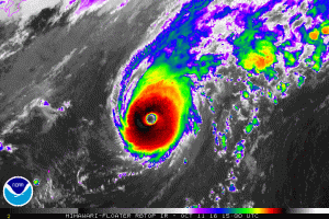
This unusual (but certainly not unprecedented) burst of autumn storminess can largely be attributed to the injection of moisture and energy into the Pacific storm track by present Super Typhoon Songda. Tropical cyclones in the warm West Pacific can occasionally “recurve” from their predominantly east-to-west trajectory, veering northward and then eventually eastward as they approach the active west-to-east storm track region and associated upper-atmospheric jet stream. Such recurving cyclones can affect West Coast weather via one or both of two possible mechanisms–either by strengthening and “extending” the East Asian jet stream further eastward over the North Pacific basin or less commonly by transitioning into a “hybrid” extratropical cyclone and arriving largely intact (but in weaker form) in the Pacific Northwest. In the present case, it appears that Songda will do a little of both–strengthening the overall storm track and persisting as a powerful remnant surface low as it treks eastward across the Pacific.
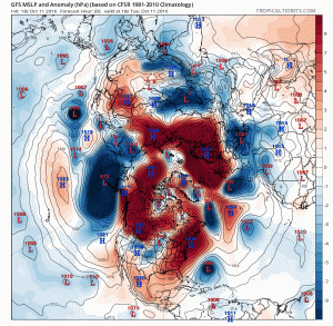
It might be a bit surprising to learn that former West Pacific typhoons can have such a profound influence upon West Coast weather. But history suggests that there is a relatively narrow window in autumn–mostly during the month of October–when a rare confluence of events can produce truly extreme storm conditions. One of the most significant California events of this kind in recent memory occurred in October 2009, when the remnants of Typhoon Melor re-intensified as an extratropical cyclone off the coast of Northern California and brought extraordinary rainfall and damaging winds to a wide region. But even the 2009 event pales in comparison to the incredibly destructive Columbus Day Storm of 1962, which drew its energy from the remnants of former Typhoon Freda. The so-called “Storm King” brought winds well in excess of 120 mph to much of coastal Oregon and near-hurricane force winds from the California border to Vancouver, BC–an event that would be even more disastrous today, given the large increase in population and human infrastructure that has occurred in that region since 1962. Fortunately, as disruptive as the upcoming event may be in Washington and Oregon, nothing even close to the magnitude of the 1962 event is anticipated.
California impacts: Very wet and rather windy north; SoCal misses out (again)
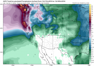
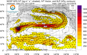
Northern California will probably see some hefty rainfall accumulations over the next 7 days as a series of storms take aim at the west coast. While the heaviest rainfall and strongest winds with the upcoming storm series will be focused at the Pacific Northwest, the northern third of California will experience periods of intense precipitation and strong winds through the next 5-7 days. In fact, a very impressive atmospheric river associated with the remnant moisture plume from Songda will extend clear across the Pacific Ocean by Thursday. Recent atmospheric model forecasts suggest that the amount of atmospheric water vapor transport during that portion of the event could exceed record values for the month of October over most of NorCal–a striking statistic, although it’s worth noting that October records are considerably lower than those during our peak rainy season from November-March. Moderate to heavy rainfall may occur as far south as the Bay Area, and light rainfall somewhat further south than that. There is a chance of some light rain in southern California, but at the moment it does not appear that areas from Los Angeles southward will see appreciable rainfall.
Winds will be strong and gusty in NorCal, especially along the North Coast. But, for the most part, the more damaging conditions will likely remain north over Oregon and Washington–where gusts in excess of 70-80 mph are entirely possible.
Rainfall of the magnitude that is expected to fall along the North Coast could lead to some flooding problems, especially since the first round of intense rainfall will be followed by another later in the weekend. Further south, it’s likely that even relatively heavy precipitation will be absorbed by the extremely dry soils without too much trouble. “Season ending” rainfall–enough to dramatically reduce wildfire risk–will likely occur this week over most of Northern California. Rainfall in central California will probably be enough to temporarily reduce fire risk, although the southern 2/3 of the state likely won’t see season-ending rains in the next 10 days. All told, this series of early-season systems will likely bring more benefits than hazards to drought-stricken California.
Latest thoughts on the coming winter: another north-south split?
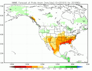
Despite the promising start to the rainy season this week across NorCal, longer-term signs for the coming winter are decidedly mixed. La Niña conditions are no longer officially expected to occur, but the East Pacific nonetheless remains marginally cool, and a vast swath of the North Pacific from the western tropics to the northeastern extratropics remains exceptionally warm. The most recent forecast from the North American Multi-Model Ensemble (NMME) is suggesting that persistent West Coast ridging may return this winter–but not necessarily to the total impediment of NorCal precipitation. Interestingly, the multi-model ensemble is hinting that last year’s north-south wet-dry split could continue, along with relatively warm conditions–with SoCal remaining fairly dry and NorCal remaining a bit more of a wildcard (could be wet or dry, depending on how persistent the ridging ultimately becomes). With the ever-present caveat that accurate seasonal forecasts for the West Coast remain elusive, it will be interesting to see if the general spatial patterns showing up in these long-range model simulations ultimately come to pass. Stay tuned!
Discover more from Weather West
Subscribe to get the latest posts sent to your email.