Following a whiplash transition from record warmth to very heavy mountain snowfall in California, yet another swing back toward anomalous warmth (first damp, then dry)
A remarkable snowy interlude during what has thus far been a record warm winter: Disruptive, and even deadly, in the Sierra Nevada
Last week’s snowfall in the Sierra Nevada–and also at much lower elevations, for the first time this season, into even the lower foothills and Coast Ranges–marked a dramatic shift from a nearly 40-day stretch of dry and unusually warm conditions. Moreover: this sudden flip occurred during what is still the warmest winter on record for most the Western U.S., including many of California’s mountain areas. It brought widespread travel disruptions, especially for those caught unprepared, with all major mountain highways in the Sierra Nevada closing for extended periods.
But the most serious and unexpectedly tragic consequence of this rapid weather pattern shift was the avalanche near Castle Peak (not too far from Donner Summit, and just west of Truckee) that claimed the lives of nine backcountry skiers–making not only the deadliest avalanche in contemporary California history, but also the single deadliest avalanche in the United States since 1981. This event was facilitated by a combination of well-understood, and well-predicted, antecedent risk factors: the prevalence of a weak and icy snow layer due to warm temperatures and freeze/thaw cycles in the weeks leading up to the event, and the subsequent arrival of an intense, blizzard-like snowstorm that dropped as much as 4-6 feet of snow on the nearby peaks over just a 2-3 day period. The combination of a weak base layer and very intense “snow loading” during the storm itself led to an exceptionally high risk of snow slab failures, and one of these ultimately occurred in the path of travel of the ski group and their guides. Much has already been said in the wake of the tragedy; I have no desire to speculate beyond what has been publicly reported here. But I will reiterate this important fact: the remarkable and rapid shift to very heavy Sierra Nevada snowfall, and the resultant very high backcountry avalanche risk, was very well predicted and had been communicated in advance by both the National Weather Service and the Sierra Avalanche Center (which had issued early Avalanche Watches and later an Avalanche Warning as the system approached). This recently published piece in SF Gate does a good job breaking down the timeline and details, and also framing some of the bigger questions that will inevitably be pondered in the aftermath.
Snowfall, while not record-breaking as some have claimed, did make into some top-10 lists in a few orographically-favored Sierra western slope locations. The Central Sierra Snow Lab logged its 10th snowiest 24 hour period on record during this event, as well as its 9th snowiest 72-hour period–but the most notable statistic is the 5-day accumulation of 111 inches, which marks the 3rd snowiest such period on record. The CSSL benefited not only from excellent orographic forcing (i.e., lifting of air by topography) during this event but also from near-ideal alignment of the recurrent heavy precipitation along the Interstate 80 corridor as well as convective enhancement (there was even some Sierra thundersnow at times locally–not surprising given that the same storm brought severe thunderstorms with damaging wind gusts to portions of SoCal).
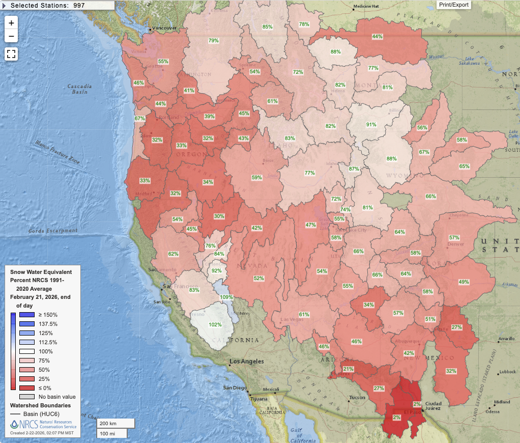
As one might expect, this heavy Sierra snowfall bolstered central and southern Sierra snowpack quite substantially; many high elevation observing sites are now at near to above-average snow water equivalent (SWE) levels for the time of year. Many lower elevation sites, however, as well as those in the Northern Sierra and Shasta Mountains, remain below average even following last week’s accumulations. Overall, though, California’s water situation looks pretty solid at this point given the very wet start to the season in central and southern CA followed by this mid-winter top-up of critical central and southern Sierra snow water.
It’s a very different story, though, nearly everywhere else in the West. Last week’s snow deluge centered pretty heavily on California; while snow also fell in the Cascades and Rockies to the east, amounts were not nearly so impressive. In fact, while overall snowpack conditions did improve slightly across most of the West, the only place where snowpack came even close to average was in California and across a portion of the northern Rockies. Extremely low snow conditions persist in the Pacific Northwest, Great Basin, and central/southern Rockies–where many locations remain, even after last week’s snowfall, near or at record low SWE. The Colorado River Basin remains in trouble; Upper Basin SWE as of yesterday (again, after all the snow) are still at period-of-record lows (since the early 1980s in the NRCS dataset). And dry/warm conditions are set to return to much of the West in the coming days…as discussed below.
An exceptionally warm and moist atmospheric river will affect NorCal and the PacNW this week–but will bring largely (and thankfully) unexceptional impacts despite some flood risk
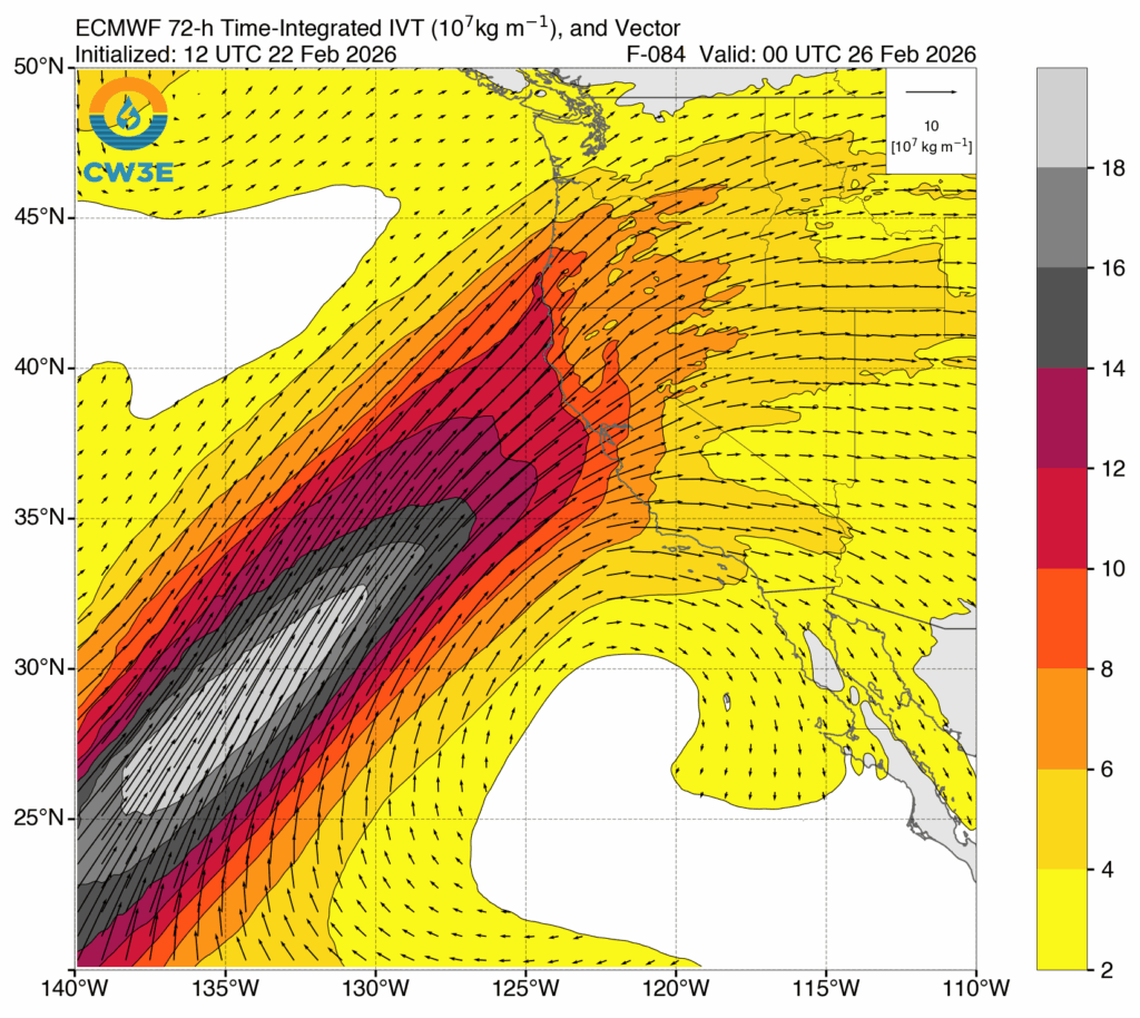
There has been a bit of social media buzz surrounding a very warm, and very moist, atmospheric river that will take aim at California and the broader West Coast over the next few days. And, in a literal sense, this is true–a remarkably warm and moist plume of air, with origins in the subtropics, is indeed aimed directly at Northern California. And it will produce widespread rain atop recent heavy snowpack in the mountains, leading to a rain-on-snow event across essentially all of Northern California’s mountainous areas.
All of that might sound pretty alarming, at face value. And there are some plots, including the “scary-looking” time-integrated vapor transport plot above, which might understandably conjure flood fears. Yet while there will be some flood risk across portions of NorCal with this event, it is likely to be somewhat localized and rather modest in magnitude. In fact, right now, it generally appears that most of the upcoming flood risk will be on the “nuisance to minor” end of the scale versus something worse. It’s possible a couple of isolated spots could see more moderate flooding, but it’s pretty clear at this point that widespread or severe flooding is unlikely during this event. So what’s really going on here?
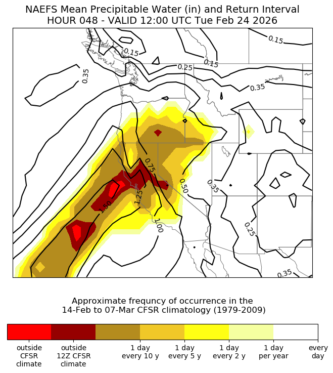
Well, as indicated above in the plot from NOAA’s Situational Awareness tool, the absolute amount of water vapor in the atmosphere will indeed be at near-record levels for the time of year across California and adjacent coastal waters. And it is also true that the airmass will be exceptionally warm–so much so that snow levels will be above 10,000 feet nearly everywhere, and at times over 12,000 feet. So nearly all precipitation, event on many mountain peaks and passes, will fall as rain.
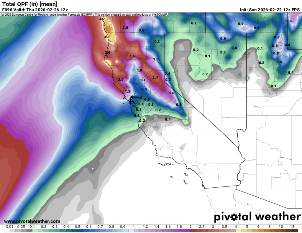
But there are two separate flood risk mitigating factors at play.
First, the atmospheric river itself, while extremely moist and warm, will not be associated with strong synoptic support–meaning that it will be almost entirely dependent on orographic lifting to generate the upward motion required for precipitation formation. There’s no strong cold front, any other boundary; there’s no nearby surface low, and upper-level jet support will also be lacking. Thus, precipitation will be light outside of the windward slopes of the mountains, and even there it will be only moderate. 1-3 inches could fall, which is substantial in the rain-on-snow context, but far from extreme. Additionally, this rain will fall fairly gradually over several days; no intense downpours or thunderstorms are expected.
Second, thick snowpacks (like the one now in place across the higher Sierra) actually have a quite substantial capacity to absorb rain that falls into them, up to a point. In fact, it’s pretty likely most of this rain will be absorbed (and refrozen within) the existing snowpack anywhere where more than 2-4 feet of snow remains on the ground–at least temporarily increasing snowpack water storage in these areas and limiting subsequent runoff. Meanwhile, at lower elevations where snowpack is much thinner and thus more susceptible to melting from falling rain, the amount of snow water storage is considerably lower and also rainfall accumulations are expected to be even more modest.
So, overall, this very warm/moist but dynamically weak AR will likely result in a widespread, but relatively modest-in-impact, rain-on-snow event in NorCal. There will be some flood risk in two specific settings: 1) Along the North Coast, where the heaviest rain will fall and where some decent lower-elevation snowpack currently exists that is susceptible to melting during this event (and, similarly, perhaps in the lower foothills of the central/northern Sierra); and 2) in or near the larger Sierra Nevada towns (like Truckee and South Lake Tahoe) that were buried with multiple feet of snow last week and where even modest amounts of rainwater percolating through the snowpack could cause urban/street flooding due to clogged storm drains and culverts. I would not expect any of this flooding to be sudden or severe, but any level of flooding can be disruptive if it happens in your neighborhood!
We are fortunate that this exceptionally warm and moist plume is not going to synch up with a stronger parent storm system; had that occurred, it could have produced a serious flood scenario for NorCal this week. As it stands now, though, this event looks like it will be fairly unremarkable in most major NorCal urban areas and perhaps modestly consequential in the more localized minor-moderate flood risk regions noted above. Nearly the entire state, however, will become increasingly warm and “muggy” this week as moist subtropical air pervades even areas that will see little or no precipitation from this event.
Finally: this widespread rain-on-snow event will again greatly increase the risk of backcountry avalanche activity in the coming days (including wet slab avalanches, which is a different potential hazard than last week). Please be smart out there.
Robust and sustained warming and drying trend will begin first in SoCal, then spread to NorCal–with spring-like temperatures by late Feb
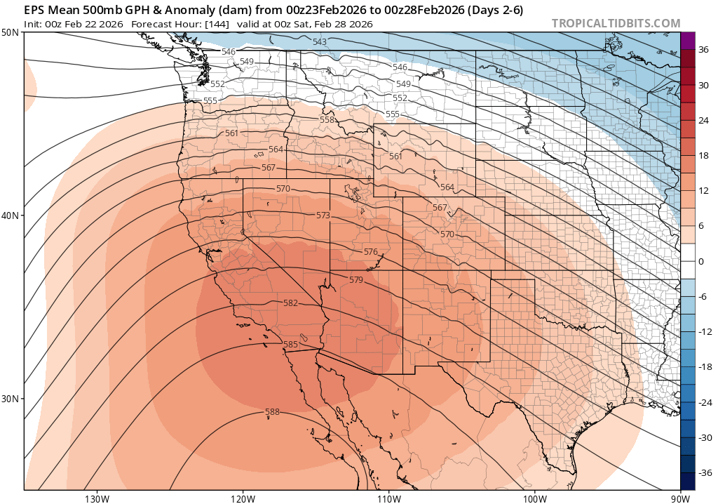
There remains some uncertainty regarding how long the weaker vestiges of the very warm atmospheric river may linger in NorCal; some runs of the ECMWF ensemble suggest continued very light warm rainfall will be possible into next weekend, though others dry out before that. Either way, the general trend will be toward much drier and warmer conditions once again. SoCal will bask in well above average temperatures reaching springlike levels once again, well into the 70s and perhaps 80s. NorCal, too, will see coastal and valley temperatures well into the 60s and even some 70s; mountain snowpack will begin to melt in earnest once again as “warm and damp” transitions gradually toward “warm and dry” during this period.
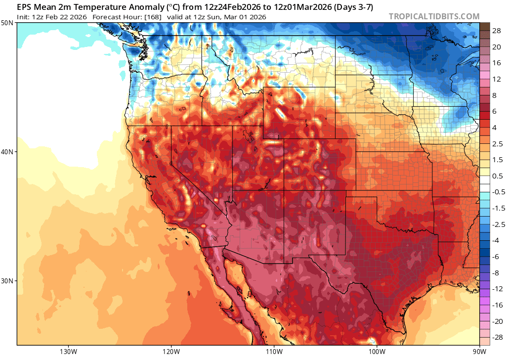
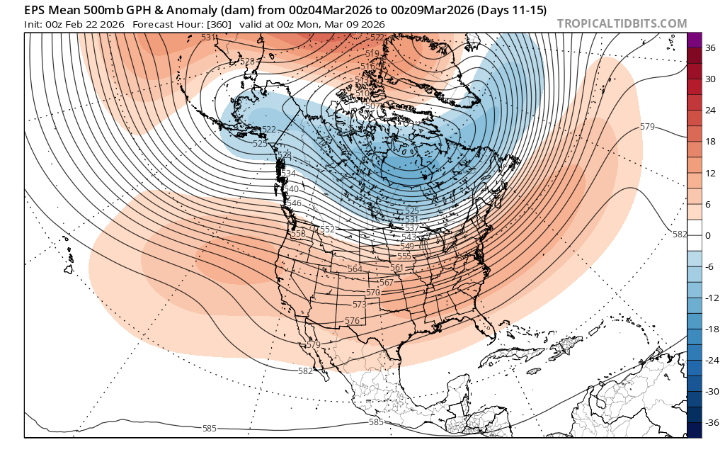
As is always the case this time of year, there are a range of outcomes that remain possible as we head into March. Right now, though, the single most likely outcome (which is supported pretty strongly by multi-model averages) is a broad ridging pattern extending across the entire continental U.S.–potentially bringing a much quieter weather period in the coming weeks versus the very active pattern that has occurred since late January through the present. This is not great news for the ongoing severe snow drought across the Intermountain West, and I would expect SWE to once again decrease rapidly versus seasonal norms during this period across essentially the entire West. It is worth re-emphasizing, though, that one benefit of the remarkable whiplash experienced in California recently is that the state has exited its multi-year drought for the time being; in fact, for the moment, it’s the only Western U.S. state not experiencing acute drought as of this month.
YouTube livestream on Monday, Feb 23 to discuss recent changes in western snowpack, very warm atmospheric river event and broader context, and warmer/drier pattern to come
See you there, and bring your questions!