Despite cool and occasionally unsettled conditions in NorCal, unusually dry conditions to persist into March
After late Jan atmospheric river deluge, a return to drier than average conditions
The main weather excitement of the season thus far was certainly the major late January atmospheric event that was the focus of my last blog post. Despite missing some the details during the early portion of the event (winds were stronger and precipitation less intense than originally predicted), the storm largely evolved as expected–stalling along the Central Coast and bringing very heavy double-digit rainfall totals there, as well as extremely heavy snowfall throughout the Sierra Nevada (on the order of 3-8 *feet* in many places). The Santa Cruz Mountains, where there was initially great concern regarding the potential for destructive debris flows following large and severe wildfire activity last summer–were largely spared any significant problems. More substantial impacts did occur in Monterey County and the adjacent Central Valley, where widespread flooding and significant debris flows occurred near wildfire burn areas. Among other infrastructure issues, an iconic stretch of Highway 1 along the Big Sur coast was (once again) washed into the ocean by one such debris flow.

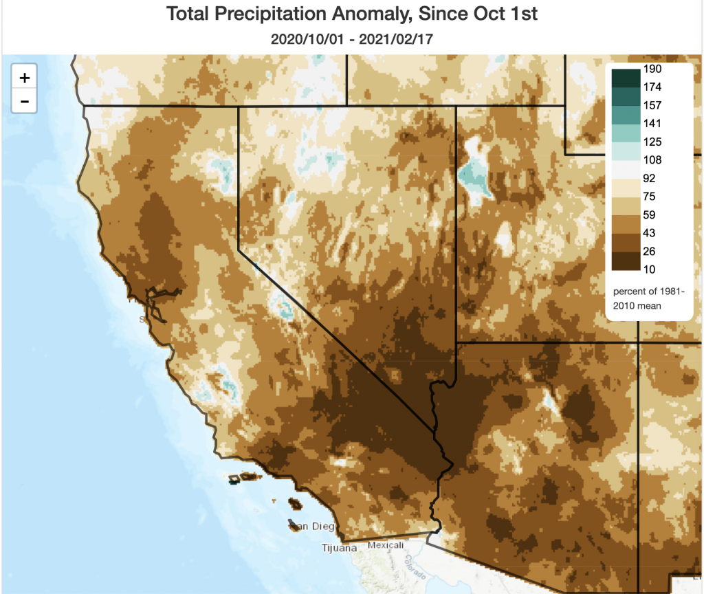
In some parts of the state, however, this single storm event brought essentially the only substantial rainfall of the entire season to date. As such, nearly all of California remains far behind average in the precipitation department for the Water Year (Oct 1) to date (with some very localized exceptions where seasonal totals are near average around where the AR stalled in January). Sierra Nevada snowpack has fallen slightly from its peak around 70% of average in late Jan to around 65% of average as of today–not terrible, but not great, either. The 2020-2021 season has, unfortunately, shaped up very much as seasonal predictive models suggested it would–with much drier than average conditions as of mid-February essentially statewide.
Cool and occasionally unsettled across NorCal, but much drier than average statewide

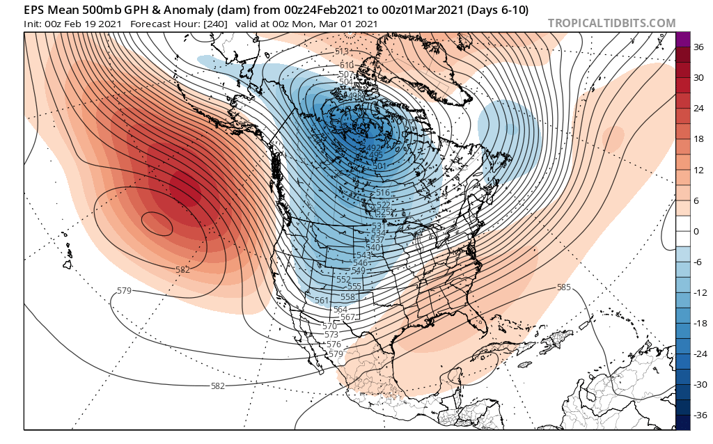
A strong and persistent ridge will build in the Gulf of Alaska in the coming days, leaving California in relatively cool but also relatively dry northerly or northwesterly flow. Weak cold systems will repeatedly brush NorCal over the next 10+ days–bringing a chance of occasional coastal showers and slightly more substantial mountain snowfall (down to 2,500 to 3,000 feet at times) at times. But these systems won’t be nearly enough to keep pace with average precipitation over the next couple of weeks during what is typically the wettest time of the year in California. And even less precipitation is expected across SoCal–there is at least a chance that some areas could see a complete February shut-out (much as portions of NorCal did last season). This could also be a windy pattern at times, with fairly strong surface pressure gradients arising from multiple “inside slider”-type systems over the Great Basin.
This is not a completely dry pattern (known as a “dirty ridge” scenario by some local meteorologists!), and there is a slight chance that a stronger/colder system could eventually dig southward a bit farther to the west than currently indicated–bringing more widespread cold showers to the state at some point during the next 10 days or so. But at the moment, this appears to be a pretty dry (if relatively cool) pattern for most of California.
Seasonal outlook: continued dry into the spring, unfortunately
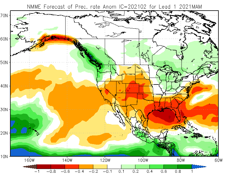
I wish I had better news to report about March and beyond, but…alas. The most likely outcome for March–and the rest of spring–are continued drier-than average conditions across most of California. There continues to be an unusually strong signal in the seasonal predictive models (which have done a good job so far this season in CA) that the storm track will be weaker and shifted northward across a good portion of the United States. The spatial pattern continues to resemble a canonical La Nina distribution, despite the fact that cool SSTs in the eastern tropical Pacific have subsided since their autumn peak. This portends a potentially very dry spring across most of the interior West, as well–which could portend another severe fire season in many areas already experiencing severe to extreme drought. I really do hope this outlook improves, but right now it looks increasingly likely that nearly the entire West outside the Pacific NW will be dealing with widespread severe drought conditions heading into summer.

And lastly…some thoughts on recent extreme weather in Texas and beyond
Texas and surrounding states just endured a particularly extreme Arctic outbreak, which triggered widespread failures of the regional electrical grid. Cascading impacts led to widespread and deadly societal disruption, with long-duration power, water, and telecommunications outages–leading to a humanitarian crisis. Given much public interest (and mis-information!), I wrote a long-ish Twitter thread on the underlying atmospheric processes that caused this event, why such an event is essentially impossible in California, and the broader context of extreme winter cold events in a warming climate. If you’re interested, check out the full thread below!