Remarkably wet winter so far in California…and more storms to come.
After years of drought, California finally sees widespread relief
After so many blog posts over the past few years on the progress of California’s record-breaking, multi-year drought, it’s refreshing to finally be able to talk about the widespread drought-relieving rain and snow that has fallen throughout the state in recent weeks. It will probably come as no surprise to anyone living in California–especially in northern and central portions of the state–that December and January 2016-2017 were exceptionally wet months, featuring a very active Pacific storm track and a nearly continuous series of storms. While many of these precipitation events have still been aimed to the north of Los Angeles, Southern California has finally received a couple of very significant rainfall events, including a late January storm which brought widespread urban flooding and even some severe thunderstorms, setting several rainfall records. Things have temporarily calmed down over the past week, giving sodden parts of the state time to dry out a bit (and for rivers to recede). Meanwhile, in the high Sierra Nevada, state highway crews are still digging out from the 10-20+ feet of snow that fell in some areas earlier in the month. Needless to say: it is quite clear that the “Ridiculously Resilient Ridge” has not returned this year.
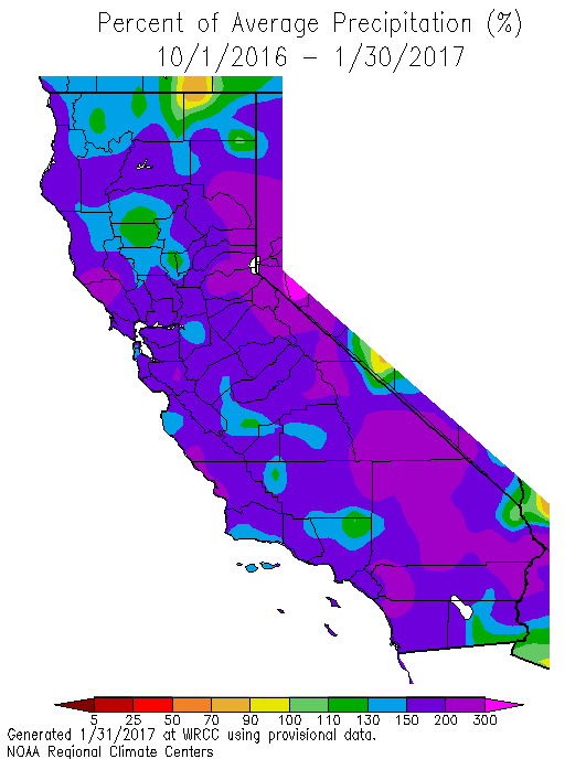
Where do we stand in the history books? Well, it has not (quite) been record wet across California in recent months, although it has come close in many places and rain/snow statistics have nonetheless been extremely impressive. Most of the state current sits at or above 150% of average for the Water Year to date, and some spots are well over 200%. This marks the wettest first half of the rainy season in many years, and perhaps the best news is that much of this water has actually fallen in frozen form as snow in the Sierra Nevada. In fact, the current snow water equivalent in California is the highest in 22 years–since the memorable storms during the winter of 1995.
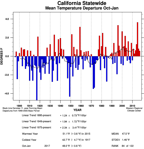
It’s interesting to note, however, that this prodigious mountain snowfall has not occurred because it has been particularly cold. In fact, data show that temperatures to date have–for the seventh consecutive winter–been above average, though not by as wide a margin as during recent record warm winters. This is evidenced by the rather astonishing fact that snowpack water equivalent on January 1, 2017 was only 64% of average for the date, but by February 1, 2017 had shot up to 177% of average. It’s pretty clear that the huge influx of Pacific moisture in recent weeks, combined with “just cold enough” temperatures, was the real driver behind this fortuitous snowpack turnaround. This recent experience is interesting in light of expected future changes to Sierra Nevada snowpack as California’s climate continues to warm. Big snowfalls like the January 2017 event will still sometimes occur even in a much warmer climate, but future storms that might historically have been “just cold enough” will instead be “not quite cold enough,” and associated precipitation will be much more likely to fall as rain, rather than snow.
“Is the California drought over?”
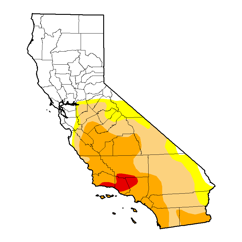
It’s a question I have been receiving quite frequently over the past few weeks, so I thought it would be worth addressing here. One place to turn to for a quick answer is the Drought Monitor, which would suggest that the drought across much of Northern California is indeed over, but that the drought in much of Southern California remains severe. Indeed, from a “surface water” perspective (i.e. that relating to the water present in rivers, lakes, streams, and man-made reservoirs) the Northern California drought is essentially over, while it lingers at a reduced intensity in the south. But there are multiple ways to define drought–and if one extends the definition to include the state of groundwater aquifers and the health of ecosystems, the long-term impacts of California’s severe drought linger across nearly the entire state. It will be interesting to see whether wet conditions continue for the rest of the rainy season, and whether late winter and spring temperatures will be cool enough to sustain the impressive Sierra Nevada snowpack into the early summer months.
New series of storms to affect mainly Northern California over next 10 days
After a roughly week-long break in storm activity, the Pacific jet stream will once again shift back toward California over the next 24 hours. A series of storm systems will move across California beginning on Thursday, bringing yet more significant rainfall and mountain snowfall to the northern half of the state. Rainfall in Southern California will probably stay on the light side, although everyone should see at least some precipitation.
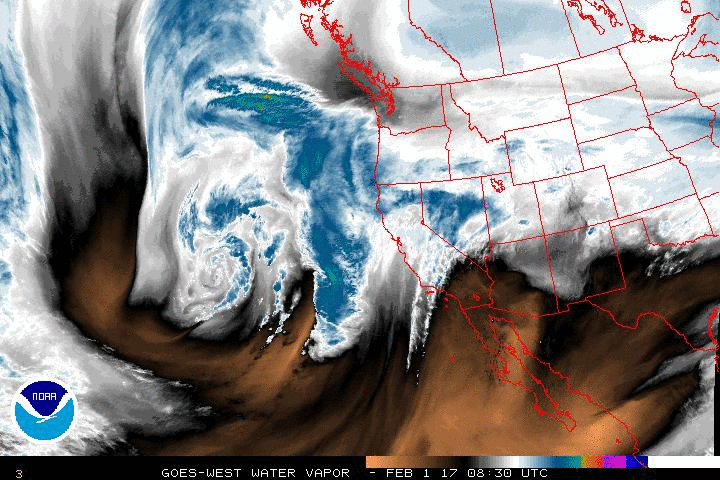
The first (and rather photogenic) storm has a fairly respectable subtropical moisture tap, although the relative lack of storm dynamics most likely means this will not be an especially intense storm. Instead, steady but substantial rainfall and mountain snowfall will occur across the northern 2/3 of the state and perhaps be accompanied by some gusty winds and/or isolated thunderstorms. In other words: this system will probably bring yet more beneficial water to California without causing any major problems.
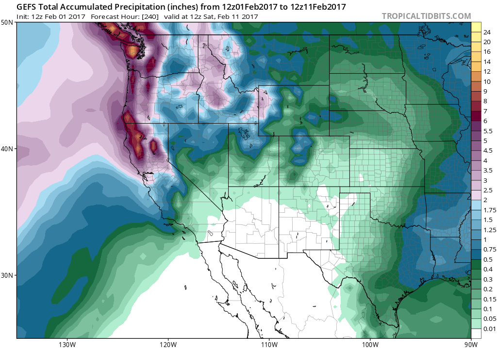
There is some inter-model disagreement regarding the magnitude and timing of storms thereafter, although there is increasing agreement that a second storm due in late in the weekend or early next week could bring some heavier precipitation to NorCal and perhaps generate some flooding issues once again depending upon how fast it moves through. Later next week, models are hinting at the potential for a very moist but dynamically unimpressive atmospheric river–the kind of event that can bring very heavy precipitation in the mountains and but rather unimpressive totals at lower elevations. One reason to watch: if the storm is warm enough, and snow levels high enough, there could be some concern regarding snowmelt runoff. But at the moment, it’s still to early to say. All in all, however, it does appear that a relatively active weather pattern will continue in early February.
Remarkably wet winter so far in California…and more storms to come. Read More »