A remarkably wet and active January so far, especially in the north

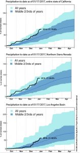
A very wet and stormy period over the past month in California has brought about a dramatic reversal in fortunes in many drought-stricken regions. A series of very moist “atmospheric river” systems brought copious precipitation–in some of the typically wet mountain regions, liquid precipitation has been measured in feet. Widespread flooding of streams and smaller rivers occurred, and the Yolo Bypass on the Sacramento River has been opened for the first time in years. Numerous highway closures took place due to flooding and mudslides, and there have been several levee breaches (although so far impacts of these breaches have thus far been relatively minor).
After a couple of bouts of very warm rains, even at very high elevations, the most recent storm systems have been associated with a much colder modified Arctic airmass. The combination of cold temperatures and and an active storm track brought a tremendous amount of snowfall to virtually all mountain areas of northern and central California (at the highest mountain peaks, as much as 10-20 feet of snow!). In some places, especially along the crest of the Sierra Nevada, the last storm in this series brought extreme and crippling blizzard conditions. Parts of the Lake Tahoe region are still digging out after many feet of snow and nearly hurricane-force winds brought widespread disruptions to the power grid and transportation infrastructure.
And this is why the view from the @MammothMountain Summit Cam was blocked for a few days. 19ft+ of snow. Thanks for the shovel! pic.twitter.com/mG2qFETrmv
— MammothMountain (@MammothMountain) January 13, 2017
Rainfall–and, especially, snowfall–of this magnitude has not been seen in California since before the start of our severe multi-year drought. Unsurprisingly, this recent precipitation has brought considerable drought relief to the northern two thirds of the state. In fact: from a surface water perspective (i.e., relating to the water present in rivers, lakes, and man-made reservoirs), the drought may effectively be over across much of Northern California. Two major caveats to consider: severe to extreme drought conditions persist across much of Southern California, and even in northern California groundwater aquifers remain severely depleted after years of record warmth and dryness. Still, it has been a very long time indeed since Sierra Nevada snowpack was well above average, as it is today. And on a statewide basis, 2016-2017 is actually tracking pretty close to the wettest year on record so far (though conditions have been less anomalously wet in the south). All in all, I think it’s fair to say that there is finally some good news to be had on the California drought front.
Three strong storms to affect California this week
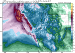
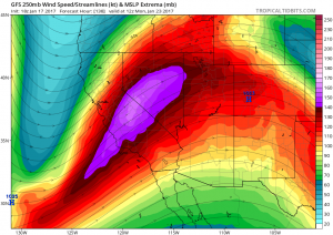
Yet more precipitation is on the way to California. A series of three strong storms are set to sweep across the state beginning Wednesday and continuing through next Monday, dropping widespread heavy precipitation and bringing strong winds to nearly the entire state. The upcoming storms will be fairly different in character from those which brought flooding to California last week. Instead of featuring very warm, moist, and slow-moving plumes of moisture associated with a “classic” atmospheric river, the storms this week will instead be fast-moving, relatively cold, and associated with a powerful Pacific jet stream.

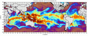
The main plume of moisture with storm #1 (Wednesday)–which stretches across the entire Pacific Ocean westward to the Philippines–will be directed primarily into the Pacific Northwest and north of California (bringing a nasty ice storm to Portland, Oregon). A burst of widespread rain and wind will still be likely with storm #1 across most of California, but it will not be particularly long-lived or excessive.

Storm #2 (Friday) looks stronger, as a surface low may try to develop at a lower latitude along the north side of the powerful Pacific jet extension. Impacts will probably be elevated especially in Southern California with storm #2, as strong jet dynamics will combine with a strong cold front to bring high rainfall rates and gusty winds. Given favorable large-scale dynamics and cold air aloft, thunderstorms may occur with this system, especially south of the Bay Area. Northern California will likely be able to handle precipitation of this magnitude with relatively minor hydrological concerns, but more significant flash flooding is possible in parts of SoCal given greater susceptibility and the possibility of convective rainfall bursts.
Greatest impacts likely in Southern California; uncertainty regarding storm #3

Storm #3 (Sunday-Monday) has consistently appeared likely to be the strongest in the series, but the location of greatest severity is still fairly uncertain. As recently as yesterday evening, all the global models were in agreement that a very strong storm would affect Southern California on Sunday, bringing widespread intense rainfall and strong winds. Today’s model runs have backed off on this possibility, though they still suggest a high likelihood of a significant SoCal storm (especially the ECMWF). The primary reason for this uncertainty: the very favorable structure of the wavy jet stream off the West Coast will allow a very deep surface low to develop offshore, potentially altering the overall flow pattern enough to redirect much of the storm’s energy across the Pacific Northwest instead of SoCal. It remains to be seen how this actually pans out, and storm #3 still has the potential to be highly consequential from a hydrological perspective given the antecedent wetness. Additional thunderstorm activity is possible statewide, as well. One additional consideration with the Sunday storm is that the new “strong surface low” solution may bring some very strong winds to the North Coast of California.
Very heavy snowfall is expected once again across all of California’s mountains, likely measured in feet. Snowfall of this magnitude will have a particularly high impact in the Southern California mountains, which have not experienced very heavy snowfall in quite some time.
More prolonged dry spell starting at end of January
After storm #3 moves out, it does appear that all of California will experience a fairly prolonged drying trend as a ridge builds along the West Coast for the start of February. In the short term, that’s probably good news: after a week of renewed storminess, California will need some time for rivers to recede once again.
As always, I’ll continue to provide micro-updates (particularly regarding the uncertain storm #3) on Twitter.
Discover more from Weather West
Subscribe to get the latest posts sent to your email.