Extraordinary and prolonged March heatwave to break records and decimate mountain snowpack across U.S. Southwest, including much of California
“Winter” 2025-2026 warmest on record across most of Western U.S., including SoCal & Sierra Nevada
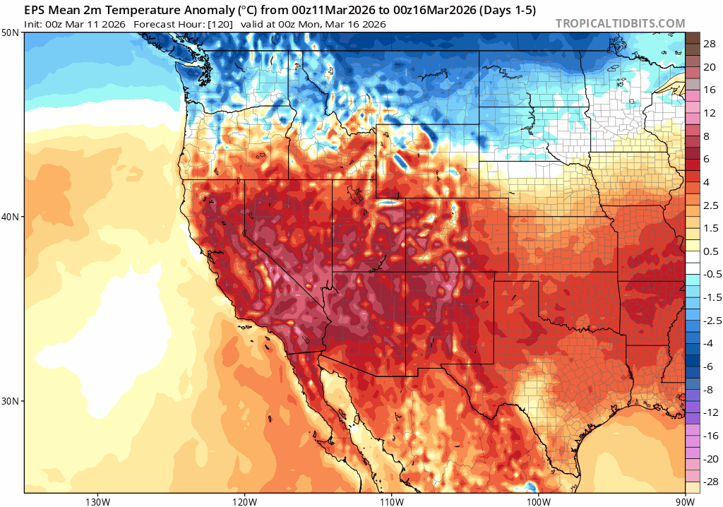
Well, now it’s official: Winter (Dec-Feb) 2025-2026 was the warmest on record across the majority of the American West, and a top-3 warmest winter nearly everywhere that it didn’t quite cinch the record. That includes nearly all of the Colorado River Basin, the Rocky Mountains as a whole, southern California (including all the major metro areas), and much of the Sierra Nevada. Stubborn tule fog in California’s Central Valley under an extremely persistent ridge and following early-season rainfall is the only thing that kept California, on a statewide basis, from breaking the previous all-time winter temperature record set in 2015–and thus 2026 came in at a virtual statistical tie with 2015 on a statewide basis. Notably, most of California’s mountain areas and highly populated southern coastal plain were indeed singularly record warm.
And all that hype about the cold Arctic outbreaks in the Eastern U.S.? Well, there were certainly some very cold periods–as well as some high impact blizzards and ice storms that affected millions. But ultimately, Winter 2025-2026 ended up substantially warmer than even the recent climate-warmed average across about 2/3 of the contiguous U.S.–and even the coldest portions of the East ended up seeing a winter that was (at its coldest) “slightly below” the 20th century average (a “top 30-50 coldest” winter in some of the colder places). So when folks complain that all they hear about is record warmth (“Why do you never talk about the record cold?”)–well, this is why! Record cold has become a truly rare condition, whereas record warmth is now occurring with remarkable and disconcerting frequency.
Exceptionally anomalous and likely record-shattering long-duration March heatwave imminent across U.S. Southwest; will arrive in two distinct waves over next 7-10+ days
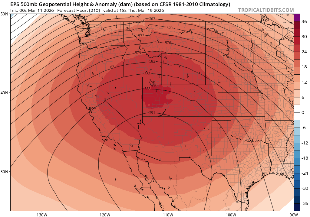
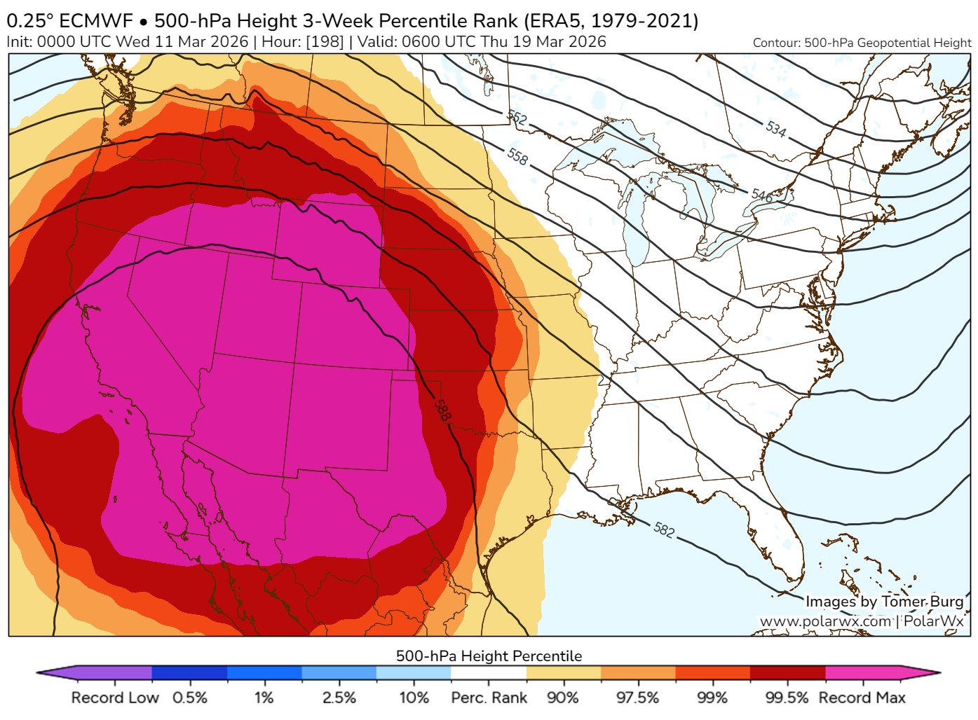
I do genuinely wish I had better news to share, but…well, the next 10-14 days look truly exceptional across the Western U.S., and not in a good way. A widespread, prolonged, and exceptionally intense March heatwave will begin by Thursday, peaking first on Friday (across Southern California) and then again in even more intense and widespread fashion (stretching from clear from San Francisco to Phoenix to Denver) by the middle of next week. In fact: the strongest mid-tropospheric ridge ever observed in the southwestern U.S. in March is expected to develop by Friday, and then will probably go on to break that new record (set this week) when it re-organizes into an even broader and stronger ridge next week.
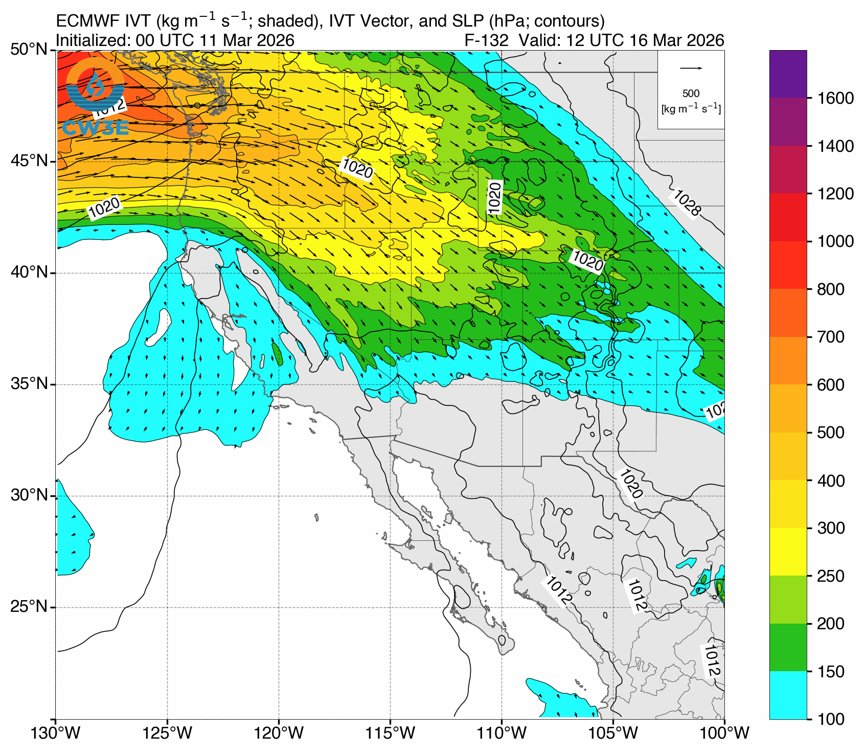
Get ready…for some meteorology! The atmospheric dynamics proximally linked with this historic ridge-building-then-amplification-in situ process are quite interesting to consider. Upstream of the huge Western U.S. ridge, a persistent flow of subtropical moisture will surge into Washington State and the Pacific Northwest (this atmospheric river will bring copious rainfall from about Portland, OR northward–along with potential flood risk into the weekend). Simultaneously, and relatedly, a very deep Kona Low will bring torrential rainfall and severe thunderstorms (with associated hazards) to the Hawaiian Islands in the coming days. As exceptionally warm and moist air ascends within the “moist conveyor belt” region of the low near Hawaii and enters the atmospheric river transport corridor into the Pacific Northwest, it will transport an airmass characterized by high “moist static energy” (MSE) into the northern flank of the big Western ridge. The abundant upstream condensation over the Central Pacific into the PacNW will contribute to a classic diabatic “ridge-building” event across the West, wherein warm moist air aloft helps to (first) strengthen the magnitude of mid-tropospheric geopotential height anomalies and (subsequently) allow for a “heat dome”-like effect to develop as subsidence within the strengthening ridge causes adiabatic warming and drying of said air as it descends within the core of the ridge. This somewhat complex and counterintuitive process–whereby unusually intense low pressure and associated precipitation in one region can lead to unusual high pressure and anomalously warm/dry conditions in an adjacent one–is actually fairly reminiscent of what transpired during the record-shattering June 2021 heat event in the Pacific Northwest and British Columbia (and in other record-shattering heatwaves in Europe in recent decades). Fortunately for the Western U.S., this is taking place in March (rather than June) and maximum temperatures will not be nearly as extreme in absolute terms as during that event, which occurred close to the summer solstice when incoming solar energy was near its maximum. But it is certainly striking to see at least a somewhat similar setup this time around, and it does make me a bit circumspect regarding what this kind of heat event would look like in the Southwest were it instead occurring in May or June.
Still, this is very likely to become a historic heat event for the time of year. The heat will certainly be record-breaking, and perhaps in some locations record-shattering (i.e., it will break existing records by wide and statistically remarkable margins). Nearly every observing site in most Western U.S. states will break daily records; some for 7-10 days consecutively. Many locations will also break all-time monthly March temperature records (quite a feat during the first half of the month), as well as all-time records for “earliest 80/90/100/even 110F temperature.” Believe it or not, some desert locations may even see temperatures that approach or exceed *April* records–and again, I emphasize, we are still in the first half of March! Other meteorological commentators have already opined that they haven’t ever seen a March heat event like the one currently expected to unfold this month, and I generally agree with that assessment. The combination of projected intensity, duration, and spatial extent of this event are all individually remarkable–and, together, make the predicted event overall truly extraordinary.
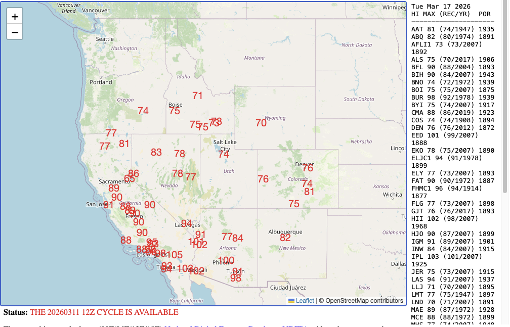
Some especially remarkable numbers: Parts of the Los Angeles basin could approach 100F Thu and Fri this week, with even higher temperatures possible again by the middle of next week. The lower deserts of southeastern California and southern Arizona will certainly exceed 100F, and possibly 110F–which would be (by far) the earliest in the calendar year such extreme temperatures have ever been observed in this region. Parts of the SF Bay Area and the entire Sacramento Valley could see temperatures approach or even exceed 90F locally; the Colorado Front Range (including Denver–the “Mile High City”–will likely get well into the 80s). I will repeat, once more for emphasis, that we are still in the first half of March.
No March Miracle: Mountain snowpack, already very low, may reach unprecedented levels following historic heat, with major water/wildfire implications for spring/summer to come.
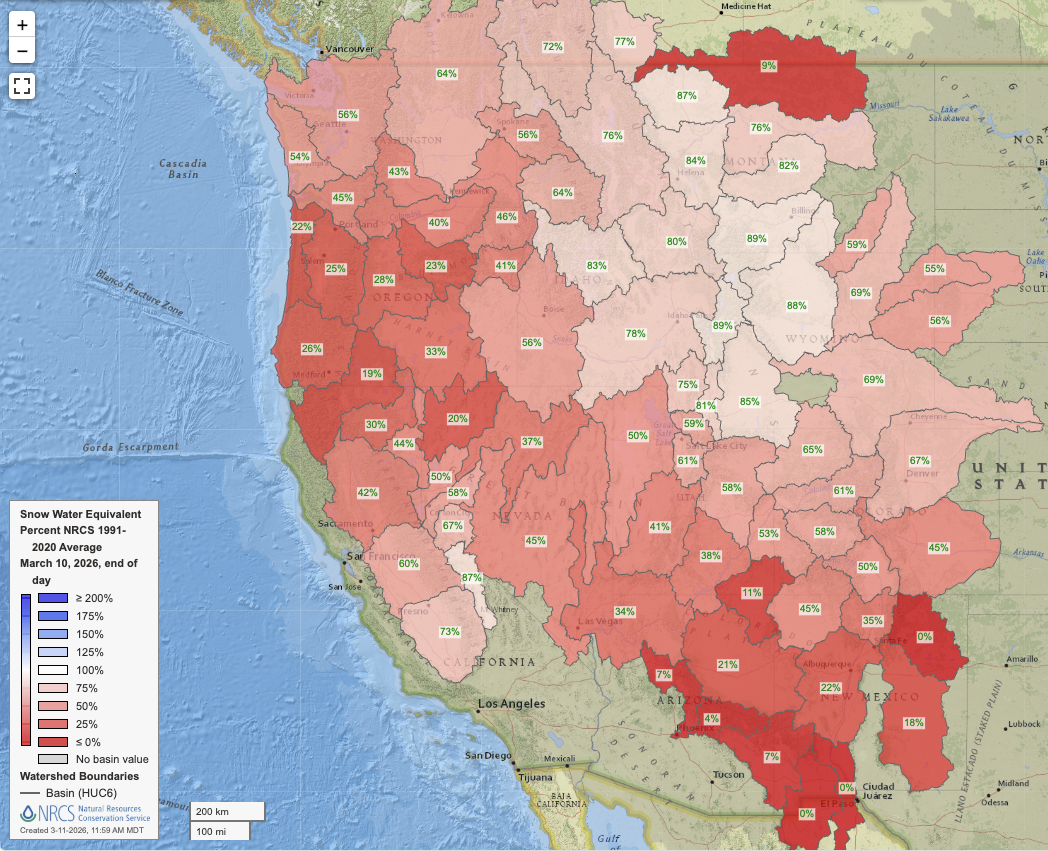
The Southwest will experience what is effectively the opposite of a “March Miracle”–that is, a period of near-zero precipitation and exceptionally warm temperatures leading to rapid melting of mountain snowpack in a year when said snowpack was already in very poor shape. After modest February and early March stabilization in some pockets of the West (including the central/southern Sierra and parts of the upper Colorado watershed), snowpack water content (SWE) has already started decreasing again in the past week during what would usually be a period of substantial accumulation. During the upcoming period of exceptional and prolonged heat–which will bring t-shirt and shorts weather even into the higher mountains of the American West–snowmelt will accelerate dramatically. Snowpack is already near record low levels in many hydrologic basins, and I would expect that to become more of the rule than the exception over the next 10-14 days as spring or even summer-like temperatures and low/no precipitation become the rule nearly region-wide. April 1 snowpack may well be the worst on record across many, if not most, Western U.S. watersheds. And despite a decent precipitation year in California’s Sierra Nevada, the dramatic recent reversal in fortunes here combined with at least a 10+ day period of dry conditions and exceptional warmth will likely yield shockingly low April 1 SWE numbers, especially relative to the observed seasonal precipitation accumulation.
There may even be a noticeable uptick in wildfire activity in some parts of the West during what is (in most years) one of the two most inactive calendar months historically. The highest risk will likely be during episodes of warm/dry downslope winds in the severe drought region along the Rocky Mountain Front Range, where critical to even extremely critical (“particularly dangerous situation” risk) could arise locally depending on wind conditions. Elsewhere from the Four Corners, Southern Rockies, and into southern California, the possibility of wildfire events will steadily increase in the coming days as record heat and dry conditions overlap. I do want to emphasize that extreme fire risk is not expected in these regions; it is March, following an unusually wet season to date in Southern California, so vegetation is nowhere near peak seasonal dryness. Also, no extreme offshore winds are expected in CA during this period (though breezy north/northeast winds are possible at times). So there will likely be periods of elevated fire weather from California eastward to Colorado, with somewhat higher risk possible in some parts of CO/NM into Central Plains during wind events amid drought conditions there.
The more significant wildfire-related implications, though, will likely come later this spring into summer. I expect an early and intense start to fire season in the Four Corners region especially, later expanding into most of the Western U.S. higher elevation forested regions. This was already the case due to very low snowpack and a record warm winter as of early March, but given the outlook for a 10-14 day period of exceptional heat and dryness to come and the prospect of record-low snowpack synchronized across multiple regions, that further elevates my level of concern regarding the potential for greatly elevated fire risk later this summer especially in forested settings at higher elevations and especially before the summer monsoon arrives. I do think we could see a much more active higher elevation forest fire season across the U.S. West this summer compared to the last few years, during which fire conditions in these settings have been much milder.
The upcoming extreme heat/extraordinary March snowmelt event will likely also accelerate already major concerns about water supply in regions primarily supplied by the Colorado River. A historically unprecedented divergence between observed precipitation and spring/summer runoff is possible, and this raises the potential for even “worse than predicted” basin-scale runoff.
Odds of “significant” El Niño event in 2026 continue to rise; substantial CA & SW US impacts possible by summer
As if the short-term outlook were not enough…well, there are some potentially pretty dramatic changes unfolding right now in the tropical pacific that may have major implications for California and Southwestern U.S. climate from later this spring into summer and beyond. Current atmospheric conditions (including frequent, strong, and ongoing westerly wind bursts in the Pacific tropics) and oceanic conditions (including a very large volume of subsurface warm water “sloshing” eastward across the Pacific, plus strong warm anomalies developing near the coast of Peru), combined with recent multi-model model ensemble predictions from most or all major global centers (which depict a rapid warming of the eastern tropical Pacific between now and mid-summer) strongly point toward the development of El Niño conditions by this summer. But perhaps more significantly, they specifically point to the elevated potential for an especially intense, east basin-centered event (i.e., the type with the greatest potential to generate classic hydroclimate teleconnections in the SW U.S.). The flagship ECMWF ensemble is, in fact, notably high odds of a very strong “super El Niño” event by August.
There are some major caveats: it is still early in the year, and we remain (technically) on the wrong side of the so-called “Spring Predictability Barrier.” But on the other hand, there is clear real-world alignment with conditions that would be expected to occur prior to a high-end El Niño event (so not just model predictions of such); also, there is remarkably strong inter-model ensemble agreement at this time for at least moderate EN conditions by mid/late summer. So while there is still real uncertainty, there may be more confidence than usual from a March perspective that the odds of a major ENSO shift will occur later this year.
Impacts in California could begin as soon as later this spring, as exceptionally warm near-shore ocean temperatures will likely persist at least into spring-summer and likely beyond. For this reason, I strongly suspect that the coastal marine layer will be much weaker this year than during recent chillier summers near the immediate CA coast; it might even continue to feel pretty muggy on warmer days (especially in SoCal, but also along the Central Coast and even NorCal by later in the summer). These warm Pacific coastal sea surface temperatures, combined with favorable upper atmospheric conditions, could also enhance Eastern Pacific summer/fall hurricane activity in 2026–increasing the odds of “tropical remnant” events affecting California and the SW by Jul-Oct (which, historically, have resulted in both heavy rainfall/flash flood events but also dry lightning…depending on the exact set-up). For now, that’s all I’ve got to say on El Niño, but I’ll dive much deeper in the months to come.