Unusually active October continues across California, but winter doesn’t look so promising
Wild October weather across much of California
October in California is unlike autumn virtually anywhere else in North America. It’s a calendar month during which searing heat and extremely dry Santa Ana winds can occur just as easily as powerful windstorms and driving rains. Indeed, we’ve already seen both record heat and record rainfall in October 2016! Already this month, we’ve witnessed a prolonged heatwave in Southern California give way to strong winter-like storms in Northern California–fueled in part by the extratropical remnants of a former West Pacific typhoon. More recently, over the past weekend, atmospheric moisture and instability swept up ahead of an incoming Pacific trough produced a prolific and remarkably prolonged (not to mention largely unexpected) thunderstorm outbreak across much of Southern California. To date, precipitation across NorCal is generally well above average, but well below average in the south–perpetuating the north-south divide that has persisted over the past 12 months.
Extraordinary amount of #SoCal lightning past 36hr–thousands of strikes reported! Nearly all south/east of downtown #LosAngeles. #CAwx pic.twitter.com/jS8RywcXJw
— Dr. Daniel Swain (@Weather_West) October 25, 2016
Late-week storm to entrain copious tropical moisture from “Seymour”
And there appears to be a fair bit more to come over the next 10 days or so as an unusually active weather pattern continues across the far eastern North Pacific. Significant rainfall occurred once again across much of NorCal over the past 24 hours–just a prelude to a series of stronger systems slated to approach the coast beginning later on Thursday.
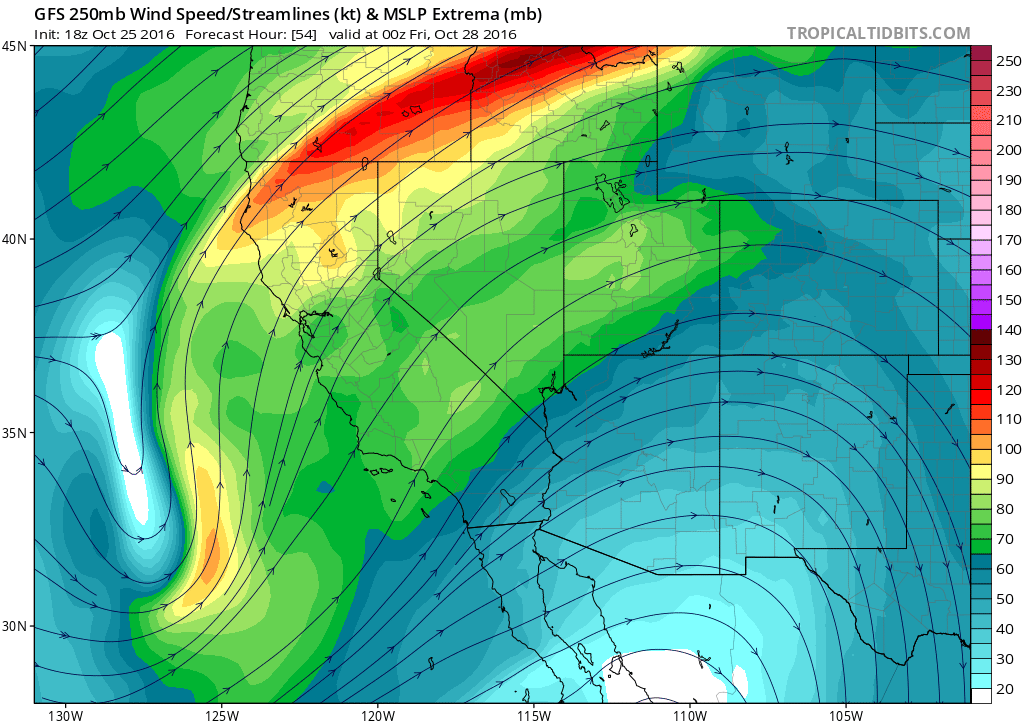
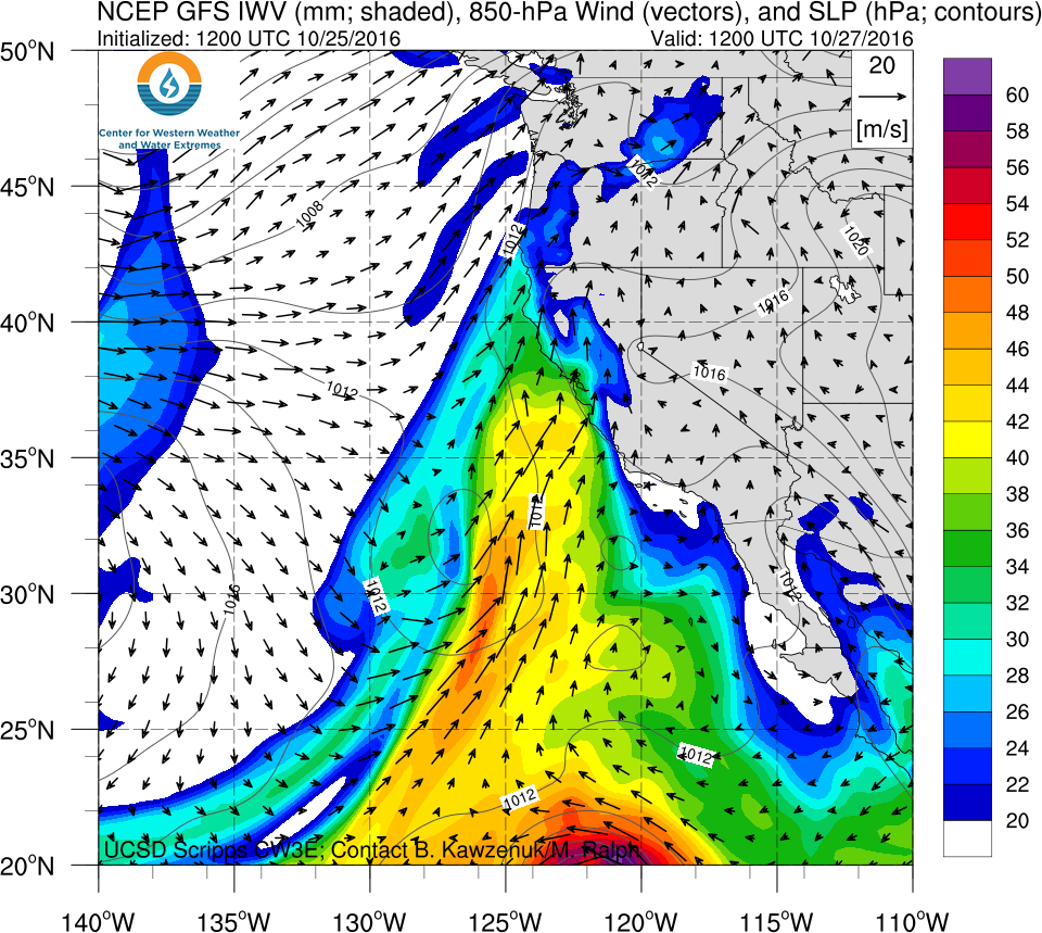
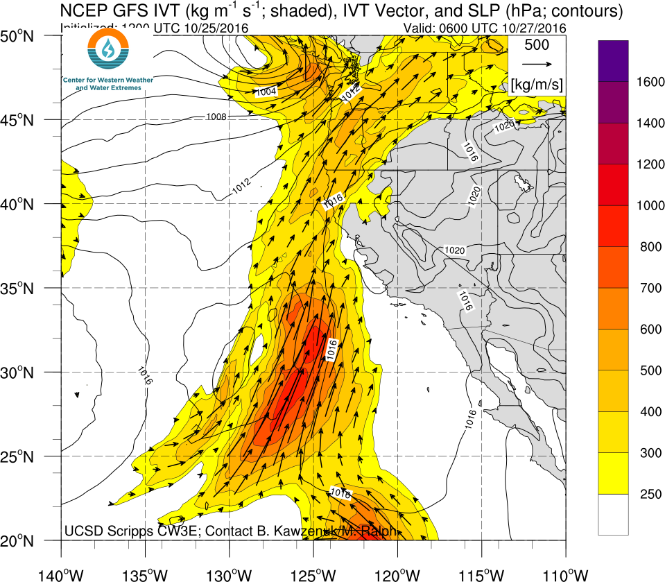
The most interesting of these is probably the first storm, which can currently be seen developing on satellite imagery south and west of California. This system is deepening at an unusually low latitude–far south of the typical October storm track along the West Coast–which will likely allow it a rare opportunity to directly tap the rich atmospheric tropical moisture reservoir associated with now-Hurricane Seymour. This trajectory will allow for the formation of an atmospheric river with almost due south-north orientation–rather different from the more familiar “Pineapple Express”-type event, which typically have origins closer to Hawaii.
Earlier model forecasts (particularly the ECMWF) had been indicating the potential for a very strong surface low to develop near the California coast on Thursday, which would have brought the potential for strong winds to much of Central California.
More recent model runs have backed away from the strong wind scenario, and it now appears unlikely that damaging winds will occur (though gusty winds are certainly still possible in some spots).
The Thursday system still has the potential to be rather impressive from a precipitation perspective, however. There remains a fair bit of run-to-run and inter-model disagreement regarding exactly how much precipitation will fall and where the precipitation bullseye will ultimately land, but it does look pretty likely that a broad swath of California from the Central Coast up through Mendocino will get quite wet over the next five days. In fact, given the very large amount of tropical moisture that may become entrained into the warm sector of the developing surface low, it’s possible that the models are presently underestimating the precipitation potential in this unusual setup (particularly in the coastal mountains). At the moment, it appears that the heaviest rain will stay north of southernmost California (although, fortunately, the bone-dry Central Coast should not miss out on this one). On the other hand, this is a system with real potential to “overperform” model precipitation forecasts in Southern California given its abundant moisture tap (with vertically integrated water vapor approaching record levels for October).
This system will also be a warm one by California standards–temperatures during rain even in NorCal could be as high as the upper 60s, and perhaps into the 70s in SoCal. Given the system’s warm, moist, and somewhat unstable tropical origins–combined with some respectable upper-level support from the offshore low–there could be a fair bit of thunderstorm activity from late Thursday into Friday from about the Bay Area southward, perhaps even in the Los Angeles and San Diego areas.
The Pacific storm track will remain active following the Thursday storm but will shift northward slightly–keeping NorCal quite wet but preventing SoCal from seeing additional much-needed precipitation.
Latest data regarding coming winter not encouraging for California
I’ve mentioned before that seasonal precipitation forecasts are still very difficult for a variety of reasons–and it’s easy to oversell just how much confidence we have in a specific outcome in a given year. However, there are several factors that currently don’t paint a very promising picture from a drought mitigation perspective–October’s wet conditions notwithstanding.
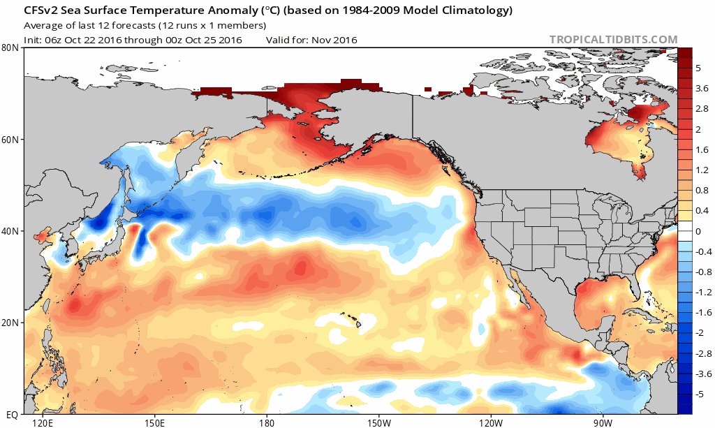
The monthly-updated North American Multi-Model Ensemble, as I discussed previously, has been hinting at a warm winter in general across California with the potential for a “wet north/dry south” split in precipitation. The American CFS model–which generates new publicly available seasonal forecasts each day based upon continuously updated ocean temperature and sea ice conditions–is starting to suggest that California dryness this coming winter could be even more widespread. In fact, in recent weeks the predicted atmospheric pressure pattern for mid-winter has started to look…eerily familiar.
How concerned should we be about a 2016-2017 return of the Ridiculously Resilient Ridge? Well, the tropical Pacific Ocean has been edging back toward a La Niña-like state, with relatively cool water in the eastern Pacific. Meanwhile, very warm conditions are expected to return to the tropical West Pacific over the next few months–a setup that is linked to unusually strong high pressure over the northeastern Pacific.
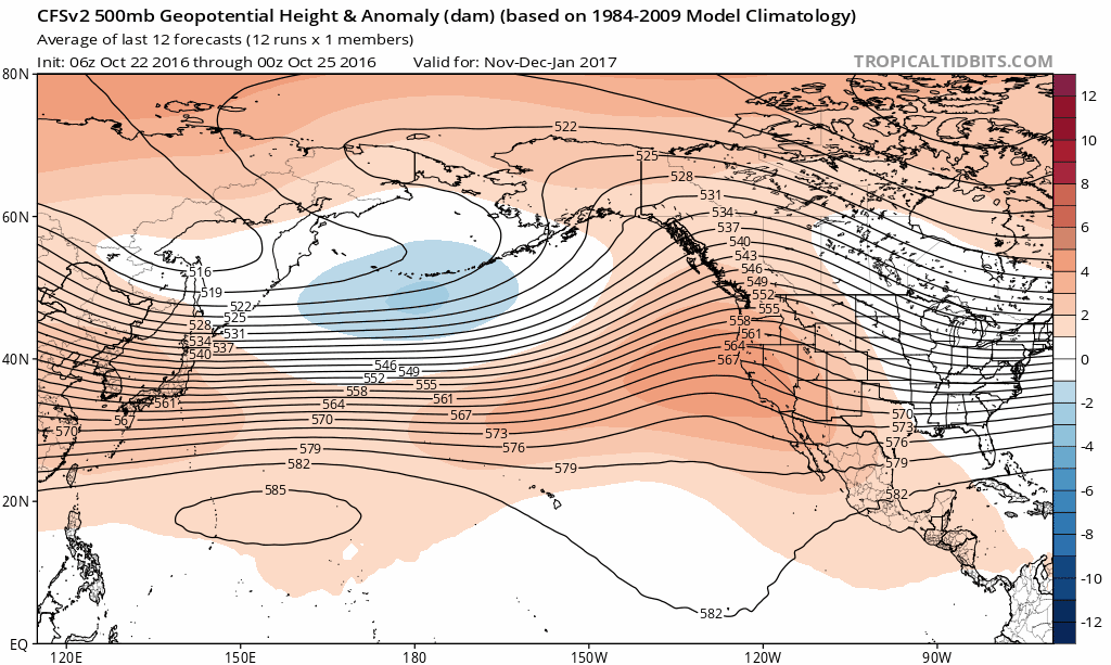
Also noteworthy is the generally anomalous state of the Northern Hemisphere atmosphere this autumn, which we can no longer blame on last season’s powerful El Niño. Extraordinary warmth continues across many areas–especially in the Arctic, where seasonal re-freeze of the Arctic Ocean has been occurring at a record-slow rate (leading to record-low ice extent in October). The unfavorable state of the tropical Pacific Ocean, plus the high likelihood of persistent warmth yet again this winter, suggests that we’re still likely to be talking about the “ongoing California drought” well into 2017.