Increasingly unusual dry autumn conditions persist; fire season continues until further notice
Following slow start, California fire season roars into high gear
Unfortunately, the weather situation in California has changed very little since my last post. The warming and “periodic offshore wind events” discussed in the last post did indeed come to pass, and unfortunately with fairly dramatic impacts in many regions. A prolonged period of offshore winds affected both northern and southern California over the past 2-3 weeks, and some regions (especially the far North Bay region) experienced some of the most extreme such offshore winds observed in years (including hurricane-force sustained winds and at least one 100mph gust in the hills above Santa Rosa). These locally powerful winds coincided with a much more widespread incursion of a dessicatingly dry airmass nearly everywhere, even on the immediate coast. In fact, the amount of atmospheric water vapor over both northern and southern California has reached record low levels (for the time of year) at various points over the past 10 days.
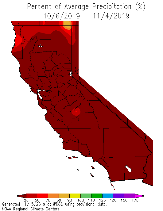
Needless to say: virtually no rain at all has fallen over California over the past month. As I noted in the last post: dry Octobers are not tremendously unusual in California, nor are predictive of a dry winter to come. But October 2019 ended up being a shut-out in the precipitation department in many regions–yielding the 10th driest October on record in over 100 years of record-keeping. More significantly, though: this extremely dry and relatively warm pattern has now persisted into November, and appears likely to continue for at least another 10 days. Such dry conditions are now quickly becoming more unusual as we get further into November, especially in the northern part of the state. And, as we explored in previous peer-reviewed research and as I summarized in a previous blog post: increasingly dry autumns, and later “rainy season” onset, are likely to become a signature of a warming climate in California.
As a result of these extremely dry and occasionally very windy conditions, the risk of wildfire has increased dramatically in recent weeks. Unfortunately, this extremely high risk potential was realized in portions of both northern and southern California. The largest wildfire of this outbreak, the Kincade Fire in Sonoma County, burned nearly 80,000 acres and hundreds of homes–resulting in the largest evacuation in Sonoma County history. Despite extensive damage from this fire outbreak, however, this event was mercifully less destructive and deadly than several other fires in recent memory.
Due to the new PG&E policy of widespread and relatively low-threshold “public safety power shut-offs,” however, over 3 million Californians were directly affected by this sequences of offshore wind events. Portions of Northern California experienced long-duration power cuts during and after the wind events–including regions that themselves did not experience strong winds (and were merely supplied by power infrastructure running through high-risk zones). If you’re interested in my personal opinions on the PG&E PSPS policy, I’d again refer you to my last blog post. But I will add this: if we see another round of significant offshore winds before the rains arrive in earnest this year–as is a statistical likelihood–there may yet be another round of widespread PSPS power cuts before the winter.
A good way to quantify the effect this anomalous dryness, warmth, and wind has had on California fire risk is to consider recent observed trends in aggregate fire risk metrics–in the below case, the “Energy Release Component” (ERC) of vegetation in different regions. An aggregate measure of vegetation flammability, current ERCs are running at or above record levels for the calendar date virtually everywhere in the state–from the coastal brush regime in coastal SoCal to the coniferous forests in the Sierra Nevada. What does this mean in practical terms? Well, similar to recent autumns (which featured some particularly awful fire events), wildfire risk is essentially near/at historically unprecedented territory for this late in the season. This does not necessarily mean we will see additional large/destructive fires this year, but it does mean that the potential is certainly there–and could be realized if we experience additional severe wind events. In short: fire season will continue until further notice.
No rain on near-term horizon; only hints in long-term
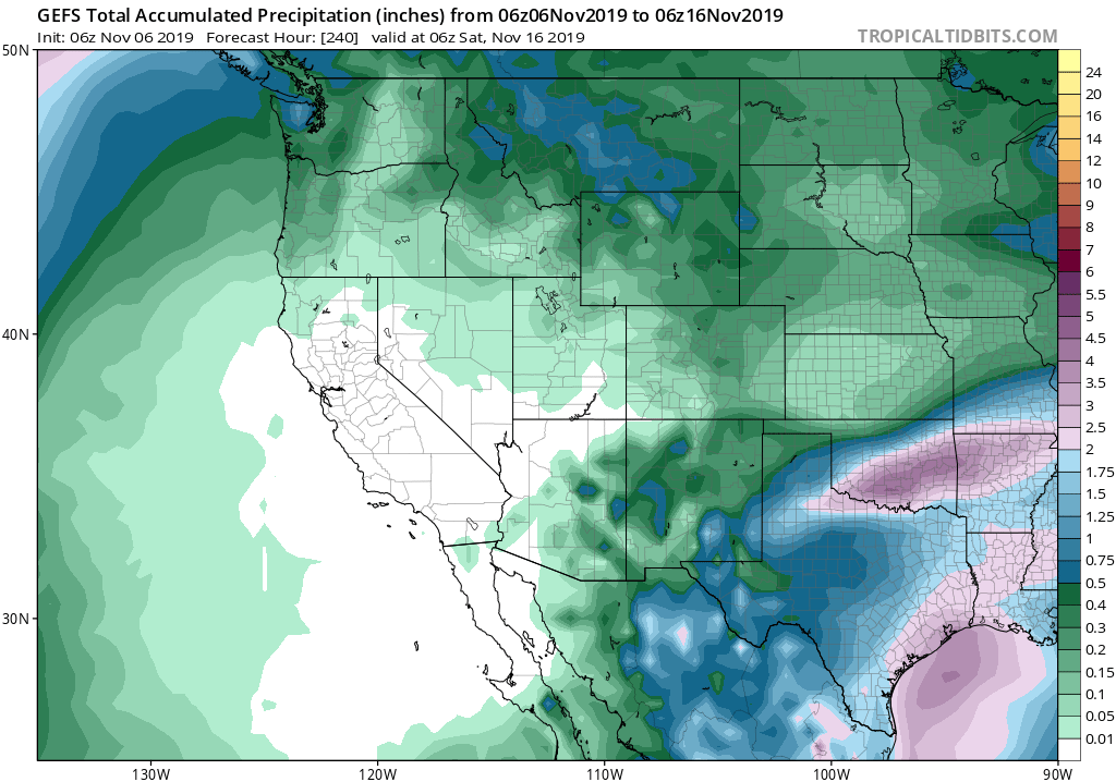
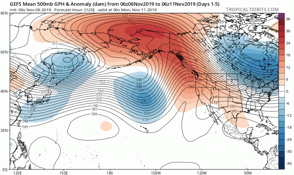
The forecast for the next 10+ days can be summarized quite succinctly: dry, with increasingly warm temperatures (especially along the coast). The culprit? A strong and persistent ridge along right along the entire West Coast of North America. Unlike the pattern earlier this month–which brought lots of offshore wind events but relatively cool temperatures–the upcoming portion of our prolonged autumn dry spell will feature well above average temperature virtually statewide. That’s because the primary ridge axis will be directly overhead (rather than to the west of California). This will set up a pronounced “Warm West/Cool East” temperature dipole pattern (sound familiar?)–keeping California (and, indeed, much of the west) high and dry while the eastern half of the continent suffers through very cold (and snowy) conditions.
The strong West Coast ridging responsible for the upcoming 10+ days of dry/warm weather in California is part of a strikingly well-defined anomalous atmospheric “wave train” across the entire Northern Hemisphere. It appears that this pre-existing wave pattern will likely be further amplified by the downstream effects of Supertyphoon Halong in the West Pacific. This tropical cyclone–which is among the most intense such storms ever recorded in the satellite era–will inject moisture and energy into the jet stream. While this kind of tropical recurvature can sometimes result in significant early-season precipitation in California, it can also have precisely the opposite effect. In both cases, it energizes the West Pacific jet stream; in this case, though, the enhanced storm activity over the Central Pacific will actually act to “pump up” the preexisting ridge along the West Coast (another half wavelength downstream).
Also notable is the almost unbelievable persistence of warm across portions of Alaska in recent days (and months…years…decades…you get the idea)–a pattern that is also expected to continue for the foreseeable future. Sea ice is essentially absent in the Chukchi Sea for the first time on record this late in the season. Aside from the profound local and regional effects this is having in Alaska, this huge area of missing sea ice is acting as a pretty substantial lower atmospheric heat source–a process that will continue until the ocean finally freezes over later this winter (one hopes). It’s not entirely clear what impacts this kind of anomalous surface heating has on downstream atmospheric wave patterns–as I’ve previously noted, this is an area of very active research and hot debate in atmospheric science. But it does seem plausible that this configuration may be contributing to the amplification of the large-scale wave pattern over North America–including the displacement of a large Arctic airmass into the Central and Eastern U.S.
Right now, there are only weak hints at some potential for precipitation in northern California during the last 10 days of November. Model ensembles still indicate a rather high likelihood of ridging and below average precipitation for the next 2-3 weeks–and, indeed, even longer than that. That doesn’t necessarily mean that a precipitation event or two won’t sneak in under the ridge at some point–but right now, there are no particularly encouraging signs of a large-scale pattern change on the horizon. If anything, there are subtle hints that the North Pacific ridge axis will retrogress (move westward) slightly during the latter half of November–perhaps opening the door to another round of inside-slider systems and possible offshore wind events. That’s a bit speculative at this point, but the key message continues to be: continued dry and increasingly warm over the next 10 days–and perhaps longer than that.
No strong predictors, but odds of dry winter rising
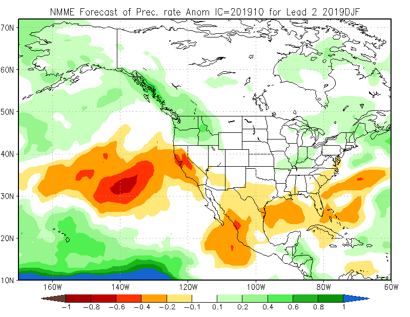
As I’ve discussed recently, seasonal precipitation outlooks are not particularly skillful in California (in the absence of strong ENSO events, at least, which we do not have this year). That said, there is an unusually high level of agreement emerging across a range of predictive tools suggesting that below-average precipitation is more likely than usual to persist for much of the winter. The North American Multi-Model ensemble is suggesting a rather dry winter across much of California–which is consistent with the ECMWF seasonal outlook. While I wouldn’t take these forecasts too literally, I do think there is unfortunately enough evidence at this point to say that there are increased odds of a drier-than-average winter this year. Again: I would emphasize that’s not an especially high confidence forecast call. But given the current dryness and ongoing extreme wildfire risk, I know all eyes are on the Pacific storm track–and at the moment, signs are not particularly encouraging.
One bright spot from a water supply perspective: California’s surface water supplies (i.e., reservoir levels) remain in very good shape for the time of year, bolstered by last year’s wet winter and excellent snow season. So at least in that respect, we do have a bit of a buffer to weather a single dry year. Stay tuned!