Big storms on the way for Norcal!
Overview
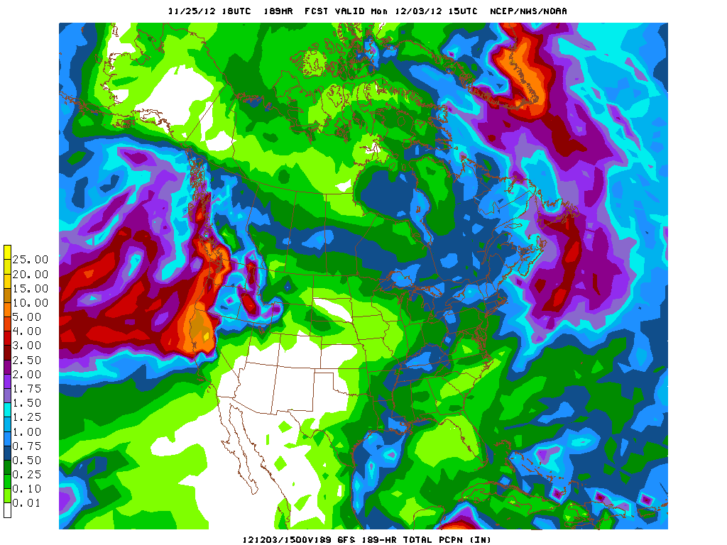
After 1-2 year lull in powerful winter storm activity across California, a series of very strong storm systems will come ashore this week and bring widespread heavy rainfall and strong winds to the northern half of the state. There remains a considerable amount of uncertainty regarding the exact location and magnitude of rain and wind impacts, but right now it does appear that winds could be locally damaging at times over the next week or so and rainfall totals by this time next week could be extremely impressive.
Short Term Discussion
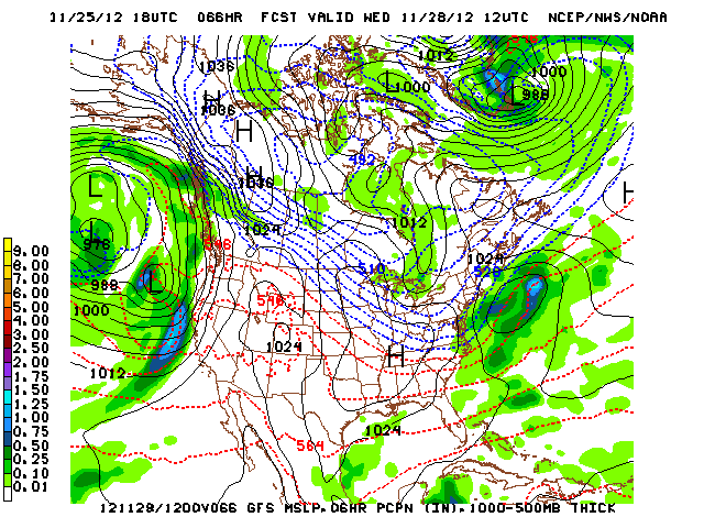
A deep longwave trough is expected to develop over the Eastern Pacific early this week, with its axis remaining around 1000-1500 miles off the coast of California. By Wednesday, a strong disturbance is expected to round the base of the deep trough and develop a surface low as it approaches the far Norcal coast. This initial system will be quite strong, bringing a period of widespread heavy rain to Norcal and probably a period of strong to very strong winds as well. The GFS is currently indicating a sub-990 mb low near the OR/CA border in relatively close proximity to a modestly strong surface high pressure area over the Desert Southwest, and a pressure gradient of this magnitude could easily produce the strongest southerly winds we’ve seen in at least a couple of years here in NorCal. A note regarding the 11/25 18Z operational GFS: I’m seeing 850 mb wind speeds of 65 kts, which is very impressive. While sustained winds of this magnitude will not be observed at the surface, gusts near or over 65 mph are certainly possible.

This system will exit the region quickly by Thursday, and it’s possible there may even be a brief dry period on that day. Soon thereafter, though, warm advection rains from the next storm will begin in earnest over the North Coast and spread quickly southward. By Friday, a long zonal fetch of very high PWs will be riding a strong low-level jet into NorCal, producing a 200-400 mile wide band of heavy to very heavy rain. This is the classic setup for a very moist “atmospheric river” event, which can produce tremendous amounts of rainfall if it remains stationary for any length of time. It’s not entirely clear where this axis of potentially excessive rainfall will set up, and there could be pretty sharp rainfall gradients north and south of the main band. I will say this, though: wherever it does set up, favored areas are almost certainly looking at double-digit rainfall totals.
Long Term Discussion
And…the parade of storms does not end there. The GFS and ECMWF are both depicting at least one more big storm capable of producing heavy rainfall and potentially strong winds next weekend, with the potential for an additional 1-2 major storms next week. Rainfall totals by the middle of next week are likely to be very impressive in Norcal, and if currently progged conditions actually come to pass there will be flooding problems at least in creeks and streams and probably in the faster-responding river basins, as well. As for Socal, there will almost certainly be rain at times over the next week or so, but it does appear that the heaviest stuff will by far be focused on the northern and central parts of the state. Towards the end of the storm series, I think there’s a good chance that one of the stronger storms will finally dig southward enough to give Los Angeles and San Diego some substantial rain and wind. That’s quite a ways out, though. In any case, it does appear that we’ll be erasing some rainfall deficits in short order…

© 2012 WEATHER WEST
Big storms on the way for Norcal! Read More »