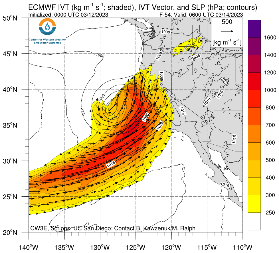
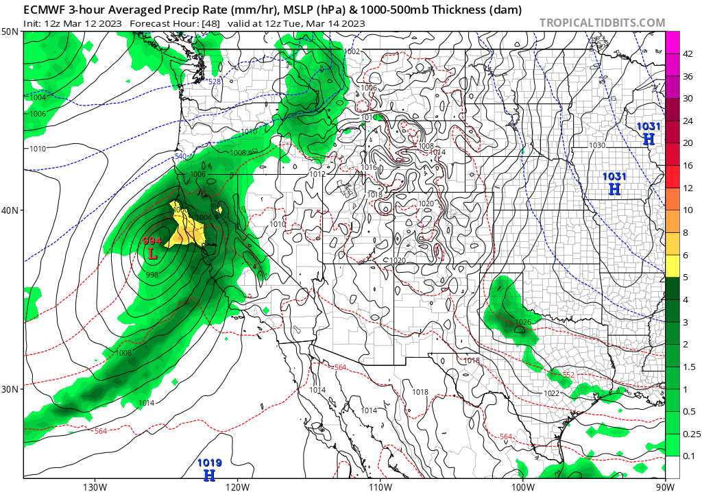
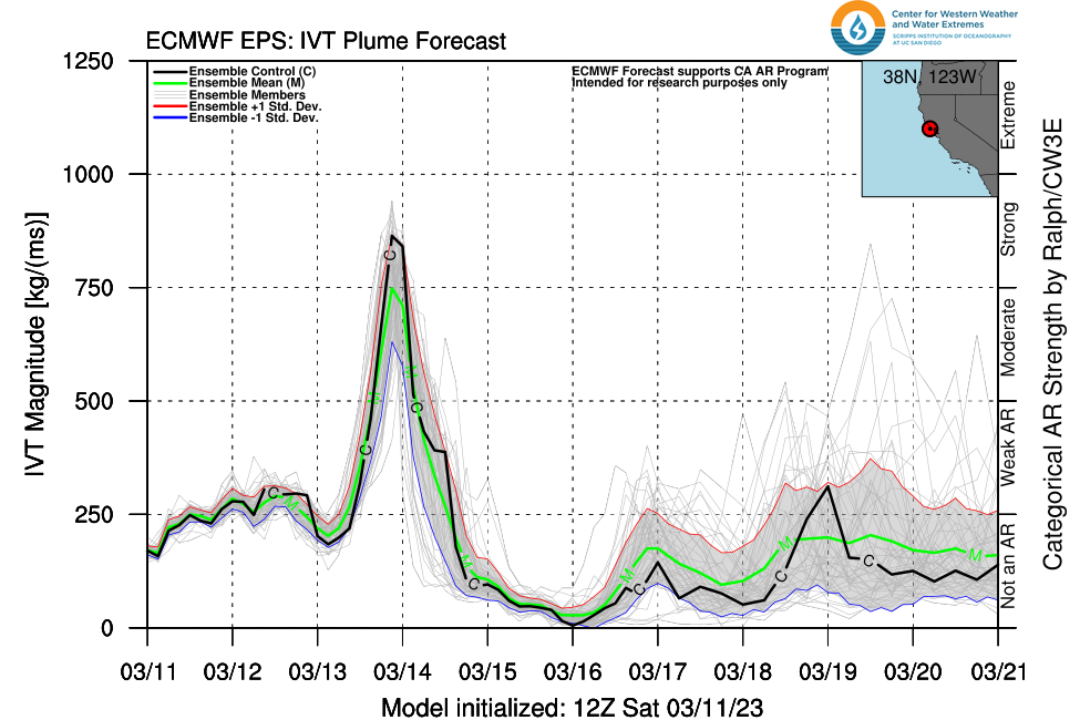
Another strong storm may bring even more substantial and widespread flooding & wind-related impacts late Mon-Tue
Wild times in the California weather world
Welp, here we go again. After a long period (a full season, really) of different kinds of exceptional weather conditions all around California, there’s yet one more big storm to come in the immediate future (discussed below). But what has transpired in the past, oh, 48 hours or so? Well:
- A “Pineapple Express”-type atmospheric river brought very heavy precipitation (heavy low-mid elevation rain, including atop an existing snowpack in many places, and extremely heavy high elevation snow) to central California. Widespread and locally serious flooding occurred in the Southern Sierra watersheds (including Kern and Tulare watersheds) as well as in the agricultural centers of Monterey/Santa Cruz Counties (especially the community of Pajaro, near Watsonville, that has been completely inundated by rising waters caused by a nearby levee break on the Pajaro River).
- Despite lower and middle elevation snowmelt, the addition of new high elevation snow and absorption of rainwater by the snowpack at middle elevations has resulted in what appears to be a new record regional snowpack (in terms of SWE) for the Southern Sierra, and possibly also for the Central Sierra. These snowpacks will likely grow yet more this coming week–exceeding all-time record levels by an even wider margin. Although this record SWE will most likely not contribute substantially to flood risk this week, I am becoming increasingly concerned what it may imply regarding flood risk from late March through April or May. (Stay tuned.)
- The “break” between storms in NorCal has been anything but in some localized spots. Yesterday, several areas of thunderstorms developed in the Central Valley, including isolated true “supercell” thunderstorms that ultimately produced damaging large hail, flash flooding, and at least one confirmed tornado in the Central Valley and lower Sierra foothills. Additional isolated severe storms are possible this afternoon, posing hazards in their own right but also keeping soils saturated ahead of the next big storm.
Another moderate to strong atmospheric river Mon-Tue may produce “outsized” flood and wind impacts due to extremely wet antecedent conditions
There is an unusual amount of uncertainty for such a short-range forecast regarding exactly how the Mon-Tue atmospheric river will look at the point of landfall, and this has some pretty consequential implications for flood and wind damage-related impacts. Here’s a quick overview:
A moderate to strong atmospheric river, once again with deep subtropical origins (i.e., the “Pineapple Express”) will make landfall in northern and/or central California–bringing a period of widespread moderate to heavy rainfall to a wider swath of the state than the Friday event (i.e., some moderate to locally heavy rainfall will extend into most of SoCal as well). Unlike the previous event, this AR will be associated with a rapidly deepening surface low rather close to the NorCal coast. This will raise the potential for widespread and possibly damaging winds well beyond what was observed in the previous storm. It will also potentially amplify the AR on final approach, depending on precisely how much the surface low deepens.

The GFS and ECMWF ensembles do not currently agree regarding how strong the AR will be, and the difference stems from a disagreement over the strength and exact position of the above-mentioned surface low. The ECMWF is stronger and closer to the NorCal coast with the surface low, and hence its depiction is of a much strong AR affecting primarily NorCal (and, to a lesser extent, Central CA). The GFS is weaker with the surface low and therefore more diffuse with the IVT plume–making for a broader but weaker AR and a precipitation bullseye along the Central Coast and into parts of SoCal. (Why are there such big difference between models? The CW3E had an interesting discussion on Twitter this morning.)
If the ECMWF is right, expect a more powerful AR overall with a more northward focus. If the GFS is right, expect a somewhat weaker AR overall but with a broader swath of heavy precipitation across already flood-affected areas of Central CA.
Either way, this storm appears to have better dynamics (thanks to overhead jet streak and proximity of deepening nearby surface low). While I do not expect precipitation totals from this storm to be exceptional, peak hourly rainfall *rates* may well be higher with this storm (including the possibility of embedded thunderstorms in a subtropical airmass). Additionally, soils are now supersaturated everywhere across the northern 2/3 of CA (at least) and rivers are running high/actively flooding. So the higher rain rates, plus exceptionally wet antecedent conditions, pose a threat of more widespread and serious urban, stream, and flash flooding on small rivers than the Friday storm in most places. Additionally, I expect a larger number of northern and central CA rivers to flood on Tue or Wed as a result of the heavy precipitation (along with a small amount of additional snowmelt) from this storm. I *still* don’t expect widespread major river flooding with this event, though we are getting to the point that there may be some isolated major river flooding along the Central Coast and in the San Joaquin Valley (especially places that are already having problems).

I would also expect to see pretty widespread wind-related issues in NorCal with this event, especially if the ECMWF’s deeper surface low is correct. Pattern recognition suggests this kind of setup tends to “overperform” in the wind and rain rate department even if 24 hour totals are not that extreme, so this storm could well have notable impacts in some areas (the very wet soil damage also compounds potential tree damage/power outage potential when combined with strong winds at the end of a storm cycle).

Hints of relief in the long range: still active, but less wet and stormy
I don’t have much time to discuss the long range except to say that it will probably still be active to some extent, but there are decent ensemble signals suggesting attenuation of the high amplitude flow pattern and a slowing/weakening of the California snow parade. Following the Mon-Tue storm, I don’t see any obvious candidates to produce major flood/wind impacts for the foreseeable future despite ongoing episodes of light to moderate precipitation at times–so storm and flood recovery prospects improve quite a bit after Wednesday. Stay safe out there!