A dramatic (but dry, in some places) cold frontal passage Tue–very windy and much colder
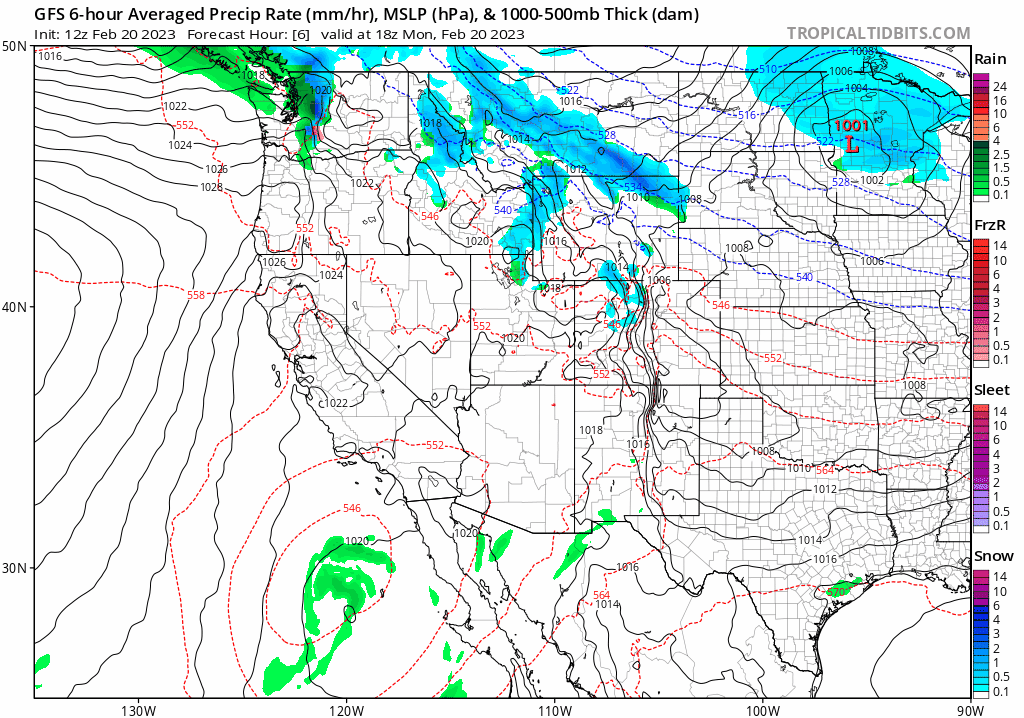
In unusually dramatic fashion, there will be a sudden shift from mild, dry, and quiescent weather conditions essentially statewide for the past 7-10 days to a much colder and more active weather pattern on Tuesday. A very strong cold front (by California standards) will sweep from northwest to southeast across the entire state later on Tuesday, bringing widespread strong and gusty winds and rapidly colder temperatures. Despite its dynamic strength (in terms of the sharpness of temperature and pressure gradients), this initial cold frontal passage will be quite moisture-starved and will only produce patchy light precip (mainly in the form of mountain snow, although a few rain showers are possible at lower elevations). Some spots, however, may remain entirely dry with howling/locally damaging winds and lowering windchills. Winds Tue into Wed will be notably and locally damaging almost statewide with the passage of this (dry-ish) cold front.
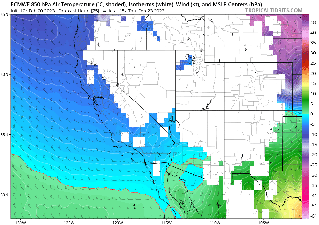
The front, however, will be just the beginning of a very active and interesting weather period to come for all of California. Behind the front, very cold air aloft will filter across all of California for the remainder of the week. An unstable airmass, characterized by occasional spokes of vorticity rotating through a very cold offshore trough, will bring periods of convective showers and perhaps isolated thunderstorms statewide. Snow levels will progressively lower with each passing wave of showers from late Tuesday through early Friday. Just how low they will go has been the subject of much social media speculation in recent days, and I’ll discuss that in some detail below.
Rare combination of a very cold airmass aloft plus enough moisture/lift for precipitation = substantial accumulating snowfall below 1,500ft elevation
This may ultimately end up as a weather week to remember for many folks in California. The main reason: accumulating snowfall is plausible down to very low elevations nearly statewide. On the one hand, I do continue to believe that some uninterpreted raw weather model predictions depicting widespread snow at sea level in Northern California are not correct…for a variety of reasons I’ve discussed extensively on Twitter and during past/upcoming office hours. On the other hand, this will be an exceptionally cold airmass given that there will be at least some precipitation around at times. So the potential is there for some very high impact snowfall down to elevations that rarely see such events.
Let’s consider the potential from north to south. (Please keep in mind these are my own personal estimates that are subject to change since the main event is still a few days out!)
Along the North Coast, including the coastal towns of Crescent City and Eureka, snow levels by late Wednesday may well fall all the way to sea level. Light snow accumulations are *possible* all the way to the beaches up in the far north. This has actually happened previously several times in the past decade, but the potential for more widespread or more substantial accumulations exists this time around. Just a few hundred feet above sea level along the North Coast–including the Hwy 101 corridor–locally heavy snow accumulations are possible.
In the northern Sacramento Valley, snow levels will probably fall into the lower foothills down to around 1,000 feet by late Thursday. Snow levels will locally fall as low as 500 feet in the northern part of the valley, which could mean that Redding and even some places slightly lower in the Valley could see some accumulations by Thu/Fri.
In Mendocino, Lake, and northern Sonoma/Napa counties, widespread snowfall is likely down to 1,000-1,500 feet with local snowfall possible down to slightly lower elevations Thursday night (perhaps down to 500 feet in a few locations). In fact, localized heavy accumulations are possible in some populated places that rarely see snowfall at all.
For the central and southern Central Valley (southern Sacramento and San Joaquin), accumulating snowfall is likely into the lower foothills (down to around 1,000/1,500 ft). Heavy snowfall is possible in some spots between 1,000 and 2,000 feet.
For the San Francisco/Monterey Bay Area: snow levels will likely fall into the 1,000-1,500 foot range by Thursday, though could locally fall slightly lower especially 1) in the North Bay and 2) if/where any heavier convective precipitation develops late Thursday night into Friday AM. Heavy snow accumulations (6-12 inches!) are quite plausible on the summits of Mt. Hamilton and possibly the crest of the Santa Cruz Mountains. Dustings to an inch or two may be pretty widespread throughout the coastal mountains/lower hills down to 1,000 ft, especially late Thu into early Fri, though the potential for localized heavier accumulations down to 1,000-1,500 feet does exist (mainly depends on how much precip is still around when the coldest air arrives late Thu). In the Santa Lucia Mountains, heavy snowfall is likely above 1,500 feet (likely exceeding a foot above 3,000 feet!).
In all of the above locations (except North Coast): I don’t expect to see accumulating snowfall below 500ft elevation. This is still a very low level, but is distinct from the kind of pattern that I’d expect to generate extremely rare/historic widespread accumulating snowfall at sea level outside of the North Coast. That said, there could be some local “flakes in air” essentially down to sea level just about anywhere in NorCal late Thu night and early Fri AM, and there’s perhaps a 5-10% chance that an intense precip band could drag brief wet snowfall below 500ft on a very localized basis (accumulation would be unlikely, but “novelty flakes” are not out of the question below 500ft in NorCal).
Farther south, snow levels won’t be *quite* as low in absolute terms but may be even more impressive in relative terms. I suspect snow levels may fall as low as 1,500 feet across most or all of SoCal by Fri/Sat, and locally down to 1,000 feet or so (especially across interior valley and desert regions). This means that virtually all of the southeastern deserts of California may see accumulating snowfall later this week, including most or all populated parts of the Antelope Valley. Substantial snowfall is possible throughout the Transverse Ranges, including higher valleys. Total precipitation accumulations are currently quite uncertain for late week in SoCal, but there is the *potential* for very heavy snowfall in the higher mountains of Los Angeles/SB counties (and perhaps flurries into the highest inland valleys).
In addition to actual snowfall, localized small hail and perhaps graupel will be possible nearly anywhere, including down to sea level and along the coast statewide. This is the kind of pattern, with locally heavy convective showers and very cold air aloft, that can produce *accumulating* small hail/graupel showers even down to sea level (with attendant travel concerns if you run into one of these hail showers on the road). So even if your location is too low in elevation to see real snowfall, you might well still see some “frozen white stuff” falling from the sky at some point this week!
Highlights: locally heavy accumulating snowfall in 1,000-2,000ft elevation band throughout CA (inc. lower foothills & deserts), true sea level snowfall along North Coast, and local flakes to 500ft or so elsewhere in NorCal
Aside from local travel disruptions (and perhaps excepting the far North Coast and Redding areas), any snow/frozen precipitation this week below 1,000 feet will be more of a novelty than anything else (though still quite notable). In the 1,000 to 2,000 foot elevation band, however, significant snowfall accumulations are possible in some areas (hard to pinpoint exactly where and how much at this early stage, but this is true essentially statewide). Heavy accumulating snowfall is historically rare at such low elevations, and can be quite disruptive to travel and damaging to trees/power infrastructure when it does occur. For this reason, I expect major snow-related impacts from this week’s events in the lower foothills and higher coastal hills throughout much of California (esp. Thu and Fri). For folks living at such elevations, as well as folks from the lowlands seeking out picturesque snowscapes and sledding opportunities unusually close to CA’s urban centers: please take this into consideration as you make plans this week. This is not as likely to be a crippling snowstorm for high Sierra (there will be heavy snowfall up there, but nothing *that* unusual for Feb), but for lower elevation spots noted above this could potentially be a very disruptive event.
Additionally, heavier precipitation (along with perhaps some additional isolated thunderstorms) is looking increasingly possible for parts of SoCal Fri into Sat. This wetter portion of the storm will mostly bypass Norcal, but could bring 2-3+ inches of liquid equivalent to SoCal Mountains (with as much as 1-2 inches elsewhere). Since most of this will fall as snow above 1,500 feet, some localized very heavy snowfall totals are possible in the SoCal Mountains.
Although this is an extremely cold airmass aloft, it probably won’t produce extremely cold surface temperatures in most lower elevation spots (essentially because there will be too much moisture and clouds around!). Frost and some marginal hard freezes are possible near sea level at times when skies clear overnight and precipitation is not occurring, but in general overnight minimum temperatures are generally not expected to be exceptionally cold (except at some near-coastal locations, which could set some daily record “low maximum” and overnight minimum temperatures as daytime values in the 40s and overnight lows into the 30s are rare along the immediate coast in CA. Also, it is still February–so freeze impacts to agricultural interests will be less severe than if this were occurring later in the season (i.e., later in March or early April).
Uncertainty high, but cold & active pattern may persist for a while thereafter
Starting Saturday, the very cold trough will move eastward and bring calmer and less cold weather to California. At this time, multi-model ensembles suggest that a somewhat active and cold (but not extremely wet) pattern will continue from late Feb into early Mar. Overall precipitation may actually still manage to be near to below average across portions of NorCal, although it may not feel like it with a continuation of colder than average temperatures and possible additional low snow events during this period. SoCal, meanwhile, may end up with above average precipitation for the period (although this will come mainly from the heavier precip on Fri-Sat this week). But at this time, uncertainty is high and things could change quite a bit, so I’m focused on all the activity in the short term!
For some live discussion of the upcoming very low snow event, tune into YouTube Tuesday morning at 8am Pacific Time (event will be recorded)
Discover more from Weather West
Subscribe to get the latest posts sent to your email.