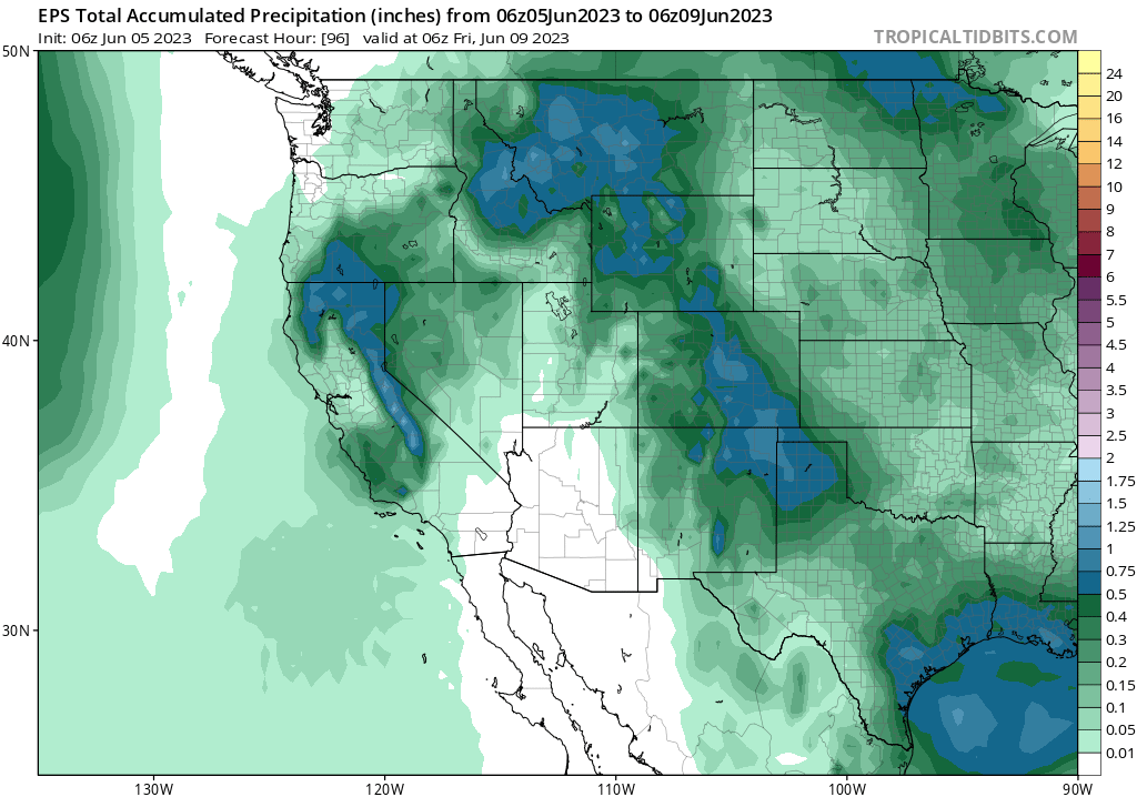
Unusually unsettled June pattern this week, and relatively cool pattern to continue through mid-month
Mostly cooler-than-average conditions continue in CA, in great contrast to most of the rest of the world
Late May and early June have been charactered by (mostly) below average temperatures across California, with a notable lack of exceptional heatwaves across most of the Southwest during the same period. This is largely a continuation of a months-long pattern of unusually cool conditions in CA and along the U.S. West coast. Notably, however, this relative regionalized coolness has been in great contrast to conditions…nearly everywhere else on Earth during the same period, which have featured widespread anomalous and even record-breaking warmth since early last winter. Even in recent weeks, as coastal Californians (and even some inland/valley residents less accustomed to June coolness) have shivered under the marine layer, places in Europe, Asia, and Canada have endured exceptional and record-breaking heatwaves (some of which are ongoing).
Recently, this overall California coolness contrasted with exceptional heat elsewhere has been part of a coherent and persistent hemispheric-scale pattern, characterized by strong blocking ridges in the sub-Arctic and persistent low pressure anomalies in portions of the subtropics (including over the Pacific to the southwest of CA). This has also been associated with an enhanced subtropical jet stream in some places. Why is this pattern occurring, and why has it been so persistent? There’s always a certain amount of randomness (“luck”) when such patterns occur; whether one gets stuck under an unrelenting heat dome or a perennially chilly/unsettled pattern is sometimes just the luck of the draw. But in addition to this, I think there’s a compelling argument to be made that the rapidly developing El Niño event in the tropical Pacific is starting to exert some influence on the global circulation pattern. Additionally, there are numerous patches of exceptional/record-breaking oceanic warmth (associated with the long-term warming caused by climate change) that are not directly attributable to El Niño and may be somewhat altering the atmospheric response to El Niño relative to traditional/canonical teleconnections.
So in some ways this year is a year with no reasonable historical analogues: we’re hurtling toward a potentially strong El Niño event following a rare triple-dip La Niña event amid a period of record oceanic warmth driven by climate change. It’s a combination we haven’t really seen before in the modern era, and it’s a bit difficult to say what it might mean in the months to come. We can certainly look to seasonal predictive models to give us some indication, but those models don’t always represent all possible teleconnections adequately–so I think it’s fair to say there is even more uncertainty than usual regarding how the next 6 months or so will unfold from a regional (and even global) climate perspective.
Cut-off low will bring some unusual weather to parts of CA Mon-Wed: scattered showers and thunderstorms even in some valley/coastal locations

The weather this week, unusual though it might be, is a bit easier to describe! An anomalous cut-off low pressure system is developing today near the coast of Central CA, and will linger over the region through Wednesday. This will bring a surge of relative moist and unstable air to much of northern and central CA, bringing a chance of unusual isolated to scattered coastal/valley showers and thunderstorms along with more widespread thunderstorm activity in the mountains (both Sierra Nevada and even lower Coast Ranges). These scattered showers and thunderstorms could occur just about anywhere north of Santa Barbara, but will still be most likely in and near the mountains/foothills (though some could still make it all the way to the coast). A few strong to even severe cells are possible, mainly over the Sierra and/or northern Central Valley/foothills, today into tomorrow. Localized downpours/some hail are possible under stronger storms.
Fortunately, fire weather concerns associated with this potential early season lightning event will be on the low side. Most or all lightning will be associated with precipitation (including some heavy downpours), and vegetation moisture is not extremely dry in most places (in fact, things are more damp than usual in many areas). It’s still possible there could be a lightning-ignited fire or two in the foothills/grasslands, but the likelihood of numerous and/or dangerous wildfires from this event is quite low by my estimation (you can thank the wet and cool winter/spring for that). So this will be mainly a “novelty weather” event–good for cloud watching (just be careful of lightning!).
Longer term: El Niño continues full steam ahead, though cool conditions will likely prevail across most of CA at least through June
In the longer term, I don’t foresee any obvious periods of exceptional heat in CA–in fact, the pattern may stay pretty stagnant for the next couple of weeks and perhaps through the end of June. This means continued near to below average temperatures will probably prevail over most of California, along with a fairly active mountain thunderstorm pattern (and maybe even another cut-off low pressure system or two). El Niño continues to rapidly develop in the tropical Pacific, and the most likely outcome still appears to be a strong event by autumn. But the details regarding what that means for global climate and California conditions in particular are subject to even more uncertainty than usual, as noted above, due to the historically unprecedented pattern of exceptional oceanic warmth in areas that are not clearly linked to El Niño. The combination is a startling sight to behold…and I’ll continue to reflect on this in the coming weeks and months as things evolve. Stay tuned!