After frustrating false starts, strong indications of a major Pacific jet extension & active pattern by late Dec
A warm and dry November for the Western U.S., but recent record warm soakings in the PacNW
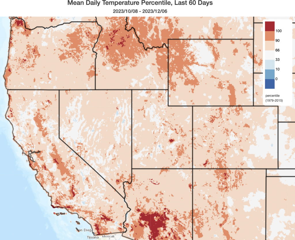
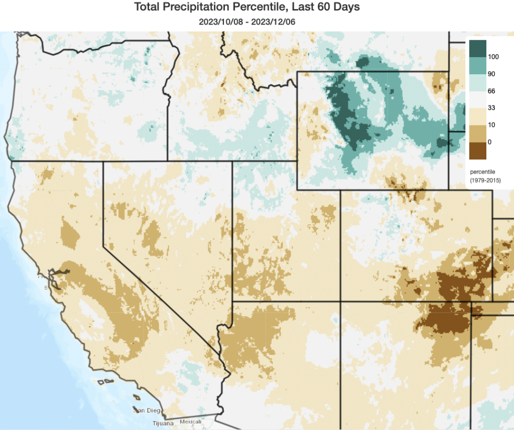
If you were in California this autumn, you probably already noticed: this fall was unusually warm and dry nearly everywhere in the state (and, indeed, across most of the Western U.S.!). Despite that, given unusual summer rainfall thanks to Tropical Storm Hilary in southern California and the legacy of an unusually wet and (by recent standards!) cold winter in California during the 2022-2023 season, no extreme wildfire activity was observed this autumn in the state.
The last month certainly hasn’t been completely dry in the northern half of the state–occasional rain and high elevation snow events have occurred, though they’ve been a bit hard to pinpoint very far in advance (as sometimes occurs during transition seasons). But SoCal has remained decidedly dry through the period–and for this reason, the prospect of renewed Santa Ana winds over the next couple of days will bring with it the prospect of increased wildfire risk (though, again, not extreme risk thanks to fairly typical vegetation moisture conditions). Sierra snowpack, though it did finally receive a modest boost this week, remains behind the curve for early Dec (though it’s quite early in the season, and early season deficits can be erased by a single strong and cold-enough storm).
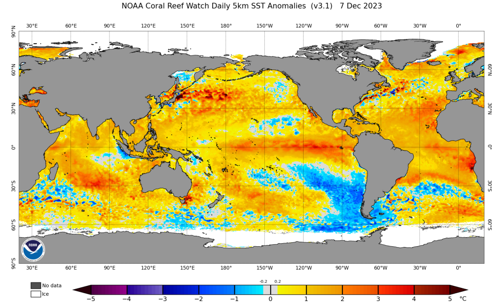
The Pacific Northwest had also been unusually warm and dry for much of the autumn–but that changed dramatically over the past week (well, the “dry” part did, at least). A series of strong to even “extreme” atmospheric river events have soaked the entire PacNW (and extended even down onto the far North Coast of CA at times!), bringing not only record rainfall and moderate to major river flooding and landslides, but also *all time* record warm temperatures to certain areas. In fact, there were quite a few spots that set new daily rainfall records and new daily (or Dec monthly!) high temperature and atmospheric moisture records *within the same 24-48 hr period.* That’s because these ARs have been classic “Pineapple Express”-type storms, with deep moisture transport corridors extending all the way south toward the subtropics. Essentially the entire mid-latitude North Pacific is much warmer than average at present, and this has likely contributed to the remarkable and sometimes record-breaking warmth and moisture within these atmospheric rivers across the Pacific Northwest in recent days.
False starts to an active California pattern in Nov and Dec: some context
As I’ve discussed at length in my recent YouTube virtual office hours, it certainly has been a frustrating month or so for “model riders” of Weather West (and elsewhere). 2 or 3 distinct “pattern changes” toward more active and wetter conditions have, largely, failed to materialize in CA (though the storms are out there–either over the PacNW, as noted above, or in weakened form mainly in NorCal). Although this is aggravating, it’s also worth noting that such “false starts” in the model world are not uncommon, and that’s especially true during the autumn and spring transition seasons before the hemispheric “base state” is more favorable for a faster and more strongly “zonal” (west-to-east-oriented) jet stream.
What do I mean by that? In general, the stronger and more linear the jet stream, the more predictable the large-scale pattern (i.e., the placements of low and high pressure systems, and thus troughs and ridges). The jet stream has a highly predictable seasonal cycle (i.e., essentially every year, it retracts poleward in summer and slides equatorward in winter, as well as becoming stronger in winter and weakening in summer) in synch with meridional temperature gradients at planetary scale. But is also has a high degree of semi-predictable variability: this essentially represents all the daily to weekly “wiggles” in the longwave pattern that dictates warm, dry weather under a ridge of cool, wet weather within a trough. That high frequency variability is essentially what meteorologists try to predict, days to weeks in advance, to understand variations in weather in specific years.
The seasonal cycle of the jet also affects its ability to interact with other “forcings,” or external influences that might alter its position and strength. Such forcings include things like ENSO (and the current El Nino) and the Madden-Julian Oscillation (MJO), though there are others. (BTW–patterns like the PNA are generally *not* considered forcings since they’re simply an index that describes the state of the atmosphere in a given moment, rather than an actual physical cause of variability. Thus, they are sometimes said to be “diagnostic” rather than “prognostic”). This is one of the key reasons why I’m not overly concerned either by this particular dry autumn nor these recent ensemble predictive “busts”: the autumn seasonal base state is very different than the winter base state over the Pacific Ocean, and the Jan-Mar period is much more favorable for “constructive interference” between ENSO, the MJO, and the large scale pattern than the Sep-Nov/Dec period is.
Remarkable Pacific jet extension looks increasingly likely for mid-Dec
I’ll start by reiterating: despite what some of the hate mail in my email inbox might suggest, I can’t control the future; I can only try to predict it. That’s my way of reminding folks there are never any guarantees when predicting the future–I can’t guarantee any particular outcome. But right now, there are some pretty striking things appearing in the long-range ensemble model suites that are worthy of close consideration. That’s especially true as we move from Dec toward Jan, which will be the most favorable period for coherent coupling between the strong El Nino event in the Pacific with the MJO and other more stochastic variations in the North Pacific atmosphere.
For these reasons, when I see images like the one below , I sit up and take notice. Fresh off the presses (the 12z GFS ensemble average from 12/8), it depicts a dramatic eastward extension of the jet stream beginning within a week near the coast of Japan and then eventually extending across almost the entire North Pacific basin toward the California coast (over 5,000 miles away!) by about 2 weeks from now. Keep in mind that this animation is the *average* across dozens of individual ECMWF model members–so there is quite a bit of spatial and temporal smoothing. To see such an extremely strong and straight jet extension extending zonally (longitudinally) for thousands of miles is very unusual, and is often a portent of a very active weather pattern to come shortly thereafter along the U.S. West Coast (and, especially in a year like this one, perhaps California).
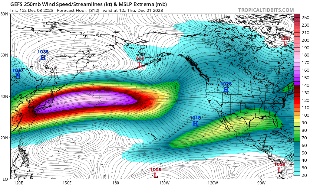
This overall pattern–of a screaming zonal jet extending clean across the Pacific basin by the third week in Dec–is very consistent across models at the moment. Some individual members depict an absolutely howling 225+ knot (255+ mph) jet streak somewhere in the Central Pacific, which would be right up there with some of the strongest jet stream-level winds ever observed. (That’s an especially interesting possibility given new research, out just last week, on how climate change may be strengthening the most extreme jet stream speeds.) This pattern would eventually result in the development of an unusually deep and broad Gulf of Alaska low, with numerous fast-moving baroclinic waves (i.e., mid-latitude cyclones, or winter storms) “riding the polar front” along the powerful zonal jet all the way from Japan to near the U.S. West Coast.
For those interested: all of this appears to be preceded, in classic fashion, by a major “positive East Asia mountain torque” event, which is a fancy way of saying that wind flowing perpendicular to the Tibetan Plateau will actually oppose the Earth’s rotation to such a degree that an acceleration of the planetary wind field (in this case, the downstream Pacific jet stream) is needed to ensure that global angular momentum is conserved. (It’s pretty cool…and also pretty complicated!)
One important thing to remember: this pattern will likely take a full 2 weeks to develop. So California will not instantly see a more active pattern when the jet starts to do some wild things, as now appears highly likely. A relatively dry and warm pattern will continue for the next 7-10 days, then with perhaps gradually more active conditions 10-14 days from now before potentially more dramatic shift toward wet and active conditions after that–most likely sometime during the last week in Dec. But this Pacific-wide rearrangement of the longwave pattern is exactly what we would need to finally break down this wavy jet and mostly “ridgey” pattern that’s stuck around the past couple of months. And all of this might be happening just in time to take advantage of favorable forcing from our strong El Nino, and perhaps the next active cycle of the MJO as well.
One thing to note, although the juncture is still very early and this is speculative: the pattern currently depicted by both the ECMWF and GFS ensemble average (and many of their respective model members) is one that might be highly conducive to strong/warm atmospheric rivers–i.e., Pineapple Express-type events–from late Dec into early Jan. As the Pacific Northwest just experienced, ocean temperatures in the region this extremely strong jet will be traversing are highly unusually warm, so there is definitely some extra moisture out there for any storms that develop to entrain (which can also ultimately feed back to storm strength via latent heat release). The overall hemispheric and synoptic setup also looks like the kind that research suggests is associated with high-impact atmospheric river “families“. So there is at least the *potential* for some very interesting weather along the U.S. West coast by late Dec, and it might will be aimed toward CA.
Is there 100% certainty in this pattern change? Well, the odds of a remarkably strong zonal jet over the Pacific do appear very high at the moment. But the critical time for California remains about 2 weeks out, then the nose of this powerful jet core would possibly arrive near the coast. Will it make it all the way, and will it still be remarkably strong? Will it direct a sequence of strong/moist storms into California in the days following? I’m leaning toward yes at the moment, but as always…things can change, and this is still a fair distance in the future. Uncertainty is high, but this certainly has potential. So: stay tuned! I’ll be updating on various social media sites (including YouTube office hours) in the meantime; if something really big does end up developing, that’ll be the trigger for the next blog post 10-14 days down the line.
Active storm cycle before the New Year kicks off a wet Jan-Mar?
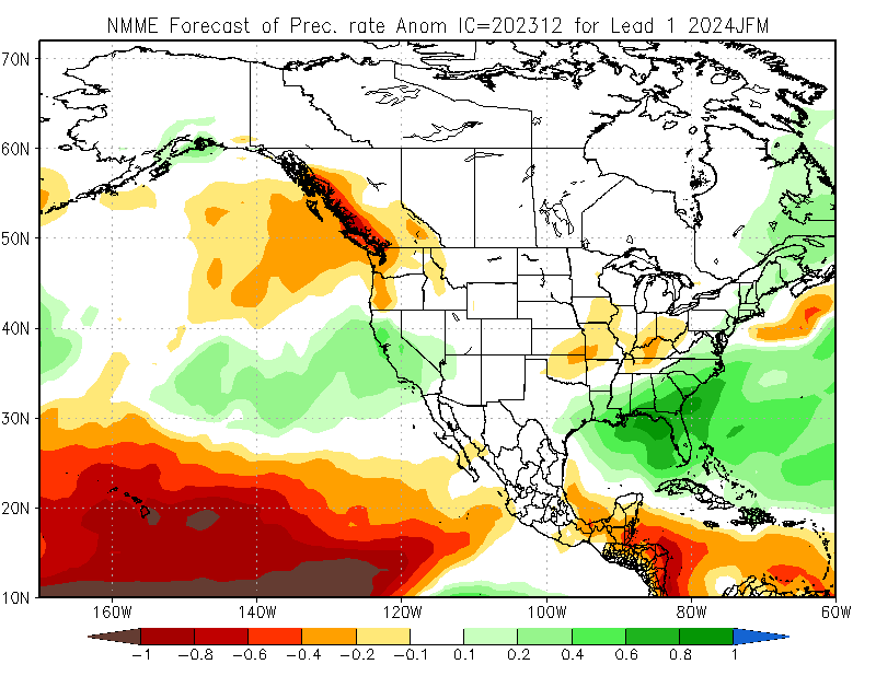
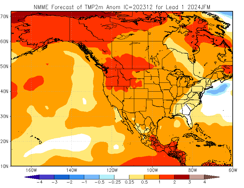
The newest slew of seasonal model predictions for the core winter months–January through March–we just released a couple of days ago. And the theme is very familiar: they continue to point, as they have for months, toward a pretty decent tilt in the odds toward wetter than average conditions in California (especially central and southern CA) during this period. (Notably, they did not do so for the Oct-Dec period.) They also point toward very high confidence in a warmer than average winter across nearly the entire Western U.S., including California. So it would not be tremendously surprising to see above average precipitation but near to below average snowpack in some portions of the Pacific Southwest this year due to this persistent warmth. Elevation will help mitigate that–near and along the mountain range crests, there’s a pretty good shot of hefty accumulations this year–but lower down the slopes, the strong El Nino event plus the long term warming trend might mean that temperatures will be a problem for snow lovers at lower to middle elevations this season.
I would not be too surprised if that potential major pattern change in late Dec discussed above transitions into an overall active pattern continuing into Jan and beyond. but for now, we’ll just have to wait and see how all of this unfolds!
Check out NOAA’s excellent ENSO and (new!) Polar Vortex blogs!
If you like the Weather West blog, you’ll likely find this pair of NOAA blogs worthwhile as well! The NOAA ENSO blog has been around for a while (check out their most recent post in particular for El Nino and seasonal prediction/precipitation teleconnection-related questions!), but the NOAA Polar Vortex Blog is new (but the first post is great, and I suspect future ones will be also). Both of these are fantastic resources connecting cutting-edge science with real-world events using expert perspectives from scientists both within (and outside of) NOAA. P.S. The blog authors often answer questions in the comments section, much as on this site, so that too can be a treasure trove of insights. Altogether, I think this is a really smart initiative by NOAA to engage the public in an ongoing and accessible way–and I hope to see more of these kind of efforts in the future. So…check ’em out!
On the urgent and growing need for institutions to support public-facing weather & climate science
Earlier this week, my perspective piece on the practical challenges of being a public-facing weather and climate scientist-communicator (i.e., an active, “practicing” researcher in the field who also spends a lot of time engaging the public by working with journalists, policymakers, and writing accessible science content like this blog!) was published in Nature. I also propose specific actions that institutions–like universities, research labs, NGOs, companies in the private sector, and funding bodies–can take to help connect “providers of nuance and context” with the wider world. Chief among them: increased administrative flexibility and willingness experiment with new roles and initiatives (sounds boring, but would actually be transformational!) as well as dedicated funding that would make public engagement a core part of scientists’ jobs (rather than an afterthought, which it is today in the context of funding and tangible support).
This piece was motivated partly by my own efforts to find a long-term and sustainable way to continue and expand my work as a climate scientist-communicator (a role that has always been tenuous, and still faces a potential cliff in about six months)–but more broadly by the reality that support for publicly-engaged scientists, practitioners, and domain experts in almost any discipline face essentially the same persistent and arguably increasing barriers to simply doing their jobs! So I’m personally coming at this problem from a weather and climate perspective, for obvious reasons, but I’d also argue it’s all part of a much wider societal “meta problem” regarding the widening gap between accelerating mis/disinformation and the increasingly limited bandwidth of those individuals and institutions inclined to mitigate it.
If you’re interested in reading the full (short) piece yourself, you can use this link to view without a subscription!