A pretty benign autumn weather pattern in CA (so far)
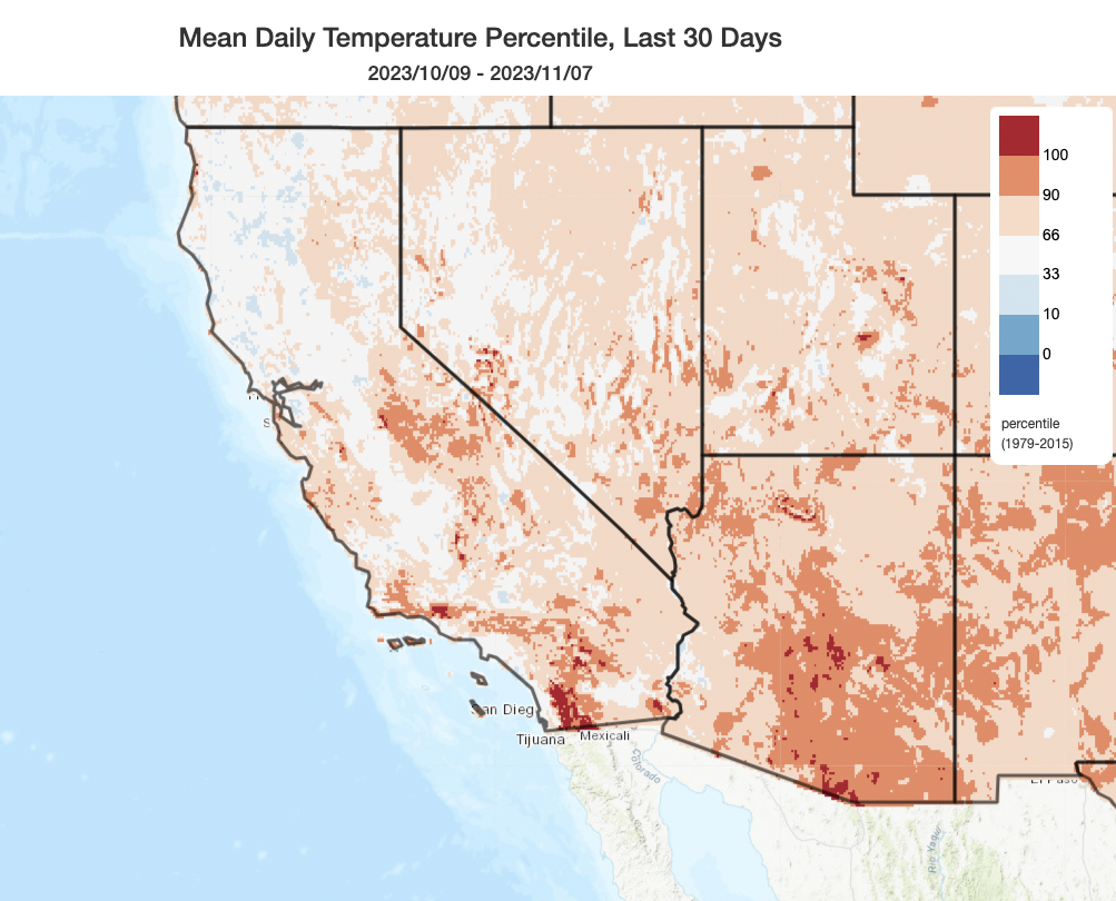
As far as autumns go, 2023 has been mercifully calm from a weather and wildfire perspective across California. Although there several periods of elevated fire weather conditions, and while a couple of modest-sized fires in SoCal did occur (unfortunately burning several structures), September and October 2023 (and, as you’ll see below, almost certainly November 2023 as well) will be remembered for their notable lack of severe wildfire activity. While conditions were in fact significantly warmer than average over the past 30-60 days across much of the state, there were no individually extreme heatwaves (despite a few marginally record breaking days) and also no extreme wind events despite a few occasions of offshore flow. Despite occasional modest precipitation in October, mainly in NorCal, most spots ended up near to below average in the (very) early season precipitation tally.
The real reason for this quiet fire season overall, though? The residual effects of a very wet winter and cool spring–combined with the unusual summer “top up” of soil and vegetation moisture across much of the state associated with Tropical Storm Hilary in August. As predicted as early as mid spring, these conditions yielded greatly reduced vegetation aridity compared to recent extreme/record-breaking drought years–which reduced the likelihood of ignition in the first place, and (more importantly) minimized the level of fire intensity on those fires which did occur. The one exception to this were portions of the northwestern interior of California, where dry lightning events did lead to significant fire activity for much of the summer (though it still paled in comparison to the scale and destructiveness of other events in recent memory).
Major early-season storm(s?) possible next week in California, especially north

Well, that relatively quiet weather pattern won’t last much longer in California. By Monday, an unusually deep low pressure system will set up shop to the west of California and sit there for much of the following week–bringing multiple opportunities for (possibly significant) rain, wind, and mountain snow. This low pressure system will become “quasi-stationary” as it lingers offshore west of San Francisco for several days thanks to upstream blocking near the Aleutian Islands, allowing for the passage of both a primary and possibly multiple secondary cold/cool fronts over several days. At least one or two of these will be associated with (most likely) weak-to-moderate atmospheric rivers.
In this case, though it’s not the atmospheric rivers themselves that will be responsible for the most significant weather: the favorable position of these low pressure systems will place California, at various points next week, under regions of divergent flow aloft thanks to multiple jet streaks moving overhead. That’s generally favorable for the development of surface low pressure and storm strengthening, which is fairly unusual for this early in the season. Additionally, there are some early indications that there may be at least a modest amount of atmospheric instability associated with next week’s systems (possibly enhanced by unusually warm near-shore ocean temperatures along nearly the entire CA coast at present) and possibly some subtropical moisture in the mix as well. That might help increase the likelihood of downpours and possibly some isolated thunderstorms despite the relatively modest atmospheric river conditions most likely to be associated with next week’s system(s).

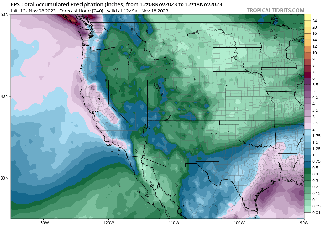
As noted above: this will be a rather slow-moving and broad low pressure system that will linger for several days, and will likely send 2-3 distinct spokes of active weather across California during this period. Each spoke could contain a period of moderate to briefly heavy rainfall along with isolated thunderstorms (especially later in the week). There is also at least a modest possibility that stronger surface low will develop fairly close to the coast at some point next week–which would increase the likelihood of stronger/gusty winds as well. It’s still too early to discern the details, as the greatest likelihood of a stronger storm would come toward the middle or end of next week. But overall, there is strong multi-model ensemble agreement for widespread rain, possibly heavy in some places, at times next week with the additional possibility of an early-season winter-like windstorm if a stronger surface low manages to spin up near the coast. I’d expect the timing of next week’s rain to shift around between now and when it materializes, but overall it’s likely that most of NorCal will see a very respectable (for mid November!) 2-3 inches of rain (locally double that in the usual orographic wet spots) and even the Central Coast/Southern Sierra have a good shot at seeing at least an inch or two of rain. The southern cut-off for significant precipitation in SoCal remains uncertain, but there’s a pretty good shot of at least some light precipitation as far south as Los Angeles by next Thursday or Friday.
In the Sierra Nevada, this will probably be the first heavy snowfall of the season at higher elevations (above 6,000 feet or so). This does not appear to be a particularly warm or cool storm at the moment, but that could change if the system picks up additional subtropical moisture. All in all, conditions could become pretty stormy across much of California at times next week. But is this a sign of the winter to come? Read on…
El Niño continues to strengthen, and will likely tilt odds toward warm (& wet?) winter across much of CA

I’ve been closely following the ongoing development of El Niño since late spring, here on the blog and elsewhere, and so far long-lead predictions of where we’d be by November have actually been spot-on. A strong, and still strengthening east-based El Niño was predicted for November 2023–and that’s exactly what we’ve got right now. Nino 3.4 region ocean temperature anomalies have reached levels typically associated with “strong” events, and are expected to rise still further over the next 1-2 months. Right now, a large number of ensemble members from most of the world’s major modeling centers is suggesting that the present event will peak sometime between December and February at “super El Nino” levels (i.e., becoming a historically rare “very strong” event).
This timing is exactly what we’d expect from a strong El Niño event that had a good shot at influencing California winter temperature and precipitation conditions. So, what do I anticipate for winter 2023-24? Well, as I’ve discussed in the past, it’s complicated because El Niño’s not the only game in town–especially this year, with numerous patches of extremely to unprecedentedly warm water present throughout the global oceans that are not associated with El Niño. These additional regions of very anomalously warm ocean water have the potential to interfere somewhat with the usual El Niño teleconnections over the North Pacific.
The best way to consider all the known puzzle pieces in a single coherent picture is to use coupled ocean-atmosphere model ensembles–which make up the North American Multi-Model Ensemble (NMME) and the International Multi-Model Ensemble (IMME). These are modeling systems that take into account, among other things, the initial state of the global oceans–so even though the combination of a strong El Niño plus record global oceanic warmth elsewhere has not been seen before in the observed record, these tools should be able to generate meaningful predictions nonetheless.
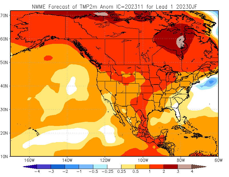
So, what are these model ensembles telling us? Well, the latest update cycle (Nov 8) paints a pretty striking picture of what might occur across North America this winter. The NMME has actually trended quite a bit wetter across most of California for the December-March period, depicting relatively a high statistical likelihood of wetter than average conditions across central and southern California (with a more modest tilt in the odds toward wetter than average conditions in northern California as well). The IMME shows a similar pattern but with decreased amplitude and statistical confidence.
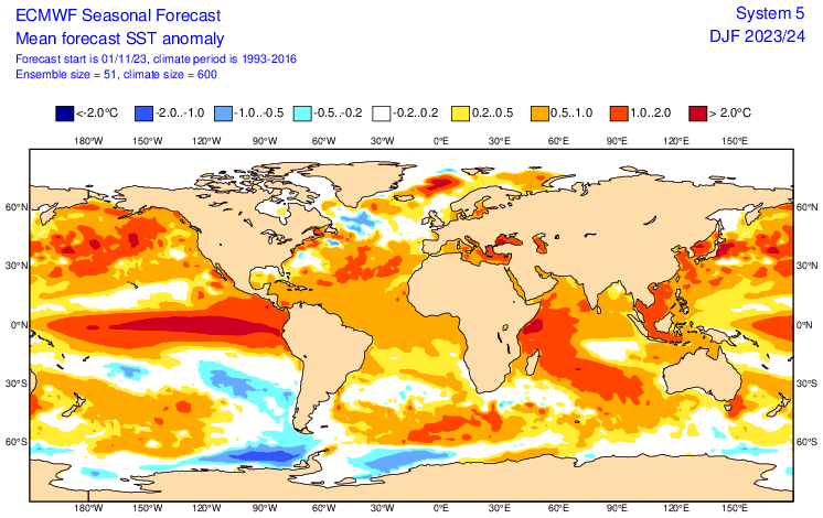
Upon closer inspection, it appears that the ECMWF’s SEAS5 seasonal predictive model is singing somewhat of a different tune, depicting a rather surprising persistence of unusual warm ocean temperatures in the Gulf of Alaska and a lack of persistent low pressure in the same vicinity this winter (something that almost always happens during strong El Niño events). That would be–to put it succinctly–pretty weird if it actually occurred. In fact, the same seasonal predictive system suggests that record-breaking patches of ocean warmth could continue right through winter across the entire North Pacific. And accordingly, the ECMWF is showing a much weaker tilt in the odds toward a wet winter in California (although it’s still there, to a modest degree and mainly across SoCal).
Seasonal prediction remains an extremely tricky business–any anyone that’s being honest will confirm that when it comes to precipitation, specifically, predictive skill remains (on average) disappointingly low in most cases. However, a strong east-based El Niño event might be the one case in which it’s possible to extract meaningful information at seasonal lead times regarding what might be coming down the pike in California. And I still think that’s probably the case this year.
One area where there’s more agreement between models is that this winter is likely to be warmer than average across most or all of California, as well as essentially all of North America (thanks, global warming). It’s extremely unlikely we’ll see a persistent onslaught of very cold conditions and heavy lower elevation snowfalls we saw last winter. That might give more moderate elevation mountain communities something of a break, but would increase the risk of more intense runoff during storms as comparatively higher snow levels lead to higher rain-to-snow ratios.
So, what’s my overall prognosis? I think the single most likely outcome remains a wetter than average winter across central and southern California, and there’s at least a weak tilt in the odds toward a wetter than average winter in northern California as well. As always, all outcomes remain possible: anything from a very dry to very wet winter remains on the table. But the odds of a very wet winter are likely much higher than a very dry winter this year–mainly due to high confidence in a strong to very strong east-based El Niño event peaking around mid-season. That said, and as the ECMWF seasonal prediction is hinting, strange things could happen this year amid historically unprecedented global warmth. And that additional uncertainty goes both ways: it could limit the southeastward extension of the Pacific jet, keeping California drier than it would otherwise be during such a strong El Niño event. But it could also help to seriously “juice up” the atmosphere and add extra moisture to atmospheric rivers that do manage to make landfall–a case of the dynamical response opposing the thermodynamic one.
If I had to give advice to water resource and floodplain managers–something I was doing earlier today, in fact!–I’d advise them to prepare for a warmer and wetter than average winter, especially across central and southern California. Though a wide range of outcomes remain possible, even a modest tilt in the odds toward greater or more intense runoff this year could increase flood concerns: this year, we don’t have the mitigating influence of antecedent severe drought, so flood risk could ramp up relatively quickly following the first storm cycle or two. I’ll continue to monitor as conditions evolve, so stay tuned in the coming weeks!
Regarding my public-facing climate science engagement efforts
As some of you may have already heard from my recent social media threads lamenting the bewilderingly universal difficulty in finding tangible institutional support (in both the public and private sector) for deep and sustained public-facing engagement by scientists, I’m currently seeking creative long-term solutions in light of a upcoming major funding gap for my joint climate scientist-communicator role with UCLA (and NCAR). Check out this thread for more, or feel free to reach out to me directly!
A minor sweepstakes: My extreme weather and climate calendar!
The publisher has announced that they are running a short-fused sweepstakes for a copy of my 2024 extreme weather and climate calendar. There will likely be another before the end of the year, as well as some discount coupons later in this month. If you’d like to enter this one, please click this link! Don’t forget to enter by Friday.
And finally:
I’ve become a bit more distributed across social media lately as the landscape evolves. You can now find me on YouTube (check out my semi-regularly scheduled live virtual office hours!), Bluesky, and a few other places where I’m still not very active at this point. (Yes, I’m still on Twitter too.)
And, since some have recently asked, I recently created an Instagram account where I plan to irregularly and exclusively post some of my own photographs of clouds and other weather-related phenomena–so feel free to check that out as well! (But don’t expect any hard-hitting weather and climate analysis there–you know where else to go for that!)
Discover more from Weather West
Subscribe to get the latest posts sent to your email.