More inland heat before late July reprieve amid record-hot summer to date & escalating Western wildfires
Yes, it really has been record hot this summer away from the coast. Again.
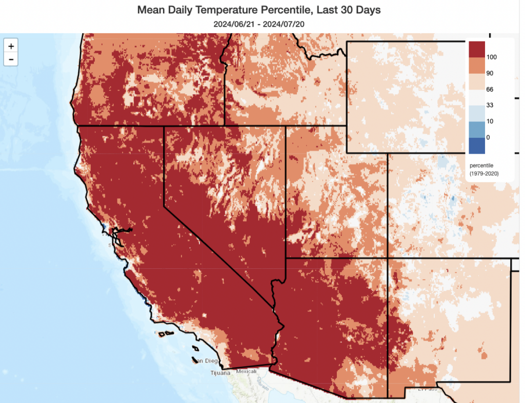
Well, here we are…again. The past 30 days has already been the warmest such period on record across most of California (away from the immediate coast) and much of the Southwestern U.S. If that sounds uncomfortably familiar, well…perhaps it should: most of the very same regions have broken all-time summer temperature records 2, 3, or even more times in the past decade.
The most recent heat has been especially punishing across areas well inland and also at higher elevations, where an astonishingly persistent thermal belt has kept temperatures in the 80s and even locally 90s throughout the night for days on end. Not to be outdone, though, quite a few locations in CA and NV tied or broke all-time temperature records (for any calendar date in any year on record), including Redding, Ukiah, Lancaster, Palm Springs, and Las Vegas (among others). Countless other locations broke daily and monthly temperature records, as well as overnight (warm) minimum temperature records, as well as setting new consecutive and/or cumulative streaks of daytime temperatures exceeding high levels (100, 105, or 110 degrees–depending on location). Redding, quite notably, broke all its all-time temperature records on 1 to 23 day timescales (i.e., hottest 1-day, 2-day, 3-day…all the way to 23-day) period on record during this incredible persistent heatwave.
Adjacent states have become exceptionally hot in recent days, as well, with cities in Oregon, Washington, Idaho, and Nevada all setting new cumulative/consecutive hot temperature streak records. And not to be outdone, record heat has also extended well northward into western Canada–in recent days, locations in interior British Columbia set new record extreme temperature “streaks” and experienced some of the hottest single days on record since the record-shattering heat event back in June 2021.
In short: it has been exceptionally hot, for an exceptionally long period of time, unless you are along the immediate California coastline (where temperatures have still been somewhat warmer than average, but certainly not record-breakingly so, over the past month). Given what has already transpired, and the forecast for the next week or so, it’s quite likely that much of California and the Southwest will end up experiencing their hottest July on record (and in many cases their hottest single month on record). This appears likely to be the case in Death Valley, which (if current forecasts hold) will likely report the hottest month reliably recorded anywhere on Earth at the end of July 2024–and possibly by a considerable margin.
(Non-extreme) heat again this week before late July cooling
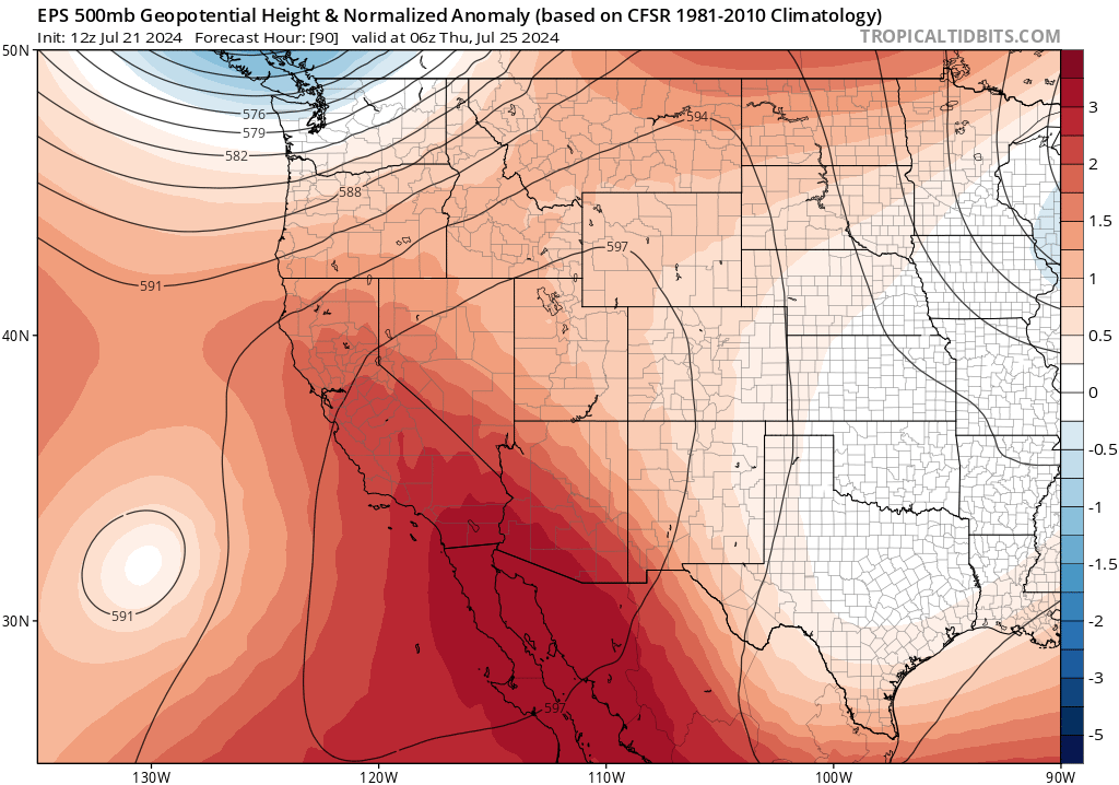
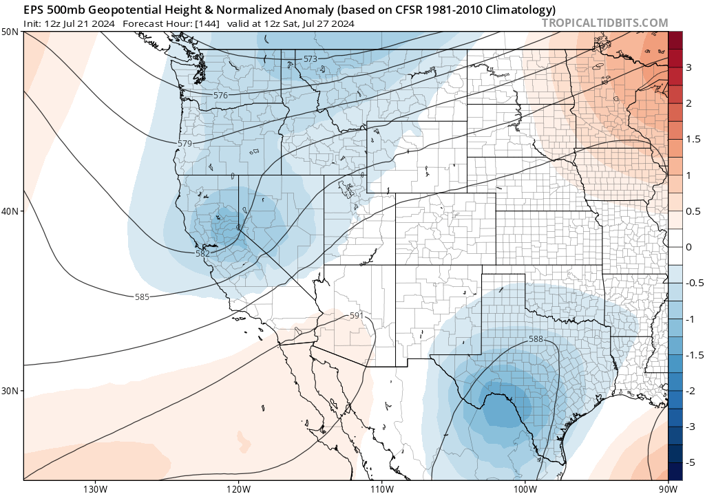
Well, if you’re at higher elevations or well inland from the coast, it’s already hot again and going to get hotter over the next 48 hours. That’s the bad news. The good news is that this week’s heat will be nowhere near as extreme or persistent as the last round. The even better news? It appears that the end of July will actually feature a brief break in the anomalously strong ridge across the West Coast and a brief interlude of (weak) summer troughing! This will help knock down the ridge for a bit and bring a refreshing period of near or even slightly below average temperatures for a few days. The downside? There may be some stronger southwest winds in a few spots (particularly higher elevations) that could increase fire risk–especially for large/remote fires already burning in forested settings in CA/OR. But overall, this temporary pattern shift will offer some further relief after the early week resurgence in heat over the next few days.
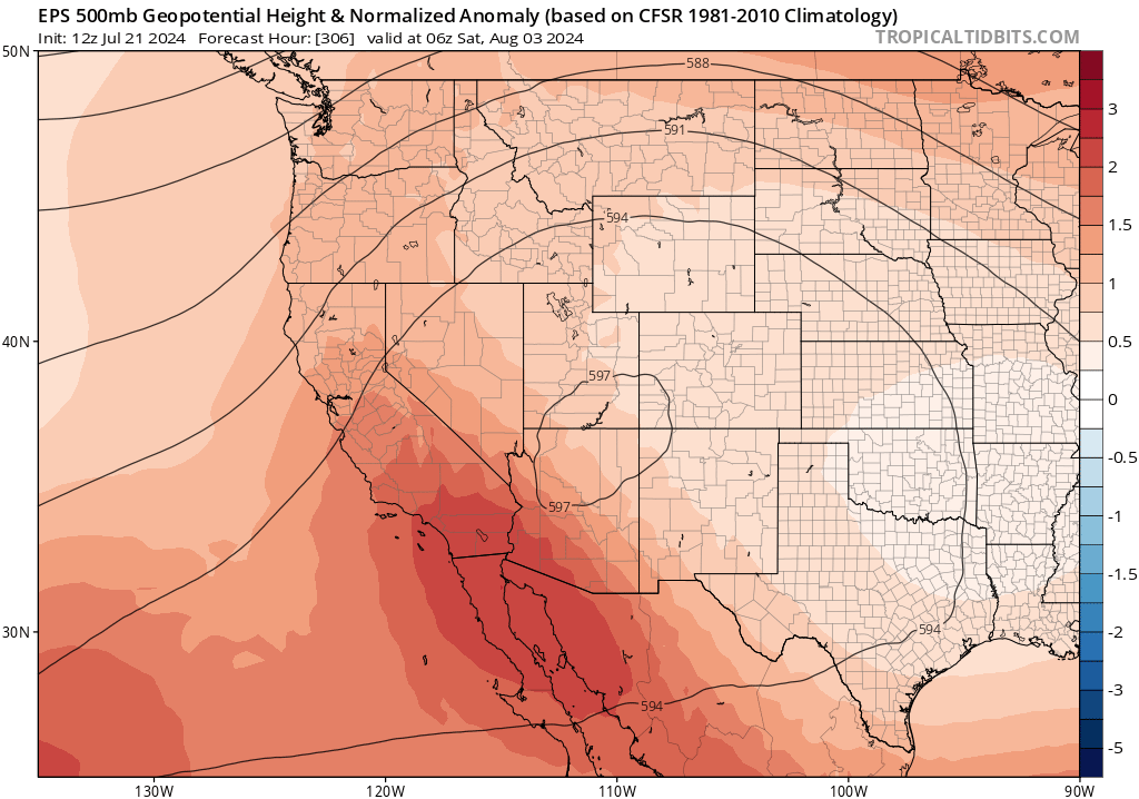
Renewed anomalous heat by early Aug, and beyond?
Enjoy the cooler weather in late July, because all indications are that it won’t last long. There are already strengthening signs in the multi-model ensembles that another more severe and persistent round of heat generated by an anomalously strong mid-tropospheric ridge will likely materialize by early August. It’s too early to say how intense this heat might be, but there are at least some ensemble members that would be conducive for record-breaking August heat in some places. Again. And the longer-range sub-seasonal outlook? Well, that continues to point to high odds of much warmer than average temperatures in August and into September across California–anomalous warmth that will be progressively more likely to spread westward to the immediate coast later in Aug and Sep.
Escalating wildfire activity across western U.S. and Canada likely to continue for weeks to months
Fire Season 2024 is now already (as earlier predicted) escalating rapidly throughout western North America. During the recent record heatwave, numerous fires broke out in California–some of which have become large (in the 10s of thousands of acres) and causing some loss to structures. In recent days, however, this elevation in wildfire activity (both ignitions and fire behavior) has become much more widespread along the West Coast, from southern CA northward into Oregon, Washington, and western Canada (including not only interior British Columbia but also northern Alberta, Saskatchewan, and the Northwest Territories). Many of these new fires, fostered by record warmth and worsening drought in many areas, were sparked by a mix of wet and dry thunderstorms. Several still-burning major fires in CA, mainly in the Southern Sierra, were sparked by lightning; hundreds more, however, have ignited in recent days across OR, WA, and western Canada with yet more ignitions likely due to widespread lightning again today.
One notable statistic: the recent period of sustained record heat in California and parts of Oregon appears to have yielded a record-high amount of atmospheric evaporative demand–i.e, “atmospheric thirstiness”–during this period as well, drying vegetation to record-dry levels in some areas for the time of year and accelerating seasonal drying trends even at moister higher elevation regions. This sets the stage for what might come next, wildfire wise, in the coming weeks/months.
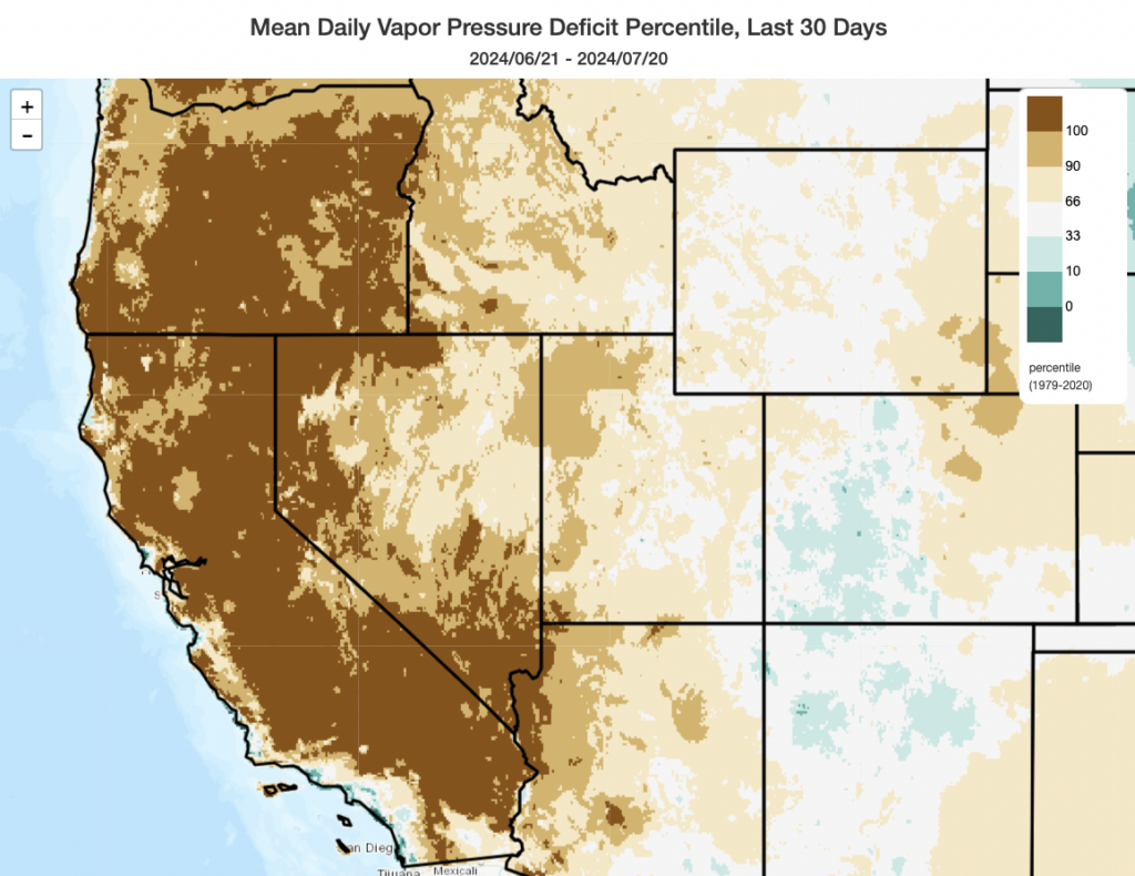
Unfortunately, the fire weather outlook for virtually all of these areas looks favorable for continued escalation in fire behavior/intensity and ignition likelihood over the next couple of weeks. More lightning is likely, some of it dry or nearly so (mainly outside of CA, though some is still possible in the far northern mountains and Sierra Nevada), along with continued anomalous heat into August except for a brief cooler interlude in late July (which may compensate by temporarily increasing southwesterly winds in fire areas). With the expected expansion of the anomalous intense and broad Western ridge again by early August, the first half of the month may well be characterized by once again hotter than average temperatures and below average precipitation along the West Coast and across the interior of western Canada. In fact, the core summer monsoon region in the Desert Southwest, which has benefited from a couple of recent weeks of unusually active thunderstorm activity, may also dry out considerably during this period amid what would usually be the peak of the monsoon–perhaps allowing seasonal predictions of a drier-than-average monsoon in many areas to come closer to reality despite a wetter-than-expected start (except perhaps in New Mexico, which does appear to have gotten quite a lot of water in recent weeks). Firefighting resources are starting to become stretched thin as numerous large fires spread in both the western U.S. and Canada (which share a finite pool of personnel and equipment during peak fire season), so as extreme fire weather episodes occur in the coming weeks (lightning, heat, and/or wind events) things might become progressively dicier.